
The evolution and ecology of Antarctic sea floor communities
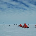
The evolution and ecology of Antarctic sea floor communities is a UKRI Future Leaders Fellowship, led by Dr Rowan Whittle, looking at the past, present and future of life at …
Exploring the climate history and the geological structure and evolution of the rocks and mountains of Antarctica’s continental interior provides clues to past, present and future environmental change. Under-ice lakes, mountain chains buried by up to 4km ice, and sea bed sediments surrounding the frozen continent provide an unparalleled record of how the Earth’s climate has changed over millions of years.
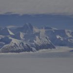
Antarctica — our fifth largest continent — is 58-times the size of the UK. Buried beneath the snow and ice that cover more than 99% of its surface are chains of mountains the size of the Alps, while around the edge of the continent, and running across its centre, are other large mountain ranges that rise above the ice.
Geologists have studied the rocks in these mountains for more than a century. These rocks reveal that Antarctica has moved vast distances over millions of years. More than 500 million years ago, Antarctica straddled the equator, and the warm, shallow seas that covered the continent supported trilobites and other organisms long since extinct.
For hundreds of millions of years, Antarctica was locked in the centre of a giant continent called Gondwana. Around 150 million years ago, this supercontinent began to split apart, forming the modern continents of Australia, India, South America and Africa. At that time, instead of ice and snow, Antarctica was covered in dense forest and dinosaurs roamed its coastal plains.
Rocks and fossils tell us that the continent began to cool about 80 million years ago and around 35 million years ago, a vast ice sheet blanketed East Antarctica.
Locked in Antarctica’s rocks and in the sea bed around the continent is an unparalleled record of how the Earth’s climate has changed over millions of years. During the past 50 years, geologists at British Antarctic Survey (BAS) have built up the world’s largest archive of Antarctic rocks and fossils and made major contributions to our understanding of Antarctica’s ancient history.
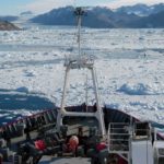
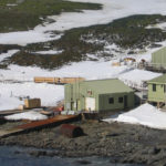
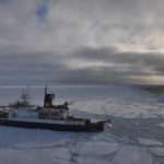
Today, using BAS’s Royal Research Ship James Clark Ross to carry out surveys at sea and BAS aircraft to study remote corners of the continent, BAS geologists are using these ancient records to help predict how future climate change will affect not only Antarctica, but also the rest of the world.
Scientists at BAS are using advanced computer models to show what the Antarctic may have looked like 3 million years ago. The models suggest that during the mid-Pliocene warm period, the ice retreated significantly from the edges of the continent and was replaced by a sparse tundra vegetation. That a rise in temperature of only a few degrees centigrade had such a profound effect on Antarctica is a stark reminder of what might happen in the near future.
The evolution and ecology of Antarctic sea floor communities is a UKRI Future Leaders Fellowship, led by Dr Rowan Whittle, looking at the past, present and future of life at …
The Greenland Ice Sheet is decaying at an accelerating rate in response to climate change. Warm ocean waters moving through the fjords eventually meet the faces of marine-terminating glaciers, increasing …
Bedmap is a collaborative community project with the aim to produce a new map and datasets of Antarctic ice thickness and bed topography for the international glaciology and geophysical community, …
The HEXPLORES project aims to explore for active hydrothermal vents in the Red Sea Rift. Although the Red Sea Rift hosts the world’s largest submarine metalliferous sulphide deposit, no active …

The international IceAGE (Icelandic marine Animals: Genetics and Ecology) project, initiated in 2008 and managed by Drs Saskia Brix and Karin Meißner from DZMB Hamburg, Germany, builds on data obtainedby …

The GRADES-IMAGE science programme was a British Antarctic Survey-funded project over the Antarctic Peninsula and Filchner-Ronne Ice Shelf. The aim of the programme was to image englacial layering and bedrock …

The NERC funded SIWHA_CO2 project “Sea Ice and Westerly winds during the Holocene in coastal Antarctica, to better constrain oceanic CO2 uptake” will be a breakthrough in our understanding of how …
The ice sheets of Antarctica can be several kilometres thick, and contain precious information about the past climate. However, the bottoms of the ice sheets are melting, erasing this information. …
THOR is a ship-based and ice-based project that will examine sedimentary record both offshore from the glacier and beneath the ice shelf, together with glacial landforms on the sea bed, …
GHC (“Geological History Constraints”) will gather information about past ice sheet behaviour and relative sea level change in the Thwaites Glacier system. Determining the timing and magniture of past episodes …
1 June, 2023
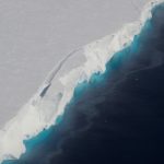
Concern is rising about tipping points in the Antarctic region (Armstrong et al., 2022). Recent heatwaves, changes in the Southern Ocean, and a reduction in the extent of Antarctic sea …
27 October, 2021
15 January, 2014
What lies beneath – scientists discover giant trench under Antarctic Ice A massive ancient subglacial trough — deeper than the Grand Canyon — has been discovered by a team of …

13 December, 2013
Mapping of remote Antarctic frontier will help model its reaction to climate change and unlock secrets of Earth’s ancient supercontinents. For the first time scientists have begun mapping one of …
18 November, 2013
Series of large earthquakes in Scotia Sea close to South Orkney Islands A series of earthquakes has been detected in the Scotia Sea region close to the British Antarctic Survey’s …
3 October, 2013
Map makers rewarded for stunning recreation of Antarctic without ice A colourful British Antarctic Survey map has won a coveted award. The map, created by the institution’s MAGIC (Mapping and …
2 July, 2013
Lake Ellsworth project leader awarded international prize Professor Martin Siegert, the principal investigator on the sub-glacial Lake Ellsworth project, has been awarded the 2013 Muse Prize. The award is in …
8 March, 2013
Bedmap2 gives scientists a more detailed view of Antarctica”s landmass Scientists at the British Antarctic Survey have been working with a host of international collaborators to present the most detailed …
16 January, 2013
New Antarctic geological timeline aids future sea-level predictions Radiocarbon dates of tiny fossilised marine animals found in Antarctica’s seabed sediments offer new clues about the recent rapid ice loss from …
25 July, 2012
Hidden rift valley discovered beneath West Antarctica reveals new insight into accelerating ice loss Scientists have discovered a one mile deep rift valley hidden beneath the ice in West Antarctica, …
16 January, 2012
Engineering team completes ambitious Antarctic expedition in the ‘deep-field’ A team of four British Antarctic Survey (BAS) engineers has returned to the UK after completing a gruelling journey to one …
16 November, 2011
Gamburtsev Mountains enigma unraveled in interior East Antarctica The birth of the Gamburtsev Subglacial Mountains buried beneath the vast East Antarctic Ice Sheet — a puzzle mystifying scientists since their …