Gamburtsev Mountains enigma unraveled in interior East Antarctica
The birth of the Gamburtsev Subglacial Mountains buried beneath the vast East Antarctic Ice Sheet — a puzzle mystifying scientists since their first discovery in 1958 — is finally solved. The remarkably long geological history explains the formation of the mountain range in the least explored frontier on Earth and where the Antarctic Ice Sheet first formed. The findings are published this week in the journal Nature.
A seven-nation team of scientists explored the Gamburtsev Subglacial Mountains — buried beneath up to 3km of ice — during the International Polar Year (2007–09) by using two twin-engine aircraft equipped with ice penetrating radars, gravity meters and magnetometers.
By analyzing the new data, the researchers describe the extraordinary processes — which took place over the last billion years — that created and preserved a root beneath the mountains and the East Antarctic rift system — a 3,000km long fracture in the earth’s surface that extends from East Antarctica across the ocean to India.
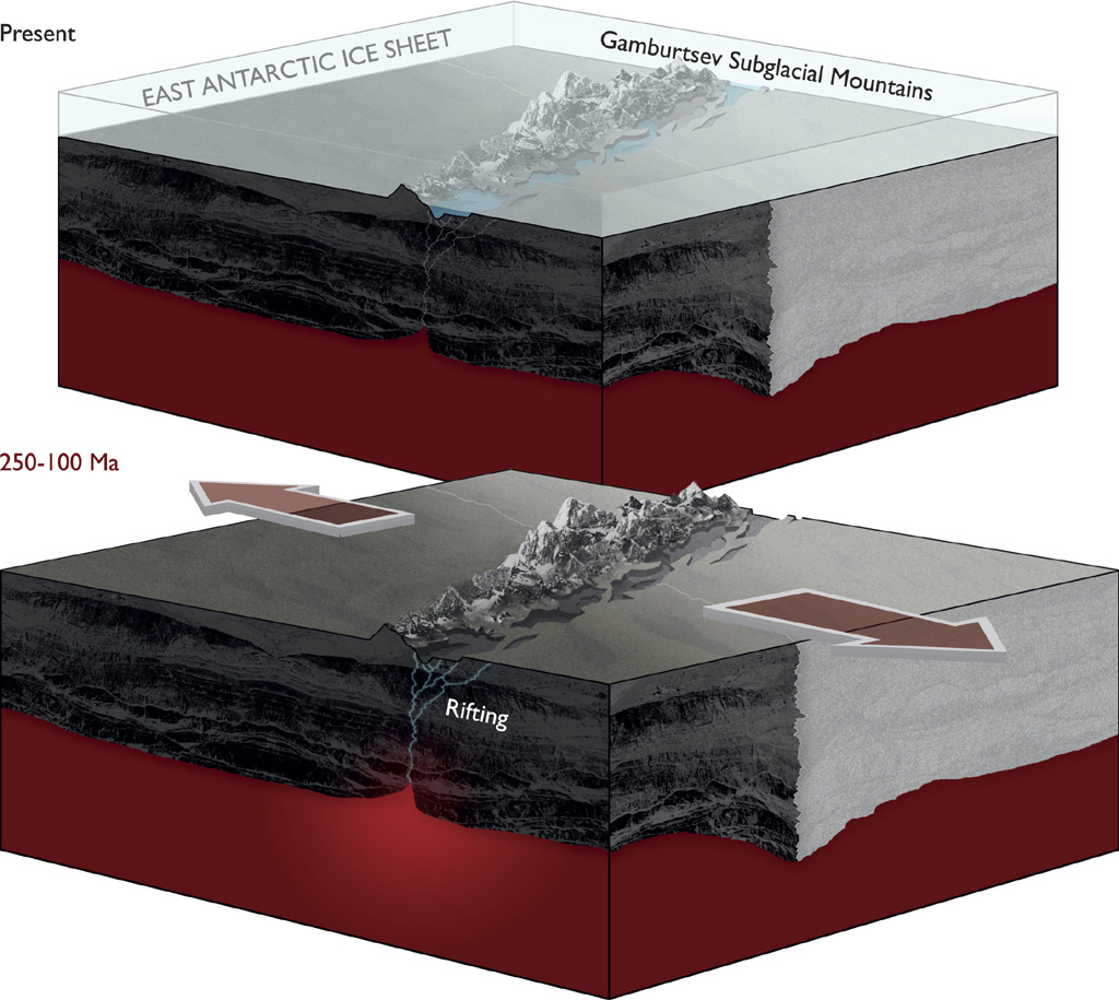
One billion years ago, before animals and plants evolved on Earth, several continents (or micro-continents) collided, crushing the oldest rocks of the mountain range together. This event formed a thick crustal root extending deep beneath the mountain range. Over time these ancient mountains were eroded but the cold dense root was left behind.
Around 250–100 million years ago — when dinosaurs walked the Earth — rifting paved the way for the supercontinent Gondwana to break apart, which included Antarctica, causing the old crustal root to warm. This rejuvenated crustal root, together with the East Antarctic Rift forced the land upwards again reforming the mountains. Rivers and glaciers carved deep valleys and this helped uplift the peaks to create the spectacular landscape of the Gamburtsevs, which resemble the European Alps. The East Antarctic Ice Sheet, which formed 34 million years ago and covers 10 million km2 of our planet (an area the size of Canada), protected the mountains from erosion.
Lead author, Dr Fausto Ferraccioli from British Antarctic Survey says,
“Understanding the origin of the Gamburtsevs was a primary goal of our International Polar Year expedition. It was fascinating to find that the East Antarctic rift system resembles one of the geological wonders of the world — the East African rift system — and that it provides the missing piece of the puzzle that helps explain the Gamburtsev Subglacial Mountains. The rift system was also found to contain the largest subglacial lakes in Antarctica.”
Co-author, Dr Carol Finn from US Geological Survey says,
“Resolving the contradiction of the Gamburtsev high elevation and youthful Alpine topography but location on the East Antarctic craton by piecing together the billion year history of the region was exciting and challenging. We are accustomed to thinking that mountain building relates to a single tectonic event, rather than sequences of events. The lesson we learned about multiple events forming the Gamburtsevs may inform studies of the history of other mountain belts.”
Co-author, Dr Robin Bell of Columbia University’s Lamont-Doherty Earth Observatory says,
“The next steps will be to assemble a team to drill through the ice into the mountains to obtain the first rock samples from the Gamburtsevs. Amazingly, we have samples of the moon but none of the Gamburtsevs. With these rock samples we will be able to constrain when this ancient piece of crust was rejuvenated and grew to a magnificent mountain range.”
”It is very fitting that the initial results of Antarctica’s Gamburtsev Province (AGAP) project are coming out 100 years after the great explorers raced to the South Pole,” said Alexandra Isern, Programme Director at the National Science Foundation. “The scientific explorers of the AGAP project worked in harsh conditions to collect the data and detailed images of this major mountain range under the East Antarctic Ice Sheet. The results of their work will guide research in this region for many years to come.”
These discoveries in central East Antarctica have significant implications for understanding mountain building and ice sheet evolution within continental interiors.
ENDS
Schematic showing that proposed rifting processes within the East Antarctic Rift System provided the tectonic trigger for uplift of the Gamburtsev Mountains.
Issued by British Antarctic Survey
Media contacts:
British Antarctic Survey media contact:
Athena Dinar, Tel: +44 (0)1223 221414; Mobile: +44 07736 921693; email: amdi@bas.ac.uk
Audrey Stevens, Tel: +44 (0)1223 221230; email: auev@bas.ac.uk
US Geological Survey media contact:
Heidi Koontz, Tel: +1 720-320-1246; email: hkoontz@usgs.gov
Lamont-Doherty Earth Observatory media contact:
Kim Martineau, Tel: +1 845-365-8708; Mobile: +1 646-717-0134; email: kmartine@ldeo.columbia.edu
Bundesanstalt für Geowissenschaften und Rohstoffe media contact:
Andreas Beuge, email: info@bgr.de
Science contacts:
British Antarctic Survey:
Dr Fausto Ferraccioli, Tel: +44 (0)1223 221577; email: ffe@bas.ac.uk
Dr Tom Jordan, Tel: +44 (0)1223 221305; email: tomj@bas.ac.uk
US Geological Survey:
Dr Carol Finn, Tel: +1 303-517-9576; email: cfinn@usgs.gov
Lamont-Doherty Earth Observatory of Columbia University:
Dr Robin Bell, Tel: +1 845 – 365 – 8827; email: robinb@ldeo.columbia.edu
Bundesanstalt für Geowissenschaften und Rohstoffe:
Dr Detlef Damaske, Tel: +49 511 6432692; email: detlef.damaske@bgr.de
Stunning images from Antarctica and the AGAP project to illustrate this story can be downloaded from
ftp://ftp.nerc-bas.ac.uk/pub/photo/Ghost_Mountains
A narrated animation showing the topography of the Antarctic Gamburtsev mountains
Get the Flash Player to see this player.
Notes for Editors
The paper — East Antarctic Rifting Triggers Uplift of the Gamburtsev Mountains — is published in Nature by Fausto Ferraccioli, Tom Jordan and Lester Anderson of British Antarctic Survey; Carol Finn from the US Geological Survey; Robin Bell from Lamont-Doherty Earth Observatory — part of the Earth Institute at Columbia University; and Detlef Damaske of the Bundesanstalt für Geowissenschaften und Rohstoffe in Germany. For around two and a half months in 2009, two science teams carried out an aerogeophysical survey of Antarctica’s Gamburtsev Province (AGAP). The British Antarctic Survey and Australian Antarctic Division teams worked from one of the deep-field camps known as AGAP North. The US-German-Japanese science teams worked from AGAP-South.
Further information about the project can be found at:
The work was funded by grants from the U.S. National Science Foundation and was launched in conjunction with the International Polar Year, an effort to study the Arctic and Antarctic spanning 2007–2009 and involving research by thousands of scientists from more than 60 nations. Support also came from the Natural Environment Research Council of Britain and the British Antarctic Survey, the Federal Institute for Geosciences and Resources in Germany and the Polar Research Institute of China.
Gondwana — was one of two ancient supercontinents produced by the first split of the even larger supercontinent Pangaea about 200 million years ago. The supercontinent included most of the landmasses in today’s Southern Hemisphere including Antarctica, South America, Africa, Madagascar, Australia, and the Indian subcontinent.
British Antarctic Survey (BAS), a component of the Natural Environment Research Council, delivers world-leading interdisciplinary research in the Polar Regions. Its skilled science and support staff based in Cambridge, Antarctica and the Arctic, work together to deliver research that underpins a productive economy and contributes to a sustainable world. Its numerous national and international collaborations, leadership role in Antarctic affairs and excellent infrastructure help ensure that the UK maintains a world leading position. BAS has over 450 staff and operates five research stations, two Royal Research Ships and five aircraft in and around Antarctica.
International Polar Year 2007–2009 was the largest coordinated international scientific effort for 50 years. Featuring more than 200 Arctic and Antarctic projects, IPY involved 50,000 people — including scientists, students and support staff — from more than 60 nations. Together, they set out to discover more about the Polar Regions and their critical influence on the rest of the planet.