PRESS RELEASE: Assessing potential sea level rise
New Antarctic geological timeline aids future sea-level predictions
Radiocarbon dates of tiny fossilised marine animals found in Antarctica’s seabed sediments offer new clues about the recent rapid ice loss from the West Antarctic Ice Sheet and help scientists make better predictions about future sea-level rise. This region of the icy continent is thought to be vulnerable to regional climate warming and changes in ocean circulation.
Reporting this month in the journal Geology a team of researchers from British Antarctic Survey (BAS), the Alfred Wegener Institute for Polar and Marine Research (AWI) and the University of Tromsø presents a timeline for ice loss and glacier retreat in the Amundsen Sea region of West Antarctica. The team concludes that the rapid changes observed by satellites over the last 20 years at Pine Island and Thwaites glaciers may well be exceptional and are unlikely to have happened more than three or four times in the last 10,000 years.
This study is part of an urgent international effort by polar scientists to understand if the recent rapid changes are unusual in the geological past.
The team studied the average rate of glacial retreat since the end of the last Ice Age around 12,000 years ago. Their work centred on Pine Island and Thwaites glaciers, which drain ice from the West Antarctic Ice Sheet into Pine Island Bay.
Lead author Dr Claus-Dieter Hillenbrand from BAS says,
“As snow and ice builds up on the vast Antarctic Ice Sheet, the ice flows from the centre of the continent through glaciers towards the sea where it often forms floating ice shelves and eventually breaks off as icebergs. The floating ice shelves hold back the ice on land. A critical issue for us is to understand how the ‘grounding line’ — the position where the ice sitting on land (glaciers) begins to float (ice shelves) — has retreated landward over time. Satellite data are available only for the last 20 years and show that since 1992 the Pine Island and Thwaites glaciers have experienced significant thinning (melting), flow acceleration and rapid landward retreat of their grounding lines, with that of Pine Island Glacier having retreated up to 25 km. It’s possible that the grounding lines may retreat even further inland over coming decades. Our study has revealed that episodes of fast glacier retreat similar to that observed over recent decades can only have occurred very rarely during the previous 10,000 years.”
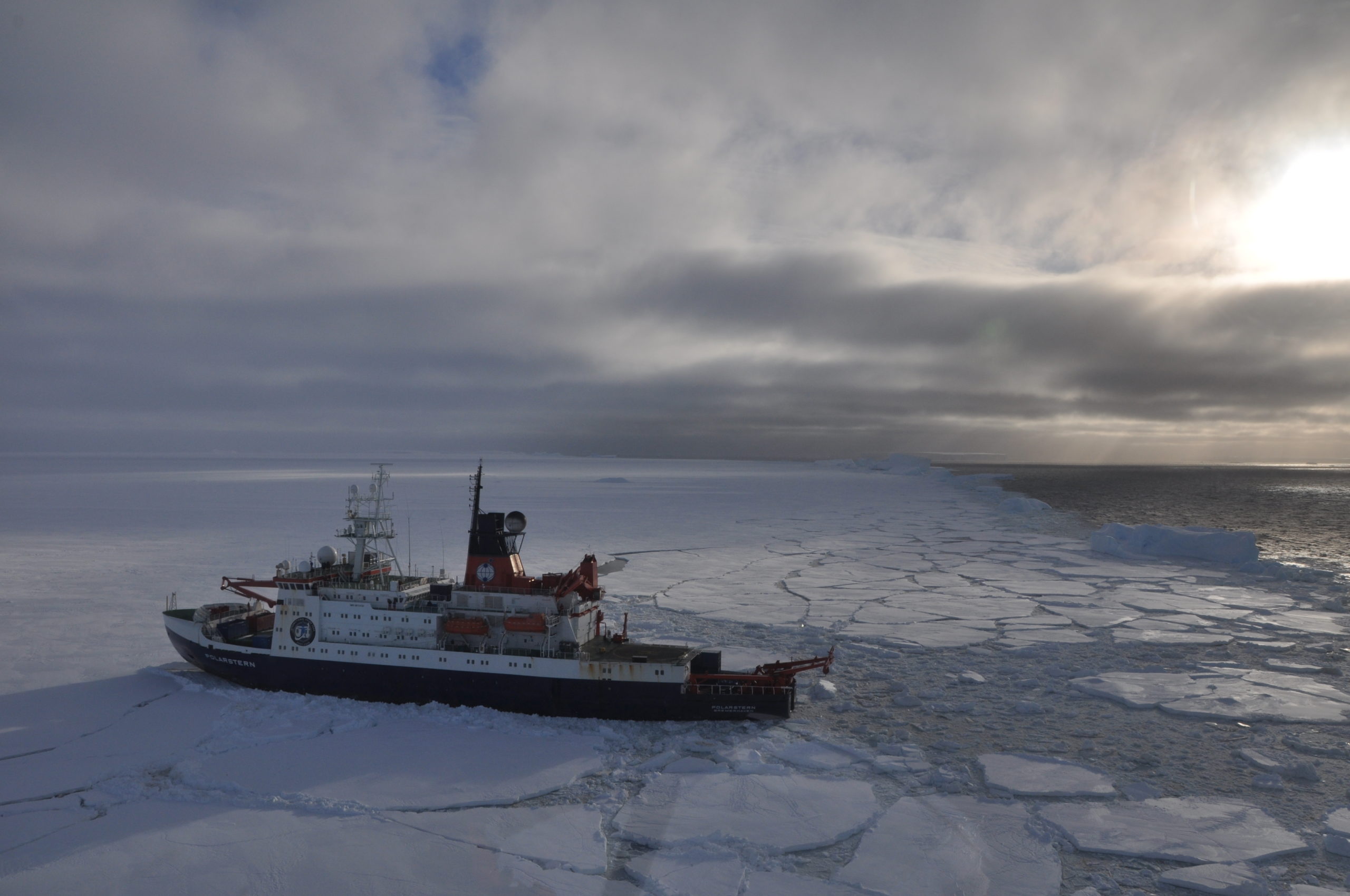
The investigation was carried out in 2010 during an expedition on-board the German research ship RV Polarstern. The science team used gravity corers up to ten metres long to extract mud from the sea floor of the continental shelf in the Amundsen Sea.
Co-author Dr Gerhard Kuhn from AWI explains,
“It was important to get a better understanding of the rapid retreat that we see in the satellite data. As coring targets we selected three relatively shallow undersea ridges that lie within 110 kilometres of the current grounding line and flank a deep glacial valley which was carved into the sea bed by the glaciers during past ice sheet advances. These locations gave us the best chance to collect the tiny skeletons and shells of animals made of calcium carbonate. Such ‘calcareous’ microfossils are critical for using the radiocarbon technique to determine the age of the sediments, but they are normally extremely rare on the Antarctic continental shelf.”
Co-author Dr James Smith, also from BAS, adds,
“First we determined the distance between the core locations and the modern position of the grounding line. Then by dating the type of sediment material deposited at a core site in the open ocean (after the grounding line had moved further landward), we were able to calculate the average rate of glacier retreat over time.”
This new research will be used to improve the accuracy of computer models that are essential to predict future ice loss in the Amundsen Sea sector of the West Antarctic Ice Sheet and its likely contribution to global sea-level rise. Over the last two decades the melting of West Antarctic glaciers has contributed significantly to sea-level rise (recent studies have suggested that continued melting would raise global sea level by up to 0.3 mm a year).
Some of the radiocarbon dating work was undertaken at the Natural Environment Research Council Radiocarbon Facility (Environment). The research was funded by the Natural Environment Research Council (NERC) and the Alfred Wegener Institute (AWI).
ENDS
The paper “Grounding-line retreat of the West Antarctic Ice Sheet from inner Pine Island Bay” is published in January’s edition of Geology by Claus-Dieter Hillenbrand, James Smith, Alastair Graham, Robert Larter, Rachel Downey and David Vaughan of the British Antarctic Survey, Gerhard Kuhn, Johann Klages of the Alfred Wegener Institute of Polar and Marine Research, Steven Moreton of the NERC Radiocarbon Laboratory and Matthias Forwick of the University of Tromsø.
Contacts
Please contact the British Antarctic Survey Press Office for a copy of the paper, to arrange interviews with scientists listed below and for supporting Antarctic images.
- Paul Seagrove, Tel: +44 (0)1223 221414; email: psea@bas.ac.uk
- Heather Martin, Mobile: +44 (0)7740 22229; email: hert@bas.ac.uk
Scientists’ contact details:
- Dr Claus-Dieter Hillenbrand, BAS, Tel: +44 (0)1223 221340; email: hilc@bas.ac.uk
- Dr James Smith, BAS, Tel: +44 (0)1223 221229; email: jaas@bas.ac.uk
- Dr Gerhard Kuhn, AWI, Tel: +49 (0)471 4831 1204; email: Gerhard.Kuhn@awi.de
Notes for editors
- Glacier
- a ‘river of ice’ fed by the accumulation of snow. Glaciers drain ice from mountains to lower levels, where the ice either melts, breaks away into the sea as icebergs, or feeds into an ice shelf.
- Ice sheet
- the huge mass of ice, up to 4 km thick that covers bedrock in Antarctica or Greenland. It flows from the centre of the continent towards the coast where it feeds ice shelves.
- Ice shelf
- the thick floating platform of ice that forms where a glacier or ice sheet flows from the land mass of Antarctica onto the ocean surface at the coast line.
- Grounding line
- the position where the ice sitting on land (glacier) begins to float (ice shelf).
British Antarctic Survey (BAS), a component of the Natural Environment Research Council (NERC), delivers and enables world-leading interdisciplinary research in the Polar Regions. Its skilled science and support staff based in Cambridge, Antarctica and the Arctic, work together to deliver research that uses the Polar Regions to advance our understanding of Earth as a sustainable planet. Through its extensive logistic capability and know-how BAS facilitates access for the British and international science community to the UK polar research operation. Numerous national and international collaborations, combined with an excellent infrastructure help sustain a world leading position for the UK in Antarctic affairs.
The Alfred Wegener Institute (AWI), an institute of the Helmholtz Association, conducts research in the Arctic, the Antarctic and at temperate latitudes. It coordinates polar research in Germany and provides both the necessary equipment and the essential logistic back up for polar expeditions. Recent additional research themes include North Sea Research, contributions to Marine Biological Monitoring, Marine Pollution Research, Investigation of naturally occurring marine substances and technical marine developments.
The NERC Radiocarbon Facility (Environment) is responsible for Earth/environmental science applications of radiocarbon dating/analysis. The Facility has been established in East Kilbride, Scotland since 1970, and until recently was known as the NERC Radiocarbon Laboratory. It is one of two nodes of the NERC Radiocarbon Facility, with the other node responsible for science-based archaeological applications of radiocarbon dating being covered by the NERC Radiocarbon Facility (Archaeology) at the Oxford Radiocarbon Accelerator Unit, University of Oxford.
The Natural Environment Research Council (NERC) is the UK’s main agency for funding and managing world-class research, training and knowledge exchange in the environmental sciences. It coordinates some of the world’s most exciting research projects, tackling major issues such as climate change, environmental influences on human health, the genetic make-up of life on earth, and much more. NERC receives around £320 million a year from the government’s science budget, which it uses to fund independent research and training in universities and its own research centres.
The University of Tromsø, the world’s nothernmost university, conducts research and research-based education within a broad range of academic disciplines, but with particular emphasis on Arctic issues. The research at the Department of Geology is divided into research groups covering the areas of polar marine geology and geophysics, crustal dynamics and coastal and terrestrial geosciences. Sedimentary processes, palaeo-climate and palaeo-oceanography are main research areas at the department. The department also includes a newly established “Center of Excellence”, funded by the Research Council of Norway, the “Center for Arctic Gas hydrate, Environment and climate” (CAGE).