
Series of large earthquakes in Scotia Sea close to South Orkney Islands
A series of earthquakes has been detected in the Scotia Sea region close to the British Antarctic Survey’s Signy Island Research Station.
More than 40 earthquakes with magnitude exceeding 4.4 have hit the region since last Wednesday, including the largest magnitude earthquake (7.8) measured in the Scotia Sea region since records began more than 50 years ago. There have almost certainly been many smaller ones as well, but below a certain threshold they are not detected on the global monitoring networks.
The 300 km section of the Scotia-Antarctica plate boundary which is affected, just north of the South Orkney Islands, is far from any human populations being approximately 1,200 km south east of Port Stanley in the Falkland Islands.
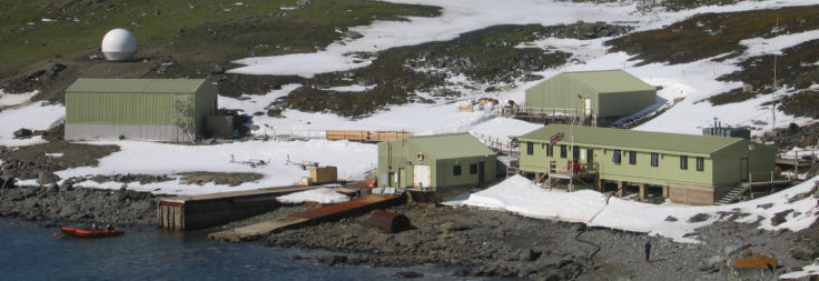
Signy Research Station, Latitude 60°43′ S, Longitude 45°36′ W, Factory Cove, Borge Bay, Signy Island, South Orkney Islands.
This image is associated with the 2005-2010 BAS science programme: DISCOVERY 2010- Integrating Southern Ocean Ecosystems into the Earth System
Scientists and support staff from BAS are due to arrive at Signy on the RRS James Clark Ross later this week (November 24) to begin the summer field season. The research station, which is home to up to 8 people when fully staffed, was empty when the earthquakes struck. Epicentres of many of the earthquakes were less than 100 miles north of the station.
Dr Rob Larter, a marine geophysicist at BAS, says,
“I understand that no one has got there yet this season, but when people do get ashore it is likely that they will find things have been shaken up a bit.”
The magnitude 7.8 event at just past 9am (GMT) yesterday morning (November 17) was the third largest earthquake worldwide this year.
The previous largest Scotia Sea earthquake was also on the northern margin of the South Orkney micro-continent (magnitude 7.6) in August 2003. That was a normal faulting (vertical displacement) movement, which can pose a risk of a tsunami.
The large events this week have all been strike-slip (horizontal displacement) movements related to Scotia-Antarctic plate motion which do not pose a significant tsunami risk. However such ‘sideways-moving’ events can destabilise adjacent segments of a fault in a sort of domino effect.
Signy Island is one of the South Orkney Islands, situated in the Southern Ocean to the north of the Weddell Sea, and approximately 900 km south-west of South Georgia. The BAS research station is uninhabited in the winter. Despite its small size it is a hive of activity in the summer months with scientists from BAS monitoring the Antarctic eco-system around the islands which includes seals and penguins.
The Scotia Sea was named in 1932 after the Scotia, an expedition ship used in these waters by the Scottish National Antarctic Expedition in 1902–04, under the leadership of William S. Bruce.