
Larsen-C Benthos
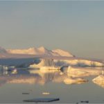
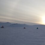
On 12 July 2017, the Larsen-C Ice Shelf calved one of the largest iceberg originating from the Antarctic Peninsula ever recorded. As iceberg A68 moves north, it leaves behind an …
Exploring the climate history and the geological structure and evolution of the rocks and mountains of Antarctica’s continental interior provides clues to past, present and future environmental change. Under-ice lakes, mountain chains buried by up to 4km ice, and sea bed sediments surrounding the frozen continent provide an unparalleled record of how the Earth’s climate has changed over millions of years.
Antarctica — our fifth largest continent — is 58-times the size of the UK. Buried beneath the snow and ice that cover more than 99% of its surface are chains of mountains the size of the Alps, while around the edge of the continent, and running across its centre, are other large mountain ranges that rise above the ice.
Geologists have studied the rocks in these mountains for more than a century. These rocks reveal that Antarctica has moved vast distances over millions of years. More than 500 million years ago, Antarctica straddled the equator, and the warm, shallow seas that covered the continent supported trilobites and other organisms long since extinct.
For hundreds of millions of years, Antarctica was locked in the centre of a giant continent called Gondwana. Around 150 million years ago, this supercontinent began to split apart, forming the modern continents of Australia, India, South America and Africa. At that time, instead of ice and snow, Antarctica was covered in dense forest and dinosaurs roamed its coastal plains.
Rocks and fossils tell us that the continent began to cool about 80 million years ago and around 35 million years ago, a vast ice sheet blanketed East Antarctica.
Locked in Antarctica’s rocks and in the sea bed around the continent is an unparalleled record of how the Earth’s climate has changed over millions of years. During the past 50 years, geologists at British Antarctic Survey (BAS) have built up the world’s largest archive of Antarctic rocks and fossils and made major contributions to our understanding of Antarctica’s ancient history.
Today, using BAS’s Royal Research Ship James Clark Ross to carry out surveys at sea and BAS aircraft to study remote corners of the continent, BAS geologists are using these ancient records to help predict how future climate change will affect not only Antarctica, but also the rest of the world.
Scientists at BAS are using advanced computer models to show what the Antarctic may have looked like 3 million years ago. The models suggest that during the mid-Pliocene warm period, the ice retreated significantly from the edges of the continent and was replaced by a sparse tundra vegetation. That a rise in temperature of only a few degrees centigrade had such a profound effect on Antarctica is a stark reminder of what might happen in the near future.
On 12 July 2017, the Larsen-C Ice Shelf calved one of the largest iceberg originating from the Antarctic Peninsula ever recorded. As iceberg A68 moves north, it leaves behind an …
The aim of this study is to investigate whether a technique developed to measure the basal meltrate of ice shelves can be used to monitor groundwater in arid and semi-arid …

DATA AS ART is an ongoing science & art project in development at NERC’s British Antarctic Survey (BAS). It visualises science data (in its widest definition), to create stunning and …
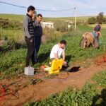
Field Team includes: Alex Brisbourne (BAS), Andrés Rivera (CECs), Rodrigo Zamora (CECs), Field Guide (BAS). Antarctic subglacial lakes contain unique records of ice sheet history and microbial life; they may …

GOCE+Antarctica- Dynamic Antarctic Lithosphere -is an international project supported by the European Space Agency (ESA) that is using GOCE satellite gravity gradient data, GPS data and innovative 3D modelling to …

The polar regions have the capacity to amaze and astound, but despite the considerable progress of recent decades we still know far less about them than less remote parts of …
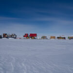
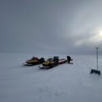
Antarctica is a unique and geographically remote environment. Field campaigns in the region encounter numerous challenges including the harsh polar climate, steep topography, and high infrastructure costs. Additionally, field campaigns …
Sea-ice is frequently cited as a likely driver and propagator of abrupt climate change because of the rapid and far-reaching impact of its feedbacks. However, numerical climate models are still …
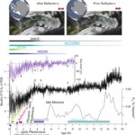
During the Last Interglacial (129-116 thousand years ago, ka) CO2 and global temperature were both higher than they were before human industrialisation. By examining Last Interglacial climate, we thus gain …
This research focuses on investigating the glacial histories of Arctic ice sheets and ice caps using the marine geological record preserved on continental margins. By reconstructing past ice sheets, their …
1 June, 2023
Concern is rising about tipping points in the Antarctic region (Armstrong et al., 2022). Recent heatwaves, changes in the Southern Ocean, and a reduction in the extent of Antarctic sea …
27 October, 2021
16 April, 2024
Scientists have discovered a landscape of rocky hills and smooth plains beneath the remote Thwaites Glacier in West Antarctica. A team of researchers used seismic imaging to map the area …
27 February, 2024
A new study, involving researchers from British Antarctic Survey, has found that significant thinning and retreat of the vast Thwaites Glacier began in the 1940s. Accelerating ice loss has been …
23 February, 2024
The final field season of the ambitious, international effort to understand Antarctica’s giant Thwaites Glacier is complete. Teams of scientists and support staff with the International Thwaites Glacier Collaboration (ITGC) …
3 February, 2024
A team have arrived at Rothera Research Station, ready to start testing the new Windracers ULTRA autonomous drone in Antarctica. If successful, the new drone platform could represent a major …
17 July, 2023
In a significant milestone for Antarctic research, detailed and extensive information on ice thickness and bed topography is now available for the first time in a centralised and standardised format. …

31 May, 2023
The ground beneath Antarctica’s most vulnerable glacier has been mapped for the first time, helping scientists to better understand how it is being affected by climate change. Analysis of the …
30 May, 2023
The West Antarctic Ice Sheet is shrinking, with many glaciers across the region retreating and melting at an alarming rate. However, this was not always the case according to new …

10 June, 2022
A new map of the seafloor of the Southern Ocean surrounding Antarctica provides the most accurate representation of this vast area to date. An international team of scientists, including several …
19 May, 2022
The latest British Antarctic Survey (BAS) Antarctic Digital Database (ADD) data will be included in a world leading collection of geographic information.
9 March, 2022
East Antarctica is the least known region of Earth. Studying this remote part of the continent is extremely difficult, requiring researchers to look beneath kilometres of blanketing ice.