Antarctica’s magnetic link to ancient neighbours
For the first time, an international team of scientists has used satellite magnetic data from ESA’s Swarm mission, together with aeromagnetic data, to help reveal the mysteries of the geology […]
GOCE+Antarctica- Dynamic Antarctic Lithosphere -is an international project supported by the European Space Agency (ESA) that is using GOCE satellite gravity gradient data, GPS data and innovative 3D modelling to study the Antarctic lithosphere and its influence on the overlying ice sheets, including the process of glacio-isostatic adjustment (GIA).
Highlights
Enhanced satellite gravity gradient images
Publishing in the Nature journal Scientific Reports –Ebbing et al (2018) present global satellite gravity curvature maps that enable new interpretations of the lithospheric setting of Antarctica.
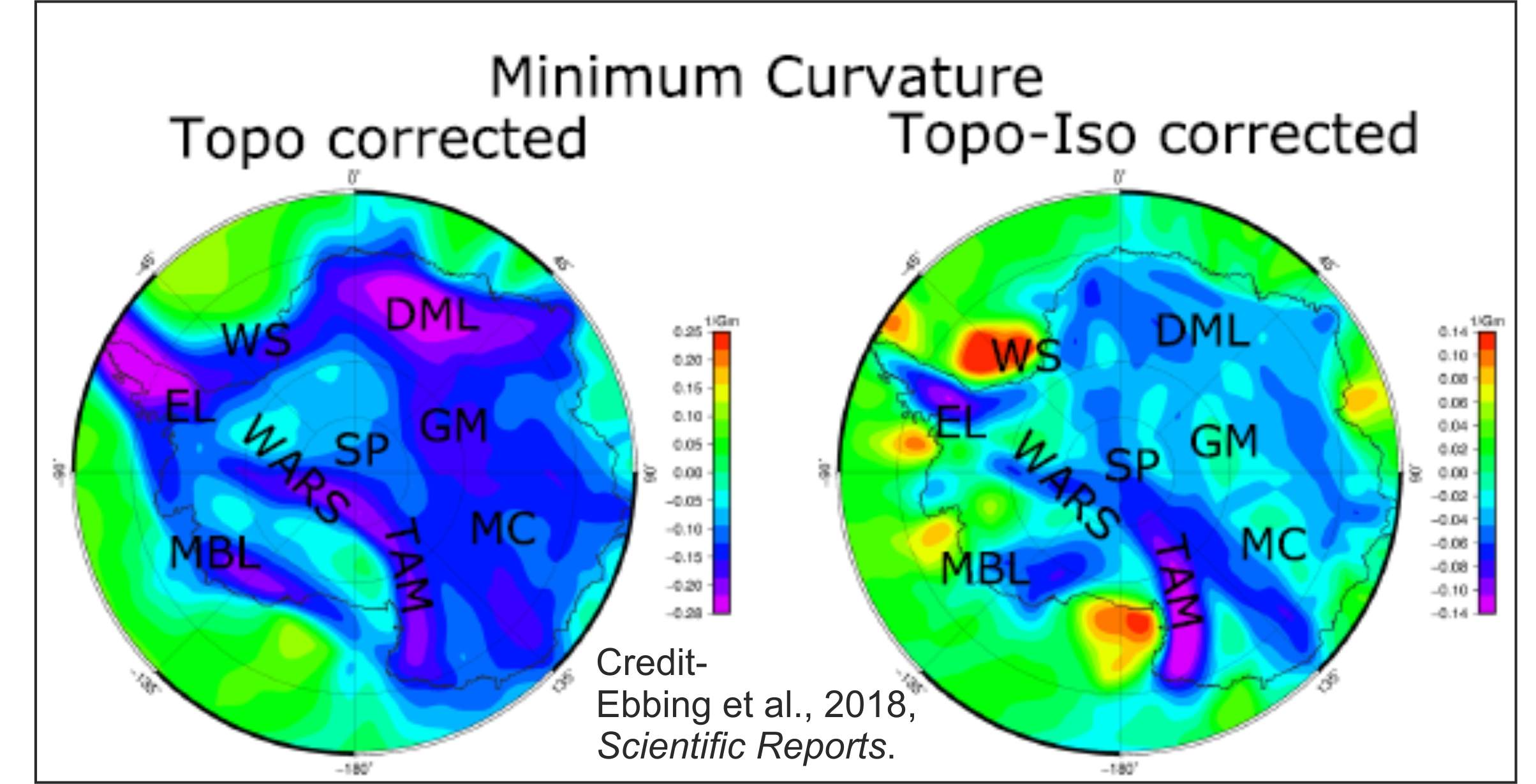
New curvature maps for Antarctica from GOCE satellite gravity.
The contrasts between the cratonic lithosphere of East Antarctica and the younger lithosphere of West Antarctica are apparent from these enhanced satellite gravity images. They also shed new light into the extent of the West Antarctic Rift System hidden beneath the West Antarctic Ice Sheet and offer new geophysical perspectives into the Marie Byrd Land hotspot.

Shape Index for Antarctica from GOCE satellite gravity.
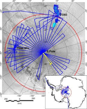
Three distinct lithospheric domains can now be recognised from their satellite gravity signatures in interior East Antarctica. One corresponds to the composite Mawson Craton; another overlies the Tonian Oceanic Arc Superterrane in interior Dronning Maud Land; a currently less-well understood third province likely marks a cratonic margin region between the Weddell Sea and South Pole. This frontier is also being investigated in the ESA PolarGAP project, which also helps fill the data void in GOCE south of 83°S.
Plate tectonic animation from 200 Ma to present and Shape Index from GOCE
The “shape index” derived from satellite gravity for Antarctica and other continents were placed into a plate reconstruction. This provides new views of the similarities and the contrasts in lithospheric architecture and tectonic processes between Antarctica and formerly adjacent continents (Australia, Zelandia, South America, Africa and India) within Gondwana.
Rapid bedrock uplift beneath the West Antarctic Ice Sheet in the Amundsen Sea Embayment
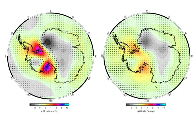
Publishing in Science -Barletta et al (2018) show that the viscosity of the mantle under the Amundsen Sea Embayment – the mostly rapidly changing sector of the West Antarctic Ice Sheet- is particularly low and this explains the remarkably rapid bedrock uplift rates observed.
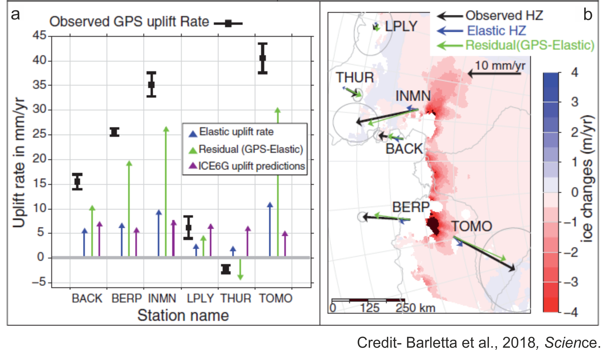
Observed bedrock motions (a) and West Antarctic ice sheet changes (b).
The marine portion of the West Antarctic Ice Sheet in the Amundsen Sea Embayment is a major contributor to global sea-level rise and is vulnerable to catastrophic collapse. But what is the role of the Solid Earth and in particular bedrock motion in modulating ice sheet retreat?
New GPS data reveal extremely rapid, up to 41 millimeters per year, bedrock uplift in the region, one of the fastest GIA-related uplift rates ever recorded. This could potentially slow down future grounding line retreat of Thwaites and Pine Island Glacier.
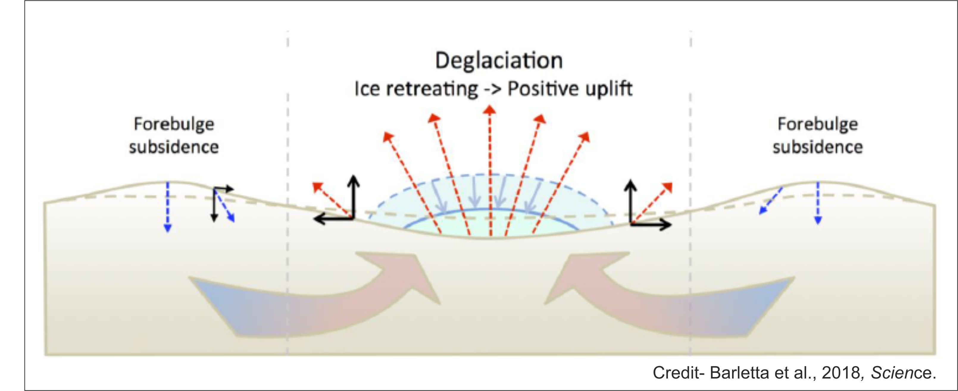
Schematic showing Solid Earth deformation caused by ice sheet changes.
Over 800 Earth models with about 10,000 variations of these models were combined with different scenarios of ice sheet history. By comparing the residual with predictions from viscoelastic modelling, a viscosity range for the shallow upper mantle between 1018 and 6.3 × 10¹⁸ Pa s was found to best fit the remarkably high uplift rates observed.
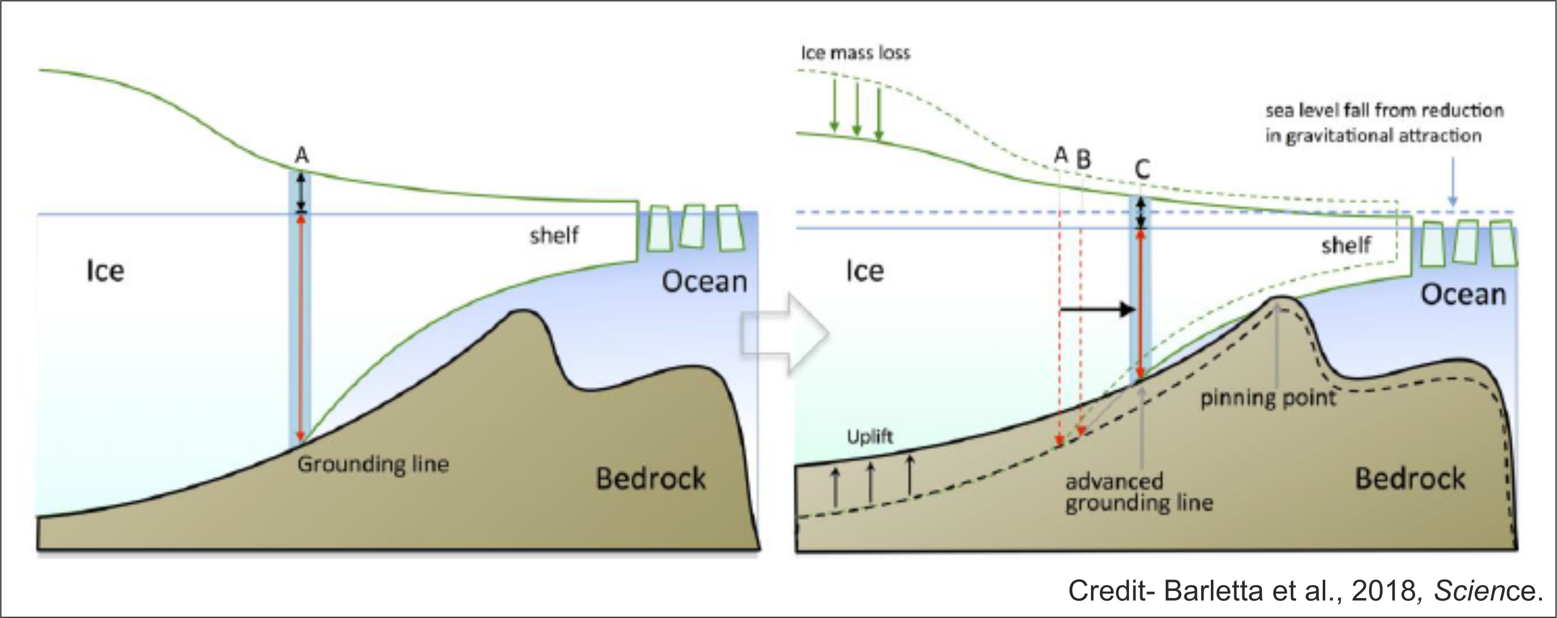
Grounding line migration and bedrock uplift.
Such low viscosity is likely linked to the hot upper mantle beneath parts of the West Antarctic Rift System, as suggested by seismological models and an elevated geothermal heat flux. The low viscosity in deeper layers may be related to a mantle plume, such as hypothesized in Marie Byrd Land. However, a mantle chemically altered by protracted Paleozoic-Cretaceous subduction along the former West Antarctic active margin also helps explain the low viscosity.
Current 3D modelling
PhD student Pappa (Univ. of Kiel) and his co-workers are finalising their efforts to combine modelling of GOCE satellite gravity data with independent seismological constraints and petrological and thermal modelling to derive a new 3D model of the Antarctic lithosphere.
The results provide new insights on crustal thickness variations beneath East and West Antarctica and the depth of the Lithosphere-Asthenosphere Boundary (LAB). Important new constraints on the thermal structure of the lithosphere, with implications for our understanding of the controls on upper mantle viscosity and geothermal heat flux variations are emerging. This is particularly important in the quest to better comprehend Solid Earth influences on the dynamics of the Antarctic ice sheets, including processes such as GIA.
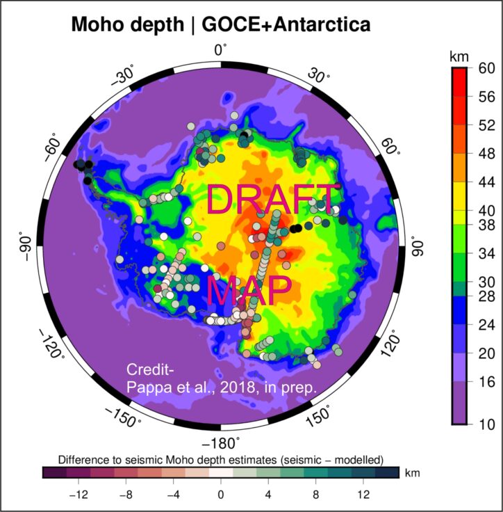
Map showing the best-fit Moho (crust-mantle) depth estimate for Antarctica from inversion of satellite gravity data and the differences with previous seismically-derived estimates.
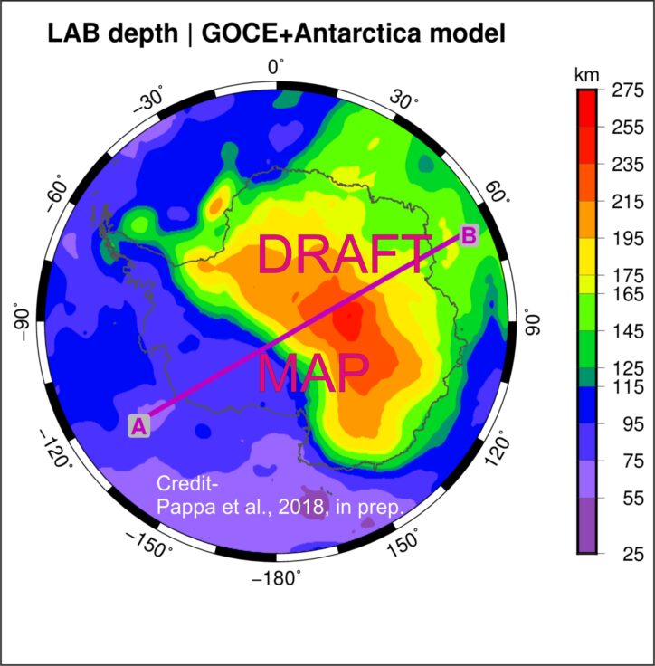
Map showing the best-fit depth estimate for the Lithosphere-Asthenosphere Boundary (LAB). Note the location of the profile in next image.
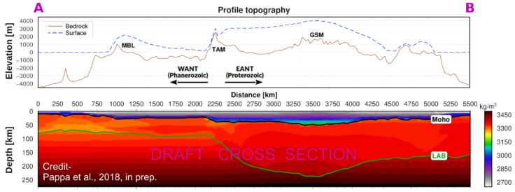
Profile view extracted from the new 3D model showing the contrast in crustal and lithosphere thickness between West and East Antarctica and variations in both density structure and architecture.
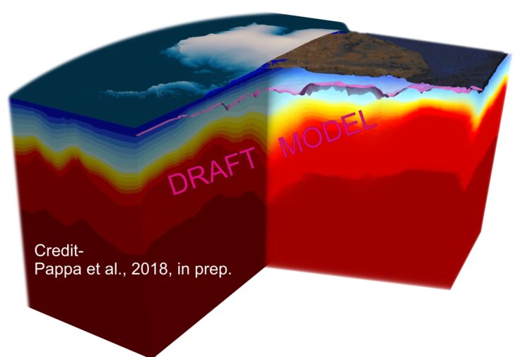
3D view of the new thermal model for the Antarctic lithosphere.
GIA modelling
Viscosity can be computed using a stress-strain rate relationship. For this a creep law for olivine is selected, which is assumed to be the material that governs deformation in the upper mantle. Using the temprature in the figure above, viscotiy maps, shown below, were calculated for dry olivine with 4 mm grain size. High viscosity in East Antarctica result in a thick effective viscosity there.
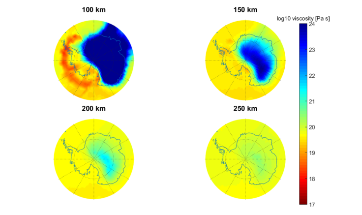
Viscosity map at different depths for the temperature model (credit to Wouter van der Wal)
Uplift rates are predicted with a 3D GIA model for the viscosity model for different creep parameters and ice loading model of Whitehouse et al (2012). Both large and small viscosity can result in a lower uplift rates. The figure below shows the effect of a weaker rheology which leads to subdued uplift rates.
Uplift rates for the temperature model in figure 5 and creep parameters for dry and 4 mm grain size olivine (left) and wet olivine of 10 mm grain size (right). (credit to Wouter van der Wal)
PhD student Blank (Delft University of Technology) developed a new GIA model which has higher resolution in Antarctica (see figure below). This allows studying smaller scale signals in Antarctica related to recent ice melting, in combination with low viscosity. The model has been benchmarked with tests shown in Martinec et al. (GJI, 2018)
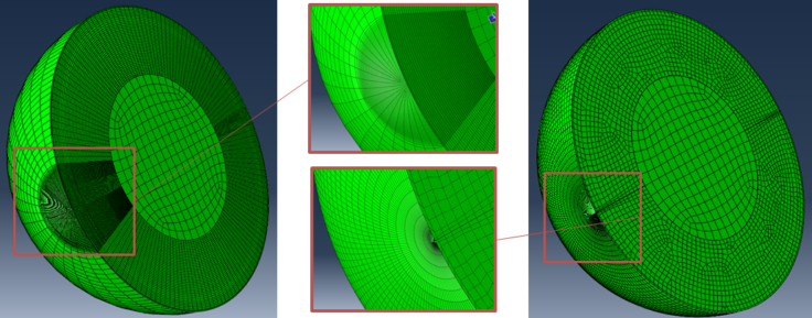
Finite-element mesh for the new model (left) vs a model with the mesh characteristics of the old model (right). (credit to Wouter van der Wal)
1) studies of the structure of the lithospheric cradle on which Antarctic ice sheets flow;
2) new assessments of how lithospheric processes influence bedrock topography;
3) increased knowledge of the interactions between the Solid Earth and the overlying Antarctic ice sheets, in particular GIA processes.
This project promises to shed fundamental new light into deep structures beneath Antarctica. By addressing how the deeper Solid Earth influences ice sheet behavior it will also impact on our ability to comprehend and predict how these affect both present and future sea-level rise.
The GOCE+Antarctica project involves a research team from several European Universities and research institutions and can be subdivided into six main components:
1) Review of Antarctic lithosphere studies (including seismological, airborne geophysical, satellite gravity and xenolith studies);
2) Geophysical data assembly;
3) Bedrock topography studies;
4) Crust and lithosphere modelling;
5) GIA modelling and analysis;
6) Presentations, publications and outreach activities.


Folker Pappa PhD Student


Rene Forsberg Professor, Head of Geodynamics

Valentina Barletta Postdoc

Tim Jensen Postdoc
![]()
Wouter van der Wal Assistant Professor – Planetary Exploration, Astrodynamics and Space Missions group
![]()
Bas Blank PhD Student
For the first time, an international team of scientists has used satellite magnetic data from ESA’s Swarm mission, together with aeromagnetic data, to help reveal the mysteries of the geology […]
Unveiling key geological features of the Earth’s lithosphere
Revealing Antarctica’s hidden world
Publications
Barletta, V.R, Bevis, M., Smith, B.E., Wilson, T., Brown, A., Bordoni, A., Willis, M., Khan, S.A., Rovira-Navarro, M., Dalziel, I., Smalley, Jr. R., Kendrick, E., Konfal, S., Caccamise II, D.J., Aster, R.C, Nyblade, A, Wiens, D.A, (2018). Observed rapid bedrock uplift in Amundsen Sea Embayment promotes ice-sheet stability, Science 360, 6395, pp 1335-1339; DOI: 10.1126/science.aao1447.
Ebbing, J., Haas, P., Ferraccioli, F., Pappa, F., Szwillus W., and Bouman J., (2018). Earth tectonics as seen by GOCE – Enhanced satellite gravity gradient imaging. Scientific Reports, 8:16356; DOI: 10.1038/s41598-018-34733-9.
Hermans, T. H. J., van der Wal, W., & Broerse, T., (2018). Reversal of the direction of horizontal velocities induced by GIA as a function of mantle viscosity. Geophysical Research Letters, 45. https://doi.org/10.1029/2018GL078533.
Martinec, Z., Klemann, V., van der Wal, W., Riva, R E M , Spada, G., Sun, Y., Melini, D., Kachuck, S.B., Barletta, V., Simon, K., James, G.A.T.S., (2018). A benchmark study of numerical implementations of the sea level equation in GIA modelling, Geophysical Journal International, 215, 1(1), 389–414, https://doi.org/10.1093/gji/ggy280.
Presentations
ESA’s Earth Observation Toolkit
Kick-off meting GOCE+ Antarctica Dynamic Antarctic lithosphere
Conference Abstracts
2018
Barletta VR, Bordoni A, Non-Linear GIA correction for GRACE-derived mass balance in low viscosity regions. EGU, Vienna, 2018.
Bredow, E., Ebbing, J., Pappa, F., Barletta, V., Ferraccioli, F., van der Wal, W., Bouman, J., Steinberger, B., Geodynamic modelling of the West Antarctic mantle – rift or plume dominated? POLAR18, Davos 2018.
Ebbing, J., Macelloni, G., Kern, M., Ferraccioli, F., Pappa, F., Satellite estimates of the Antarctic heat. EGU 2018.
Ferraccioli, F., Ebbing, J., Pappa, F., Forsberg, R., Kern, M., Antarctic lithospheric provinces imaged with satellite gravity gradient and airborne gravity data. EGU 2018.
Ferraccioli, F., Ebbing J. Devil in the detail: enhanced imaging of Antarctic crustal and lithospheric provinces to aid future geothermal heat flux estimation. Taking the Temperature of the Antarctic Continent Workshop 2018.
Ferraccioli, F., Ebbing, J., Pappa, F., Kern, M., Forsberg, R., Satellite gravity gradient imaging of the Antarctic lithosphere. POLAR 2018, Davos.
Ferraccioli, F., Ebbing, J., Pappa, F., Kern, M., Forsberg, R., T.A Jordan, Recent satellite and airborne geophysical imaging of the Antarctic lithosphere, UK Antarctic Conference 2018, Durham.
Haas, P., Gaina, C., Ebbing, J., Unveiling signs of old supercontinents by satellite gravity gradients and curvature attributes with special focus on Antarctica. EGU 2018.
Pappa, F.; Ebbing, J.; Ferraccioli, F.; van der Wal, W.; Blank, B., Integrated 3D lithosphere model of Antarctica. Abstract for POLAR18, Davos 2018.
Pappa, F., Macelloni, G., Kern, M., Ferraccioli, F., Ebbing, J. – Taking the temperature of Antarctica with satellites. Taking the Temperature of the Antarctic Continent Workshop 2018.
Pappa, F., Ebbing, J., Ferraccioli, F., Van der Wal, W., Blank, B., A 3D lithospheric model of Antarctica and its implications on mantle viscosity. EGU 2018.
van der Wal, Pappa,F., Egbrink, D.E., Ebbing, J., GIA model for Antarctica with 3D viscosity estimates based on seismology and gravity. EGU 2018.
Wansing, A., Ebbing, J. – Combined modelling of satellite and airborne magnetic data for East Antarctica. 27. Internationale Polartagung, Rostock, 2018.
2017
Martinec, Z. et al (W. van der Wal, B. Blank), A benchmark study of the sea-level equation in GIA modelling, EGU, Vienna, 2017
Ebbing, Jörg; Pappa, F.; Barletta, V., Blank, B., Ferraccioli, F., Forsberg, R., Kern, M., v.d. Wal, W., The influence of the Antarctic lithosphere on glacial isostatic adjustment modelling. IAG-IASPEI, Kobe, Japan, 2017.
Ebbing, J., Ferraccioli, F., Pappa, F., Kern, M., Forsberg, R., Satellite gravity gradient views help reveal the Antarctic lithosphere. AGU Fall Meeting, 2017.
Pappa, F., Ebbing, J., Ferraccioli, F., van der Wal, W., 2017. Detecting the ancient cores of Antarctica in a new integrated lithospheric model. EGU, 2017.
Ferraccioli, F. , Ebbing, J., Pappa, F., Kern, M., Forsberg, R., 2017. The lithosphere of the Antarctic continent: new insights from satellite gravity gradient data. EGU 2017.
Ferraccioli, F., Seddon S., Finn C.A., Wu. G., Bell. R.E., Jordan T.A., 2017. Imprints of a Pan-African transpressional orogen superimposed on an inferred Grenvillian accretionary belt in central East Antarctica. EGU, 2017.
Ferraccioli, F. T.A. Jordan, R. Forsberg, A.V. Olesen, G. Eagles, K. Matsuoka, T. Casal, 2017. New aerogeophysical views of the South Pole Frontier. International Workshop “Airborne Geodesy and Geophysics with Focus on Polar Applications“ Dresden, 19-21 April 2017.
Ferraccioli, F., Seddon S., Finn C.A., Wu. G., Bell. R.E., Jordan T.A., 2017. Airborne geophysics images a Pan-African transpressional orogen superimposed on a Grenvillian accretionary belt in central East Antarctica, International Workshop “Airborne Geodesy and Geophysics with Focus on Polar Applications“ Dresden, 19-21 April 2017.
Pappa, F., Ebbing, J., Ferraccioli, F., van der Wal, W., 2017. Antarctica’s lithosphere revealed in an integrated 3D density model. 77. Jahrestagung der Deutschen Geophysikalischen Gesellschaft, Potsdam.
Hartmann, R., Pappa, F., Ebbing, J., 2017. Effekt mariner und kontinentaler Sedimentbecken auf die Schweregradienten in der Antarktis. 77. Jahrestagung der Deutschen Geophysikalischen Gesellschaft, Potsdam.
Ebbing, J., Pappa, F., Barletta, V., Blank, B., Ferraccioli, F., Forsberg, R., v.d. Wal, W., Kern, M., Linking GIA and Lithospheric Structure of Antarctica with Satellite Gravity Gradients. Fourth Swarm Science Meeting, Banff, Canada.
Blank, B., Hu, H., van der Wal, W., Pappa, F., Ebbing, J., 2017. Finite-element GIA Estimations For Antarctica Based On A New Lithospheric Model. North-American CryoSat Science Meeting. Banff, Canada.
Blank, B., Van der Wal, W., Pappa, F., and Ebbing, J., A 3D Finite Element Model with Improved Spatial Resolution to Investigate the Effect of Varying Viscosity on Antarctica. AGU Fall Meeting 2017.
Hermans, T.J., W. van der Wal, S. Konfal, F. Pappa, Workshop on Glacial Isostatic Adjustment and Elastic Deformation, Reykjavik, 5-7 september 2017.
Pappa, F., Ebbing, J., Ferraccioli, F., van der Wal, W., Blank, B., An integrated 3D model of Antarctica’s lithosphere as a basis for cryospheric modelling. Workshop on Glacial isostatic adjustment and elastic deformation, Reykjavik, Iceland, September 5 – 7, 2017.
Pappa, F., Ebbing, J., Ferraccioli, F., Isostatic Implications of Different Seismic and Gravity Derived Moho Depths for Antarctica. AGU Fall Meeting, 2017.
van der Wal, W., P. Vizcaino Rubio, B. de Boer, R. van de Wal, D. Oude Egbrink, Effect of laterally varying bedrock relaxation time on ice sheet growth, Workshop on Glacial Isostatic Adjustment and Elastic Deformation, Reykjavik, 5-7 September 2017.
van der Wal, W., Vizcaino Rubio, P., De Boer, B., van de Wal, R.S.W., Ice sheet growth with laterally varying bedrock relaxation time, EGU, Vienna 2017.
2016
Barletta, V.R., Bordoni, A., Bevis, M.G., Wilson, T.J., Rovira, M., 2016. Sensitivity of modeled rapid bedrock displacement in the Amundsen Embayment sector. AGU Fall Meeting, San Francisco.
Ferraccioli, F. , Bell, R.E., Blankenship, D.D., Young, D.A., Eagles, G., Forsberg, R., Armadillo, E., Aitken, A., Jacobs, J., Seddon, S., Jordan, T.A., Golynsky, S., Ebbing, J., Finn., C., Dalziel, I.W.D, 2016. Revealing the crustal architecture of the least understood composite craton on Earth: East Antarctica. AGU Fall Meeting, San Francisco, 2016.
Forsberg, R., Olesen, A.V., Jordan, T., Ferraccioli, F., Matsuoka, K., – Airborne geophysical surveys of unexplored regions of Antarctica – results of the ESA PolarGap campaign. AGU Fall Meeting, San Francisco, 2016.
Pappa, Folker; Ebbing, Jörg; Ferraccioli, F., Wal, W.v.d., Barletta, V., 2016. Deciphering the changes in the lithospheric structure of Antarctica by combining seismological and satellite gravity gradient data. AGU Fall Meeting, San Francisco, 2016.
Whitehouse, P., van der Wal, W., King, M., The importance of considering lateral variations in mantle rheology when investigating past and present Antarctic Ice Sheet change (Invited), AGU Fall Meeting, San Francisco, 2016.
Ebbing, J., 2016. From space under the ice. Invited talk at Geological Survey of Norway, October 20th 2016.
Forsberg, R., Olesen, A.V., Jordan, T., Ferraccioli, F., Matsuoka, K., Airborne geophysical survey of the GOCE polar gap in Antarctica. IAG Symposium on Gravity, Geoid and Height Systems, Thessaloniki, Greece, Sep 2016.
Ferraccioli, F., Ebbing, J., Bouman, J., Pappa, V., Kern, M., Forsberg, R., Barletta, V., Martos, Y. , Root, B., van der Wal, W., 2016. Satellite gravity gradient and airborne gravity views of the Antarctic lithosphere. International Geological Conference, Cape Town, Sept. 2016.
Ebbing, Jörg; Bouman, Johannes, Ferraccioli, Fausto; Kern, Michael; Barletta, Valentina; Forsberg, Rene; Pappa, Folker; Root, Bart; v.d. Wal, Wouter, 2016. Seeing beneath the ice with satellites – the dynamic Antarctic lithosphere. SCAR August 2016, Kuala Lumpur.
Whitehouse, P., van der Wal, W., Using 3D Glacial Isostatic Adjustment models to determine the regional sensitivity of the solid Earth to past ice mass change. SCAR meeting August 2016, Kuala Lumpur.
Ebbing, J., 2016. Dynamic Antarctic lithosphere. Invited talk at Geophysical Seminar, University of Hamburg, June, 20th 2016.
Ebbing, Jörg, Ferraccioli, Fausto; Haagmans, Roger; Kern, Michael; Barletta, Valentina; Forsberg, Rene; Pappa, Folker; v.d. Wal, Wouter; Root, Bart; Bouman, Johannes. GOCE+Antarctica: Dynamic Antarctic lithosphere. ESA Living Planet Symposium 2016, Prague.
Ebbing, Jörg, Pappa, Folker; Szwillus, Wolfgang, 2016.- Curvature analysis of satellite gradients – A meaningful tool for tectonic interpretation? EGU General Assembly 2016, Vienna.
Pappa, Folker; Ebbing, Jörg; Haas, Peter; Rabbel, Wolfgang , 2016- Satellite gravity gradients to study the lithosphere – Case examples from Antarctica and the Tornquist Zone. ESA Living Planet Symposium 2016, Prague.
Pappa, Folker; Ebbing, Jörg; Haas, Peter, 2016. – Analyse von Satelliten-Schweregradienten als Grundlage zur Entwicklung eines Lithosphären modells des antarktischen Kontinents. 76. Jahrestagung der Deutschen Geophysikalischen Gesellschaft e.V., Münster 2016
Key References (GOCE+ Antarctica researchers in bold)
Bouman J., Ebbing J., Fuchs M., Sebera J., Lieb V., Szwillus W., Haagmans R., Novak P., 2016. Satellite gravity gradient grids for geophysics. Nature Scientific Reports, 6:21050, 10.1038/srep21050, 2016 (Open Access).
Scheinert M., Ferraccioli F., Schwabe J., Bell R., Studinger M., Damaske D., Jokat J., Aleshkowa N., Jordan T.A., Leitchenkov G., Blankenship D.D., Damiani T.M., Cochran J.R., Richter T.D., 2016. New Antarctic Gravity Anomaly Grid for Enhanced Geodetic and Geophysical Studies in Antarctica. Geophysical Research Letters doi:10.1002/2015GL067439.
Bouman J., Ebbing J., Meekes S., Fattah R.A., Fuchs M., Gradmann S., Haagmans R., Lieb V., Schmidt M., Dettmering D., Bosch W., 2015. GOCE gravity gradient data for lithospheric modeling. International Journal of Applied Earth Observation and Geoinformation 35(A): 16-30, Elsevier, 10.1016/j.jag.2013.11.001.
van der Wal, Wouter, Whitehouse, Pippa L. & Schrama, E.J.O, 2015. Effect of GIA models with 3D composite mantle viscosity on GRACE mass balance estimates for Antarctica. Earth and Planetary Science Letters, 414:134-143.
Bouman J., Fuchs M., Ivins E., van_der_Wal W., Schrama E., Visser P., Horwath M., 2014. Antarctic outlet glacier mass change resolved at basin scale from satellite gravity gradiometry. Geophysical Research Letters 41(16): 5919-5926, 10.1002/2014GL060637.
Ebbing J., Bouman J., Fuchs M., Lieb V., Haagmans R., Meekes J.A.C., Fattah R.A., 2013. Advancements in satellite gravity gradient data for crustal studies. The Leading Edge 32(8): 900-906, Society of Exploration Geophysicists, 10.1190/tle32080900.1.
Bingham, R.G., Ferraccioli, F., King, E.C., Larter, R.D., Pritchard, H.D., Smith, A.M. & Vaughan, D.G., 2012. Inland thinning of West Antarctic Ice Sheet steered along subglacial rifts. Nature, 487, 468-471. DOI: 10.1038/nature11292.
Ferraccioli, F., Finn, C. A., Jordan, T.A., Bell, R.E., Anderson, L.M., Damaske, D., 2011. East Antarctic Rifting Triggers Uplift of the Gamburtsev Mountains. Nature, 479, 388-392, doi:10.1038/nature10566.
Discover the UK’s national capability to support science from the air