The latest British Antarctic Survey (BAS) Antarctic Digital Database (ADD) data will be included in a world leading collection of geographic information.
The ADD is a compilation of the best available topographic data for Antarctica. It is managed by BAS’ Mapping and Geographic Information Centre (MAGIC) on behalf of The Scientific Committee on Antarctic Research (SCAR) and is an essential tool for researchers navigating and understanding Antarctica’s everchanging landscape.
This week, the ADD has been made even more accessible through the inclusion of its coastline and contour datasets in the ArcGIS Living Atlas of the World. This globally recognised collection of geographic information contains data from a range of leading contributors and organisations and is accessed by over 10 million users internationally. It is hoped that this collaboration between BAS and ArcGIS will help to bring BAS’ unique knowledge of Antarctica to the wider research community and further international polar research efforts.
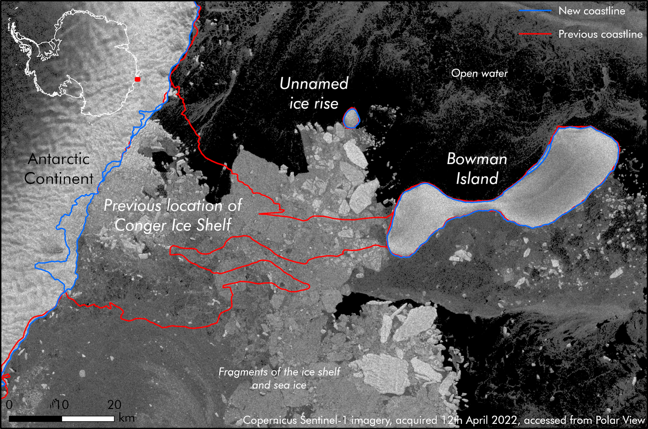
Topographic map of the recently collapsed Conger Ice Shelf contained in the latest edition of the ADD.
Antarctica is constantly evolving with ice shelves growing and calving on a regular basis, and the retreat of ice revealing hidden features underneath. The ADD is updated every six months to capture all of these changes and to ensure reliable and up-to-date information is available to the science and logistics communities.
The main changes to the latest version of the ADD are to the coastline and large areas of ice shelves including updates to:
- the entire coast of Dronning Maud Land
- the Brunt Ice Shelf where BAS’s Halley Research Station is located
- other important areas such as the Ronne-Filchner Ice Shelf and the Conger Ice Shelf.
Other smaller changes include the addition of some islands in the Rhyolite Islands group, in George VI Sound. These islands have always existed but have not been mapped before. With the ever-increasing amount of freely available satellite imagery, more of these unmapped locations can now be accurately mapped to aid scientific research and operational activities in Antarctica.
Laura Gerrish, Geographic Information Systems and Mapping Specialist with the BAS MAGIC team, says:
“We are always proud to announce the latest updates to the ADD and to help build a picture of this dynamic and changing part of the world. Unlike normal updates though, this time we are also publishing datasets to ESRI Esri ArcGIS Living Atlas, which will increase their visibility and reach. It’s exciting to think how this might advance our understanding of the polar regions.”
The ADD is accessible via the ADD data catalogue and can now be used directly within ArcGIS desktop applications, and via Esri ArcGIS web services.
The coastlines and contours can be seen on BAS’ profile on the Living Atlas of the World site.
The ADD is an international product and we welcome contributions from external organisations. The continent is a vast area, and it takes a team effort to keep the data up to date. If you have data to contribute, please contact us on magic@bas.ac.uk