Marine Mammal Scientist
Wildlife from Space
Wildlife from Space
Many populations of wildlife are remote, inaccessible or difficult to monitor. The advent of sub-metre, Very-High-Resolution (VHR) satellite imagery may enable us study these animals in a much more efficient way.
Over the past decade, BAS scientists have led investigations using satellite technology to identify, count and monitor different species in Antarctica and elsewhere. We have tested the capability of new satellites, applied bespoke methods to different species and developed automated counting techniques using Artificial Intelligence. These innovative developments have led to breakthroughs in the understanding of distribution and population trends, and increased uptake of the new technology by many other institutions and academics.
The main groups of animals on which we have focussed are:
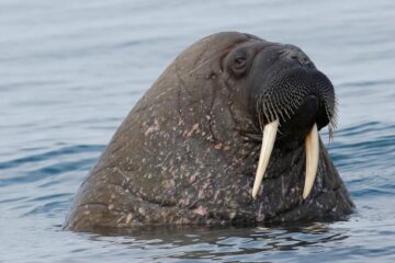
Walrus from Space
Walrus are facing the reality of the climate crisis and we need to know more about how they are affected. British Antarctic Survey (BAS) and WWF (Worldwide Fund for Nature) are asking the public to become ‘walrus detectives’ and help contribute to conservation science by searching for walrus in the thousands of satellite images taken from space.
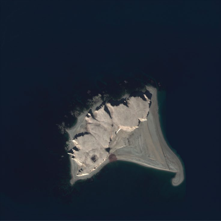
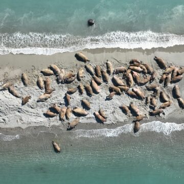
Example of a satellite image of an Atlantic walrus haul-out. From space they look like small or large groups of reddish or pale brown shapes that can be next to each other or a few meters away. This satellite image is 1.87 km². On the Walrus from Space platform (the Geohive app) users will view images cropped to 0.04 km². Satellite imagery © 2021 Maxar Technologies
Over 5 years the project, which is in cooperation with scientists around the Arctic, aims to carry out the first ever whole population census of Atlantic and Laptev walrus using satellite imagery and explore what might happen to them in the context of rapid climate change. This will help scientists to better understand the impact of climate change on populations of this iconic species and help safeguard their future. Sign up to take part here.
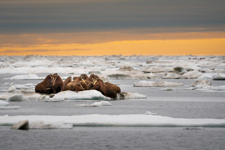
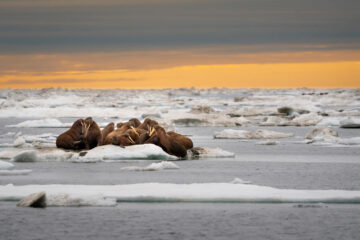
A herd of walruses (Odobenus rosmarus) on an ice floe. Svalbard, Norway. Image © 2018 Richard Barrett
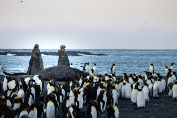
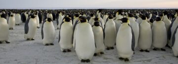
Penguins
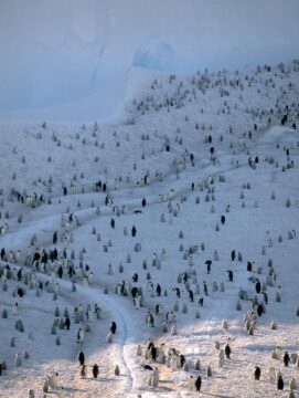
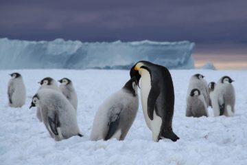
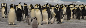
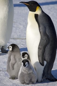
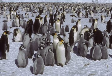
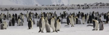
In the remote and inhospitable landscape around the Antarctic coastline, penguins can be challenging to monitor. For a decade, BAS has been locating, counting and studying colonies of emperor penguins to investigate the effects of climate change using vVHR satellite imagery. This work included the first global survey of a species from space (2012) and the discovery of many new breeding colonies. Since 2013, BAS has collaborated with WWF to monitor emperor colonies in a sector between 0° and 90°E. This includes sixteen breeding sites. Some of these have experienced dramatic changes in population sizes over time.
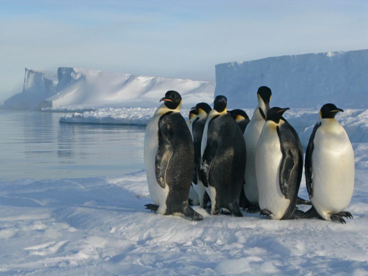
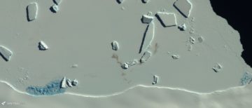
Emperor penguins (Aptenodytes forsteri) on sea ice at the Brunt ice shelf.
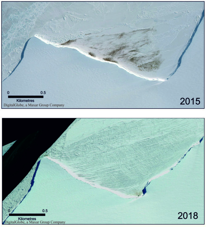
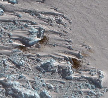
Satellite imagery showing the reduction in size of the Halley Bay colony in 2018 compared with 2015
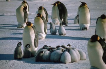
We have also used satellites to locate colonies and determine population trends of the smaller Pygoscelis penguins, such as chinstrap, Adélie and gentoo penguins. We used the unique spectral signature of guano to identify the breeding sites. Interestingly, the guano changes colour over the season, so as different species breed at different times we can tell the species by the colour of the guano at the time of the imagery.
Tracking populations from space has led to the threat status of emperor penguins being changed from “Least concern” to “Near Threatened” by the International Union for Conservation of Nature (IUCN) in 2012, and has stimulated political discussion of Emperor penguin protection and climate change. The work on the impact of low sea ice on Emperor penguin populations has led to efforts to list them as a Specially Protected Species.
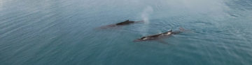
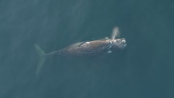
Whales
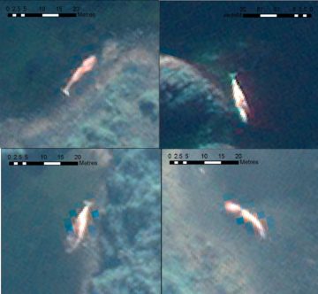
Many whale species were brought to the verge of extinction in the age of commercial whaling, but since then some populations have started to recover. These species still face many threats, including ship strikes, pollution, entanglement and disease. Populations are difficult to assess by traditional means so BAS has led the study of baleen whales by satellite, a technology that could revolutionize how we monitor these animals.
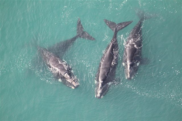
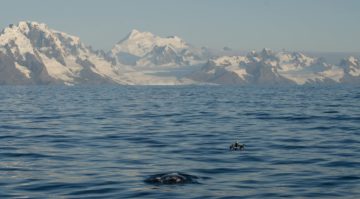
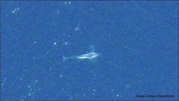
A pod of southern right whales
We have tested the applicability of VHR satellites to identify and count several species (including humpback, sei, blue, southern right, grey and fin whales), analysed their reflectance (how easy they are to detect), developed automated counting techniques and examined how to convert satellite counts to abundance estimates. We have also investigated the use of satellites to identify and count stranded whales. Our research has led to the International Whaling Commission recommending a number of locations around the globe where use of the technology should be prioritized.
Seals
The sea ice that surrounds Antarctica is home to several species of seal that depend on it throughout their lives for resting, breeding, protection against predators and access to food. The vast size and dynamic nature of this frozen sea makes counting these seals incredibly challenging so that at present know little about how many there are and how their populations are coping with challenges such as climate change. We need to understand more about these seals as they are very important to the Antarctic Ecosystem. For example, crabeater seals are the most numerous seal in the world but at present we can only estimate their abundance as somewhere between 7 and 75 million individuals. Given they eat around 20kg of krill a day they have a large impact on the foodweb. Weddell seals, the second most abundant seal, like to live deep within the sea ice close to the Antarctic Continent making them very difficult and expensive to access and count.
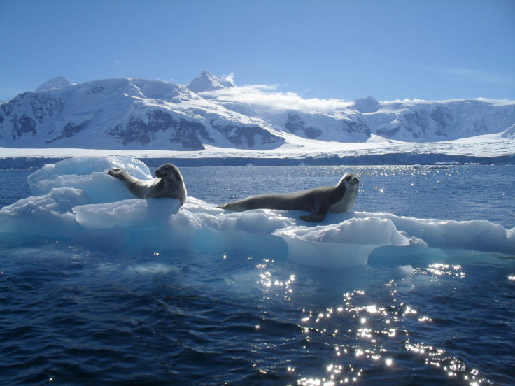
Crabeater seals on an iceberg, taken on a boat trip from Rothera Research Station.
As part of the international Censusing Animal Populations from Space project, BAS is using VHR satellite images to study these ice seals. We are developing new methods to automatically detect and count seals, and classify the different environments they live in, including automated counting using machine learning and Artificial Intelligence combined with thermal imaging and spectral analysis.
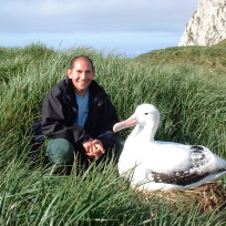
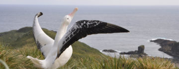
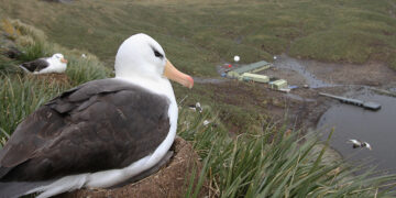
Albatross
The great (Diomedea) albatrosses are the largest flying birds on Earth and they live on remote, inaccessible islands around the Southern Ocean. These charismatic birds face a number of threats including incidental mortality (bycatch) from longline fishing, invasive species, disease and habitat destruction.

All of the great albatross species are threatened with extinction (https://www.iucn.org/) so monitoring their populations is critical. Survey of their remote breeding sites is difficult, so we are developing methods to automatically count and census albatrosses using VHR satellite imagery. In 2014, we conducted the first census of a whole population by satellite, when we counted all colonies of northern royal albatrosses in a single breeding season.
- Combine the expertise remote sensing expertise of the Mapping and Geographic Information Centre (MAGIC) with the BAS Ecosystems team to deliver innovative, impactful and world-leading science outputs
- To provide innovative world-leading solutions to provide answers and advice to key conservation questions for policy-makers, government and international stakeholders on wildlife populations using remote sensing methods
- To develop techniques and methods that facilitate the finding, monitoring and understanding of polar wildlife and, where appropriate, to transfer this knowledge to other similar challenges globally
Information gained from these remote approaches help inform international initiatives such as the IUCN Red List assessments of threat status for polar wildlife.
-

-

Geographic Information Officer
-

Molecular Ecologist/Whale biologist
-
Seabird Ecologist Deputy Science Leader IMP 3
-

Wildlife from Space Research Associate
-

Marine Ecologist
-

PhD Student
-

Scientist - Other
-
7 things you didn’t know about poo in Antarctica
Read more of: 7 things you didn’t know about poo in AntarcticaPoo isn’t usually what first comes to mind when thinking of Antarctica, we tend to imagine the frozen landscape, vast expanses of white, ice sheets, and penguins. Yet, poo is […]
-
How many penguins are in Antarctica?
Read more of: How many penguins are in Antarctica?No, it’s not a Penguin joke! This World Penguin Day (25 April 2023) we spoke to some of our resident experts, Mike Dunn and Peter Fretwell, to find out more […]
-
PODCAST – Iceworld, Episode 5 – Seals from Space
Read more of: PODCAST – Iceworld, Episode 5 – Seals from SpaceEpisode 5: Seals from Space In Episode 5 of Iceworld, Rob Taylor is joined by Prem Gill who has just completed two weeks of fieldwork as part of his PhD […]
-
Happy World Walrus Day 2024
Read more of: Happy World Walrus Day 2024From their unmistakable tusks to their characteristic bristles (the envy of many a ‘Movember’ moustache!), the walrus is one of the Arctic’s most iconic species, and today (Sunday 24 November) is World Walrus Day!
-
Drones and images from space count elephant seals
Read more of: Drones and images from space count elephant sealsA team of researchers are using drones and satellite images from space to count southern elephant seals on the sub-Antarctic Island of South Georgia.
-
Drones validate walrus counts in satellite images from space
Read more of: Drones validate walrus counts in satellite images from spaceIn the first successful attempt to calibrate walrus counts from satellite imagery, scientists used drones to validate animal counts in Svalbard, Norway.
-
‘Penguin detectives’ required for new counting app
Read more of: ‘Penguin detectives’ required for new counting appBritish Antarctic Survey (BAS) is inviting the public to become ‘penguin detectives’ and spend five minutes counting emperor penguins to help with vital research into these iconic animals.
-
Emperor penguin colonies in Antarctica suffer as sea-ice diminishes
Read more of: Emperor penguin colonies in Antarctica suffer as sea-ice diminishesRecord low levels of Antarctic sea-ice in late 2023 resulted in breeding failures in a fifth of the continent’s emperor penguin colonies, according to a new study from British Antarctic Survey (BAS).
-
Loss of sea ice causes catastrophic breeding failure for emperor penguins
Read more of: Loss of sea ice causes catastrophic breeding failure for emperor penguinsEmperor penguin colonies experienced unprecedented breeding failure in a region of Antarctica where there was total sea ice loss in 2022.
-
New emperor penguin colony discovered
Read more of: New emperor penguin colony discoveredScientists have discovered a new emperor penguin colony in Antarctica using satellite mapping technology. This new colony makes a total of 62 known emperor penguin colonies around the coastline of […]
-
‘Walrus detectives’ sought for conservation science
Read more of: ‘Walrus detectives’ sought for conservation scienceThis week (17 January) British Antarctic Survey and WWF are inviting the public to become ‘walrus detectives’ and get involved in the Walrus from Space project to help with vital […]

-
Calling for ‘Walrus Detectives’ on World Walrus Day
Read more of: Calling for ‘Walrus Detectives’ on World Walrus DayToday, 24 November 2022, marks World Walrus Day, and British Antarctic Survey (BAS) and WWF are inviting the British public to become ‘walrus detectives’ and get involved in their Walrus […]
-
Albatrosses from space: wildlife detectives needed!
Read more of: Albatrosses from space: wildlife detectives needed!British Antarctic Survey (BAS) and RSPB are recruiting albatross detectives to help to search for wandering albatrosses in satellite images taken from space. This is to help us learn more […]
-
Scientists begin work counting Arctic walrus
Read more of: Scientists begin work counting Arctic walrusResearchers are heading to the Arctic to begin fieldwork to study walrus populations for the next stage in the Walrus from Space project.
-
Whale images aid crucial research
Read more of: Whale images aid crucial researchA new dataset featuring hundreds of satellite images of whales has been published to support the development of artificial intelligence systems which will aid crucial conservation work.
-
Space technology and artificial intelligence to monitor whale mass stranding events
Read more of: Space technology and artificial intelligence to monitor whale mass stranding eventsAn international team of scientists led by British Antarctic Survey have published research today on using new technology to study mass stranding of whales from space and how the technology […]
-
WALRUS FROM SPACE: Animal spotters wanted to join mass survey!
Read more of: WALRUS FROM SPACE: Animal spotters wanted to join mass survey!British Antarctic Survey (BAS) and WWF are seeking the public’s help to search for walrus in thousands of satellite images taken from space, with the aim of learning more about […]
-
Using AI to track whales from space
Read more of: Using AI to track whales from spaceBritish Antarctic Survey (BAS) scientists will work with an Artificial Intelligence company after being awarded a contract from the Canadian Space Agency (CSA) to support the protection of an endangered […]
-
Scientists discover new penguin colonies from space
Read more of: Scientists discover new penguin colonies from spaceA new study using satellite mapping technology reveals there are nearly 20% more emperor penguin colonies in Antarctica than was previously thought. The results provide an important benchmark for monitoring […]
-
Monitoring whales from space
Read more of: Monitoring whales from spaceScientists have found that studying high-resolution images of whales from space is a feasible way to estimate their populations. A team, led by British Antarctic Survey (BAS), compared satellite images […]
-
Return of the whales to South Georgia
Read more of: Return of the whales to South GeorgiaA team led by British Antarctic Survey has just returned from the sub-Antarctic island of South Georgia, as the last of three expeditions to investigate the recovery of whales a […]
-
“Catastrophic” breeding failure at one of world’s largest emperor penguin colonies
Read more of: “Catastrophic” breeding failure at one of world’s largest emperor penguin coloniesResearchers at British Antarctic Survey have discovered “catastrophic” breeding failure at one of world’s largest emperor penguin colonies.
-
Watching whales from space
Read more of: Watching whales from spaceScientists have used detailed high-resolution satellite images provided by Maxar Technologies’ DigitalGlobe, to detect, count and describe four different species of whales. Reported this week in the journal Marine Mammal […]
-
NEWS STORY: Satellites spot seabird poo!
Read more of: NEWS STORY: Satellites spot seabird poo!Seabird poo has unique spectral signature visible from satellite images Scientists have discovered that penguin and seabird poo (guano) from colonies around the Antarctic Peninsula has a unique spectral signature […]
-
NEWS STORY: Emperor Penguins’ adaptation skills
Read more of: NEWS STORY: Emperor Penguins’ adaptation skillsNew research using satellite images reveals that emperor penguins are more willing to relocate than previously thought A new study led by the University of Minnesota offers new insights on […]
-
PRESS RELEASE: Satellites identify whales
Read more of: PRESS RELEASE: Satellites identify whalesSatellites help spot whales Scientists have demonstrated how new satellite technology can be used to count whales, and ultimately estimate their population size. Using Very High Resolution (VHR) satellite imagery, […]

-
PRESS RELEASE: Antarctic emperor penguins
Read more of: PRESS RELEASE: Antarctic emperor penguinsAntarctic emperor penguins may be adapting to warmer temperatures A new study of four Antarctic emperor penguin colonies suggest that unexpected breeding behaviour may be a sign that the birds […]
-
PRESS RELEASE: Penguins surveyed from space
Read more of: PRESS RELEASE: Penguins surveyed from spaceScientists count penguins from space A new study using satellite mapping technology reveals there are twice as many emperor penguins in Antarctica than was previously thought. The results provide an […]
-
First Recorded Loss of an Emperor Penguin Colony
Read more of: First Recorded Loss of an Emperor Penguin ColonyScientists at British Antarctic Survey (BAS) have recently described the loss of a small colony of emperor penguins on an island off the West Antarctic Peninsula. The loss is attributed […]
Fretwell, P.T. (2024). Emperor penguin colony locations derived from satellite remote sensing across Antarctica, 2023 (Version 1.0) [Data set]. NERC EDS UK Polar Data Centre. https://doi.org/10.5285/fb0547e4-d2c1-4580-8c98-182f1da7d9ae
KMZ file – direct download
https://ramadda.data.bas.ac.uk/repository/entry/get/emperor_colony_locations2023.kmz?entryid=synth%3Afb0547e4-d2c1-4580-8c98-182f1da7d9ae%3AL2VtcGVyb3JfY29sb255X2xvY2F0aW9uczIwMjMua216
-
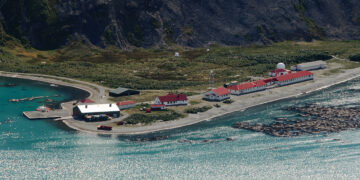
King Edward Point Research Station
Read more of: King Edward Point Research StationKing Edward Point Research Station on South Georgia has been a centre for marine and fisheries research for 25 years.
-
Bird Island Research Station
Read more of: Bird Island Research StationThe Bird Island Research Station focuses on the long-term study of seabirds and seals in one of the world’s richest wildlife sites.
-
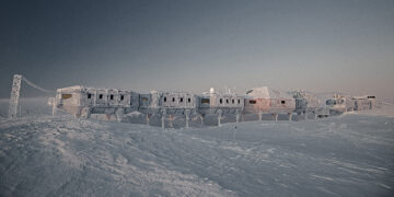
Halley VI Research Station
Read more of: Halley VI Research StationHalley Research Station is globally significant for observing the Earth, its atmosphere, and space weather.