Innovative Research Sprints Tackle Challenges in Biodiversity and Exposure
Over the last decade, digital technologies, including Artificial Intelligence, developed rapidly as did our capability to monitor our home planet from space with Earth Observation satellites. How can we most effectively gain insight from this data and harness the benefits for nature and humanity?
BAS AI lab teamed up with the Phi-Lab of the European Space Agency (ESA) and the UKRI Centre for Doctoral Training in the Application of Artificial Intelligence to the study of Environmental Risks (AI4ER) in the AI4EO Accelerator project. The project brings the many and varied possibilities of Artificial Intelligence (AI) to Earth Observations (EO). Within this framework innovative research sprints connect partners in industry, national and international organisations and the third sector with students to tackle real world problems. This enables rapid prototyping of solutions to urgent challenges. The first two research sprints ran from December 2020 to March 2021 on the topics of biodiversity and exposure.
Biodiversity
The group working on biodiversity partnered with the UN Environment Programme World Conservation Monitoring Centre (UNEP WCMC) and British Trust for Ornithology (BTO). They addressed the risk to biodiversity due to habitat fragmentation. Fragmentation occurs when parts of a habitat are lost due to for example change of land use, leaving behind smaller unconnected areas. This makes survival of the species of the habitat more challenging. The students developed a georeferenced graph-based framework. It can track individual habitats over time, test connectivity between different habitat areas by taking into account the distance a species can travel. It calculates standard metrics in addition to novel metrics. The practitioner can visualize different scenarios and gather relevant metrics to give informed advice to policy makers which conservation efforts have the greatest impact.
Exposure
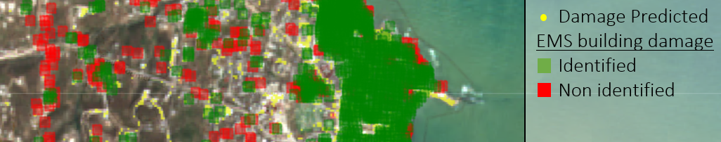
The other group partnered with Willis Tower Watson (WTW), Risk Management Solutions (RMS) and Descartes Labs. They investigated exposure as one of the corners of the risk triangle, the other parameters being hazard and the vulnerability. Exposure is defined as the degree to which elements-at-risk are exposed to a particular hazard, and therefore subject to potential losses. The students concentrated on informal settlements, since they are often unaccounted for by local governments, motivating a remote sensing approach. They investigated the suitability of Sentinel-2 satellite imagery at a resolution of 10 meters per pixel by applying five different methods. For each of the methods the success varied with the resolution. Change detection before and after a disaster informs where rescue and later rebuilding efforts need to be concentrated. Evaluating satellite imagery gives insight into whether the UN sustainability target of building resilience to natural disasters is met and reduce disaster risk are progressing.
Robert Muir-Wood of RMS comments “There is underway the beginnings of a major global mission, to repeat every few years the collection of comprehensive, vulnerability-linked building exposure data, in narrow time-windows, so we can use catastrophe loss models to measure whether progress is being made in disaster risk reduction. This will require employing remote-sensed imagery and automating the process of exposure data generation, using AI and machine learning. As the guided team challenge participants identified, there is a need for a particular focus on informal settlements, often located on land that is considered too steep, landslide-ridden, or flood prone, for official housing. This team challenge project saw some excellent, imaginative initiatives in exploring how AI applications could be employed with imagery and has taught us all an important lesson about the resolution of imagery required to identify the characteristics of individual buildings, as well as what elements to look out for in separating official from informal settlements. In taking this research forward we will build on this work, and focus on the highest resolution imagery data, including that specially flown, or made available, in the aftermath of disasters.”
The results will be presented as part of the Application of AI to the study of Environmental Risks (AI4ER) CDT Showcase which will take place online on 14 May 2021 from 12pm to 4pm. If you would like more information on the AI4ER please contact their partner liaison.
Biodiversity team: Herbie Bradley, Arduin Findeis, Katherine Green, Yilin Li, Simon Mathis, Simon Thomas
Exposure team: Matt Allen, Luke Cullen, Seb Hickman, Joycelyn Longdon, Ira Shokar, Leyu Yao.