Exposure
Assessing Temporal Change in the Exposure of Informal Settlements through Repeat Satellite Observation
Exposure is one of the corners of the risk triangle, the other parameters being hazard and the vulnerability. In this context exposure is defined as the degree to which elements-at-risk are exposed to a particular hazard, and are subject to potential losses.
The Importance
Robert Muir-Wood from Risk Management Solutions describes the importance of the project. “To discover what real progress has been made in achieving resilience against casualties and damage from earthquake, hurricane or flood perils, at present we have to wait for a disaster to happen. Yet the impacts are latent years before the disaster strikes. As the insurance industry has discovered, risk modelling can teach us how to simulate catastrophe losses and now we can apply these same tools to identify how progress is being made in disaster reduction. The key is to collect synoptic exposure data, on buildings, infrastructure, possessions and people for a narrow time window, and to measure the underlying risk in a catastrophe model. Through this risk auditing procedure, revisited perhaps every five years, we can identify how the level of disaster risk is changing. In many instances the models exist, and the challenge is collecting the detailed exposure data, including those factors most relevant to assessing vulnerability, using high resolution aerial imagery and AI/ML, as well as absorbing census data and street view perspectives. Risk auditing should be the future for measuring progress in disaster risk reduction, in particular in hazard afflicted regions like the islands of the northeast Caribbean.”
The Solution
Informal settlements are often unaccounted for by local governments, motivating a remote sensing approach. The project examined Sentinel-2 satellite imagery at a resolution of 10 meters per pixel. Three algorithms were tested to segment informal settlements. These were a Random Forest as well as two semi-supervised Deep Learning models. The scarcity of labelled data necessitates the use of semi-supervised techniques where far fewer labelled data are needed. To detect change before and after a disaster, the first approach was a ratio method, comparing the intensities of certain bands of pairs of satellite images. Supervised deep learning extended this. All algorithms struggled to a degree with the low resolution of Sentinel-2 imagery. To demonstrate the viability of the approaches the algorithms were also applied to high resolution imagery. To quantify exposure, the information extracted from imagery needs to be linked to existing datasets of elements-at-risk, such as the Global Human Settlement Layer (GHSL).
The Code
The code repository contains a demo Jupyter notebook as well as a binder link. This enables you to run a demonstration in a web browser without installing anything locally.
The Data
The data investigated were:
- Sentinel-2 imagery,
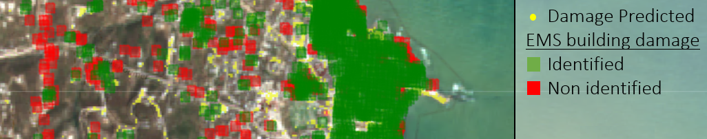
- Copernicus Emergency Management Service (EMS),
- Informal “colonias” in Hidalgo County, Texas from 1 x1 metre resolution National Agriculture Imagery Program images,
- xBD Dataset,
- Global Human Settlement Layer (GHSL),
- Global Assessment Report on Disaster Risk Reduction (GAR).
The Team
This project was undertaken by Matt Allen, Luke Cullen, Seb Hickman, Joycelyn Longdon, Ira Shokar, Leyu Yao.
The Partners
 |
 |
 |