Machine Learning Research Scientist
AI for smart conservation
AI for smart conservation
- Start date:
- 1 July, 2022
- End date:
- 30 October, 2024
What AI for smart conservation does
The project develops AI-based tools to support conservation planning in the rapidly changing Arctic. It combines sea ice forecasts, satellite data, GPS tracking, and local expert knowledge.
The goal is to provide early-warning systems for wildlife movement and distribution. These tools help conservation practitioners design adaptive management plans to protect vulnerable polar species.
Why this matters
Climate change is reshaping Arctic ecosystems. Species such as polar bears, walrus, and caribou depend on sea ice, which is becoming increasingly unpredictable and short-lived.
At the same time, shipping, fishing, mining, and tourism are expanding into the Arctic. Adaptive management is essential to protect wildlife under these changing conditions.
How the project works
AI for smart conservation builds on advances in sea ice forecasting:
- AI forecasting: IceNet, an operational model under development, predicts daily pan-Arctic sea ice concentration up to three months ahead at 25 km² resolution.
- Early-warning systems: forecasts are linked with GPS data on wildlife movement. This provides advance notice of when species are likely to migrate or change habitat.
- Decision support: outputs are shared with conservation agencies, enabling fast and informed planning.
Case study: dolphin and union caribou
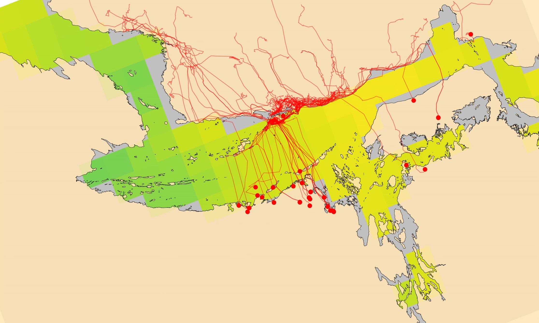
BAS works with the Government of Nunavut and WWF to develop an early-warning system for Dolphin and Union (DU) caribou. These caribou migrate across sea ice in the Coronation Gulf twice a year. Climate change is forcing them to migrate later and over weaker ice. Vessel traffic also disrupts crossings.
Figure 1 : GPS collared caribou migrating across sea ice in the Coronation Gulf during the autumn freeze up. Tracks overlaid on 25km OSI-SAF (left) and 6km AMSR2 data (right). We can see the caribou wait on the south coast of Victoria Island for the sea ice to reach safe levels for crossing. Using IceNet we can predict when the ice will form, and therefore give early-warning for when the caribou are likely to begin their migration.
By linking sea ice data with GPS tracks, the team identified the ice conditions caribou wait for before migrating. IceNet forecasts predict when these thresholds will be met. Software engineers are integrating outputs into an online platform for use by local agencies. The tool will give conservationists quick access to forecasts, real-time collar data, and risk maps.
Future work
The project is extending this approach to other Arctic species. Examples include:
- predicting polar bear arrivals near communities to reduce conflict
- anticipating walrus haul outs to prevent disturbance and stampede events
- forecasting cetacean migration routes to mitigate ship strikes and noise impacts
Science objectives
The project aims to:
- combine AI forecasting with ecological data to support conservation
- develop early-warning systems for wildlife movement
- provide decision-support tools for adaptive management
- protect vulnerable Arctic species under climate change
- explore applications across multiple species and regions
Who is involved
The project is led by BAS in collaboration with local ecologists and conservation agencies. Partners include the Government of Nunavut and WWF.
Science objectives
The project aims to:
- combine AI forecasting with ecological data to support conservation
- develop early-warning systems for wildlife movement
- provide decision-support tools for adaptive management
- protect vulnerable Arctic species under climate change
- explore applications across multiple species and regions
-

-

Ecosystem Scientist
-

Machine Learning Research Scientist
Artificial Intelligence (AI) Lab, BAS Science Strategy Executive Group