A research mission to determine the impact of the giant A-68a iceberg on one of the world’s most important ecosystems departs from Stanley in the Falkland Islands today (2 February 2021). A team of scientists, led by British Antarctic Survey (BAS), will set sail on the National Oceanography Centre’s (NOC) ship bound for the sub-Antarctic island of South Georgia.
The huge berg broke away from Antarctica’s Larsen C Ice Shelf in 2017. After satellite images revealed its movement towards South Georgia, the science team put a proposal to NERC to fund an urgent mission south. Images captured from the air by the MOD in late 2020 show that the iceberg is breaking up. It now consists of several icebergs named A68a-m. The team will investigate the impact of freshwater from the melting ice into a region of the ocean that sustains colonies of penguins, seals and whales. These waters are also home to some of the most sustainably managed fisheries in the world.
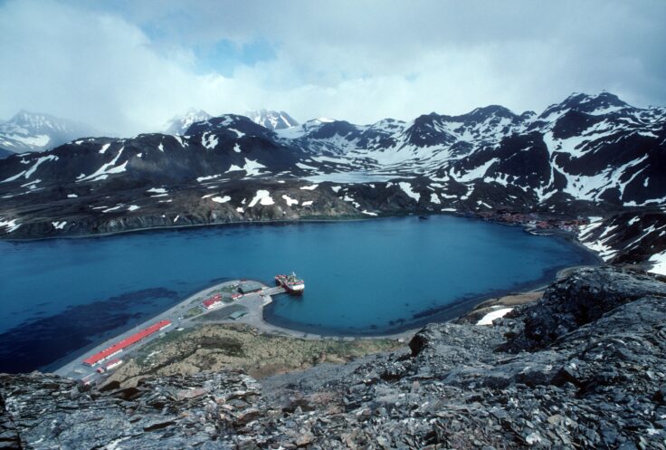
King Edward Point Research Station on the island of South Georgia
Underwater robotic gliders will be deployed from the NOC research ship RRS James Cook, which will arrive at the icebergs in mid February.
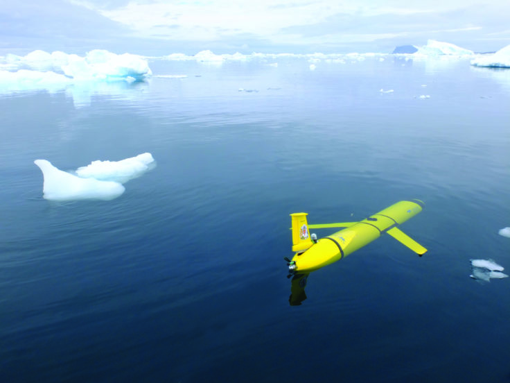
Scientists will deploy two Slocum gliders to collect data from the A68a iceberg. Photo credit_David White
Lord Goldsmith, Minister for Pacific and the Environment, says:
“We need to understand the effects that huge icebergs can have on wildlife and marine life, so I’m delighted the Blue Belt Programme, which works with British Overseas Territories to protect and sustainably manage their waters, is able to support this critically important research mission.”
Oceanographer Dr Povl Abrahamsen, from British Antarctic Survey, is leading the mission. He says:
“We have a unique opportunity to visit the icebergs. Normally, it takes years to plan the logistics for marine research cruises, but NERC, working with the Government of South Georgia and the South Sandwich Islands and the UK Government’s Blue Belt Programme, recognised the urgency to act quickly, allowing us to study the icebergs during an upcoming voyage to monitor the ecosystem and climate of the Southern Ocean. Everyone is pulling out all the stops to make this happen.”
The two 1.5-metre long untethered submersible gliders will spend almost four months collecting measurements of seawater salinity, temperature, and chlorophyll from opposite sides of the largest sections of iceberg, piloted over satellite link by personnel at NOC and BAS. The team will also measure how much plankton is in the water and compare their findings with long-term oceanographic and wildlife studies around South Georgia and nearby Bird Island.
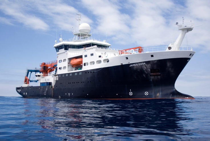
The mission is taking place on the National Oceanography Centre’s ship RRS James Cook. Photo credit: NOC
Waters around South Georgia are recognised as one of the most biologically rich places on the planet with more described marine species than the Galapagos, and is one of the world’s largest Marine Protected Areas. The icebergs, if they grounds near the island, pose a risk to penguins and seals during the breeding season.
Professor Geraint Tarling, an ecologist at British Antarctic Survey, says:
“The icebergs are going to cause devastation to the sea floor by scouring the seabed communities of sponges, brittle stars, worms and sea-urchins, so decreasing biodiversity. These communities help store large amounts of carbon in their body tissue and surrounding sediment. Destruction by the icebergs will release this stored carbon back into the water and, potentially, the atmosphere, which would be a further negative impact.”
“However, whilst we are interested in the effects of A-68a’s new arrival at South Georgia, not all the impacts along its path are negative. For example, when travelling through the open ocean, icebergs shed enormous quantities of mineral dust that will fertilise the ocean plankton around them, and this will benefit them and cascade up the food chain.”
Steve Woodward, the NOC’s Glider Technical Lead, who will be managing the National Marine Equipment Pool (NMEP) glider operation, says:
“Autonomous submarine gliders are an excellent, cost-effective, and sustainable means of gathering and recording important marine data. In this case, we will program the NMEP gliders to get as close to the edge of the icebergs as we feel is safe and practicable, and collect the data that will be needed to enable the team to understand the implications of what is taking place with A-68a.”
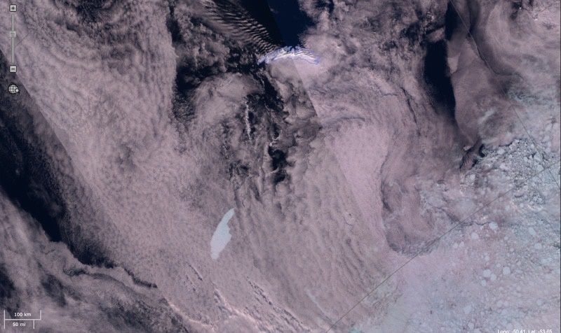
Mapping A68a, 2 February 2021 – Update of our A68a iceberg tracking map, showing the locations of a, d, e & the newly formed A68g, officially named by US National Ice Center. Map produced by the Mapping and Geographic Information Centre, BAS, using Copernicus Sentinel-1 satellite imagery to monitor the iceberg locations. Credit: Laura Gerrish BAS Mapping team
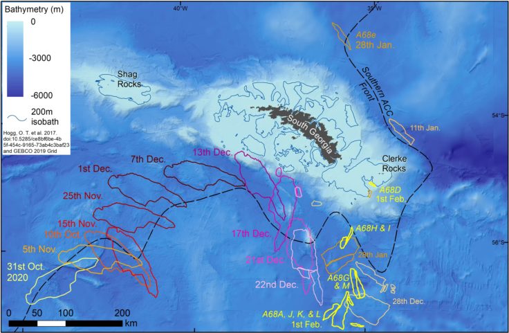
Andrew Fleming, Head of Remote Sensing at BAS, has been tracking the iceberg’s journey on images from the Copernicus Sentinel-1 and other satellites. He says:
“We are watching the progress of the A-68a iceberg very closely as we haven’t seen a berg of this size in the area for some time. As it breaks up, thousands of smaller icebergs have the possibility to obstruct shipping lanes in the area, especially as they disperse. The European Space Agency has delivered regular Sentinel-1 images and we will use these to continue tracking in the coming months.
“The images and footage collected by MOD flight missions have helped enormously in confirming some of the features we can see in the images from space. Close up images provide detail on how the berg is starting to break up and allow us to better understand these processes.”
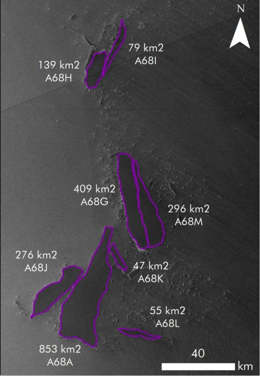
The A68a iceberg has splintered into several pieces. Copernicus Sentinel-1 image acquired on 01-02-2021 21:41:25 UTC, processed by ESA. The largest section remains over 853 square kms in size.
Dr Mark Belchier, Director of Fisheries and Environment at Government of South Georgia and the South Sandwich Islands (SGSSI), says:
“With such events predicted to increase in frequency, understanding their impacts on SGSSI’s ecosystem is essential for informing the Government’s sustainable stewardship of the territory”.
The research expedition to A-68a has been funded by a combination of the Natural Environment Research Council, the Government of South Georgia and the South Sandwich Islands, and the UK Government’s Blue Belt Programme.
More information
Underwater gliders are small submersible robotic vehicles, which are designed to operate autonomously for months at a time. Rather than using a propeller, they move by changing their buoyancy, and wings convert this into forward motion. While “flying” through the water, sensors can measure temperature, salinity, chlorophyll, and other parameters. At regular intervals, the gliders will surface, check their position by GPS, transmit data back to servers in the UK, and check for new instructions on where to go.
The A-68 iceberg broke off the Larsen C Ice Shelf in 2017; the largest remaining section is now denoted A-68a. The calving is thoughts by scientists to be a natural event and not directly attributed to climate change. However, models predict that a warmer Antarctica in the future will have more calving events as ice shelves and glaciers retreat.
British Antarctic Survey (BAS), an institute of the Natural Environment Research Council (NERC) and part of UKRI, delivers and enables world-leading interdisciplinary research in the Polar Regions. Its skilled science and support staff based in Cambridge, Antarctica and the Arctic, work together to deliver research that uses the Polar Regions to advance our understanding of Earth as a sustainable planet. Through its extensive logistic capability and know how BAS facilitates access for the British and international science community to the UK polar research operation. Numerous national and international collaborations, combined with an excellent infrastructure help sustain a world leading position for the UK in Antarctic affairs.
For more information visit our website www.bas.ac.uk or social media; TW @BAS_news, FB @BritishAntarcticSurvey, LI @british-antarctic-survey, IG @britishantarcticsurvey
The National Oceanography Centre (NOC) is the UK’s leading institution for integrated coastal and deep ocean research. NOC undertakes and facilitates world-class agenda-setting scientific research and technology development to understand the global ocean by solving challenging multidisciplinary, large scale, long-term marine science problems to underpin international and UK public policy, business and societal outcomes. The NOC is a company limited by guarantee set up under the law of England and Wales (11444362) and registered as a charity (1185265).
The NOC operates the Royal Research Ships James Cook and Discovery and develops technology for coastal and deep ocean research. Working with its partners the NOC provides long-term marine science capability including: sustained ocean observations, mapping and surveying; data management and scientific research and advice.
Among the resources that the NOC provides on behalf of the UK are the British Oceanographic Data Centre (BODC), the Marine Autonomous and Robotic Systems (MARS) facility, the National Marine Equipment Pool (NMEP), the National Tide and Sea Level Facility (NTSLF), the Permanent Service for Mean Sea Level (PSMSL) and British Ocean Sediment Core Research Facility (BOSCORF).
The Blue Belt Programme supports the UK Overseas Territories with the protection and sustainable management of their marine environments. Since 2016 the Blue Belt Programme has helped the Overseas Territories enhance marine protection across 4.3 million square kilometres of marine environment.
This flagship programme has been central to the UK government’s ambition of leading action to tackle the serious global problems of overfishing, species extinction and climate change. It is supported by two world leading organisations – the Centre for Environment, Fisheries and Aquaculture Science (Cefas) and the Marine Management Organisation (MMO) on behalf of the UK government. For more information visit our website, Twitter, Facebook and blog.