NEWS STORY: Mountains frozen in time
Antarctic “ghost mountains” preserved by ice sheet
A new study reveals how the rugged ridgelines of East Antarctica’s ancient and mysterious ‘ghost mountains’ have been preserved for millions of years by the massive ice sheet that envelopes them. Reporting this week in the journal Geophysical Research Letters, an international team of scientists describe how they were surprised to discover that the Gamburtsev Subglacial Mountains show little sign of erosion, and that its saw-toothed towering crags resemble the modern ranges like the European Alps or Rocky Mountains.
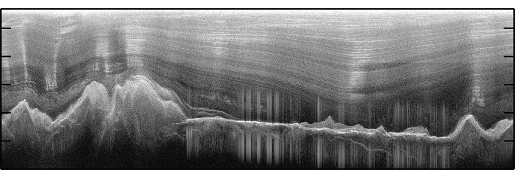
Images of the ice-covered Gamburtsev Mountains revealed water-filled valleys, as seen by the cluster of vertical lines in this image (Tim Creyts, University of Columbia)The results, from a seven-nation airborne geophysical campaign to map what lies beneath the ice, are an important step in understanding ice sheet growth and long-term stability in the interior of East Antarctica.
The enigmatic Gamburtsev Subglacial Mountains, which lie buried beneath as much as 3 km (two and a half miles) of ice, are the focus of intense study.
Dr Fausto Ferraccioli, Head of Airborne Geophysics at British Antarctic Survey is a co-author on the paper. He said:
“How mountain ranges form and are preserved in the middle of old continents for millions of years are fundamental questions in Earth Sciences. Our new research has important additional ramifications for our understanding of long-term climate and ice sheet change. This study shows that interplays between topography, water, ice sheets and tectonics must be considered in order to understand the preservation of mountain ranges such as the Gamburtsev Subglacial Mountains. If these mountains in interior East Antarctica had been more significantly eroded, then the ice sheet itself may have had a different history.”
Scientists hypothesize that cold temperatures and high pressures push the water uphill, in the same direction as overlying ice flows. This causes ridgelines to refreeze, thus warding off erosion (Tim Creyts, University of Columbia)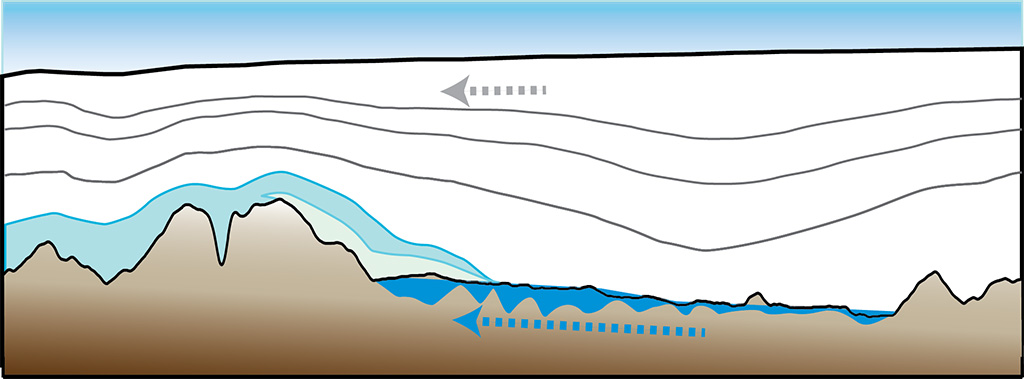
The Gamburtsev Subglacial Mountains were first discovered in 1958, but remained unexplored until scientists flew ice-penetrating instruments over the mountains 50 years later. As this ancient hidden landscape was revealed, scientists were stunned to see the saw-toothed and towering crags typical of much younger mountains. More surprising still, the scientists discovered a network of lakes and rivers in the valleys that cut through the Gamburtsevs.
Though water usually speeds erosion, here water largely re-freezes on to the rugged ridgelines protecting them from widespread erosion. This process may have been active over the last 34 million years, when the Antarctic ice sheet first formed.
“The ice sheet acts like an anti-aging cream,” said the study’s lead author, Timothy Creyts, a geophysicist at Columbia University’s Lamont-Doherty Earth Observatory. “It triggers a series of thermodynamic processes that have almost perfectly preserved the Gamburtsevs since ice began spreading across the continent.”
Snow falling at the surface of the ice sheet draws colder temperatures down, closer to the peaks of the Gamburtsevs in a process called divergent cooling. At the same time, heat radiating from bedrock beneath the ice sheet helps melt ice in the deep valleys to form rivers and lakes. As rivers course along the base of the ice sheet, high pressures from the overlying ice sheet push water up valleys in reverse. This uphill flow refreezes as it meets colder temperature from above. Thus, ridgelines are cryogenically preserved.
A seven-nation team of scientists explored the Gamburtsev Subglacial Mountains during the International Polar Year (2007–09) by using two twin-engine aircraft equipped with ice penetrating radars, gravity meters and magnetometers.
Other authors: Fausto Ferraccioli, Hugh Corr and Tom Jordan of British Antarctic Survey; Robin Bell, Michael Wolovick and Nicholas Frearson of Lamont-Doherty; Kathryn Rose of University of Bristol; Detlef Damaske of Germany’s Federal Institute for Geosciences and Natural Resources; David Braaten of Kansas University; and Carol Finn of the U.S. Geological Survey.