Auroral Boundary Location Method
To estimate the poleward and equatorward boundaries of auroral emissions, we perform the following steps:
Step 1 – Get an IMAGE FUV image
The website maintained by the IMAGE FUV team outlines how to obtain IMAGE FUV data. IMAGE data is provided in the NASA universal data format (UDF). The FUVIEW3 software provided by the IMAGE FUV team was used to process the IMAGE FUV data. FUVIEW3 is written for the IDL language and makes use of UDF software to convert the auroral image data into IDL format. The data structure returned by the FUVIEW3 software contains a number of data fields, including the original auroral image, and the magnetic latitude, longitude, and local time of each pixel in that image in the APEX coordinate system.
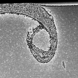
Sample WIC Image 2000 Dec 01 00:22 UT – Sample WIC image from 1st Dec 2000 at 00:22 UT
Step 2 – Convert magnetic coordinates of image
Each IMAGE FUV auroral image was converted into the AACGM coorindate system (Baker and Wing, 1989). A sample animation showing a sequence of auroral images in AACGM coordinates taken by the WIC instrument between 00 and 06 UT on 1st February 2001 can be found here.
Step 3 – Create latitudinal intensity profiles
Each image was divided into 24 segments covering 1 hour of magnetic local time (MLT). For each MLT segment, an intensity profile was constructed by finding the average intensity across bins of 1o magnetic latitude in the range of 50o to 90o AACGM.
Step 4 – Fit functions to the intensity profiles
Two functions were fit to each intensity profile; a function with one Gaussian component and a quadratic background, and a function with two Gaussian components and a quadratic background. The function with a single Gaussian component should provide a reasonable model when the auroral emission forms in a continuous oval. When the oval shows bifurcation, the function with two Gaussian components may provide a better model of the auroral emission. An example profile with a single Gaussian fit (blue curve) and a double Gaussian fit (red curve) can be found here. These fits provide estimates of the amplitude, centre, and width of the one or two main peaks in the intensity profile.
Step 5 – Determine the better model
Of the two functions fit to each intensity profile, we determine the one with the lower reduced chi-square goodness-of-fit statistic to be the better model for that profile
Step 6 – Estimate the auroral boundaries
When the fit of the single Gaussian function provides the better model of an intensity profile, the auroral boundaries are estimated using the full width at half maximum (FWHM) of the Gaussian peak, with the poleward boundary being the location of the centre of the peak plus the FWHM and the equatorward boundary being the location of the centre of the peak minus the FWHM. When the double Gaussian function provides the better fit, the FWHMs and offsets from the location of the Gaussian centres were calculated for both peaks and the most equatorward and poleward offsets were used as the auroral boundaries. The equatorward and poleward boundary estimates made from the single and double Gaussian fits are marked by the vertical dashed line in the example profile.
Step 7 – Discard “bad” boundaries
A number of criteria were applied to discard poorly located auroral boundaries arising from either poor fitting or incomplete data. The criteria applied are as follows:
- The amplitude(s) of the fitted Gaussian(s) must be greater than zero
- The location of the centre(s) of the fitted Gaussian(s) must fall within the latitude range of the intensity profile
- The amplitude(s) of the fitted Gaussian(s) must exceed the amplitude of the background by at least 10% of the background intensity
- For fits of double Gaussian function, the amplitude of the secondary peak must be at least 20% of the amplitude of the main peak
- The width(s) of the fitted Gaussian(s) must exceed 1o (the latitude bin width) but not exceed the total range of the intensity profile
- The reduced chi-square goodness-of-fit statistic must not exceed 10
- The uncertainty of the auroral boundaries must not exceed 1o for boundaries derived from WIC images or 2o for SI12 and SI13 images (due to the lower resolution of these images)
Step 8 – Apply boundary corrections to estimate Open-Closed magnetic field line Boundary (OCB) – OPTIONAL
The poleward boundaries of the auroral oval calculated following Steps 1 to 7 can be used to estimate the location of the OCB. To do this, we have calibrated these boundaries with the relevant particle precipitation boundaries derived from DMSP satellite data. This calibration has produced a set of offset values for each MLT bin and each FUV camera. These offsets should be added to poleward auroral boundary latitude to estimate the OCB latitude. More information about this calibration and our suggested offset values can be found in here. We recommend that this step be followed and these boundary corrections be applied when using these boundaries as a proxy for the OCB.
References