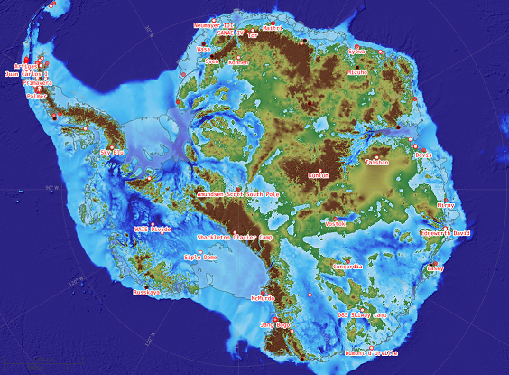
A newly updated Antarctic Digital Database is released today (12 May 2020). Aimed at the science and logistics communities, the maps include updates to the ice shelf front around Thwaites Glacier in West Antarctica, a new coastline for the South Shetland Islands and updated contours on the South Orkney Islands.
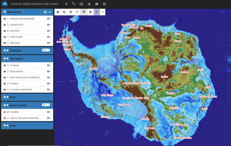
The updated Antarctica Digital Database Map Viewer (www.add.scar.org)
The Antarctic Digital Database (ADD) is a compilation of the best available topographic datasets for Antarctica, managed by BAS Mapping and Geographic Information Centre (MAGIC) on behalf of The Scientific Committee on Antarctic Research (SCAR). The compilation has been running for over 25 years and has tracked important changes in Antarctica, such as the break-up of large ice shelves and the revelation of new islands as the ice has retreated. The datasets represent an international team effort, combining contributions from numerous national Antarctic mapping agencies.
The ADD is updated every six months and in each update MAGIC assesses if there have been any significant changes to the coastline and ice shelves, as well as assessing which new or updated datasets need merging into the compilation. The ADD is a product of SCAR group Standing Committee on Antarctic Geographic Information (SCAGI).
This release (version 7.2) involves updates to the ice shelf front around Thwaites Glacier, a current area of great scientific interest as it is contributing to global sea-level rise; a new coastline for the South Shetland Islands taken from BAS’s new map published last year; and updates to the contours on the South Orkney Islands, a notoriously difficult place to map due to their remote location in the Southern Ocean and the cloudy weather that often obscures them from satellites.

Updated mapping of the ice shelf front around Thwaites Glacier, including newly discovered ‘Sif Island’ from the 2019/20 International Thwaites Glacier Collaboration (ITGC) field season.
In addition, brand new datasets have been added to the Map Viewer. These include the Antarctic BedMachine dataset published this year, which shows the bed topography of Antarctic at a never before seen level of detail. The Reference Elevation Model of Antarctica (REMA) dataset is also shown in the viewer; this was published in 2018 by Polar Geospatial Center in America and allows users to view the large mountain ranges in Antarctica.
Laura Gerrish, GIS and Mapping Specialist with BAS MAGIC team, says
“It has been really exciting to work on the latest update for the Antarctic Digital Database. The ADD has been running since the early 1990s and it is a great project to be a part of. I enjoy thinking of new ways to present and visualise the data and my favourite part of the work is looking through fascinating satellite images and identifying features that might never have been seen before. The new release is a step-change in the way that the data is presented, making it easier than ever for people to access and work with the data.”
Version 7.2 represents a complete change to the management of the data catalogue. Full metadata can now be easily accessed for each data layer, and the data can be accessed in a variety of formats.
Antarctic Digital Database (ADD) Data Catalogue: https://data.bas.ac.uk/collections/e74543c0-4c4e-4b41-aa33-5bb2f67df389/
ADD BAS Project Page: https://www.bas.ac.uk/project/add/
ADD Homepage: https://www.scar.org/data-products/antarctic-digital-database/
ADD Viewer: https://www.add.scar.org/