Scientists have completed the first phase of a research mission to determine the impact of the giant A-68a iceberg on one of the world’s most important ecosystems.
A team of researchers and engineers, from British Antarctic Survey (BAS) and National Oceanography Centre (NOC), have deployed two robotic gliders. The team is on the research ship RRS James Cook, operated by NOC, currently 200 km offshore the sub-Antarctic island of South Georgia.

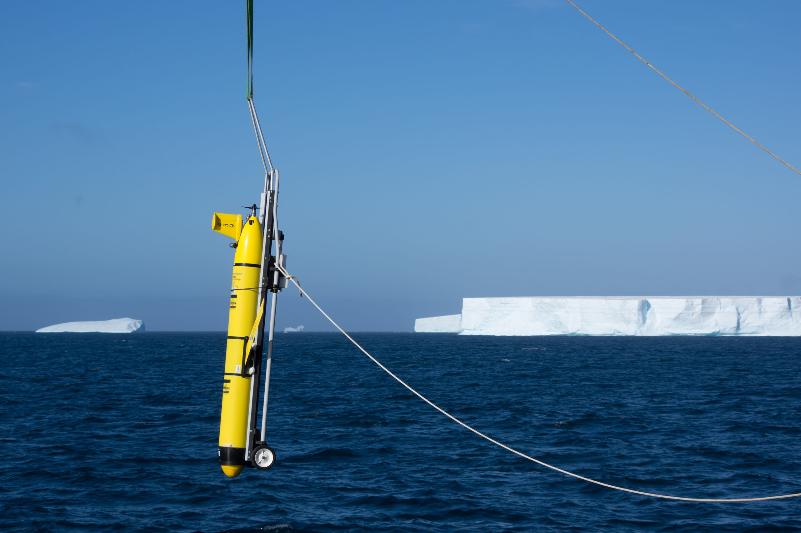
Two gliders were deployed near the A-68a iceberg near South Georgia. Photo credit_Povl Abrahamsen
The A-68a broke away as a huge iceberg from Antarctica’s Larsen C Ice Shelf in 2017. Over the last few months it has been close to South Georgia, where it shattered into countless smaller icebergs, 12 of which are still large enough to be officially named and tracked. The largest remaining piece is 50 km long and almost 900 square km in area, similar in size to the Isle of Mull in Scotland.
Oceanographer Dr Povl Abrahamsen, from British Antarctic Survey, is the science leader of the mission. He says:
“After months of planning it’s tremendously exciting to be here. We have made measurements around the largest remaining iceberg, A-68a, and deployed one robotic underwater glider near this iceberg. A second was deployed near the most newly named fragment, A-68p, and will be making its way toward A-68a from the north. Both gliders will continue measuring around the iceberg even after we need to leave. It’s been a very scenic area to work in, with vast tabular icebergs that stretch as far as you can see, and so many smaller icebergs and bits of ice that have broken off of them.”
The two 1.5-metre long robotic submersible gliders will spend almost four months collecting measurements of seawater salinity, temperature, and chlorophyll, piloted over satellite link by personnel at NOC and BAS. The team has measured how much and what types of plankton are in the water, and will compare their findings with long-term oceanographic and wildlife studies around South Georgia and nearby Bird Island.
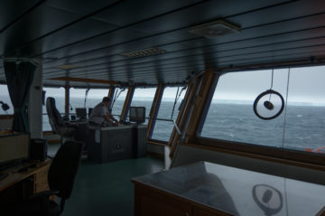
The science and engineering team are on the RRS James Cook operated by NOC. Photo credit_Povl Abrahamsen
Data collected will help the team understand the impact of extremely cold freshwater from the melting ice into a region of the ocean that sustains colonies of penguins, seals and whales. These waters are also home to some of the most sustainably managed fisheries in the world.
Maaten Furlong, Head of the Marine Autonomous & Robotics Systems Group at the NOC, says:
“We have developed a world leading web application to pilot and manage the data from long range ocean robots. It uses satellite data to assist in piloting the gliders which can be deployed from anywhere in the world.
“Having an advanced piloting tool makes these bespoke operations a lot easier. For this campaign we adapted the software to show the A-68a position from satellite data. This allows us to get the glider close to the ice and to take the necessary measurements. These measurements will allow the science team to better understand the impact of the A-68a on the local environment and marine life.”
Waters around South Georgia are recognised as one of the most biologically rich places on the planet with more described marine species than the Galapagos, and is one of the world’s largest Marine Protected Areas. If the icebergs run aground near the island, they may pose a risk to penguins and seals during the breeding season.
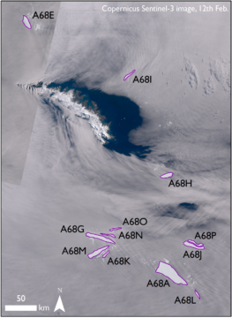
Graphic shows the latest position of the icebergs around sub-Antarctic South Georgia. Credit_Copernicus Sentinel-3
Dr Martin Collins, Science Manager for South Georgia at British Antarctic Survey, says:
“We have watched with great interest as this giant iceberg has calved into smaller pieces around South Georgia. We will be looking at the impact of enormous quantities of mineral dust coming off the icebergs that will fertilise the ocean plankton around them, and cascade up the food chain.”
The research expedition to A-68a has been funded by the Natural Environment Research Council, the Government of South Georgia and the South Sandwich Islands, and the UK Government’s Blue Belt Programme.
More information
Underwater gliders are small submersible robotic vehicles, which are designed to operate autonomously for months at a time. Rather than using a propeller, they move by changing their buoyancy, and wings convert this into forward motion. While “flying” through the water, sensors can measure temperature, salinity, chlorophyll, and other parameters. At regular intervals, the gliders will surface, check their position by GPS, transmit data back to servers in the UK, and check for new instructions on where to go.
The A-68 iceberg broke off the Larsen C Ice Shelf in 2017; the largest remaining section is now denoted A-68a. The calving is thoughts by scientists to be a natural event and not directly attributed to climate change. However, models predict that a warmer Antarctica in the future will have more calving events as ice shelves and glaciers retreat.
The National Oceanography Centre (NOC) is the UK’s leading institution for integrated coastal and deep ocean research. NOC undertakes and facilitates world-class agenda-setting scientific research and technology development to understand the global ocean by solving challenging multidisciplinary, large scale, long-term marine science problems to underpin international and UK public policy, business and societal outcomes. The NOC is a company limited by guarantee set up under the law of England and Wales (11444362) and registered as a charity (1185265).
The NOC operates the Royal Research Ships James Cook and Discovery and develops technology for coastal and deep ocean research. Working with its partners the NOC provides long-term marine science capability including: sustained ocean observations, mapping and surveying; data management and scientific research and advice.
Among the resources that the NOC provides on behalf of the UK are the British Oceanographic Data Centre (BODC), the Marine Autonomous and Robotic Systems (MARS) facility, the National Marine Equipment Pool (NMEP), the National Tide and Sea Level Facility (NTSLF), the Permanent Service for Mean Sea Level (PSMSL) and British Ocean Sediment Core Research Facility (BOSCORF).
The Blue Belt Programme supports the UK Overseas Territories with the protection and sustainable management of their marine environments. Since 2016 the Blue Belt Programme has helped the Overseas Territories enhance marine protection across 4.3 million square kilometres of marine environment.
This flagship programme has been central to the UK government’s ambition of leading action to tackle the serious global problems of overfishing, species extinction and climate change. It is supported by two world leading organisations – the Centre for Environment, Fisheries and Aquaculture Science (Cefas) and the Marine Management Organisation (MMO) on behalf of the UK government. For more information visit our website, Twitter, Facebook and blog.