New research sheds light on Antarctica”s melting Pine Island Glacier
New results from an investigation into Antarctica’s potential contribution to sea level rise are reported this week (Sunday 20 June) by scientists from the British Antarctic Survey (BAS), Lamont-Doherty Earth Observatory (LDEO) and the National Oceanography Centre in the journal Nature Geoscience.

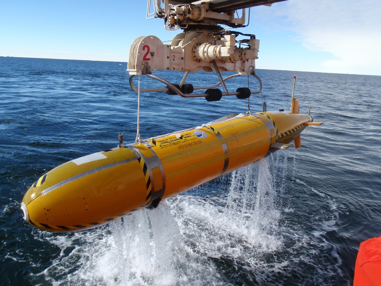
AUTOSUB 3 autonomous underwater vehicle being retrieved after observational missions beneath the floating tongue of Pine Island Glacier.
Thinning ice in West Antarctica is currently contributing a substantial and increasing volume to global sea level rise, and scientists have identified Pine Island Glacier (PIG) as a major source. As part of a series of investigations to better understand the impact of melting ice on sea level, an exciting new discovery has been made in the Amundsen Sea. Using Autosub (an autonomous underwater vehicle) to dive deep and travel far beneath the PIG’s floating ice shelf, scientists working on the research vessel NB Palmer made ocean and sea-floor measurements revealing a submarine ridge rising 300m above the sea floor.
Pine Island Glacier was once scraping across this underwater ridge, which slowed its flow. However, in recent decades it has thinned and disconnected from the ridge, allowing the glacier to move ice more rapidly from the land into the sea. This also permitted relatively warm seawater to flow over the ridge and into a widening inner cavity, more than doubling the ice shelf area exposed to the corrosive ocean. As the melting increases the glacier accelerates, drawing down the inland ice and moving its vulnerable grounding line (where the ice begins to float) deeper into the interior of the West Antarctic Ice Sheet.
Lead author Dr Adrian Jenkins of British Antarctic Survey said,
“The discovery of the ridge has raised new questions about whether the current loss of ice from Pine Island Glacier is caused by recent climate change or is a continuation of a longer-term process that began when the glacier disconnected from the ridge.
“We do not know what kick-started the initial retreat from the ridge, but we do know that it started some time prior to 1970. Since detailed observations of Pine Island Glacier only began in the 1990s, we now need to use other techniques such as ice core analysis and computer modelling to look much further into the glacier’s history in order to understand if what we see now is part of a long term trend of ice sheet contraction. This work is vital for evaluating the risk of potential wide-spread collapse of West Antarctic glaciers.”
Co-author Stan Jacobs adds:
“Since our first measurements in the Amundsen Sea, estimates of Antarctica’s recent contributions to sea level rise have changed from near-zero to significant and increasing. Now finding that the PIG’s grounding line has recently retreated more than 30 km from a shallow ridge into deeper water, where it is pursued by a warming ocean, only adds to our concern that this region is indeed the ‘weak underbelly’ (T. Hughes, 1981) of the West Antarctic Ice Sheet. Increased melting of continental ice also appears to be the primary cause of persistent ocean freshening and other impacts, both locally and downstream in the Ross Sea.”
ENDS
Research funded by the U.S. National Science Foundation (NSF) and UK Natural Environment Research Council (NERC)
Issued by the BAS Press Office:
- Heather Martin, Tel: +44 (0)1223 221414; mobile: 07740 822229; email: hert@bas.ac.uk
- Audrey Stevens, Tel: +44 (0)1223 221230; email: auev@bas.ac.uk
NOC Press Office:
- Rory Howlett, Tel: +44 (0)2380 598490; email: r.howlett@noc.soton.ac.uk
Scientist contact details:
- Dr Adrian Jenkins, British Antarctic Survey; Email: ajen@bas.ac.uk
- Dr Pierre Dutrieux, British Antarctic Survey; Tel: +44 (0)1223 221396; Mobile: 07736 921693; email: pitr1@bas.ac.uk
- Stan Jacobs, Lamont-Doherty Earth Observatory; Tel: 011 845 365 8326; Mobile: 011 845-521-0014; email: sjacobs@ldeo.colombia.edu
Notes for editors:
Stunning broadcast-quality footage and stills of Antarctica, along with a copy of the full Nature Geoscience paper are available at: ftp://ftp.nerc-bas.ac.uk/pub/photo/PIG/
Images used should be credited to British Antarctic Survey
Observations beneath Pine Island Glacier West Antarctica and implications for its retreat is published in Nature Geoscience.
Ice shelf
a thick, floating platform of ice that forms where a glacier or ice sheet flows down to a coastline and onto the ocean surface
Glacier
a mass of ice that moves over land
Ice core
cylinders of ice obtained by drilling into a glacier, which tell a story about past climate
Autosub is an AUV (Automated Underwater Vehicle), designed, developed and built at the National Oceanography Centre in Southampton with funding from the Natural Environment Research Council. Autosub3 has a maximum range of 400km and is powered by 5,000 ordinary D-cell batteries. The batteries are packed in bundles in pressure-tested housings. Either end of the seven-metre sub there are free-flooding areas where the payload of instruments are installed. It carries a multibeam sonar system that builds up a 3D map of the ice above and the seabed below. It also carries precision instruments for measuring the salinity, temperature, and oxygen concentrations in the sea water within the ice cavity, which are vital to understanding the flow of water within the ice cavity and the rate of melting. Autosub is 7m long and weighs 3.5 tonnes. Travelling at 6km hour it is capable of diving up to 1600m deep, and can operate for 72 hours (400 km) between battery changes.
Scientists worked aboard the US research vessel Nathaniel B Palmer.
British Antarctic Survey (BAS), a component of the Natural Environment Research Council, delivers world-leading interdisciplinary research in the Polar Regions. Its skilled science and support staff based in Cambridge, Antarctica and the Arctic, work together to deliver research that underpins a productive economy and contributes to a sustainable world. Its numerous national and international collaborations, leadership role in Antarctic affairs and excellent infrastructure help ensure that the UK maintains a world leading position. BAS has over 450 staff and operates five research stations, two Royal Research Ships and five aircraft in and around Antarctica.
Lamont-Doherty Earth Observatory (LDEO), a member of Columbia University’s Earth Institute, is one of the world’s leading research centres seeking fundamental knowledge about the origin, evolution and future of the natural world. More than 300 research scientists study the planet from its deepest interior to the outer reaches of its atmosphere, on every continent and in every ocean. From global climate change to earthquakes, volcanoes, non-renewable resources, environmental hazards and beyond, Observatory scientists provide a rational basis for the difficult choices facing humankind in the planet‘s stewardship. www.ldeo.columbia.edu
The National Oceanography Centre (NOC) is a new, national research organisation that went live on 1 April 2010. NOC will work in partnership with the UK marine research community to deliver integrated marine science and technology from the coast to the deep ocean.
NOC brings together into a single institution NERC-managed activity at the National Oceanography Centre, Southampton, and the Proudman Oceanographic Laboratory in Liverpool. NOC will work in close partnership with the wider marine science community to create the integrated research capability needed to tackle the big environmental issues facing the world. Research priorities will include the oceans‘ role in climate change, sea-level change and the future of the Arctic Ocean.
The NERC royal research ships RRS James Cook and RRS Discovery are based at NOC in Southampton, as is the National Marine Equipment Pool, which includes Autosub and Isis, two of the world’s deepest-diving research vehicles.