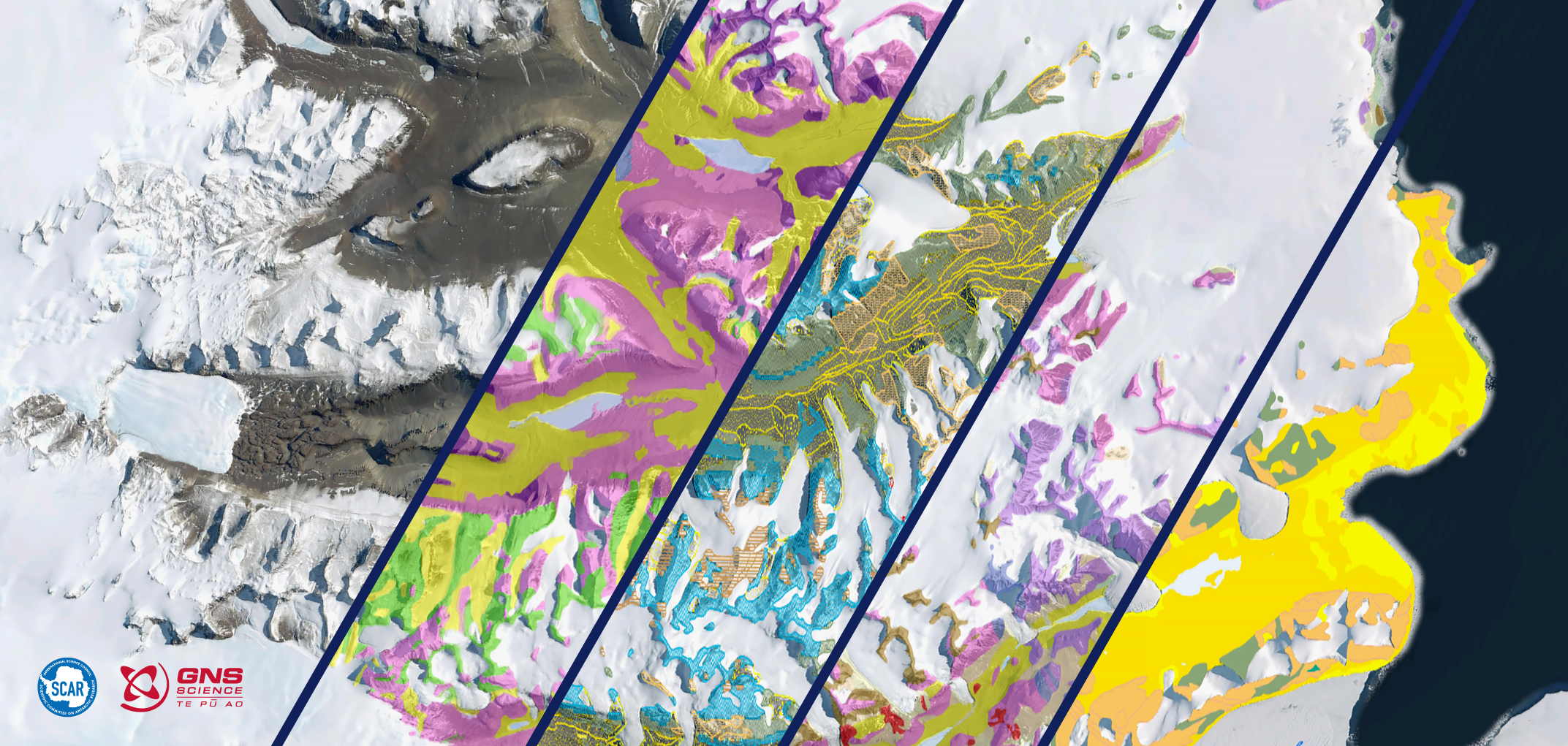
GeoMAP Antarctica, an open-access and comprehensive geological mapping database of Antarctica, was released today in Nature Scientific Data. Understanding Antarctica’s geosphere is, and has been, critical for understanding the continent’s major role in global climate – and thus, our future.
Constructing GeoMAP was a large, and long-term, international effort from Scientific Committee on Antarctic Research (SCAR), led by GNS Science in New Zealand. The project involved principal collaborators from USA, Norway, Italy, UK, Australia, Russia and New Zealand – including British Antarctic Survey Field Geologist, Dr Alex Burton-Johnson.
Despite Antarctica’s reputation as an icy expanse, over 52,000 km2 of exposed rock and sediment make up the mountains and surfaces of the continent. Each of these areas contain important information on the continent’s geological, geomorphological, and glaciological history. Put simply, rocks play an important role in – and tell us a lot about – the complex interaction of land, atmosphere, and climate. Geological knowledge of the continent’s mountains, sediments and soils, helps pinpoint the location, history and movement of glaciers, and even meltwater production. These insights provide foundational knowledge for researchers, from climate scientists, to biologists, to ecologists and volcanologists.
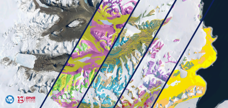
GeoMAP is rich with historical knowledge. Data layers across the continent show different facets of information, from rock type, rock age, meltwater patterns and links to where the original information came from.
Today, GeoMAP is the first detailed, digital, open-access database that collates all the historical, and existing, geological data of Antarctica. Geological study has taken place in Antarctica for over a century, so constructing GeoMAP to compile the existing geological knowledge into one place, took several years. The research effort included interpreting information from beautiful 20th Century hand-drawn maps, digitising hard-copy regional maps, and then integrating them with modern high-resolution datasets.
Lead data architect, Belinda Smith Lyttle from GNS Science says:
“There are still many areas in Antarctica yet to be visited by any geologist, and other areas where very detailed mapping has yet to be captured – and there is always new research taking place – so the GeoMAP database has been designed to be editable and improved over time.”
This effort was made possible by the co-funding from GNS Science’s Nationally Significant Databases and Collections Programme (NSDC), which is supported by the New Zealand Government’s Strategic Science Investment Fund. GeoMAP was enabled by a core-team of passionate collaborators across the globe, and nations contributed maps from their previous geological surveys to be summarised into GeoMAP. The project team ensured that all original work can be found and referenced easily within the GeoMAP database. Local experts across the globe then rigorously checked and reviewed data. The philosophy ‘the whole is greater than the sum of its parts’ rings true for geological knowledge of Antarctica through GeoMAP.
A continent-wide detailed geological map dataset of Antarctica (2023) is published today (19 May) in the journal Nature Scientific Data.
Simon C. Cox, Belinda Smith Lyttle, Samuel Elkind, Christine Smith Siddoway, Paul Morin, Giovanni Capponi, Tamer Abu-Alam, Matilda Ballinger, Lauren Bamber, Brett Kitchener, Luigi Lelli, Jasmine Mawson, Alexie Millikin, Nicola Dal Seno, Louis Whitburn, Tristan White, Alex Burton-Johnson, Laura Crispini, David Elliot, Synnøve Elvevold, John Goodge, Jacqueline Halpin, Joachim Jacobs, Adam P. Martin, Eugene Mikhalsky, Fraser Morgan, Phil Scadden, John Smellie & Gary Wilson.
Further information:
- Downloads of GeoMAP are available from https://doi.pangaea.de/10.1594/PANGAEA.951482
- View the data directly at https://data.gns.cri.nz/mapservice/apps/ata_geomap/
- For more information about the project, visit https://www.scar.org/science/former-groups/geomap/
- Anyone can embed a GeoMAP frame into webpage or document using:
https://data.gns.cri.nz/mapservice/embed/embed.html?map=Antarctic_v2022&key=QVRBX0dlb21hcDpFUFNHOjMwMzE6WTpZOlk=