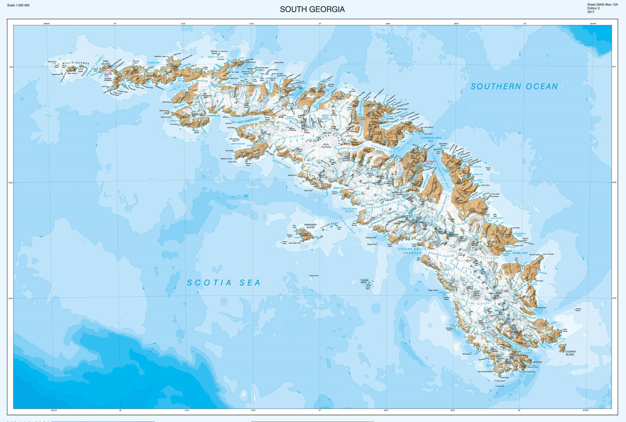
A team of cartographers at British Antarctic Survey (BAS) has re-produced a high-resolution updated map of the sub-antarctic island of South Georgia. The island, situated at 37°W 54°10’S is a haven for wildlife, a centre for wildlife and fisheries research and famous for the epic voyage by Sir Ernest Shackleton and his men just over a century ago.
Last updated in 2004, the map has new features including new bays and lakes created by recent glacier retreat. An interesting addition is a detailed map of the Shackleton Crossing, which is popular for mountaineers wishing to follow in the path of the great explorer’s 1916 expedition. This was produced in collaboration with the expedition and advisory panel at the Government of South Georgia and South Sandwich Islands (GSGSSI), who frequently advise visitors on routes across the island.

The new map of South Georgia features newly formed bays due to glacier retreat
BAS has an in-house mapping team which is responsible for producing paper and web maps of the polar regions for the UK, and works closely with UK researchers to provide detailed maps for field work. The South Georgia map is produced at a 1:200 000 scale.
The Shackleton Crossing (1:40 000) includes three higher resolution maps, including the more dangerous parts of the crossing, including The Razorback and Breakwind Gap, which have near-vertical descents, which the Shackleton trio Shackleton, Tom Crean and Frank Worsley slid down by tobogganing on their coiled ropes.
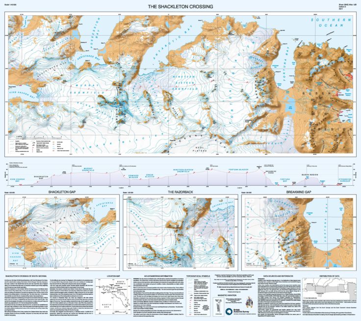
The new map also features The Shackleton Crossing
Head of the Mapping and Geographic Information Centre at BAS, Dr Adrian Fox says:
“We are really pleased with our new map of South Georgia, which will appeal to mountaineers and tourists visiting the island. It’s important to frequently update maps of this region as the environment is changing. For instance, on the north side of the island there is the newly formed Twitcher Bay, formed due to the retreat of Twitcher Glacier of over 4 km since the last edition of the map, and the extension of Cumberland West Bay by more than 6 km due to the retreat of Neumayer Glacier.”
The South Georgia and The Shackleton Crossing map is available for sale at several outlets including Stanfords map store in London (www.stanfords.co.uk, email: sales@stanfords.co.uk), the UK Antarctic Heritage Trust (www.ukaht.org/shop, email: sales@ukaht.org) and the post office on South Georgia. In addition, much of the map data is freely available to download from the South Georgia GIS and can be found here: www.sggis.gov.gs
This portal is the place to view, query and download South Georgia-related data and was built at BAS using open-source software. Version 3 was released in spring 2017 and includes substantially updated topographic data, as well as the location of visitor sites and wildlife colonies.
The new map is on sale now
Shackleton’s Crossing of South Georgia:
At 3.00 am on 19th May 1916 Sir Ernest Shackleton, with Frank Worsley and Tom Crean, set off to make the first crossing of the interior of South Georgia. Their ship, Endurance, had been crushed in the Weddell Sea and the crew had made their way to Elephant Island. No-one knew where they were, so Shackleton decided to go for help, beginning one of the epic journeys of polar exploration.
With five companions, he had crossed 1300 km of stormy ocean in the lifeboat James Caird to land in King Haakon Bay on the south side of South Georgia. The three men were now setting out across the mountains and glaciers of the unknown interior of the island to the whaling stations in Stromness Bay. The other three men, Tim McCarthy, Harry McNish and John Vincent, remained at King Haakon Bay to await rescue.
Shackleton’s equipment consisted of just enough food and fuel for three days, a Primus stove, only 15 m of rope, a makeshift ice axe and screws in their boots for grip. They carried two compasses, binoculars, a chronometer and, crucially, a blue-print copy of a sketch map prepared by the 1911 German Deutschland Expedition.
According to the map, the distance was about 27 km, but was far from straightforward with three major obstacles to cross. There was always the thought that failure to reach the whaling stations would preclude rescue of the remaining men at King Haakon Bay and Elephant Island.
Still suffering the effects of the 16-day crossing from Elephant Island, they made slow progress towards the Murray Snowfield, hampered by knee-deep soft snow which made for heavy going.
The first difficulty was crossing The Ridgeback. At first repelled by the precipices down to Compass Glacier, they eventually crossed at the most northerly col. In fading light they chanced their luck, sliding down using the coiled rope as a toboggan.
They then made good progress across Nineteen-Sixteen Snowfield, with the moon rising behind Wilckens Peaks to light the way towards Fortuna Glacier.
Exhausted, they became confused and mistook Fortuna Bay for Stromness Bay and started to descend Turnback Glacier. Eventually they realised their mistake and wearily headed towards the jagged peaks of Breakwind Ridge, aiming for the col now called Breakwind Gap. Here, they recognised Busen Point in the distance and faintly heard the steam whistle at one of the whaling stations calling the men to work.
The descent of Breakwind Ridge was steep and dangerous with their minimal equipment, but once the trio had made the shore of Fortuna Bay, they were on the last stage of the journey. They were heading towards Stromness, as the easiest to reach, when Tom Crean suddenly sank up to his waist in Crean Lake. When they reached the final ridge they could see the whaling station and a whale-catcher steaming into the bay, yet there was one more hurdle to overcome. To avoid steep and icy slopes they followed a stream, but this soon entered a deep gully. Unable to retreat they clambered down what is now called Shackleton Falls with the aid of the rope.
Eventually, they staggered into Stromness as, in Worsley’s words, ‘a terrible trio of scarecrows’. Against the odds they had reached their destination and the men on Elephant Island and at King Haakon Bay would be saved.
Information text about Shackleton’s crossing of South Georgia reproduced by permission of Robert Burton.