Surface exposure dating

Column chemistry for extracting 10Be from quartz-bearing rock samples
What can surface exposure dating tell us about ice sheet history?
Information on the shape and size of the Antarctic Ice Sheets over the past 20,000 years is contained within rocks deposited on the surface of Antarctica as the ice sheet has retreated and thinned since that time. Surface exposure dating involves collecting such rocks and measuring the abundance of an isotope concentrated within their upper surfaces, which acts as a chemical signal for the length of time since the rock was last covered by ice.
The ANiSEED project will collect this information from a range of heights above today’s ice surface in the western Amundsen Sea Embayment of Antarctica. Thus we will be able to tell how rapidly that part of the West Antarctic Ice Sheet (WAIS) has thinned, and when the thinning started and stopped.
As well as establishing the history of this part of the WAIS, this approach will also give us insight into the significance of ice sheet changes recorded and widely publicised over the past decade. By comparing the retreat history of glaciers in the western and eastern parts of the Amundsen Sea Embayment, we will learn how different parts of the region are likely to respond to future environmental change.
How does surface exposure dating work?
This technique involves measuring the abundance of isotopes that are produced within rock surfaces when they are exposed to cosmic radiation. Ice cover blocks the penetration of cosmic radiation, halting production of such isotopes; their abundance in a rock therefore gives a measure of the time since ice retreated: the ‘exposure age’.
This diagram, showing thinning of an ice sheet from the Last Glacial Maximum (LGM) to present day, helps to visualise how this works:
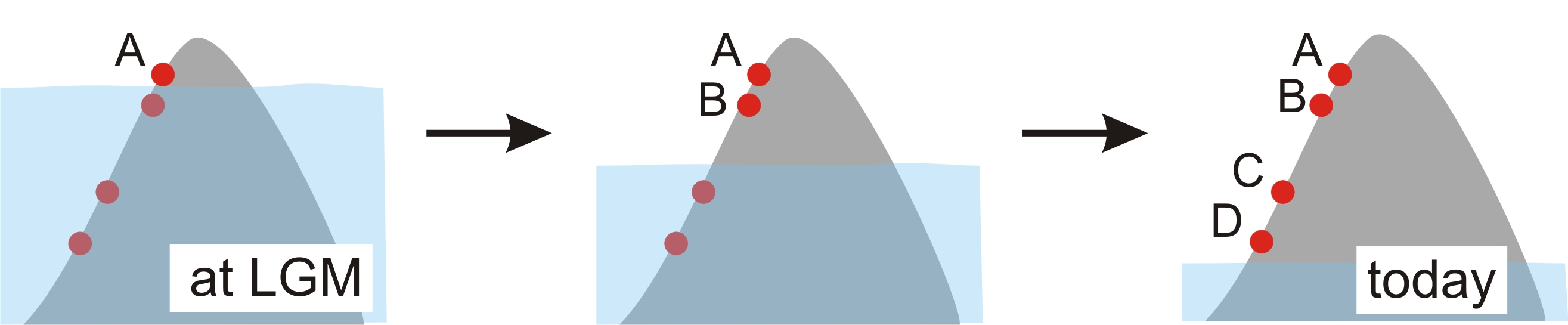
When an ice sheet thins, rocks transported within it (erratics – shown here as red circles) are left perched on mountainsides – known as ‘nunataks’ when surrounded by ice – at a range of heights above the modern ice sheet surface. Thus nunataks act as a ‘dipstick’ for the former height of the ice sheet surface. Exposure ages measured on the erratics can provide an extremely detailed record of the progress of ice sheet thinning.
Erratics are often preferable to bedrock for this technique because they are usually eroded during glacial transport, removing isotopes produced during any previous exposure. On a bedrock surface, erosion sufficient to remove those isotopes is much less likely to occur. Bedrock is therefore more likely to yield an exposure history that represents intermittent exposure between multiple periods of ice cover (termed ‘pre-exposure’), rather than the timing of the last ice retreat.
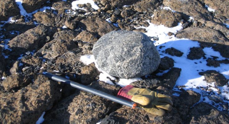
Erratic cobble, eroded to a rounded shape by transport within ice, perched on bedrock surface in the Hudson Mountains, West Antarctica
How is the ANiSEED project different from others that have utilised surface exposure dating?
Surface exposure dating has been used in many studies in Antarctica; the key difference in the ANiSEED project is our focus on producing a record with greater precision and higher-resolution. Innovations in the 10Be dating technique – pioneered by our Project Partner Joerg Schaefer who heads the Lamont-Doherty Earth Observatory Cosmogenic Dating Group – now permit fluctuations in the rate of ice sheet thinning over centuries (rather than millennia), and potentially decades, to be constrained with much-improved precision.