A British Antarctic Survey team has just returned from a three-week science cruise with National Geographic on board the RRS James Clark Ross (JCR) around Ascension Island’s seamounts. This five-part blog, today by data manager Floyd Howard, provides an insight into the vital role of scientific research in informing conservation policy.
Thursday 1 June – mapping Un-named seamount
My alarm goes off, it’s midnight and time to get up. I should be grumpy but I have that excited anticipation that I remember getting before Christmas as a kid. I’m lucky enough to be on NatGeo Pristine Sea’s Ascension seamounts expedition and we are about to start mapping the last, unnamed seamount of the expedition. We scientists, not the most creative of folk, call the seamount “Un-named”!
To the best of our knowledge this remote seamount, approximately 300 kilometers south east of Ascension Island in the South Atlantic Ocean, has never been mapped before. The other two, Harris-Stewart and Grattan, were visited briefly by US scientists in the mid 1980s. Everything that we are about to illuminate with the JCR’s sonar will be completely new. The current bathymetry maps were derived from gravity anomalies measured from space and as a result we only know the seamount as a coarse rounded mound – rising from 3400m to around 230 m below the surface. To map Un-named, the ship’s master is cautious, and circles around from deep to shallow, always within our previous circuit’s sonar coverage. This is an unchartered underwater volcano after all!
We use sound to ‘see’ and map the seafloor, just as a bat navigates in a dark cave. In the deep ocean, light doesn’t penetrate very far and is quickly absorbed by the water; soundwaves fare much better. The JCR has a multibeam sonar fitted to the hull of the ship that sends out a fan of sound 70° to the port and starboard beneath the vessel. In deepest parts of the ocean this fan of sound can cover a swathe up to 30 km wide under the ship; in 100 m of water this fan narrows to just 400m. The fan of sound contains 432 individual beams that bounce off the seafloor back to the ship. The receiver, also mounted to the hull of the JCR, records the time, strength and angle that each beam of sound takes as it leaves and returns to the ship.
We have instruments on board which constantly measure how the ship rolls and pitches around as it is battered by wind and waves, as well as a GPS which gives us our location on the Earth’s surface. We combine these measurements wiht the speed of sound through the water (which we determine using a CTD) to turn the travel time and angle of the sound beams into depth measurements at specific locations on the seafloor. All this is done in real time. The strength of the returned sound further tells scientists something of the composition of the seafloor with ‘hard’ rocky seafloor reflecting a stronger sound signal back than ‘soft’ unconsolidated sediment. Think of how high a tennis ball bounces on sand (soft) versus pavement (hard).
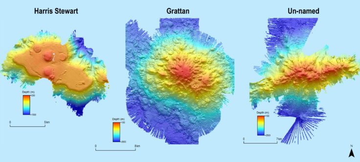
Final maps of the three Ascension seamounts
After a night of tracing around what was a vague and coarse lump on the satellite bathymetry, the multibeam sonar has illuminated in detail for the first time Un-named’s true shape and form. In contrast to the massive rounded form of Grattan, and Harris-Stewart’s steep-sided plateau studded with several volcanic cones, Un-named was revealed to be a dramatic long and narrow seamount, with many individual peaks along its spine. It was also the shallowest of the seamounts mapped on this expedition rising to just 68 m below the ocean surface at not one but two locations.
These maps will prove essential for the success of the next stage of the cruise, targeted video and biological sampling of the summit and water column around the seamount. This information will help the Ascension Island government scientists answer important questions about the influence of these seamount ecosystems they manage.