Introduction
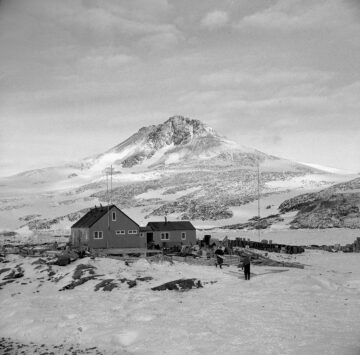
The base at Horseshoe Island was established by the Falkland Islands Dependencies Survey in 1955. This was part of the push to increase UK scientific activity ahead of International Geophysical Year, 1957-58, with a number of bases opened during this period. This included Anvers Island (Base N), also in Marguerite Bay, which was opened that same year. Horseshoe Island was primarily used for geology and survey, and provided meteorological observations that linked a chain of met stations. The combined survey task of Horseshoe Island and Detaille Island (Base W) was to establish a ground control network for the air photography being carried out by the Falkland Islands Dependencies Aerial Survey Expedition (FIDASE), 1955-57.
Location
Position: Lat. 67° 48′ S, Long. 67° 17′ W
General location: Sally Cove, Horseshoe Island, Bourgeois Fjord, Marguerite Bay
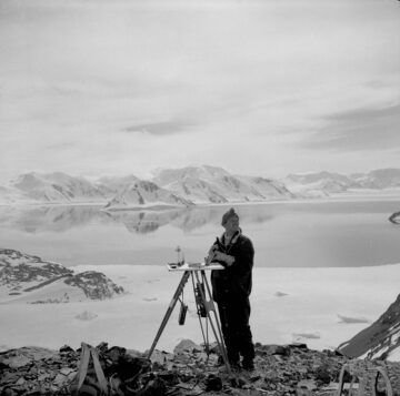
Purpose
Survey, geology and meteorology.
Occupied
- 11 March 1955 – 21 August 1960
- 7 March 1969 – 11 July 1969
Closed in 1960 when personnel transferred to Stonington Island (Station E). Reopened briefly in 1969 to complete local survey work.
Buildings
Unnamed.
Memorials
S E Black, D Statham and G Stride, 27 May 1958: single cross on Beacon Hill.
Current status
Closed. Used occasionally by BAS personnel on field trips from Rothera (Station R). Site cleaned up by BAS Mar 1995. Designated as Historic Site No. 63 under the Antarctic Treaty, 19 May 1995 (includes Blaiklock Island refuge). Building conservation work undertaken in Mar 1997. Inspected for BAS by a conservation architect in Jan 2007. It has been managed by UKAHT since Oct 2014 under a Memorandum of Understanding with BAS.
Associated refuge
For full listing of all station histories, see History of British stations and refuges.