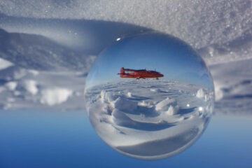
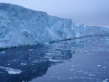
Understanding Greenland’s changing ice
GIANT is a pioneering science project that will test the potential for early warning of a critical climate tipping point.
My main interest lies in investigation of the geological and tectonic evolution of Antarctica, using airborne geophysical data. This has led to publications in a broad range of fields including crustal architecture, mountain uplift, magma emplacement, and geothermal heat flux. I have also worked and published on the geomorphological investigation of the hidden sub-ice topography of Antarctica, and deriving the bathymetry hidden beneath floating ice shelves from gravity data.
Since completing my DPhil at Oxford University in 2007 on Gravity Anomalies, Flexure, and the Long-term Rigidity of the Continental Lithosphere, I have worked at the British Antarctic Survey as an aerogeophysicist. My role includes collection, processing and interpretation of a range of airborne geophysical data, including magnetic, gravity and radar data. I have participated in seven Antarctic field seasons, including working as field science leader, responsible for flight planning, prioritisation and overseeing data quality control. This work has included successful collaboration with a range of international and UK academic partners. I also helped run the successful UK airborne surveys, and have taken part in an Antarctic marine Geophysical cruse.
Most recently I was the lead scientist for the SWARM project, demonstrating the use of the Windracers Ultra UAV for environmental science data collection. This project confirmed that large UAVs can successfully collect a range of environmental data over a relativley wide area, while operating alongside traditional crewed aviation in Antarctica, paving the way for new and innovative methods of data collection into the future.
Jordan, T. A., F. Ferraccioli and R. Forsberg (2022). “An embayment in the East Antarctic basement constrains the shape of the Rodinian continental margin.” Communications Earth & Environment 3(1): 52. https://doi.org/10.1038/s43247-022-00375-z
Jordan, T. A., Riley, T. R. and Siddoway, C. S., 2020. The geological history and evolution of West Antarctica. Nature Reviews Earth & Environment 1(2): 117-133. https://doi.org/10.1038/s43017-019-0013-6
Jordan, T. A., Martin, C., Ferraccioli, F., Matsuoka, K., Corr, H., Forsberg, R., Olesen, A., and Siegert, M., 2018, Anomalously high geothermal flux near the South Pole: Scientific Reports, v. 8, no. 1, p. 16785. https://doi.org/10.1038/s41598-018-35182-0
Jordan, Tom and Becker, David. (2018) “Investigating the distribution of magmatism at the onset of Gondwana breakup with novel strapdown gravity and aeromagnetic data”. Physics of the Earth and Planetary Interiors, 282. 77-88. https://doi.org/10.1016/j.pepi.2018.07.007
Jordan, Tom, Ferraccioli, Fausto, Leat, Philip. (2017) “New geophysical compilations link crustal block motion to Jurassic extension and strike-slip faulting in the Weddell Sea Rift System of West Antarctica”. Gondwana Research, 42. 29-48. 10.1016/j.gr.2016.09.009
Jordan, T. A., F. Ferraccioli, N. Ross, H. F. J. Corr, P. T. Leat, R. G. Bingham, D. M. Rippin, A. le Brocq and M. J. Siegert (2013). “Inland extent of the Weddell Sea Rift imaged by new aerogeophysical data.” Tectonophysics 585 (0): 137-160. https://doi.org/10.1016/j.tecto.2012.09.010
Jordan, T. A., F. Ferraccioli, A. Armadillo and E. Bozzo (2012). “Crustal architecture of the Wilkes Subglacial Basin in East Antarctica, as revealed from airborne gravity data ” Tectonophysics 585: 196-206, doi.org/110.1016/j.tecto.2012.1006.1041.
Jordan, T. A., F. Ferraccioli, H. Corr, A. G. C. Graham, A. Armadillo and E. Bozzo (2010). “Hypothesis for mega-outburst flooding from a palaeo-subglacial lake beneath the East Antarctic Ice Sheet.” Terra Nova 22: 283-289, DOI: 210.1111/j.1365-3121.2010.00944.x.
Jordan, T. A., F. Ferraccioli, D. G. Vaughan, J. W. Holt, H. Corr, D. D. Blankenship and T. M. Diehl (2010). “Aerogravity evidence for major crustal thinning under the Pine Island Glacier region (West Antarctica).” Geol. Soc. Am. Bull. 122: 714-726, https://doi.org/10.1130/B26417.1.
Jordan, T. A. and A. B. Watts (2005). “Gravity anomalies, flexure and the elastic thickness structure of the India–Eurasia collisional system.” Earth Planet. Sci. Lett. 236: 732-750. https://doi.org/10.1016/j.epsl.2005.05.036
Ross, Neil. Sanderson, Rebecca J. Kulessa, Bernd. Siegert, Martin. Paxman, Guy J.G. Nichols, Keir A. Siegfried, Matthew R. Jamieson, Stewart S.R. Bentley, Michael J. Jordan, Tom A. ORCID record for Jordan, Tom A.. Batchelor, Christine L. Small, David. Eisen, Olaf. Winter, Kate. Bingham, Robert G. Callard, S. Louise. Carr, Rachel. Dow, Christine F. Fricker, Helen A. Hill, Emily. Hills, Benjamin H. Hofstede, Coen. Jeofry, Hafeez. Napoleoni, Felipe. Sauthoff, Wilson. (2026) Review article: The Foundation-Patuxent-Academy ice stream system, Antarctica.
Paxman, Guy J.G. ORCID record for Paxman, Guy J.G.. Jordan, Tom A. ORCID record for Jordan, Tom A.. Bentley, Michael J. ORCID record for Bentley, Michael J.. Small, David ORCID record for Small, David. Jamieson, Stewart S. R. ORCID record for Jamieson, Stewart S. R.. Steinhage, Daniel ORCID record for Steinhage, Daniel. (2026) Subglacial Topography of Coats Land Records Post‐Gondwanan Landscape Evolution and Early Ice‐Sheet Behavior in East Antarctica.
Archibald, Emily J. Marschalek, James W. Muxworthy, Adrian R. Riley, Teal ORCID record for Riley, Teal. Hillenbrand, Claus-Dieter ORCID record for Hillenbrand, Claus-Dieter. Jordan, Tom ORCID record for Jordan, Tom. Vermeesch, Pieter. Flowerdew, Michael J. Siegert, Martin. Hodgson, Dominic A. ORCID record for Hodgson, Dominic A.. van de Flierdt, Tina. (2026) Geochemical characterisation of the Ellsworth-Whitmore Mountains crustal block: a critical piece in the puzzle to unravel ice retreat in West Antarctica.
Monteath, Alistair J. ORCID record for Monteath, Alistair J.. Young, Emma F. ORCID record for Young, Emma F.. Dawson, Hannah R.S. Jensen, Britta J.L. Smellie, John L. Manning, Christina J. Riley, Teal R. ORCID record for Riley, Teal R.. Jordan, Tom A. ORCID record for Jordan, Tom A.. Roberts, Stephen J. ORCID record for Roberts, Stephen J.. (2025) Major-Minor-Trace Element Analyses and Oceanographic Modeling Confirms Circumpolar Transport of the 1962 Protector Shoal Pumice Raft.
Bingham, Robert G. Bodart, Julien A. Cavitte, Marie G.P. Chung, Ailsa. Sanderson, Rebecca J. Sutter, Johannes C.R. Eisen, Olaf. Karlsson, Nanna B. MacGregor, Joseph A. Ross, Neil. Young, Duncan A. Ashmore, David W. Born, Andreas. Chu, Winnie. Cui, Xiangbin. Drews, Reinhard. Franke, Steven. Goel, Vikram. Goodge, John W. Henry, A. Clara J. Hermant, Antoine. Hills, Benjamin H. Holschuh, Nicholas. Koutnik, Michelle R. Leysinger Vieli, Gwendolyn J.-M.C. MacKie, Emma J. Mantelli, Elisa. Martín, Carlos ORCID record for Martín, Carlos. Ng, Felix S. L. Oraschewski, Falk M. Napoleoni, Felipe. Parrenin, Frédéric. Popov, Sergey V. Rieckh, Therese. Schlegel, Rebecca. Schroeder, Dustin M. Siegert, Martin J. Tang, Xueyuan. Teisberg, Thomas O. Winter, Kate. Yan, Shuai. Davis, Harry. Dow, Christine F. Fudge, Tyler J. Jordan, Tom A. ORCID record for Jordan, Tom A.. Kulessa, Bernd. Matsuoka, Kenichi. Nyqvist, Clara J. Rahnemoonfar, Maryam. Siegfried, Matthew R. Singh, Shivangini. Višnjević, Vjeran. Zamora, Rodrigo. Zuhr, Alexandra. (2025) Review article: AntArchitecture – building an age–depth model from Antarctica’s radiostratigraphy to explore ice-sheet evolution.
Jordan, Tom A. ORCID record for Jordan, Tom A.. Johnson, Joanne S. ORCID record for Johnson, Joanne S.. Riley, Teal R. ORCID record for Riley, Teal R.. Conrad, Ethan. Carter, Andrew. (2025) Subglacial geology and palaeo flow of Pine Island Glacier from combining glacial erratics with geophysics.
Jordan, Tom A. ORCID record for Jordan, Tom A.. Lowe, Maximilian ORCID record for Lowe, Maximilian. Riley, Teal R. ORCID record for Riley, Teal R.. (2025) New Insights Into Western Antarctic Peninsula Magmatism From Joint Inversion of UAV Magnetic and Gravity Data.
Paxman, Guy J. G. ORCID record for Paxman, Guy J. G.. Jamieson, Stewart S.R. ORCID record for Jamieson, Stewart S.R.. Ross, Neil ORCID record for Ross, Neil. Bentley, Michael J. ORCID record for Bentley, Michael J.. Carter, Charlotte M. ORCID record for Carter, Charlotte M.. Jordan, Tom A. ORCID record for Jordan, Tom A.. Cui, Xiangbin ORCID record for Cui, Xiangbin. Lang, Shinan ORCID record for Lang, Shinan. Sugden, David E. Siegert, Martin J. (2025) Extensive fluvial surfaces at the East Antarctic margin have modulated ice-sheet evolution.
Jordan, Tom ORCID record for Jordan, Tom. Robinson, Carl ORCID record for Robinson, Carl. Reed, Tom. Toomey, Rebecca. Jelev, Nickolay. Waters, Jonathon. Fenney, Nathan ORCID record for Fenney, Nathan. Weiss, Alexandra ORCID record for Weiss, Alexandra. Lowe, Maximilian ORCID record for Lowe, Maximilian. (2025) Successful deployment of a large uncrewed aerial vehicle for multidisciplinary science from Rothera Research Station, Antarctica: 2024 season overview and lessons learned.
Arenas-Pingarrón, Álvaro ORCID record for Arenas-Pingarrón, Álvaro. Brisbourne, Alex M. ORCID record for Brisbourne, Alex M.. Martín, Carlos ORCID record for Martín, Carlos. Corr, Hugh F.J. Robinson, Carl ORCID record for Robinson, Carl. Jordan, Tom A. ORCID record for Jordan, Tom A.. Brennan, Paul V. (2025) An alternative representation of Synthetic Aperture Radar images as an aid to the interpretation of englacial observations.
Pritchard, Hamish D. ORCID record for Pritchard, Hamish D.. Fretwell, Peter T. ORCID record for Fretwell, Peter T.. Fremand, Alice C. ORCID record for Fremand, Alice C.. Bodart, Julien A. ORCID record for Bodart, Julien A.. Kirkham, James D. ORCID record for Kirkham, James D.. Aitken, Alan. Bamber, Jonathan. Bell, Robin. Bianchi, Cesidio. Bingham, Robert G. ORCID record for Bingham, Robert G.. Blankenship, Donald D. Casassa, Gino. Christianson, Knut. Conway, Howard. Corr, Hugh F.J. Cui, Xiangbin. Damaske, Detlef. Damm, Volkmar. Dorschel, Boris ORCID record for Dorschel, Boris. Drews, Reinhard ORCID record for Drews, Reinhard. Eagles, Graeme. Eisen, Olaf ORCID record for Eisen, Olaf. Eisermann, Hannes. Ferraccioli, Fausto ORCID record for Ferraccioli, Fausto. Field, Elena ORCID record for Field, Elena. Forsberg, René. Franke, Steven ORCID record for Franke, Steven. Goel, Vikram ORCID record for Goel, Vikram. Gogineni, Siva Prasad. Greenbaum, Jamin ORCID record for Greenbaum, Jamin. Hills, Benjamin. Hindmarsh, Richard C.A. ORCID record for Hindmarsh, Richard C.A.. Hoffman, Andrew O. Holschuh, Nicholas. Holt, John W. Humbert, Angelika ORCID record for Humbert, Angelika. Jacobel, Robert W. Jansen, Daniela. Jenkins, Adrian. Jokat, Wilfried. Jong, Lenneke ORCID record for Jong, Lenneke. Jordan, Tom A. ORCID record for Jordan, Tom A.. King, Edward C. ORCID record for King, Edward C.. Kohler, Jack. Krabill, William. Maton, Joséphine. Gillespie, Mette Kusk. Langley, Kirsty. Lee, Joohan ORCID record for Lee, Joohan. Leitchenkov, German. Leuschen, Cartlon. Luyendyk, Bruce ORCID record for Luyendyk, Bruce. MacGregor, Joseph A. ORCID record for MacGregor, Joseph A.. MacKie, Emma. Moholdt, Geir. Matsuoka, Kenichi ORCID record for Matsuoka, Kenichi. Morlighem, Mathieu ORCID record for Morlighem, Mathieu. Mouginot, Jérémie ORCID record for Mouginot, Jérémie. Nitsche, Frank O. ORCID record for Nitsche, Frank O.. Nost, Ole A. Paden, John ORCID record for Paden, John. Pattyn, Frank. Popov, Sergey. Rignot, Eric ORCID record for Rignot, Eric. Rippin, David M. ORCID record for Rippin, David M.. Rivera, Andrés ORCID record for Rivera, Andrés. Roberts, Jason L. ORCID record for Roberts, Jason L.. Ross, Neil ORCID record for Ross, Neil. Ruppel, Antonia. Schroeder, Dustin M. Siegert, Martin J. ORCID record for Siegert, Martin J.. Smith, Andrew ORCID record for Smith, Andrew. Steinhage, Daniel. Studinger, Michael ORCID record for Studinger, Michael. Sun, Bo. Tabacco, Ignazio. Tinto, Kirsty J. ORCID record for Tinto, Kirsty J.. Urbini, Stefano. Vaughan, David G. ORCID record for Vaughan, David G.. Wilson, Douglas S. Young, Duncan A. Zirizzotti, Achille. (2025) Bedmap3 updated ice bed, surface and thickness gridded datasets for Antarctica.
Sanderson, Rebecca J. Ross, Neil. Winter, Kate. Bingham, Robert G. Callard, S. Louise. Jordan, Tom A. ORCID record for Jordan, Tom A.. Young, Duncan A. (2024) Dated radar-stratigraphy between Dome A and South Pole, East Antarctica: old ice potential and ice sheet history.
Jordan, Tom A. ORCID record for Jordan, Tom A.. Riley, Teal ORCID record for Riley, Teal. (2024) Reinvestigating the Dufek Intrusion, through joint gravity and magnetic models.
Lowe, Maximilian ORCID record for Lowe, Maximilian. Jordan, Tom ORCID record for Jordan, Tom. Moorkamp, Max. Ebbing, Jörg. Green, Chris. Lösing, Mareen. Riley, Teal ORCID record for Riley, Teal. Larter, Robert ORCID record for Larter, Robert. (2024) The 3D Crustal Structure of the Wilkes Subglacial Basin, East Antarctica, Using Variation of Information Joint Inversion of Gravity and Magnetic Data.
Rodriguez-Morales, F. Paden, J. Escalera Mendoza, A. S. Hale, R. Karidi, K. T. Schroeder, B. Shang, J. Talasila, H. Robinson, C. ORCID record for Robinson, C.. Jordan, T. ORCID record for Jordan, T.. Nicholls, K. ORCID record for Nicholls, K.. (2024) An UWB UHF Ice-Penetreating Radar for the Thwaites Melt Project.
Lowe, Maximilian ORCID record for Lowe, Maximilian. Jordan, Tom ORCID record for Jordan, Tom. Ebbing, Jörg. Koglin, Nikola. Ruppel, Antonia. Moorkamp, Max. Läufer, Andreas. Green, Chris. Liebsch, Jonas. Ginga, Mikhail. Larter, Robert ORCID record for Larter, Robert. (2024) Comparing geophysical inversion and petrophysical measurements for northern Victoria Land, Antarctica.
Carter, Charlotte M. Bentley, Michael J. Jamieson, Stewart S. R. Paxman, Guy J.G. Jordan, Tom A. ORCID record for Jordan, Tom A.. Bodart, Julien A. ORCID record for Bodart, Julien A.. Ross, Neil. Napoleoni, Felipe. (2024) Extensive palaeo-surfaces beneath the Evans–Rutford region of the West Antarctic Ice Sheet control modern and past ice flow.
Diehl, T.M. Blankenship, D.D. Holt, J.W. Young, D.A. Jordan, T.A. ORCID record for Jordan, T.A.. Ferraccioli, F. ORCID record for Ferraccioli, F.. Editors: Cooper, A.K. Raymond, C.R (2024) Locating subglacial sediments across West Antarctica with isostatic gravity anomalies.
Sanderson, Rebecca J. Winter, Kate. Callard, S. Louise. Napoleoni, Felipe. Ross, Neil. Jordan, Tom A. ORCID record for Jordan, Tom A.. Bingham, Robert G. (2023) Englacial architecture of Lambert Glacier, East Antarctica.
Aitken, A.R.A. Li, L. Kulessa, B. Schroeder, D. Jordan, T.A. ORCID record for Jordan, T.A.. Whittaker, J.M. Anadakrishnan, S. Dawson, E.J. Wiens, D.A. Eisen, O. Siegert, M.J. (2023) Antarctic sedimentary basins and their influence on ice-sheet dynamics.
Arenas-Pingarrón, Álvaro ORCID record for Arenas-Pingarrón, Álvaro. Corr, Hugh F.J. Robinson, Carl ORCID record for Robinson, Carl. Jordan, Tom A. ORCID record for Jordan, Tom A.. Brennan, Paul V. (2023) Polarimetric airborne scientific instrument, mark 2, an ice‐sounding airborne synthetic aperture radar for subglacial 3D imagery.
Jordan, Tom A. ORCID record for Jordan, Tom A.. Thompson, Sarah. Kulessa, Bernd. Ferraccioli, Fausto ORCID record for Ferraccioli, Fausto. (2023) Geological sketch map and implications for ice flow of Thwaites Glacier, West Antarctica, from integrated aerogeophysical observations.
Lowe, Maximilian ORCID record for Lowe, Maximilian. Mather, Ben. Green, Chris. Jordan, Tom A. ORCID record for Jordan, Tom A.. Ebbing, Jörg. Larter, Robert ORCID record for Larter, Robert. (2022) Anomalously high heat flow regions beneath the Transantarctic Mountains and Wilkes Subglacial Basin in East Antarctica inferred from Curie depth.
Frémand, Alice C. ORCID record for Frémand, Alice C.. Fretwell, Peter ORCID record for Fretwell, Peter. Bodart, Julien A. Pritchard, Hamish D. ORCID record for Pritchard, Hamish D.. Aitken, Alan. Bamber, Jonathan L. Bell, Robin. Bianchi, Cesido. Bingham, Robert G. Blankenship, Donald D. Casassa, Gino. Catania, Ginny. Christianson, Knut. Conway, Howard. Corr, Hugh F.J. Cui, Xiangbin. Damaske, Detlef. Damm, Volkmar. Drews, Reinhard. Eagles, Graeme. Eisen, Olaf. Eisermann, Hannes. Ferraccioli, Fausto ORCID record for Ferraccioli, Fausto. Field, Elena ORCID record for Field, Elena. Forsberg, René. Franke, Steven. Fujita, Shuji. Gim, Yonggyu. Goel, Vikram. Gogineni, Siva Prasad. Greenbaum, Jamin. Hills, Benjamin. Hindmarsh, Richard C.A. ORCID record for Hindmarsh, Richard C.A.. Hoffman, Andrew O. Holmlund, Per. Holschuh, Nicholas. Holt, John W. Horlings, Anneka N. Humbert, Anglika. Jacobel, Robert W. Jansen, Daniela. Jenkins, Adrian. Jokat, Wilfried. Jordan, Tom ORCID record for Jordan, Tom. King, Edward ORCID record for King, Edward. Kohler, Jack. Krabill, William. Langley, Kirsty. Lee, Joohan. Leitchenkov, German. Leuschen, Carlton. Luyendyk, Bruce. MacGregor, Joseph. MacKie, Emma. Matsuoka, Kenichi. Morlighem, Mathieu. Mouginot, Jérémie. Nitsche, Frank O. Nogi, Yoshifumi. Nost, Ole A. Paden, John. Pattyn, Frank. Popov, Sergey V. Rignot, Eric. Rippin, David M. Rivera, Andrés. Roberts, Jason. Ross, Neil. Ruppel, Anotonia. Schroeder, Dustin M. Siegert, Martin J. Smith, Andrew M. ORCID record for Smith, Andrew M.. Steinhage, Daniel. Studinger, Michael. Sun, Bo. Tabacco, Ignazio. Tinto, Kirsty. Urbini, Stefano. Vaughan, David ORCID record for Vaughan, David. Welch, Brian C. Wilson, Douglas S. Young, Duncan A. Zirizzotti, Achille. (2022) Antarctic Bedmap data: Findable, Accessible, Interoperable, and Reusable (FAIR) sharing of 60 years of ice bed, surface, and thickness data.
Hodgson, Dominic A. ORCID record for Hodgson, Dominic A.. Jordan, Tom A. ORCID record for Jordan, Tom A.. Ross, Neil ORCID record for Ross, Neil. Riley, Teal R. ORCID record for Riley, Teal R.. Fretwell, Peter ORCID record for Fretwell, Peter. (2022) Drainage and refill of an Antarctic Peninsula subglacial lake reveal an active subglacial hydrological network.
Jordan, Tom A. ORCID record for Jordan, Tom A.. Ferraccioli, Fausto ORCID record for Ferraccioli, Fausto. Forsberg, Rene. (2022) An embayment in the East Antarctic basement constrains the shape of the Rodinian continental margin.
Frémand, Alice C. ORCID record for Frémand, Alice C.. Bodart, Julien A. ORCID record for Bodart, Julien A.. Jordan, Tom A. ORCID record for Jordan, Tom A.. Ferraccioli, Fausto ORCID record for Ferraccioli, Fausto. Robinson, Carl ORCID record for Robinson, Carl. Corr, Hugh F.J. Peat, Helen J. ORCID record for Peat, Helen J.. Bingham, Robert G. Vaughan, David G. ORCID record for Vaughan, David G.. (2022) British Antarctic Survey’s aerogeophysical data: releasing 25 years of airborne gravity, magnetic, and radar datasets over Antarctica.
Constantino, Renata R. Tinto, Kirsty J. Bell, Robin E. Porter, David F. Jordan, Tom A. ORCID record for Jordan, Tom A.. (2020) Seafloor depth of George VI Sound, Antarctic Peninsula, from inversion of aerogravity data.
Hogan, Kelly A. ORCID record for Hogan, Kelly A.. Larter, Robert D. ORCID record for Larter, Robert D.. Graham, Alastair G.C. Arthern, Robert ORCID record for Arthern, Robert. Kirkham, James D. ORCID record for Kirkham, James D.. Totten Minzoni, Rebecca. Jordan, Tom A. ORCID record for Jordan, Tom A.. Clark, Rachel. Fitzgerald, Victoria. Wåhlin, Anna K. Anderson, John B. Hillenbrand, Claus-Dieter ORCID record for Hillenbrand, Claus-Dieter. Nitsche, Frank O. Simkins, Lauren. Smith, James ORCID record for Smith, James. Gohl, Karsten. Arndt, Jan Erik. Hong, Jongkuk. Wellner, Julia. (2020) Revealing the former bed of Thwaites Glacier using sea-floor bathymetry: implications for warm-water routing and bed controls on ice flow and buttressing.
Dunham, C.K. O’Donnell, J.P. Stuart, G W. Brisbourne, A.M. ORCID record for Brisbourne, A.M.. Rost, S. Jordan, T.A. ORCID record for Jordan, T.A.. Nyblade, A.A. Wiens, D.A. Aster, R.C. (2020) A joint inversion of receiver function and Rayleigh wave phase velocity dispersion data to estimate crustal structure in West Antarctica.
Ashmore, David W. Bingham, Robert G. Ross, Neil. Siegert, Martin J. Jordan, Tom ORCID record for Jordan, Tom. Mair, Douglas W.F. (2020) Englacial architecture and age‐depth constraints across the West Antarctic Ice Sheet.
Jordan, Tom A. ORCID record for Jordan, Tom A.. Porter, David. Tinto, Kirsty. Millan, Romain. Muto, Atsuhiro. Hogan, Kelly ORCID record for Hogan, Kelly. Larter, Robert D. ORCID record for Larter, Robert D.. Graham, Alastair G.C. Paden, John D. (2020) New gravity-derived bathymetry for the Thwaites, Crosson and Dotson ice shelves revealing two ice shelf populations.
Jordan, Tom A. ORCID record for Jordan, Tom A.. Riley, Teal R. ORCID record for Riley, Teal R.. Siddoway, Christine. (2020) The geological history and evolution of West Antarctica.
Riley, Teal ORCID record for Riley, Teal. Jordan, Tom ORCID record for Jordan, Tom. Leat, Philip. Curtis, Mike L. Millar, Ian. (2019) Magmatism of the Weddell Sea rift system in Antarctica: Implications for the age and mechanism of rifting and early stage Gondwana breakup.
Paxman, Guy J.G. Jamieson, Stewart S.R. Ferraccioli, Fausto ORCID record for Ferraccioli, Fausto. Jordan, Tom A. ORCID record for Jordan, Tom A.. Bentley, Michael J. Ross, Neil. Forsberg, René. Matsuoka, Kenichi. Steinhage, Daniel. Eagles, Graeme. Casal, Tania G. (2019) Subglacial geology and geomorphology of the Pensacola‐Pole Basin, East Antarctica.
Hodgson, Dominic ORCID record for Hodgson, Dominic. Jordan, Tom ORCID record for Jordan, Tom. De Rydt, Jan. Fretwell, Peter ORCID record for Fretwell, Peter. Seddon, Samuel. Becker, David. Hogan, Kelly ORCID record for Hogan, Kelly. Smith, Andy ORCID record for Smith, Andy. Vaughan, David ORCID record for Vaughan, David. (2019) Past and future dynamics of the Brunt Ice Shelf from seabed bathymetry and ice shelf geometry.
Burton-Johnson, Alex ORCID record for Burton-Johnson, Alex. Macpherson, C.G. Muraszko, J.R. Harrison, R.J. Jordan, Tom A. ORCID record for Jordan, Tom A.. (2019) Tectonic strain recorded by magnetic fabrics (AMS) in plutons, including Mt Kinabalu, Borneo: A tool to explore past tectonic regimes and syn-magmatic deformation.
Diez, Anja. Matsuoka, Kenichi. Jordan, Tom A. ORCID record for Jordan, Tom A.. Kohler, Jack. Ferraccioli, Fausto ORCID record for Ferraccioli, Fausto. Corr, Hugh F. Olesen, Arne V. Forsberg, René. Casal, Tania G. (2019) Patchy lakes and topographic origin for fast flow in the Recovery Glacier system, East Antarctica.
Jordan, T.A. ORCID record for Jordan, T.A.. Martin, C. ORCID record for Martin, C.. Ferraccioli, F. ORCID record for Ferraccioli, F.. Matsuoka, K. Corr, H. Forsberg, R. Olesen, A. Siegert, M. (2018) Anomalously high geothermal flux near the South Pole.
Jordan, Tom A. ORCID record for Jordan, Tom A.. Editors: Nuttall, Mark. Christensen, Torben R. Siegert, Martin (2018) Geological histories of polar environments.
Jordan, Tom A. ORCID record for Jordan, Tom A.. Becker, David. (2018) Investigating the distribution of magmatism at the onset of Gondwana breakup with novel strapdown gravity and aeromagnetic data.
Martos, Yasmina M. Jordan, Tom A. ORCID record for Jordan, Tom A.. Catalan, Manuel. Jordan, Thomas M. Bamber, Jonathan L. Vaughan, David G. ORCID record for Vaughan, David G.. (2018) Geothermal heat flux reveals the Iceland hotspot track underneath Greenland.
Golynsky, A.V. Ferraccioli, F. ORCID record for Ferraccioli, F.. Hong, J.K. Golynsky, D.A. von Frese, R.R.B. Young, D.A. Blankenship, D.D. Holt, J.W. Ivanov, S.V. Kiselev, A.V. Masolov, V.N. Eagles, G. Gohl, K. Jokat, W. Damaske, D. Finn, C. Aitken, A. Bell, R.E. Armadillo, E. Jordan, T.A. ORCID record for Jordan, T.A.. Greenbaum, J.S. Bozzo, E. Caneva, G. Forsberg, R. Ghidella, M. Galindo-Zaldivar, J. Bohoyo, F. Martos, Y.M. Nogi, Y. Quartini, E. Kim, H.R. Roberts, J.L. (2018) New magnetic anomaly map of the Antarctic.
Winter, Kate. Ross, Neil. Ferraccioli, Fausto ORCID record for Ferraccioli, Fausto. Jordan, Tom A. ORCID record for Jordan, Tom A.. Corr, Hugh F.J. Forsberg, René. Matsuoka, Kenichi. Olesen, Arne V. Casal, Tania G. (2018) Topographic steering of enhanced ice flow at the bottleneck between East and West Antarctica.
Diez, Anja. Matsuoka, Kenichi. Ferraccioli, Fausto ORCID record for Ferraccioli, Fausto. Jordan, Tom A. ORCID record for Jordan, Tom A.. Corr, Hugh F. Kohler, Jack. Olesen, Arne V. Forsberg, René. (2018) Basal settings control fast ice flow in the Recovery/Slessor/Bailey Region, East Antarctica.
Martos, Yasmina M. Catalan, Manuel. Jordan, Tom A. ORCID record for Jordan, Tom A.. Golynsky, Alexander. Golynsky, Dmitry. Eagles, Graeme. Vaughan, David G. ORCID record for Vaughan, David G.. (2017) Heat flux distribution of Antarctica unveiled.
Leat, Philip T. Jordan, Tom A. ORCID record for Jordan, Tom A.. Flowerdew, Michael J. Riley, Teal R. ORCID record for Riley, Teal R.. Ferraccioli, Fausto ORCID record for Ferraccioli, Fausto. Whitehouse, Martin J. (2017) Jurassic high heat production granites associated with the Weddell Sea rift system, Antarctica..
Forsberg, Rene. Olesen, Arne V. Ferraccioli, Fausto ORCID record for Ferraccioli, Fausto. Jordan, Tom A. ORCID record for Jordan, Tom A.. Matsuoka, Kenichi. Zakrajsek, Andres. Ghidella, Marta. Greenbaum, Jamin S. Editors: Siegert, M.J. Jamieson, S.S.R. White, D.A (2017) Exploring the Recovery Lakes region and interior Dronning Maud Land, East Antarctica, with airborne gravity, magnetic and radar measurements.
Wrona, Thilo. Wolovick, Michael J. Ferraccioli, Fausto ORCID record for Ferraccioli, Fausto. Corr, Hugh. Jordan, Tom ORCID record for Jordan, Tom. Siegert, Martin J. Editors: Siegert, M.J. Jamieson, S.S.R. White, D.A (2017) Position and variability of complex structures in the central East Antarctic Ice Sheet.
Paxman, Guy J.G. Jamieson, Stewart S.Rr. Ferraccioli, Fausto ORCID record for Ferraccioli, Fausto. Bentley, Michael J. Forsberg, Rene. Ross, Neil. Watts, Anthony B. Corr, Hugh F.J. Jordan, Tom A. ORCID record for Jordan, Tom A.. (2017) Uplift and tilting of the Shackleton Range in East Antarctica driven by glacial erosion and normal faulting.
Jordan, Tom ORCID record for Jordan, Tom. Ferraccioli, Fausto ORCID record for Ferraccioli, Fausto. Leat, Philip. (2016) New geophysical compilations link crustal block motion to Jurassic extension and strike-slip faulting in the Weddell Sea Rift System of West Antarctica.
Jones, David H. Jordan, Tom A. ORCID record for Jordan, Tom A.. Robinson, Carl ORCID record for Robinson, Carl. (2016) An avionics platform for multi-instrument survey navigation.
Paxman, G.J.G. Watts, A.B. Ferraccioli, F. ORCID record for Ferraccioli, F.. Jordan, T.A. ORCID record for Jordan, T.A.. Bell, R.E. Jamieson, S.S.R. Finn, C.A. (2016) Erosion-driven uplift in the Gamburtsev Subglacial Mountains of East Antarctica.
Scheinert, M. Ferraccioli, F. ORCID record for Ferraccioli, F.. Schwabe, J. Bell, R. Studinger, M. Damaske, D. Jokat, W. Aleshkova, N. Jordan, T. ORCID record for Jordan, T.. Leitchenkov, G. Blankenship, D.D. Damiani, T.M. Young, D. Cochran, J.R. Richter, T.D. (2016) New Antarctic gravity anomaly grid for enhanced geodetic and geophysical studies in Antarctica.
Bingham, Robert G. Rippin, David M. Karlsson, Nanna B. Corr, Hugh F.J. Ferraccioli, Fausto ORCID record for Ferraccioli, Fausto. Jordan, Tom A. ORCID record for Jordan, Tom A.. Le Brocq, Anne M. Rose, Kathryn C. Ross, Neil. Siegert, Martin J. (2015) Ice-flow structure and ice-dynamic changes in the Weddell Sea sector of West Antarctica from radar-imaged internal layering.
Creyts, Timothy T. Ferraccioli, Fausto ORCID record for Ferraccioli, Fausto. Bell, Robin E. Wolovick, Michael. Corr, Hugh. Rose, Kathryn C. Frearson, Nicholas. Damaske, Detlef. Jordan, Tom ORCID record for Jordan, Tom. Braaten, David. Finn, Carol. (2015) Freezing of ridges and water networks preserves the Gamburtsev Subglacial Mountains for millions of years.
Rose, Kathryn C. Ross, Neil. Bingham, Robert G. Corr, Hugh F.J. Ferraccioli, Fausto ORCID record for Ferraccioli, Fausto. Jordan, Tom A. ORCID record for Jordan, Tom A.. Le Brocq, Anne. Rippin, David M. Siegert, Martin J. (2014) A temperate former West Antarctic ice sheet suggested by an extensive zone of bed channels.
Damiani, Theresa M. Jordan, Tom A. ORCID record for Jordan, Tom A.. Ferraccioli, Fausto ORCID record for Ferraccioli, Fausto. Young, Duncan A. Blankenship, Donald D. (2014) Variable crustal thickness beneath Thwaites Glacier revealed from airborne gravimetry, possible implications for geothermal heat flux in West Antarctica.
Rose, K.C. Ross, N. Jordan, T.A. ORCID record for Jordan, T.A.. Bingham, R.G. Corr, H.F.J. Ferraccioli, F. ORCID record for Ferraccioli, F.. Le Brocq, A.M. Rippin, D.M. Siegert, M.J. (2014) Ancient pre-glacial erosion surfaces preserved beneath the West Antarctic Ice Sheet.
Jordan, T. A. ORCID record for Jordan, T. A.. Neale, R. F. Leat, P. T. Vaughan, A. P. M. Flowerdew, M. J. Riley, T. R. Whitehouse, M. J. Ferraccioli, F. ORCID record for Ferraccioli, F.. (2014) Structure and evolution of Cenozoic arc magmatism on the Antarctic Peninsula: a high resolution aeromagnetic perspective.
Rippin, D.M. Bingham, R.G. Jordan, T.A. ORCID record for Jordan, T.A.. Wright, A.P. Ross, N. Corr, H.F.J. Ferraccioli, F. ORCID record for Ferraccioli, F.. Le Brocq, A.M. Rose, K.C. Siegert, M.J. (2014) Basal roughness of the Institute and Möller Ice Streams, West Antarctica: Process determination and landscape interpretation.
Ross, Neil. Jordan, Tom A. ORCID record for Jordan, Tom A.. Bingham, Robert G. Corr, Hugh F.J. Ferraccioli, Fausto ORCID record for Ferraccioli, Fausto. Le Brocq, Anne. Rippin, David M. Wright, Andrew P. Siegert, Martin J. (2014) The Ellsworth Subglacial Highlands: Inception and retreat of the West Antarctic Ice Sheet.
Wright, A.P. Le Brocq, A.M. Cornford, S.L. Bingham, R.G. Corr, H.F.J. Ferraccioli, F. ORCID record for Ferraccioli, F.. Jordan, T.A. ORCID record for Jordan, T.A.. Payne, A.J. Rippin, D.M. Ross, N. Siegert, M.J. (2014) Sensitivity of the Weddell Sea sector ice streams to sub-shelf melting and surface accumulation.
Siegert, Martin J. Ross, Neil. Corr, Hugh. Smith, Ben. Jordan, Tom ORCID record for Jordan, Tom. Bingham, Robert. Ferraccioli, Fausto ORCID record for Ferraccioli, Fausto. Rippin, David. Le Brocq, Anne. (2013) Boundary conditions of an active West Antarctic subglacial lake: implications for storage of water beneath the ice sheet.
Le Brocq, A.M. Ross, N. Griggs, J.A. Bingham, R.G. Corr, F.J. Ferraccioli, F. ORCID record for Ferraccioli, F.. Jenkins, A. ORCID record for Jenkins, A.. Jordan, T.A. ORCID record for Jordan, T.A.. Payne, A.J. Rippin, D.M. Siegert, M.J. (2013) Evidence from ice shelves for channelized meltwater flow beneath the Antarctic Ice Sheet.
Smith, Andrew M. ORCID record for Smith, Andrew M.. Jordan, Tom A. ORCID record for Jordan, Tom A.. Ferraccioli, Fausto ORCID record for Ferraccioli, Fausto. Bingham, Robert G. (2013) Influence of subglacial conditions on ice stream dynamics: Seismic and potential field data from Pine Island Glacier, West Antarctica.
Fretwell, P. ORCID record for Fretwell, P.. Pritchard, H.D. ORCID record for Pritchard, H.D.. Vaughan, D.G. ORCID record for Vaughan, D.G.. Bamber, J.L. Barrand, N.E. Bell, R. Bianchi, C. Bingham, R. G. Blankenship, D.D. Casassa, G. Catania, G. Callens, D. Conway, H. Cook, A.J. Corr, H.F.J. Damaske, D. Damm, V. Ferraccioli, F. ORCID record for Ferraccioli, F.. Forsberg, R. Fujita, S. Gim, Y. Gogineni, P. Griggs, J.A. Hindmarsh, R.C.A. ORCID record for Hindmarsh, R.C.A.. Holmlund, P. Holt, J.W. Jacobel, R.W. Jenkins, A. ORCID record for Jenkins, A.. Jokat, W. Jordan, T. ORCID record for Jordan, T.. King, E.C. ORCID record for King, E.C.. Kohler, J. Krabill, W. Riger-Kusk, M. Langley, K.A. Leitchenkov, G. Leuschen, C. Luyendyk, B.P. Matsuoka, K. Mouginot, J. Nitsche, F.O. Nogi, Y. Nost, O.A. Popov, S.V. Rignot, E. Rippin, D.M. Rivera, A. Roberts, J. Ross, N. Siegert, M.J. Smith, A.M. ORCID record for Smith, A.M.. Steinhage, D. Studinger, M. Sun, B. Tinto, B.K. Welch, B.C. Wilson, D. Young, D.A. Xiangbin, C. Zirizzotti, A. (2013) Bedmap2: improved ice bed, surface and thickness datasets for Antarctica.
Jordan, T.A. ORCID record for Jordan, T.A.. Ferraccioli, F. ORCID record for Ferraccioli, F.. Armadillo, E. Bozzo, E. (2013) Crustal architecture of the Wilkes Subglacial Basin in East Antarctica, as revealed from airborne gravity data.
Jordan, Tom A. ORCID record for Jordan, Tom A.. Ferraccioli, Fausto ORCID record for Ferraccioli, Fausto. Ross, Neil. Corr, Hugh F.J. Leat, Philip T. Bingham, Rob G. Rippin, David M. le Brocq, Anne. Siegert, Martin J. (2013) Inland extent of the Weddell Sea Rift imaged by new aerogeophysical data.
Ghidella, M.E. Zambrano, O.M. Ferraccioli, F. Lirio, J.M. Zakrajsek, A.F. Ferris, J. Jordan, T.A. ORCID record for Jordan, T.A.. (2013) Analysis of James Ross Island volcanic complex and sedimentary basin based on high-resolution aeromagnetic data.
Aitken, Alan R.A. Wilson, Gary S. Jordan, Thomas ORCID record for Jordan, Thomas. Tinto, Kirsty. Blakemore, Hamish. (2012) Flexural controls on late Neogene basin evolution in southern McMurdo Sound, Antarctica.
Rose, Kathryn C. Ferraccioli, Fausto ORCID record for Ferraccioli, Fausto. Jamieson, Stewart S.R. Bell, Robin E. Corr, Hugh. Creyts, Timothy T. Braaten, David. Jordan, Tom A. ORCID record for Jordan, Tom A.. Fretwell, Peter T. ORCID record for Fretwell, Peter T.. Damaske, Detlef. (2012) Early East Antarctic Ice Sheet growth recorded in the landscape of the Gamburtsev Subglacial Mountains.
Smith, A.M. ORCID record for Smith, A.M.. Bentley, C.R. Bingham, R.G. Jordan, T.A. ORCID record for Jordan, T.A.. (2012) Rapid subglacial erosion beneath Pine Island Glacier, West Antarctica.
Ross, Neil. Bingham, Robert G. Corr, Hugh F.J. Ferraccioli, Fausto ORCID record for Ferraccioli, Fausto. Jordan, Tom ORCID record for Jordan, Tom. Le Brocq, Anne. Rippin, David M. Young, Duncan. Blakenship, Donald D. Siegert, Martin J. (2012) Steep reverse bed slope at the grounding line of the Weddell Sea sector in West Antarctica.
Ferraccioli, Fausto ORCID record for Ferraccioli, Fausto. Finn, Carol A. Jordan, Tom ORCID record for Jordan, Tom. Bell, Robin E. Anderson, Lester. Damaske, Setlef. (2011) East Antarctic rifting triggers uplift of the Gamburtsev Mountains.
Jordan, T.A. ORCID record for Jordan, T.A.. Ferraccioli, F. ORCID record for Ferraccioli, F.. Jones, P.D. Smellie, J.L. Ghidella, M. Corr, H. Zakrajsek, A.F. Editors: Cooper, A.K. Raymond, C.R. ISAES Editorial Team, (2011) High-resolution airborne gravity imaging over James Ross Island (West Antarctica).
Jordan, T. ORCID record for Jordan, T.. Ferraccioli, F. ORCID record for Ferraccioli, F.. Corr, H. Robinson, C. ORCID record for Robinson, C.. Caneva, G. Armadillo, E. Bozzo, E. Frearson, N. (2011) Linking the Wilkes Subglacial Basin the Transantarctic Mountains and the Ross Sea with a new airborne gravity survey.
Wilson, G. Damaske, D. Möller, H.-D. Tinto, K. Jordan, T. ORCID record for Jordan, T.. (2011) The geological evolution of southern McMurdo Sound – new evidence from a high-resolution aeromagnetic survey.
Scheinert, Mirko. Ferraccioli, Fausto ORCID record for Ferraccioli, Fausto. Müller, Jan. Jordan, Tom ORCID record for Jordan, Tom. Dietrich, Reinhard. Editors: Cooper, A.K. Raymond, C.R. ISAES Editorial Team, (2011) Modelling recent airborne gravity data over the Antarctic Peninsula for regional geoid improvement.
Bell, Robin E. Ferraccioli, Fausto ORCID record for Ferraccioli, Fausto. Creyts, Timothy T. Braaten, David. Corr, Hugh. Das, Indrani. Damaske, Detlef. Frearson, Nicholas. Jordan, Thomas ORCID record for Jordan, Thomas. Rose, Kathryn. Studinger, Michael. Wolovick, Michael. (2011) Widespread persistent thickening of the East Antarctic Ice Sheet by freezing from the base.
Ferraccioli, Fausto ORCID record for Ferraccioli, Fausto. Jordan, Tom A. ORCID record for Jordan, Tom A.. Vaughan, David G. ORCID record for Vaughan, David G.. Holt, J. James, M. Corr, Hugh. Blankenship, D.D. Fairhead, J.D. Diehl, T.M. Editors: Cooper, A.K. Raymond, C.R (2011) New aerogeophysical survey targets the extent of the West Antarctic Rift System over Ellsworth Land.
Ferraccioli, Fausto ORCID record for Ferraccioli, Fausto. Jordan, Tom ORCID record for Jordan, Tom. Armadillo, E. Bozzo, E. Corr, Hugh. Caneva, G. Robinson, Carl ORCID record for Robinson, Carl. Tabacco, I. Editors: Cooper, A.K. Raymond, C.R (2011) Exploring under the East Antarctic Ice Sheet with new aerogeophysical surveys over the Wilkes Subglacial Basin, the Transantarctic Mountains and Dome C.
Ferraccioli, Fausto ORCID record for Ferraccioli, Fausto. Jordan, Tom ORCID record for Jordan, Tom. Armadillo, E. Bozzo, E. Corr, Hugh. Caneva, G. Robinson, Carl ORCID record for Robinson, Carl. Frearson, Nicholas. Tabacco, I. (2011) Collaborative aerogeophysical campaign targets the Wilkes Subglacial Basin, the Transantarctic Mountains and the Dome C region.
Ferraccioli, Fausto ORCID record for Ferraccioli, Fausto. Jones, P.C. Leat, Philip. Jordan, Tom A. ORCID record for Jordan, Tom A.. Editors: Cooper, A.K. Raymond, C.R (2011) Airborne geophysics as a tool for geoscientific research in Antarctica: some recent examples.
Diehl, Theresa M. Holt, John W. Blankenship, Donald D. Young, Duncan A. Jordan, Tom A. ORCID record for Jordan, Tom A.. Ferraccioli, Fausto ORCID record for Ferraccioli, Fausto. (2011) First airborne gravity results over the Thwaites Glacier catchment, West Antarctica.
Jordan, Tom A. ORCID record for Jordan, Tom A.. Ferraccioli, Fausto ORCID record for Ferraccioli, Fausto. Jones, P.C. Smellie, J.L. Ghidella, M. Corr, Hugh. (2010) Airborne gravity reveals interior of Antarctic volcano.
Ferraccioli, Fausto ORCID record for Ferraccioli, Fausto. Armadillo, Egidio. Jordan, Tom ORCID record for Jordan, Tom. Bozzo, Emanuele. Corr, Hugh. (2010) Aeromagnetic exploration over the East Antarctic Ice Sheet: a new view of the Wilkes Subglacial Basin.
Jordan, T.A. ORCID record for Jordan, T.A.. Ferraccioli, F. ORCID record for Ferraccioli, F.. Corr, H. Graham, A. Armadillo, E. Bozzo, E. (2010) Hypothesis for mega-outburst flooding from a palaeo-subglacial lake beneath the East Antarctic Ice Sheet.
Jordan, Tom ORCID record for Jordan, Tom. Ferraccioli, Fausto ORCID record for Ferraccioli, Fausto. Vaughan, David ORCID record for Vaughan, David. holt, J.W. Corr, Hugh. Blakenship, D.D. Diehl, T.M. (2010) Aerogravity evidence for major crustal thinning under the Pine Island Glacier region (West Antarctica).
Jordan, T., Heywood, K., Wahlin, A., Hall, R., Muto, A., Dutrieux, P., Hogan, K., Girton, J., Alley, K., & Pettit, E. (2025). Updated gravity-derived bathymetry for the Thwaites, Crosson and Dotson ice shelves (2009-2022) (Version 1.0) [Data set]. NERC EDS UK Polar Data Centre. https://doi.org/10.5285/baef2e88-300f-42bc-8ccb-bfdff147a492
Ferraccioli, F., Forsberg, R., Matsuoka, K., Olesen, A., Jordan, T., Corr, H., Robinson, C., Kohler, J., & Bodart, J. (2024). Processed airborne radio-echo sounding data from the POLARGAP survey covering the South Pole, and Foundation and Recovery Glaciers, East Antarctica (2015/2016) – VERSION 2 (Version 2.0) [Data set]. NERC EDS UK Polar Data Centre. https://doi.org/10.5285/6be0a803-78d4-4ca9-be02-3838866763c3
Corr, H., Robinson, C., Jordan, T., Nicholls, K., Brisbourne, A., & Bodart, J. (2024). Processed airborne radio-echo sounding data from the FISS 2016 surveys covering the Filchner and Halley Ice Shelves, and the English Coast (western Palmer Land), West Antarctica (2016/2017) – V2 (Version 2.0) [Data set]. NERC EDS UK Polar Data Centre. https://doi.org/10.5285/e203926b-7a54-4c33-a5df-04df2293d7d3
Nicholls, K., Robinson, C., Corr, H., Jordan, T., & Bodart, J. (2024). Processed airborne radio-echo sounding data from the FISS 2015 survey covering the Foundation Ice Stream, Bungenstock Ice Rise and the Filchner Ice Shelf system, West Antarctica (2015/2016) – V2 (Version 2.0) [Data set]. NERC EDS UK Polar Data Centre. https://doi.org/10.5285/ef482413-623b-4e71-a054-d394fc28ed54
Jordan, T., Lowe, M., Robinson, C., Reed, T., & Toomey, R. (2024). Processed aeromagnetic line data flown from Rothera station with a Windracers Ultra UAV (2023/24 season) (Version 1.0) [Data set]. NERC EDS UK Polar Data Centre. https://doi.org/10.5285/4bcc9b4e-fab5-46cd-aac3-56c28e61cff1
Lowe, M., Jordan, T., Ebbing, J., Koglin, N., Ruppel, A., Moorkamp, M., Green, C., Laufer, A., Liebsch, J., Ginga, M., & Larter, R. (2024). Density and susceptibility catalogue of 320 rock samples from northern Victoria Land, East Antarctica (Version 1.0) [Data set]. NERC EDS UK Polar Data Centre. https://doi.org/10.5285/9ac70954-80aa-45af-b70f-e4e45efa8293
Pritchard, H., Fretwell, P., Fremand, A., Bodart, J., Kirkham, J., Aitken, A., Bamber, J., Bell, R., Bianchi, C., Bingham, R., Blankenship, D., Casassa, G., Catania, G., Christianson, K., Conway, H., Corr, H., Cui, X., Damaske, D., Damn, V., … Zirizzotti, A. (2024). BEDMAP3 – Ice thickness, bed and surface elevation for Antarctica – gridding products (Version 1.0) [Data set]. NERC EDS UK Polar Data Centre. https://doi.org/10.5285/2d0e4791-8e20-46a3-80e4-f5f6716025d2
Jordan, T., Robinson, C., Reed, T., & Toomey, R. (2024). Airborne gravity data over Marguerite Bay collected with a Windracers Ultra UAV (2023/24 season) (Version 1.0) [Data set]. NERC EDS UK Polar Data Centre. https://doi.org/10.5285/3a9c8604-2bca-48c1-a40c-48a873076581
Lowe, M., Jordan, T., Ebbing, J., Koglin, N., Ruppel, A., Moorkamp, M., Green, C., Laufer, A., Liebsch, J., Ginga, M., & Larter, R. (2024). 3D susceptibility distribution model derived from 2010 BGR magnetic survey of the Mesa Range in northern Victoria Land, East Antarctica (Version 1.0) [Data set]. NERC EDS UK Polar Data Centre. https://doi.org/10.5285/ff3798b8-146f-42c2-870e-64c738970350
Lowe, M., & Jordan, T. (2024). 3D density and susceptibility distribution model derived from 2024 gravity and magnetic surveys of Marguerite Bay, West Antarctica (Version 1.0) [Data set]. NERC EDS UK Polar Data Centre. https://doi.org/10.5285/4c8cfe1b-f426-4cc7-819b-236d1058ea0d
Jordan, T., Thompson, S., Kulessa, B., & Ferraccioli, F. (2023). Thwaites Glacier geological map and associated geophysical information. (Version 1.0) [Data set]. NERC EDS UK Polar Data Centre. https://doi.org/10.5285/189823ed-6a14-4eba-87fb-38ba3e5e30fb
Arenas Pingarron, A., Brisbourne, A., Corr, H., Jordan, T., Robinson, C., Martin, C., Nicholls, K., & Smith, A. (2023). Ice-sounding airborne synthetic aperture radar depth profiles from Recovery Ice Stream 2016/17 and Rutford Ice Stream 2019/20 to test the RGB-Doppler-Decomposition method. (Version 1.0) [Data set]. NERC EDS UK Polar Data Centre. https://doi.org/10.5285/40c2f86b-1a02-4106-934a-42769682df66
Sanderson, R., Ross, N., Winter, K., Bingham, R., Callard, L., Jordan, T., & Young, D. (2023). Dated radar stratigraphy between Dome A and South Pole, East Antarctica, derived from AGAP North PASIN (2008-2009) and PolarGAP PASIN2 (2015-2016) surveys (Version 1.0) [Data set]. NERC EDS UK Polar Data Centre. https://doi.org/10.5285/cfafb639-991a-422f-9caa-7793c195d316
Arenas Pingarron, A., Corr, H., Jordan, T., Robinson, C., Nicholls, K., & Smith, A. (2023). Airborne synthetic aperture radar ice-sounding depth profiles from Recovery Ice Stream 2016/17, and calibration data from Rothera 2016/17 and 2019/20 (Version 1.0) [Data set]. NERC EDS UK Polar Data Centre. https://doi.org/10.5285/faac4156-047d-47ba-9e31-1a4f766bfdf8
Lowe, M., Jordan, T., Moorkamp, M., Ebbing, J., Green, C., Losing, M., & Larter, R. (2023). 3D density and susceptibility distribution of the Wilkes Subglacial Basin and Transantarctic Mountains in East Antarctica. (Version 1.0) [Data set]. NERC EDS UK Polar Data Centre. https://doi.org/10.5285/5e1424e7-124d-4cc3-ba06-b2285c0b458c
Jordan, T., & Robinson, C. (2022). Rectified airborne Lidar data over Thwaites Glacier catchment between 1st January and 30th December 2019 (Version 1.0) [Data set]. NERC EDS UK Polar Data Centre. https://doi.org/10.5285/6909792b-fadf-4de6-ac2a-d32fa76a8339
Lowe, M., Mather, B., Green, C., Jordan, T., Ebbing, J., & Larter, R. (2022). Curie depth points and Geothermal heat flow estimates from spectral analysis of magnetic data in the Transantarctic Mountains and Wilkes Subglacial Basin region. (Version 1.0) [Data set]. NERC EDS UK Polar Data Centre. https://doi.org/10.5285/b8dcbaa9-3ac0-42bd-95a5-6b5961cbcb7e
Fretwell, P., Pritchard, H., Fremand, A., Bodart, J., Aitken, A., Bamber, J., Bell, R., Bianchi, C., Bingham, R., Blankenship, D., Casassa, G., Catania, G., Christianson, K., Conway, H., Corr, H., Cui, X., Damaske, D., Damn, V., Drews, R., … Zirizzotti, A. (2022). BEDMAP3 – Ice thickness, bed and surface elevation for Antarctica – standardised shapefiles and geopackages (Version 1.0) [Data set]. NERC EDS UK Polar Data Centre. https://doi.org/10.5285/a72a50c6-a829-4e12-9f9a-5a683a1acc4a
Fremand, A., Fretwell, P., Bodart, J., Pritchard, H., Aitken, A., Bamber, J., Bell, R., Bianchi, C., Bingham, R., Blankenship, D., Casassa, G., Catania, G., Christianson, K., Conway, H., Corr, H., Cui, X., Damaske, D., Damn, V., Drews, R., … Zirizzotti, A. (2022). BEDMAP3 – Ice thickness, bed and surface elevation for Antarctica – standardised data points (Version 1.0) [Data set]. NERC EDS UK Polar Data Centre. https://doi.org/10.5285/91523ff9-d621-46b3-87f7-ffb6efcd1847
Fretwell, P., Pritchard, H., Vaughan, D., Bamber, J., Barrand, N., Bell, R., Bianchi, C., Bingham, R., Blankenship, D., Casassa, G., Catania, G., Callens, D., Conway, H., Cook, A., Corr, H., Damaske, D., Damn, V., Ferraccioli, F., Forsberg, R., … Bodart, J. (2022). BEDMAP2 – Ice thickness, bed and surface elevation for Antarctica – standardised shapefiles and geopackages (Version 1.0) [Data set]. NERC EDS UK Polar Data Centre. https://doi.org/10.5285/0f90d926-99ce-43c9-b536-0c7791d1728b
Fretwell, P., Fremand, A., Bodart, J., Pritchard, H., Vaughan, D., Bamber, J., Barrand, N., Bell, R., Bianchi, C., Bingham, R., Blankenship, D., Casassa, G., Catania, G., Callens, D., Conway, H., Cook, A., Corr, H., Damaske, D., Damn, V., … Zirizzotti, A. (2022). BEDMAP2 – Ice thickness, bed and surface elevation for Antarctica – standardised data points (Version 1.0) [Data set]. NERC EDS UK Polar Data Centre. https://doi.org/10.5285/2fd95199-365e-4da1-ae26-3b6d48b3e6ac
Fretwell, P., Pritchard, H., Vaughan, D., Bamber, J., Barrand, N., Bell, R., Bianchi, C., Bingham, R., Blankenship, D., Casassa, G., Catania, G., Callens, D., Conway, H., Cook, A., Corr, H., Damaske, D., Damn, V., Ferraccioli, F., Forsberg, R., … Zirizzotti, A. (2022). BEDMAP2 – Ice thickness, bed and surface elevation for Antarctica – gridding products (Version 1.0) [Data set]. NERC EDS UK Polar Data Centre. https://doi.org/10.5285/fa5d606c-dc95-47ee-9016-7a82e446f2f2
Jordan, T., & Robinson, C. (2021). Processed line aeromagnetic data over the Thwaites glacier region (2019/2020 season) (Version 1.0) [Data set]. NERC EDS UK Polar Data Centre. https://doi.org/10.5285/eb6bf8df-ea87-4c3c-8f27-33fa8d5ac663
Jordan, T., Corr, H., & Robinson, C. (2021). Processed line aeromagnetic data from the FISS 2016 surveys covering the Filchner and Halley Ice Shelves, and the English Coast (western Palmer Land), West Antarctica (2016/2017) (Version 1.0) [Data set]. NERC EDS UK Polar Data Centre. https://doi.org/10.5285/83c4f40e-abd4-4f76-a7db-d7307bd56b55
Jordan, T., Corr, H., & Robinson, C. (2021). Processed line aeromagnetic data from the FISS 2015 survey covering the Foundation Ice Stream (2015/2016) (Version 1.0) [Data set]. NERC EDS UK Polar Data Centre. https://doi.org/10.5285/367435d1-b2fd-4692-9570-852f9a21ec02
Jordan, T., Robinson, C., Matsuoka, K., Olesen, A., Forsberg, R., & Ferraccioli, F. (2021). Processed line aeromagnetic data from the 2015/16 PolarGAP survey of the South Pole region. (Version 1.0) [Data set]. NERC EDS UK Polar Data Centre. https://data.bas.ac.uk/full-record.php?id=GB/NERC/BAS/PDC/01584
Jordan, T., & Robinson, C. (2021). Processed line aerogravity data over the Thwaites Glacier region (2019/20 season) (Version 1.0) [Data set]. NERC EDS UK Polar Data Centre. https://doi.org/10.5285/af14076f-f0c4-479f-b38f-6aa0b7c7d314
Becker, D., Jordan, T., Robinson, C., & Corr, H. (2021). Processed line aerogravity data from the FISS 2016 surveys covering the Filchner and Halley Ice Shelves, and the English Coast (western Palmer Land), West Antarctica (2016/2017) (Version 1.0) [Data set]. NERC EDS UK Polar Data Centre. https://doi.org/10.5285/b3e51c6e-20fd-4e3a-be47-0ed2efcaa0ab
Jordan, T., Robinson, C., Matsuoka, K., Olesen, A., Forsberg, R., & Ferraccioli, F. (2021). Processed line aerogravity data from the 2015/16 PolarGAP survey of the South Pole region (Version 1.0) [Data set]. NERC EDS UK Polar Data Centre. https://data.bas.ac.uk/full-record.php?id=GB/NERC/BAS/PDC/01583
Corr, H., Ferraccioli, F., Forsberg, R., Jordan, T., Kohler, J., Matsuoka, K., Olesen, A., & Robinson, C. (2021). Processed bed elevation picks from the POLARGAP radar survey across the Pensacola-Pole Basin (2015/2016) (Version 1.0) [Data set]. NERC EDS UK Polar Data Centre. https://doi.org/10.5285/d55e87dd-a74d-4182-be99-93ab805103ab
Corr, H., Robinson, C., Jordan, T., Nicholls, K., & Brisbourne, A. (2021). Processed bed elevation picks from airborne radar depth sounding from the FISS 2016 survey covering the Filchner and Halley Ice Shelves (2016/2017) (Version 1.0) [Data set]. NERC EDS UK Polar Data Centre. https://doi.org/10.5285/e7851bba-21ff-4645-b557-d8eafdf89462
Nicholls, K., Robinson, C., Corr, H., & Jordan, T. (2021). Processed bed elevation picks from airborne radar depth sounding from the FISS 2015 survey covering the Foundation Ice Stream and the Filchner Ice Shelf system (2015/2016) (Version 1.0) [Data set]. NERC EDS UK Polar Data Centre. https://doi.org/10.5285/144ceb0d-9d76-4a39-aa01-7b94ac80fac9
Ferraccioli, F., Corr, H., Jordan, T., Robinson, C., Armadillo, E., Bozzo, E., & Caneva, G. (2021). Processed airborne radio-echo sounding data from the WISE-ISODYN survey across the Wilkes Subglacial Basin, East Antarctica (2005/2006) (Version 1.0) [Data set]. NERC EDS UK Polar Data Centre. https://doi.org/10.5285/70adab3d-3632-400d-9aa1-ddf2d62a11b3
Ferraccioli, F., Forsberg, R., Matsuoka, K., Olesen, A., Jordan, T., Corr, H., Robinson, C., & Kohler, J. (2021). Processed airborne radio-echo sounding data from the POLARGAP survey covering the South Pole, and Foundation and Recovery Glaciers, East Antarctica (2015/2016) (Version 1.0) [Data set]. NERC EDS UK Polar Data Centre. https://doi.org/10.5285/e8a29fa7-a245-4a04-8b56-098defa134b9
Ross, N., Bingham, R., Ferraccioli, F., Jordan, T., Le Brocq, A., Rippin, D., & Siegert, M. (2021). Processed airborne radio-echo sounding data from the IMAFI survey covering the Institute and Moller ice streams and the Patriot Hills, West Antarctica (2010/2011) (Version 1.0) [Data set]. NERC EDS UK Polar Data Centre. https://doi.org/10.5285/f32b298b-7906-4360-9e34-16739af73bb7
Ferraccioli, F., Corr, H., Jordan, T., Forsberg, R., Matsuoka, K., Diez, A., Olesen, A., Ghidella, M., Zakrajsek, A., Robinson, C., & King, O. (2021). Processed airborne radio-echo sounding data from the ICEGRAV survey covering the Recovery Catchment and interior Dronning Maud Land, East Antarctica (2012/2013) (Version 1.0) [Data set]. NERC EDS UK Polar Data Centre. https://doi.org/10.5285/c6324118-94a2-4e03-8715-b24b82322a57
Corr, H. (2021). Processed airborne radio-echo sounding data from the GRADES-IMAGE survey covering the Evans and Rutford Ice Streams, and ice rises in the Ronne Ice Shelf, West Antarctica (2006/2007) (Version 1.0) [Data set]. NERC EDS UK Polar Data Centre. https://doi.org/10.5285/c7ea5697-87e3-4529-a0dd-089a2ed638fb
Corr, H., Robinson, C., Jordan, T., Nicholls, K., & Brisbourne, A. (2021). Processed airborne radio-echo sounding data from the FISS 2016 surveys covering the Filchner and Halley Ice Shelves, and the English Coast (western Palmer Land), West Antarctica (2016/2017) (Version 1.0) [Data set]. NERC EDS UK Polar Data Centre. https://doi.org/10.5285/0cb61583-3985-4875-b141-5743e68abe35
Nicholls, K., Robinson, C., Corr, H., & Jordan, T. (2021). Processed airborne radio-echo sounding data from the FISS 2015 survey covering the Foundation Ice Stream, Bungenstock Ice Rise, and the Filchner Ice Shelf system, West Antarctica (2015/2016) (Version 1.0) [Data set]. NERC EDS UK Polar Data Centre. https://doi.org/10.5285/3507901f-d03e-45a6-8d9b-59cf98a03e1d
Corr, H., Ferraccioli, F., Jordan, T., & Robinson, C. (2021). Processed airborne radio-echo sounding data from the AGAP survey covering Antarctica’s Gamburtsev Province, East Antarctica (2007/2009) (Version 1.0) [Data set]. NERC EDS UK Polar Data Centre. https://doi.org/10.5285/a1abf071-85fc-4118-ad37-7f186b72c847
Jordan, T., & Robinson, C. (2021). Processed airborne radio-echo sounding data for the Thwaites Glacier 2019 survey, West Antarctica (2019/2020) (Version 1.0) [Data set]. NERC EDS UK Polar Data Centre. https://doi.org/10.5285/e7aba676-1fdc-4c9a-b125-1ebe6124e5dc
Jordan, T., & Robinson, C. (2021). Bed, surface elevation and ice thickness measurements derived from radar data acquired during the Thwaites Glacier airborne survey (2019/2020) (Version 1.0) [Data set]. NERC EDS UK Polar Data Centre. https://doi.org/10.5285/7c12898d-7e55-458c-ba7d-ecec8252f3b5
Ferraccioli, F., Armadillo, E., Jordan, T., & Bozzo, E. (2020). Processed line aeromagnetic data over Wilkes Subglacial Basin (2005/06 season) (Version 1.0) [Data set]. UK Polar Data Centre, Natural Environment Research Council, UK Research & Innovation. https://doi.org/10.5285/45f8f9f0-0959-4044-b8fd-218f9d5c68c2
Jordan, T., Robinson, C., & Porter, D. (2020). Processed line aeromagnetic data over the Thwaites glacier region (2018/19 season) (Version 1.0) [Data set]. UK Polar Data Centre, Natural Environment Research Council, UK Research & Innovation. https://doi.org/10.5285/776612d1-573c-49c4-aff5-23b0fba48271
Ferraccioli, F., Forsberg, R., Olesen, A., Jordan, T., Matsuoka, K., Zakrajsek, A., & Ghidella, M. (2020). Processed line aeromagnetic data over the Recovery Lakes region and interior Dronning Maud Land, East Antarctica (2013) (Version 1.0) [Data set]. UK Polar Data Centre, Natural Environment Research Council, UK Research & Innovation. https://doi.org/10.5285/849e2215-95b0-4275-88b8-50e18e3f8d56
Ferraccioli, F., Jordan, T., Ross, N., Corr, H., Leat, P., Bingham, R., Rippin, D., Le Brocq, A., & Siegert, M. (2020). Processed line aeromagnetic data over the Institute and Moller region (2010/11 season) (Version 1.0) [Data set]. UK Polar Data Centre, Natural Environment Research Council, UK Research & Innovation. https://doi.org/10.5285/03c3180b-97ef-4923-86e1-7ac9eab99497
Jordan, T., & Ferraccioli, F. (2020). Processed line aeromagnetic data over Adelaide Island (2011) (Version 1.0) [Data set]. UK Polar Data Centre, Natural Environment Research Council, UK Research & Innovation. https://doi.org/10.5285/ceca9a1e-7e8d-45b8-8d58-fd3625a54da7
Jordan, T., Ferraccioli, F., Armadillo, E., & Bozzo, E. (2020). Processed line aerogravity data over Wilkes Subglacial Basin region (2005/06 season) (Version 1.0) [Data set]. UK Polar Data Centre, Natural Environment Research Council, UK Research & Innovation. https://doi.org/10.5285/81b419c4-0055-435a-9bed-f583f64bd25a
Jordan, T., Robinson, C., Porter, D., Locke, C., & Tinto, K. (2020). Processed line aerogravity data over the Thwaites Glacier region (2018/19 season) (Version 1.0) [Data set]. UK Polar Data Centre, Natural Environment Research Council, UK Research & Innovation. https://doi.org/10.5285/b9b28a35-8620-4182-bf9c-638800b6679b
Olesen, A., Ferraccioli, F., Forsberg, R., Jordan, T., Matsuoka, K., Zakrajsek, A., & Ghidella, M. (2020). Processed line aerogravity data over the Recovery Lakes region and interior Dronning Maud Land, East Antarctica (2013) (Version 1.0) [Data set]. UK Polar Data Centre, Natural Environment Research Council, UK Research & Innovation. https://doi.org/10.5285/28e3b21f-bf4b-46a6-8559-f69d69c63a48
Jordan, T., & Ferraccioli, F. (2020). Processed line aerogravity data over the Pine Island Glacier basin (2004/05 season) (Version 1.0) [Data set]. UK Polar Data Centre, Natural Environment Research Council, UK Research & Innovation. https://doi.org/10.5285/e6621111-5965-44df-b40c-125f466ceb5c
Jordan, T., Ferraccioli, F., Ross, N., Corr, H., Leat, P., Bingham, R., Rippin, D., Le Brocq, A., & Siegert, M. (2020). Processed line aerogravity data over the Institute and Moller region (2010/11 season) (Version 1.0) [Data set]. UK Polar Data Centre, Natural Environment Research Council, UK Research & Innovation. https://doi.org/10.5285/bc55df03-cac4-4384-bfa7-57b65d969b48
Jordan, T., & Ferraccioli, F. (2020). Processed high resolution line aeromagnetic data over Pine Island Glacier Ice Shelf (2010-2011) (Version 1.0) [Data set]. UK Polar Data Centre, Natural Environment Research Council, UK Research & Innovation. https://doi.org/10.5285/84b382c3-6b6f-4524-9807-ec7941e5620d
Ross, N., Corr, H., Bingham, R., Ferraccioli, F., Jordan, T., Le Brocq, A., Rippin, D., & Siegert, M. (2020). Processed bed elevation picks from airborne radar depth sounding across the Institute and Moller Glacier catchments in 2010/11 (Version 1.0) [Data set]. UK Polar Data Centre, Natural Environment Research Council, UK Research & Innovation. https://doi.org/10.5285/7946c497-72fc-41cb-a9b2-bf9980efe156
Jones, P., Jordan, T., Ferraccioli, F., & Ghidella, M. (2020). High resolution processed line aerogravity data over James Ross Island, Northern Antarctic Peninsula (1997/1998) (Version 1.0) [Data set]. UK Polar Data Centre, Natural Environment Research Council, UK Research & Innovation. https://doi.org/10.5285/f3a55f48-1b9b-4da2-987d-be63b6bf5061
Ferraccioli, F., & Jordan, T. (2020). High resolution aeromagnetic line data in the Ross Sea Rift collected for the ANDRILL pre-site survey (2008-09 season) (Version 1.0) [Data set]. UK Polar Data Centre, Natural Environment Research Council, UK Research & Innovation. https://doi.org/10.5285/74df4192-7c80-4ffa-b890-4b344cfc1bef
Jordan, T., Porter, D., Tinto, K., Millan, R., Muto, A., Hogan, K., Larter, R., Graham, A., Paden, J., & Robinson, C. (2020). Gravity-derived bathymetry for the Thwaites, Crosson and Dotson ice shelves (2009-2019) (Version 1.0) [Data set]. UK Polar Data Centre, Natural Environment Research Council, UK Research & Innovation. https://doi.org/10.5285/7803de8b-8a74-466b-888e-e8c737bf21ce
Corr, H., Ferraccioli, F., Jordan, T., & Robinson, C. (2020). Antarctica’s Gamburtsev Province (AGAP) Project – Radio-echo sounding data (2007-2009) (Version 1.0) [Data set]. UK Polar Data Centre, Natural Environment Research Council, UK Research & Innovation. https://doi.org/10.5285/0f6f5a45-d8af-4511-a264-b0b35ee34af6
Jordan, T., Ferraccioli, F., Bell, R., Damaske, D., & Robinson, C. (2020). Antarctica’s Gamburtsev Province (AGAP) Project – Airborne gravity data (2007-2009) (Version 1.0) [Data set]. UK Polar Data Centre, Natural Environment Research Council, UK Research & Innovation. https://doi.org/10.5285/8e5f910b-11d6-4a9d-bdf7-175c9b98cfb8
Ferraccioli, F., Damaske, D., Finn, C., Bell, R., Jordan, T., Robinson, C., & Frearson, N. (2020). Antarctica’s Gamburtsev Province (AGAP) Project – Aeromagnetic data (2007-2009) (Version 1.0) [Data set]. UK Polar Data Centre, Natural Environment Research Council, UK Research & Innovation. https://doi.org/10.5285/91df43df-e3fd-4637-9091-e75f623e2b07
Ferraccioli, F., & Jordan, T. (2020). Airborne magnetic data covering the Evans, and Rutford Ice Streams, and ice rises in the Ronne Ice Shelf (2006/07) (Version 1.0) [Data set]. UK Polar Data Centre, Natural Environment Research Council, UK Research & Innovation. https://doi.org/10.5285/7504be9b-93ba-44af-a17f-00c84554b819
Hodgson, D., Jordan, T., de Rydt, J., Fretwell, P., Seddon, S., Becker, D., Hogan, K., Smith, A., & Vaughan, D. (2019). Gravity enhanced bathymetric model beneath the Brunt Ice Shelf and Stancomb-Wills Glacier Tongue (Version 1) [Data set]. UK Polar Data Centre, Natural Environment Research Council, UK Research & Innovation. https://doi.org/10.5285/40bcedbe-fea0-4b41-b2f7-bf2d8494b5ad
Becker, D., Jordan, T., Corr, H., & Robinson, C. (2018). Strapdown aerogravity survey across the Brunt Ice Shelf, 2017 (Version 1.0) [Data set]. Polar Data Centre, Natural Environment Research Council, UK Research & Innovation, UK. https://doi.org/10.5285/79e63097-f5dc-41ff-8ca5-36bc4f95a6ff
Ferraccioli, F., Corr, H., Jordan, T., Forsberg, R., Matsuoka, K., Diez, A., Olesen, A., Ghidella, M., Zakrajsek, A., Robinson, C., & King, O. (2018). Bed, surface elevation and ice thickness measurements derived from Radar acquired during the ICEGRAV-2013 airborne geophysics campaign (Version 1.0) [Data set]. Polar Data Centre, Natural Environment Research Council, UK. https://doi.org/10.5285/6549203d-da8b-4a22-924b-a9e1471ea7f1
Ferraccioli, F., Corr, H., Jordan, T., Robinson, C., Armadillo, E., & Armadillo, G. (2018). Airborne radar bed elevation picks across the Wilkes Subglacial Basin, 2005-2006 (Version 1.0) [Data set]. Polar Data Centre, Natural Environment Research Council, UK. https://doi.org/10.5285/59e5a6f5-e67d-4a05-99af-30f656569401
Jordan, T., Corr, H., & Robinson, C. (2018). Aeromagnetic survey across the Brunt Ice Shelf, 2017 (Version 1.0) [Data set]. Polar Data Centre, Natural Environment Research Council, UK. https://doi.org/10.5285/410ee2f9-2d22-4155-aaed-43b93a7c3d62
Siergert, M., Corr, H., Ross, N., Jordan, T., Robinson, C., Jeofry, H., Ferraccioli, F., Bingham, R., Le Brocq, A., & Rippin, D. (2017). Synthetic-aperture radar (SAR) processed airborne radio-echo sounding data from the Institute and Moller ice streams, West Antarctica, 2010-11 (Version 1.0) [Data set]. Polar Data Centre; British Antarctic Survey, Natural Environment Research Council; Cambridge, CB3 0ET, UK.. https://doi.org/10.5285/8a975b9e-f18c-4c51-9bdb-b00b82da52b8
GIANT is a pioneering science project that will test the potential for early warning of a critical climate tipping point.
PRESCIENT supports long-term, strategically important measurements and capabilities for the wider science community.
WISE-ISODYN was a joint UK-Italian project to provide new boundary conditions to input into ice-sheet and paleoclimate models predicting the past and future stability of the East Antarctic Ice Sheet.
The aim of this programme was to image englacial layering and bedrock topography over this sensitive catchment of the West Antarctic Ice Sheet and Antarctic Peninsula.
BBAS-AGASEA used airborne surveys to map the landscape beneath Pine Island Glacier and assess its potential instability due to climate change.
The primary aim of the project is to carry our airborne gravity observations across hitherto unexplored parts of Antarctica.
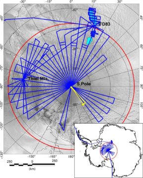
PolarGAP is an ambitious international mission to capture new and critical data about the Earth’s global gravity field.
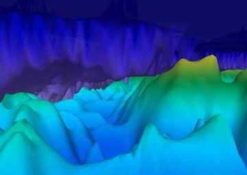
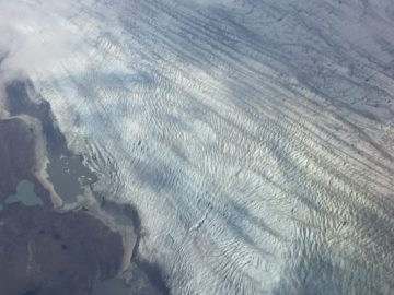
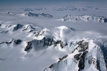
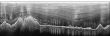
Radio echo A perspective view of the Gamburtsev Subglacial Mountains, imaged using airborne ice-penetrating radar to look through the overlying ice sheet. The rugged subglacial topography holds a record of […]
This project investigated the ice streams of West Antarctica’s Weddell Sea sector through airborne surveys.
AGAP was an international effort to explore the Gamburtsev Subglacial Mountains in the center of East Antarctica.
Wrapping up I have started several of my blog posts saying I am writing in various odd/unusual/uncomfortable locations…the back of a Twin Otter, or in a mountain tent high on […]
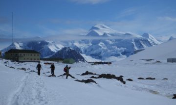
Culture shock Just over two weeks ago I was writing this blog hunched up in a mountain tent, having not washed for a week, and with the company of just […]
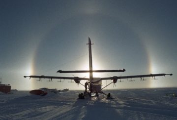
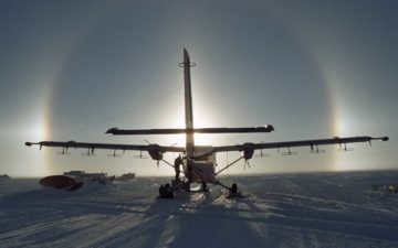
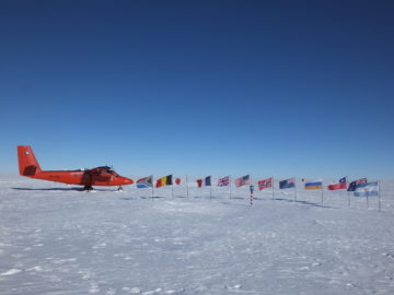
One week on from departing Rothera into the field and the first leg of the PolarGAP survey at FD83 is almost over, I get to sit back, relax a bit […]
The altimeter in the front of the Twin Otter aircraft is showing 8500 ft as we cruise due south from Rothera research station for the next leg in our PolarGAP […]
Tom Jordan is part of the PolarGAP project, an ambitious international collaboration which will use airborne geophysics to explore one of the last known frontiers on our planet – the […]
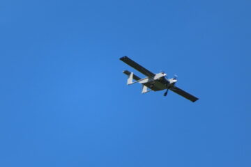
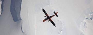
A team testing the Windracers ULTRA drone in Antarctica has shared the first video footage of the aircraft flying autonomously over British Antarctic Survey’s (BAS) Rothera Research Station and its nearby islands.
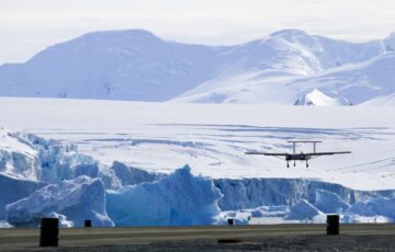
A team have arrived at Rothera Research Station, ready to start testing the new Windracers ULTRA autonomous drone in Antarctica. If successful, the new drone platform could represent a major addition to British Antarctic Survey’s scientific capability on the frozen continent.
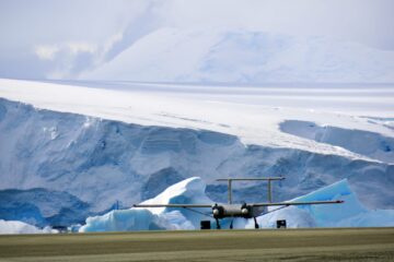
Polar science could reach new heights as researchers prepare to test the new Windracers ULTRA autonomous drone in Antarctica this season.
The ground beneath Antarctica’s most vulnerable glacier has been mapped for the first time, helping scientists to better understand how it is being affected by climate change. Analysis of the […]
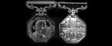
Congratulations to BAS staff who have been awarded a Polar Medal in the 2023 New Year’s Honours List for their scientific work or their technical support for science, in order […]
East Antarctica is the least known region of Earth. Studying this remote part of the continent is extremely difficult, requiring researchers to look beneath kilometres of blanketing ice.
The Innovation Showcase explains how innovative science and technology is helping or, in future, could substantially help the goals of COP26 and of reducing greenhouse gas emissions, enabling adaptation to climate change or informing action related to climate change.
Newly discovered deep seabed channels beneath Thwaites Glacier in West Antarctica may be the pathway for warm ocean water to melt the underside of the ice. Data from two research […]
Scientists have discovered an area near the South Pole where the base of the Antarctic Ice Sheet is melting unexpectedly quickly. Using radar to look through three km of ice, […]
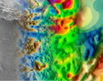
A new ‘heat map’ shows, in unprecedented detail, how geothermal heat is escaping through the Earth’s surface beneath the Greenland Ice Sheet. This is critical information for enabling scientists to […]
Revealing Antarctica’s hidden world
An international team of scientists, led by British Antarctic Survey (BAS), has produced a new map showing how much heat from the Earth’s interior is reaching the base of the […]
Gondwana break-up changed the global continental configuration, leading to the opening of major oceanic gateways, shifts in the climate system and significant impacts on the biosphere, hydrosphere and cryosphere. Although […]
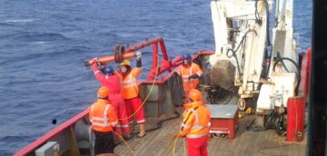
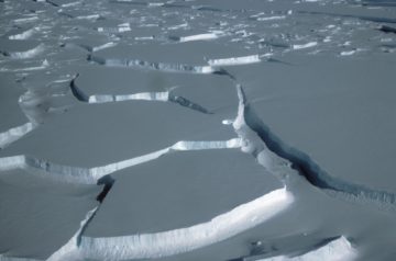
Exploring the seafloor
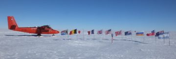
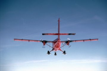
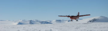
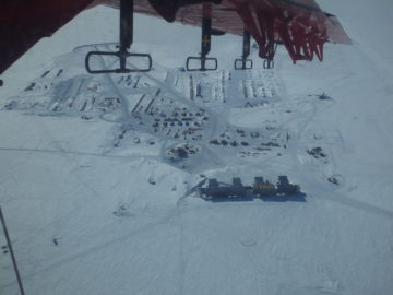
Discover the UK’s national capability to support science from the air

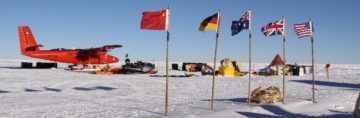
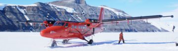
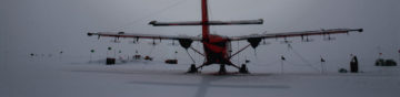
The Twin Otter is a high-wing, twin-engine, turbo-prop aircraft. They are used all over the world and are known for their rugged construction, reliability and short take-off and landing performance.
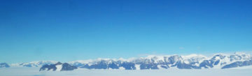
Antarctic “ghost mountains” preserved by ice sheet A new study reveals how the rugged ridgelines of East Antarctica’s ancient and mysterious ‘ghost mountains’ have been preserved for millions of years […]
New studies improve scientists’ understanding of the potential contribution of the Antarctic Ice Sheet to global sea level rise Three peer-reviewed papers in Nature and Nature Geoscience published in recent […]
Ice structures found among hidden Antarctic mountains The discovery of numerous large ice structures within Antarctica’s Dome A region, the site of the buried ‘ghost mountains’, reveals new understanding about […]