
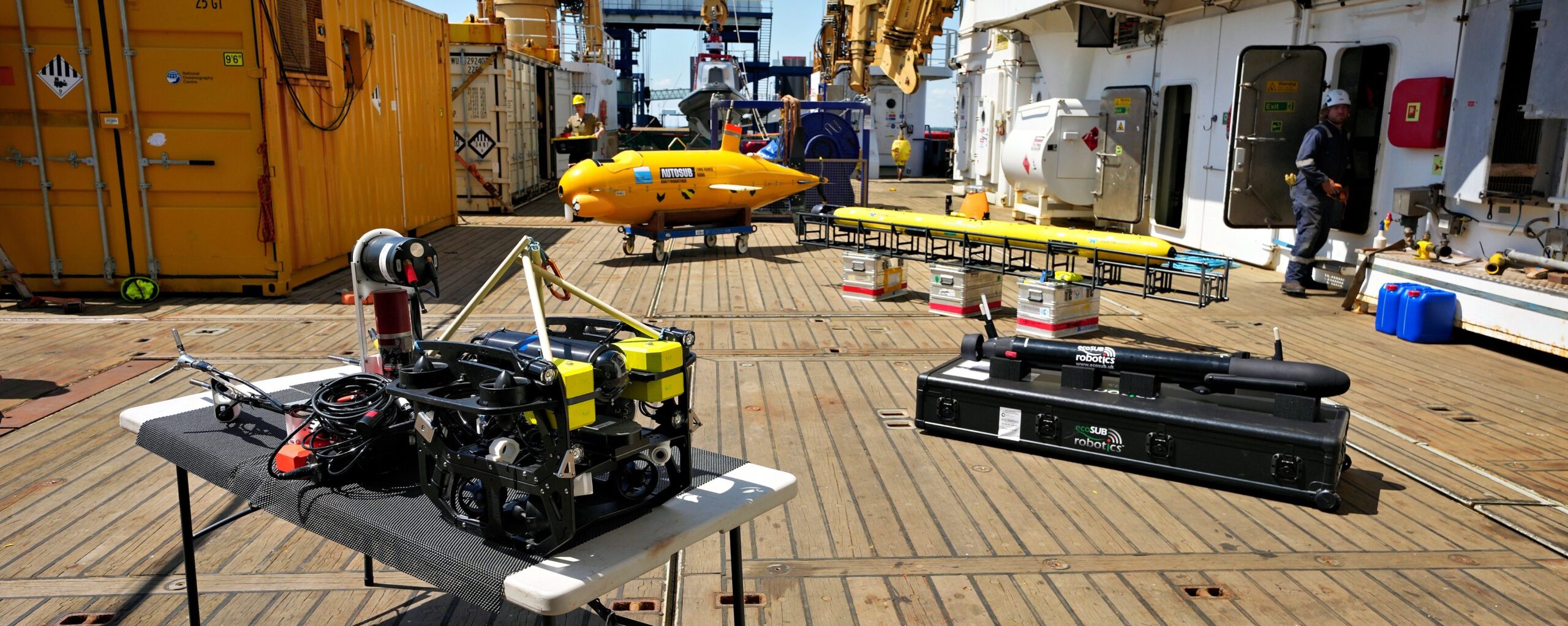
A robot is cruising beneath Antarctic sea-ice. Another is bolted to the face of a collapsing Greenland glacier. A third is silently counting penguins on a remote, windswept beach. None of them has a human operator nearby.
“It’s really cool to be able to whip out my phone here in Cambridge and send commands to a glider that’s doing stuff thousands of miles away in the Antarctic.”
Dr Alex Brearley is an oceanographer at the British Antarctic Survey (BAS). He’s one of the growing number of scientists who’re using autonomous vehicles to investigate Earth’s rapidly changing polar environments.
Underwater, on the surface and in the air – robots of all shapes and sizes are now gathering information on a scale and with a precision that previous generations of researchers could only dream about.
Alex could be there in person in the Antarctic – but doesn’t have to be. Commands are uploaded via the internet and when the robots make the connection, they go about their business.
Alex has several gliders on the go at any one time. They’re equipped with a range of sensors to tell him about the ocean’s properties and how it’s behaving.
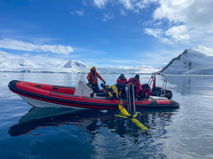
His sleek machines resemble torpedoes and move through the ocean with remarkable efficiency. An oil-filled bladder alters their buoyancy, making them sink and rise, while a moveable battery pack changes the centre of mass to pitch the nose either up or down. A set of small wings then converts that vertical motion into a slow forward glide through the water column. No engine. No propeller. Just physics.
Periodic visits to the surface enable positioning fixes via GPS and an opportunity to beam back data to Cambridge, as well as picking up new commands. Careful power management means you can run a glider for months on end.
Alex currently has a glider fleet patrolling Ryder Bay, just off Rothera Research Station on the Antarctic Peninsula. The gliders are fitted with sensors to monitor how the waters in the bay are being stirred up as glacier ice calves and crashes into the sea. It’s a spectacular process that sends powerful waves sweeping through the water column to mix heat and nutrients, while also pushing carbon down to depth.
This phenomenon of “internal tsunamis”, as they’re called, was first spotted from a crewed ship. The gliders have now taken over the follow-up research as part of the “Polar Ocean Mixing by Internal Tsunamis (POLOMINTS)” project – which makes more sense both economically and scientifically.
“The gliders come in later as the way to observe the same kinds of processes but in much higher resolution,” Alex says. “It’s often about having the longevity of the missions that a ship can’t do without spending vast amounts of money.”
In other words, the ship discovers the signal and the gliders then unpack it.
The big adoption of autonomous vehicles has been driven in large part by a technological convergence, where miniaturised sensors have been integrated into increasingly capable robotic platforms. Many of the same innovations built into our smartphones are also transforming the tools scientists use in the field.
And you don’t need to be a specialist engineer to deploy an autonomous vehicle.
Professor Mark Inall from the Scottish Association for Marine Science (SAMS) was an early adopter of the technologies.
“When I first started with autonomous underwater vehicles (AUVs) it was very, very technical and challenging – you had to spend weeks training just to begin to understand how to run the thing. Now you can pick one up, have a day or two’s training, put it in the water and run it yourself. The barrier to entry has come right down. Yes, it needs to come down a bit further, but we’re already at the stage where non‑specialists can operate these vehicles.”
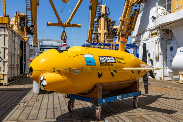
The scope of what’s possible is perhaps best illustrated by what BAS is doing right now in the Arctic. The GIANT (Greenland Ice sheet to AtlaNtic Tipping points) project is in the process of deploying an extraordinary array of vehicles to investigate how exactly Greenland’s fjord glaciers melt when they encounter warm ocean water. Nine different systems are working together on the problem, including the famous chubby yellow submersible known as Boaty McBoatface.
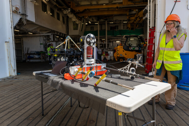
One of the more unusual GIANT vehicles is called Meltstake. It can take measurements in a location no human scientist would dare put themselves – right up against the vertical cliff face of a crumbling glacier. Who wants to risk thousands of tonnes of ice falling on their head?
Meltstake is essentially an automated drilling platform festooned with sensors. It’s delivered to the front of the glacier by a self-driving boat. That’s the easy part. The Meltstake still has to get to the real point of interest… 100m to 200m below the waterline. So, it piggybacks to depth on a remotely operated diving vehicle.
On arrival, the Meltstake then screws itself into the wall, and continues screwing as the ice face melts to keep up with its retreat. Included in the sensor package are cameras, hydrophones to “listen” to the ice, and acoustic scanners to map the ocean currents – the energy that shapes the evolving glacier face.
This persistent, close-up presence of Meltstake against the glacier face allows its operators from Oregon State University to explore a massive gap in climate science, where current computer models appear to underestimate glacier melt – likely because they are not properly representing important details of the melting process.
Oregon colleague Professor Erin Pettit says their previous work on Alaskan fjord glaciers suggests the ice itself is an active participant in its own destruction.
“It’s packed with tiny, pressurised bubbles that hiss and burst as they are released into the water. When the bubbles pop out, they disturb the boundary layer of the fluid,” Erin explains. “This creates a chaotic churn that generates more of that energy that then feeds back to melt the ice even faster.”
No human scientist could have got that close. That’s rather the point.
While some robots can be bolted directly into the path of potential destruction, others are designed to solve a different problem entirely: simply being in the right place at the right time.
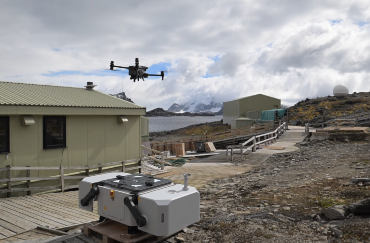
For Dr Norman Ratcliffe, a seabird biologist at BAS, this means deploying a remote “drone in a box” system on Signy Island, part of the South Orkney archipelago.
The territory hosts a summer-only research station. That is, scientists are present only in the southern summer, which means they miss the chance to observe the early breeding activity of Adélie penguins. But Norman’s drone is on station to catch the birds’ entire reproductive cycle.
The drone lives in a powered docking hangar. This both charges the robot and protects it from the foulest weather. Aerial surveys to count bird nests and assess the population are commanded from Cambridge HQ, again via the internet.
The pre-programmed reconnaissance flights are impressive to watch. The drone will fly up a hill, following the contours perfectly to produce a map in which the ground sampling distance is exactly the same throughout the entire survey.
“If we can pilot things safely from Cambridge, that allows us to do surveys almost any time of year, irrespective of the staffing we have on station,” Norman says. “In terms of doing repetitive survey tasks, it’s just an incredibly efficient way to do it, particularly if you’re short of people or trained pilots.”
The trials last summer were a huge success, and the aspiration is to have the drone in place year-round. Norman would also like to use long-distance drones to extend surveys to the west of the archipelago. It’s where large colonies of penguins haven’t been observed in detail for decades. Drone work could help address questions about how breeding success is being affected by the fishing industry’s nearby pursuit of krill, the tiny crustaceans that form a key food source for the birds.
Norman would no doubt find an ally in BAS biological oceanographer Dr Sophie Fielding. She’s been observing krill in waters off the island of South Georgia, using a 2m-long autonomous surface vessel called Sailbuoy.
Think “miniature yacht” and you’ll get the look of the vehicle immediately – a sail, hull, and keel. The only driven element is the rudder, which shifts position to guide the vessel as it tacks across the wind. Power for the onboard electronics comes from deck-mounted solar panels feeding a couple of laptop-style lithium batteries.
Sophie’s Sailbuoy is equipped with an echosounder to detect the presence and abundance of krill to a depth of 300m to 400m. The data comes back via satellite.
One of the big attractions of Sailbuoy is its ability to stay out at sea gathering data for months on end – beyond the time available to a large, in-demand research ship. And, importantly for BAS, which is committed to reducing its environmental footprint – Sailbuoy is a an exceptionally low-carbon way of collecting data.
“For low-complexity platforms like Sailbuoy you’d probably want to deploy swarms of them – swarms of Sailbuoys chasing swarms of krill,” Sophie says.
Fixed-wing aerial drones are also becoming a staple of polar research, and the eBee X is one such vehicle that’s making a great contribution.
About 1.2m wingtip to wingtip, the black, propeller-driven drone weighs just 1.6kg – light enough for our scientists to carry it into the field in a backpack.
It’s made largely from polystyrene with a carbon-fibre base plate to protect the battery, electronics and sensor system.
And eBee X is super-easy to use. It’s hand-launched, fully autonomous and will stay aloft for about 90 minutes. Recovery is a simple, soft “crash” landing.
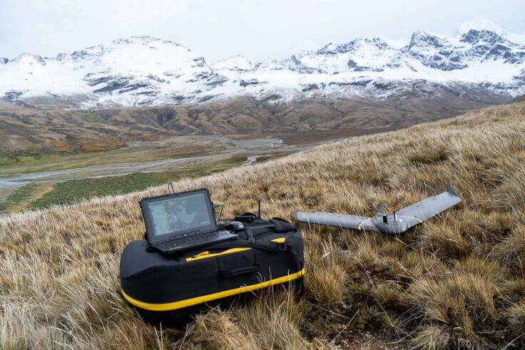
The vehicle has proved hugely valuable in the globally renowned wildlife haven of South Georgia, where the authorities running the British Overseas Territory understand its reliability and are comfortable with it being flown beyond the line of sight of our researchers. That approval has enabled eBee X to make long, sweeping photographic sorties along beaches, updating the status of animal populations, some of which due to their remote location have rarely been visited and are poorly understood.
Nathan Fenney heads geomatics and led the introduction of the eBee X at BAS.
“Traditionally small drone operations have typically been conducted within what’s called ‘visual line of sight’ (VLOS), which requires the drone to stay within around 500 m of the pilot during the flight. By being able to operate ‘beyond visual line of sight’ (BVLOS) with platforms like the eBee X, we are able to survey significantly larger areas, potentially over several kilometres, and survey targets not otherwise accessible overland, leaving us best placed to capture both South Georgia’s largest and more remote wildlife colonies.”
Using the data collected by the eBee X, the team has developed a new counting methodology which uses the digital elevation model (3D model of the surface), produced using photogrammetry to count the animals, rather than the imagery . This underpinned the first full, direct tally of king penguins at one of the birds’ hotspots at St Andrews Bay, confirming a massive increase in breeding pairs, now numbering more than 132,000. Ironically, the increase is probably the result of rapid glacier retreat making more space on the beaches for the penguins to nest.
eBee X surveys also revealed a sharp, post-bird-flu collapse in southern elephant seals at three key South Georgia colonies. It was estimated that island-wide, over 50,000 females could have failed to arrive for the annual breeding season.
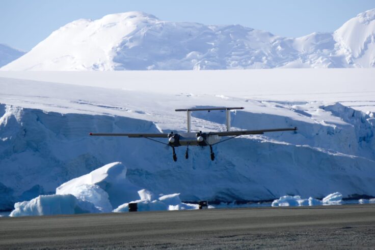
When it comes to fixed-wing drones, the Windracer ULTRA is in a different league. It’s 10m wingtip to wingtip and can easily carry 50-60kg of payload. It will fly on its own, beyond the horizon, for up to 1,000km.
For geologist Dr Tom Jordan, it means his investigations into the deep rock structures under Antarctica’s ice sheet are entering a new era.
In the past, his survey work required the heft of a crewed Twin Otter plane – a long-time workhorse in the polar south. Picture Tom sitting in the back of one of these planes, monitoring his instruments – radars, magnetometers, gravimeters, and the like. Now, he can stay on the ground, while the Windracer completes the flight plan autonomously.
“For years the instruments were too heavy and the drones too small. Now the lines have crossed – the sensors are light enough and the drones are capable enough that using them for serious Antarctic science finally makes sense,” Tom explains. “By moving our surveys on to drones, we can do the same science with a fraction of the fuel and logistics. Instead of needing 200 drums of fuel for a big aircraft, we might get away with 20 for a Windracer. Using a drone for survey also frees up our Twin Otter aircraft for other critical work supporting field teams, or surveying with larger sensors, making the best use of all our assets.”
Tom used Windracer recently to gather new insights into the geological history of the Antarctic Peninsula. This “finger” of land that stretches north from the white continent towards South America was formed by a string of volcanoes whose underlying pools of magma turned to solid rock. Windracer was able to map the massive “roots” of two of those ancient volcanoes that formed up to 50 million years ago.
Yet, even as all of this activity grows, the consensus among BAS scientists is that autonomous vehicles are a supplement to human presence. They’re not a replacement.
For one thing, regulations are still trying to catch up with the reality of all the uncrewed traffic. Tom Jordan will tell you about the pain of getting permits to fly large drones in what seem to be the emptiest spaces on Earth. It can be a time-consuming interaction with authorities that aren’t yet resourced to deal with all the requests they receive.
Likewise, Sophie Fielding can describe her back-and-forth with marine agencies who – understandably – want reassurance that her mini science yacht won’t collide with a ship and damage its propeller.
But the tide is coming in, and fast.
BAS Director of Science, Professor Petra Heil, frames autonomous platforms as the missing middle layer in polar science – the nimble go-betweens that fill the gap between satellites staring down from space and the scientists braced on the decks of big ships or standing on the ice.
And she’s clear that artificial intelligence will be riding the wave, orchestrating this tiered approach to observing:
“AI can show us where our science is blind. It can pull together satellites, models and past measurements to highlight the hotspots of uncertainty. You need AI to manage the data, to target where you send the platforms, and to keep reshaping the missions as the environment and the technology change.”
But perhaps Norman Ratcliffe puts it best. For all the technological wizardry, there are still some things that only a human scientist with muddy knees can do:
“There’s no drone I know of that can catch, weigh and put a tag on a penguin; or collect their poo to look at what they’ve been eating.”