Polar Scientific Innovation Lead

Logist develops decision support tools that use environmental data to help experts make the best routing and planning decisions. It brings together specialists in research software engineering, AI methods, sea ice forecasting and mapping to create tool sets ready to be used by crew on the on the RRS Sir David Attenborough and operations planners across British Antarctic Survey (BAS) and the Natural Environment Research Council (NERC). These tools could also be beneficial if used by other polar operators so, with support from the Government Office for Technology Transport, we are exploring how these tools could have the maximum societal and economic benefit.
These tools create suggested routes and itineraries for ships and autonomous vehicles (such as Boaty McBoatface) that satisfy or optimise a range of conditions that a planner might want to specify – from obvious ones like avoiding getting stuck in sea ice to minimising carbon emissions and causing the least ecological impact in sensitive areas. Planners and crew then use their extensive experience of polar operations to choose the routes or itineraries that work the best for them in the real world.
They also let planning experts try out ‘what if’ scenarios like ‘what if we used a fleet of autonomous vehicles instead of one large ship to do all these tasks?’ or ‘what if these autonomous vehicles had 10% more battery?’ This helps us to make the most effective decisions about what we do in the present and how we should operate in the future.
Logist tools provide crew and planners with a choice of routes and plans that save time, money and carbon emissions. This means that we can make as efficient use of our ships and vessels as possible – doing the most science with the least environmental harm. They also make us safer and more resilient. Polar conditions are very unpredictable so, by providing possible routes much more quickly than a person alone can, we can replan immediately if something changes. You can read more about why we need these tools in our Impact section.
These tools don’t exist from commercial providers because they’re specific to the polar regions and the conditions we operate in – the weather, the wind, the waves, the sea ice and so on. By developing them ourselves, we bring together the deep environmental understanding we get from the science we do every day with the polar operational expertise we’ve gained over more than 80 years as the UK’s presence in Antarctica. We use our environmental expertise – both from our science and from our experience as an operator – for environmental stewardship.
But that doesn’t mean that we’re the only people who would benefit from these tools. With the help of the Government Office for Technology Transfer and Innovate UK, we have been exploring commercialising these tools to have a real societal impact.
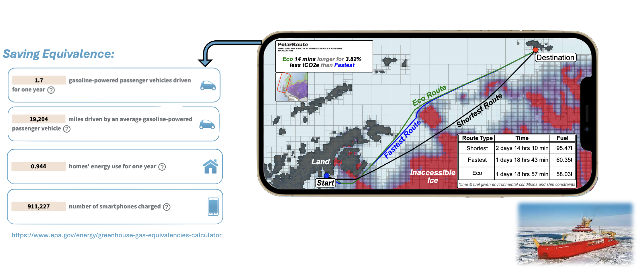
PolarRoute is our route planning tool – it finds the fastest, the most carbon efficient or the least ecologically impactful route from A to B, or some trade-off of all three. It uses huge quantities of data from satellite and in-situ observations, as well as forecasts and models, to create a detailed digital model of the environment. Using this and information about the vessel itself, PolarRoute generates a set of possible routes that satisfy constraints set by a user. These routes are visible to the user through the Sea Ice Information Service on board the RRS Sir David Attenborough. We are currently working on other ways to access PolarRoute to make it as easy as possible for users.
VOLT generates plans for fleets of ships and autonomous vessels. It takes lists of destinations, waypoints and tasks, vehicle characteristics and routes generated by PolarRoute to create efficient itineraries that specify the movements of potentially hundreds of vessels across hundreds of tasks. Because these itineraries can be created so fast, VOLT could also act as a simulator and longer-term planning tool. For example, it could consider the costs and benefits of using a fleet of autonomous battery powered vehicles versus one larger vessel to complete the same tasks.
British Antarctic Survey develops a range of tools and methods that increase our understanding of the polar environment, including sea ice. This includes machine learning tools to improve sea ice mapping and forecasting. These are the result of curiosity-driven research but have the potential to improve the accuracy of Logist tools.
Whilst routes and ship itineraries can be made by human planners, itineraries that coordinate fleets of autonomous vehicles are much more complex. You might have 100 tasks to do in 100 different locations, and each task can be done by some autonomous vehicles but not others. Each autonomous vehicle must be dropped off and then picked up and can only go a certain distance before its battery runs out. How do you work out which tasks to do in which order using which vehicles at what times?
This is impossible for human planners to do manually so we can’t operate fleets of autonomous vehicles without decision support tools. And doing science with fleets of battery powered vehicles can be much more safe, efficient and environmentally friendly than doing it with crewed vessels. These tools unlock the marine science of the future.
When navigating in the polar regions, the most direct routes are not always the most efficient as the shortest route might involve going through more ice. Breaking through ice takes a lot of time and uses a lot of fuel, so a lot of carbon dioxide is emitted. Our models predict that typical routes generated with Logist tools could save 4% carbon emissions compared to the fastest route and itineraries can save up to 13% using current marine infrastructure. We’re developing the right methodology to test these savings in real life on our ship. Even modest percentages mean big savings, though. Operating the RRS Sir David Attenborough emits more than 10,000 tonnes of CO2 equivalent per year – so we could make carbon savings in one journey equivalent to an entire household’s energy use for a year.
Coming up with a route or itinerary manually can take weeks or months. Logist itinerary planning tools can take more possibilities than atoms in the universe and return a short list of good options within seconds.
Polar operations are unpredictable – weather changes, people need to be evacuated, vessels are lost and new data is discovered. In all these situations, plans need to change. Logist tools allow quick replanning that minimises losses when things don’t go as planned.
Planners don’t just plan the next year. We also need to think about the long-term future. That includes deciding what type of vessels we might have, the design of ships, the number of vessels and the battery capacity of our autonomous vehicles, for example. Because Logist tools take into account vessel characteristics, they allow planners to run ‘what if’ scenarios about potential changes to what vessels they operate. This allows operators to make evidence-based decisions for their more distant future.
Polar Scientific Innovation Lead

AI Team Lead

AI Researcher in Optimisation and Planning

Research Software Engineering Lead

Senior Research Software Engineer

Innovation Community Officer

Machine Learning Research Scientist

Computing - Software Engineer

Administrator
Fontend Developer/Geospatail

Head of MAGIC

Senior Research Software Engineer
Reaching net zero, as a country or a business, requires new measures, technology and innovations. Digital twins are an example of this; they can be a powerful tool to drive innovation and efficiency.