Polarimetric Radar

The radar system is composed of a complex waveform generator, signal processor, data handler and data store. It includes a high power transmitter (up to 66dBm or 4kW), a low noise receiver and frequency domain digital processing of the received signal. The carrier frequency is 150MHz and the bandwidth is 10MHz limited mainly by the folded dipole aerials. Along-track resolution is governed by the sample period, pre and post-processed signal stacking and aircraft speed.

The sample period is 64uS, and the hardware stacking typically 25 giving a pre-processed along-track resolution of ~10cm.  Data is stored on dual-redundant removable media. For the figures given above a 4.5h flight will generate around 150GB of data.

Echogram

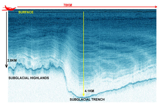
Post-processed resolution is usually set to about 1m.  Depth resolution is governed by pulse type, period and bandwidth. With this system it is typically 8m. Positional accuracy using differential GPS gives cm accuracy.In polarimetric mode pulses are transmitted alternately from orthogonally orientated aerials and returning coherent signal phase and amplitude is received and recorded via similarly oriented aerials. The sample rate does not change between modes, the along-track resolution is halved but the received signal data rate is doubled, therefore the overall volume of data captured on a typical flight remains the same.

In polarimetric mode pulses are transmitted alternately from orthogonally orientated aerials and returning coherent signal phase and amplitude is received and recorded via similarly oriented aerials. The sample rate does not change between modes, the along-track resolution is halved but the received signal data rate is doubled, therefore the overall volume of data captured on a typical flight remains the same.

Understanding the effects of global warming on the melting and thickness of vast ice sheets is important for future sea level rises to be accurately predicted.  To monitor these ice sheets, often up to 4km thick, an airborne Polarimetric Radar system was developed. Understanding how ice behaves at the interface between ice and bedrock is useful in understanding how global warming will affect large ice sheets.

The radar provides a unique and never before seen view of the internal structure of an ice sheet. Using phase and frequency sensitive radar enables these instruments to be carried on aeroplanes and therefore it is much easier to cover remote and difficult terrain.

The Equipment

  • The different frequencies and phases allow a clear picture of the different layers of ice and of the ice/bedrock interface. The detail is extraordinary and gives an exceptional insight in to the composition and make-up of large ice bodies. The instrument has been used on the Filchner-Ronne ice sheet and it has been observed that the bottom of the ice sheet has been melting by one metre a year. At the moment, this ice loss is being replenished by ice further back.
  • A 4.5-hour flight will typically generate 150GB of data that will be analysed by BAS scientists. The accuracy of the data is remarkable; the horizontal accuracy can be as low as 10cm & the vertical accuracy could be as fine as 8m.

AGAP

Exploring Antarctica's 'ghost mountains'


BBAS

The BBAS science programme was a British Antarctic Survey-funded project, part of the wider BBAS-AGASEA collaboration between BAS, the University of Texas Institute for Geophysics (UTIG), and the U.S. National …


Bedmap

Bedmap is a collaborative community project with the aim to produce a new map and datasets of Antarctic ice thickness and bed topography for the international glaciology and geophysical community, …


Bedmap3

Bedmap3 is a collaborative community project with the aim to produce a new map and datasets of Antarctic ice thickness and bed topography for the international glaciology and geophysical community, …


Filchner Ice Shelf System, Antarctica

Understanding the contribution that polar ice sheets make to global sea-level rise is recognised internationally as urgent.  The mission of this five-year project is to capture new observations and data …


GRADES-IMAGE

The GRADES-IMAGE science programme was a British Antarctic Survey-funded project over the Antarctic Peninsula and Filchner-Ronne Ice Shelf. The aim of the programme was to image englacial layering and bedrock …


ICEGRAV

The ICEGRAV project is a major international collaboration between Danish, US, UK, Norwegian and Argentinian scientists. The primary aim of the project is to carry our airborne gravity observations across …


PolarGAP

The polar regions have the capacity to amaze and astound, but despite the considerable progress of recent decades we still know far less about them than less remote parts of …


WISE-ISODYN

The WISE-ISODYN (WISE: WIlkes Basin/Transantarctic Mountains System Exploration; ISODYN: Icehouse Earth: Stability Or DYNamism?) science programme was joint UK-Italian project between the British Antarctic Survey and the Italian Programma Nazionale …