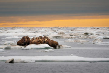
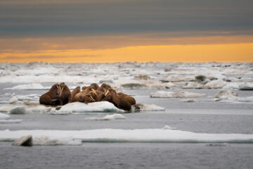
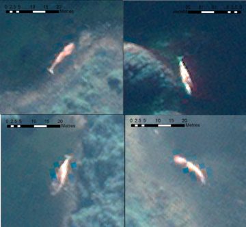
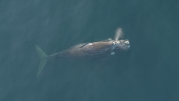
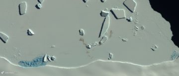
Counting Walruses from Space
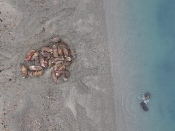
Despite their importance to Arctic ecosystems, we don’t know how many walruses exist. We’re using satellite images and citizen science to count walruses.
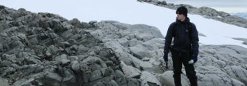
Dr Peter Fretwell is a senior geographic and remote sensing scientist in the Mapping and Geographic Information Centre (MAGIC) at BAS. He leads the Wildlife From Space group and has over the past decade published a number of ground-breaking remote sensing and GIS studies that have increase our understanding of a range of Polar environments.
He has worked at BAS since January 2002 and spent the first seven year of that career in a mainly cartographic role. That changed in 2009, when by chance he discovered that he could detect emperor penguins using satellite imagery. A number of high-profile science papers followed which changed his role to focus primarily on remote sensing and GIS. Two primary strands of research include the Bedmap project and the detection, counting and understanding polar predators from satellite imagery, from which he has published a number of ground breaking, influential and novel studies. This focus led to the creation of the Wildlife From Space Group in 2022, which Peter managers, which now has multiple ERCS and funded projects looking at a range of wildlife including emperor penguin, seals, walrus whales and flying seabirds.
In 2023 he received a prestigious Erskine Fellowship and is currently the chair of the SCAR Bedmap3 Action Group and the SOOS Censusing Animal Populations from Space (CAPS) group. He has published over a hundred papers and currently (2025) has a H index of 40.
He has also sat on a number of international steering committees and is a Fellow of the Royal Geographical Society.
My work currently involves geospatial analysis and applied remote sensing across a range of environmental fields. Recent emphasis has been on the use of very high resolution satellite imagery to count and study wildlife, and the construction of digital elevation models such as the Bedmap3 project which mapped the bed topography of Antarctica. Additionally my roll includes supporting BAS science and logistics with mapping and geospatial analysis and managing the BAS Wildlife from Space group.
see https://scholar.google.com/citations?user=5qOogLUAAAAJ&hl=en&oi=ao
Clarke, Penny J. ORCID record for Clarke, Penny J.. Cubaynes, Hannah C. ORCID record for Cubaynes, Hannah C.. Stockin, Karen A. Bowler, Ellen ORCID record for Bowler, Ellen. Carlyon, Kris. Attard, Marie R.G. ORCID record for Attard, Marie R.G.. Fretwell, Peter T. ORCID record for Fretwell, Peter T.. Skachkova, Aliaksandra. de Vos, Asha. McConnell, Kaitlin M. Medina-Lopez, Encami. Dubon, Sergio Lopez. Jackson, Jennifer A. ORCID record for Jackson, Jennifer A.. (2026) Open-source satellite image pre-processing and annotation workflows: Stranded whale and dolphin case study.
Cubaynes, Hannah C. ORCID record for Cubaynes, Hannah C.. Matthews, Cory J.D. Garde, Eva. Gavrillo, Maria. Heide-Jørgensen, Mads Peter. Higdon, Jeff W. Kovacs, Kit M. Leskova, Margarita. Lydersen, Christian. Solovyev, Boris. Vergara-Pena, Alejandra. Fretwell, Peter T. ORCID record for Fretwell, Peter T.. (2026) A distribution-wide dataset of Atlantic walrus terrestrial haul-out sites.
McGinnity, Claire. Bamford, Connor C.G. ORCID record for Bamford, Connor C.G.. Fenney, Nathan ORCID record for Fenney, Nathan. Fleming, Andrew ORCID record for Fleming, Andrew. Forcada, Jaume ORCID record for Forcada, Jaume. Tift, Michael S. Hückstädt, Luis A. Costa, Daniel P. Fretwell, Peter T. ORCID record for Fretwell, Peter T.. (2026) Semi‐automated seal detection on the Western Antarctic Peninsula: an unsupervised machine learning approach for detecting ice seals in aerial survey data.
Fretwell, P.T. ORCID record for Fretwell, P.T.. (2026) Discovery of Antarctic moulting sites in satellite imagery reveals new threat to emperor penguins.
Cubaynes, Hannah C. ORCID record for Cubaynes, Hannah C.. Vergara-Pena, Alejandra. Bowler, Ellen ORCID record for Bowler, Ellen. Downie, Rod. Forcada, Jaume ORCID record for Forcada, Jaume. Garde, Eva. Heide-Jørgensen, Mads Peter. Higdon, Jeff W. Ida, Emina. Kovacs, Kit M. Lancaster, Melanie L. Lapointe St Pierre, Mathilde. Lydersen, Christian. Matthews, Cory J.D. Spencer, Matt. Fretwell, Peter T. ORCID record for Fretwell, Peter T.. (2026) A roadmap towards monitoring walruses from space.
Macdonald, Grant J. ORCID record for Macdonald, Grant J.. Jamieson, Stewart S.R. Stokes, Chris R. Marochov, Melanie. Fretwell, Peter T. ORCID record for Fretwell, Peter T.. Jenouvrier, Stéphanie. (2026) Response of emperor penguins to 40 years of changing ice conditions at the Astrid, Mertz and SANAE colonies using satellite remote sensing (1984–2024).
Bamford, Connor C.G. ORCID record for Bamford, Connor C.G.. Fenney, Nathan ORCID record for Fenney, Nathan. Coleman, Jamie ORCID record for Coleman, Jamie. Fox-Clarke, Cameron. Dickens, John. Fedak, Mike ORCID record for Fedak, Mike. Fretwell, Peter ORCID record for Fretwell, Peter. Hückstädt, Luis ORCID record for Hückstädt, Luis. Hollyman, Phil ORCID record for Hollyman, Phil. (2025) Highly Pathogenic Avian Influenza Viruses (HPAIV) Associated with Major Southern Elephant Seal Decline at South Georgia.
Clarke, Penny J. ORCID record for Clarke, Penny J.. Cubaynes, Hannah C. ORCID record for Cubaynes, Hannah C.. Jackson, Jennifer A. ORCID record for Jackson, Jennifer A.. Taylor, Nicola L. Johnston, David W. de Vos, Asha. Fretwell, Peter T. ORCID record for Fretwell, Peter T.. Skachkova, Aliaksandra. Jones, Gwawr. (2025) Talking About the Weather: The Feasibility of Using Very High-Resolution Optical Satellite Imagery to Monitor Live and Stranded Cetaceans Around the UK and UK Overseas Territories.
Gray, Andrew Møller. Thomson, Alex Innes. Colesie, Claudia. Convey, Peter ORCID record for Convey, Peter. Fretwell, Peter ORCID record for Fretwell, Peter. Smith, Alison G. Peck, Lloyd ORCID record for Peck, Lloyd. Davey, Matthew P. (2025) Modelling snow algal habitat suitability and ecology under extreme weather events on the Antarctic Peninsula.
Holmes, C. ORCID record for Holmes, C.. Doddridge, E. Fretwell, P. ORCID record for Fretwell, P.. (2025) Antarctic sea ice #4: record lows between 2022 and 2025.
Fretwell, Peter ORCID record for Fretwell, Peter. (2025) BEDMAP3: Bed topography of Antarctica.
Fretwell, P.T. ORCID record for Fretwell, P.T.. Bamford, C. ORCID record for Bamford, C.. Skachkova, A. Trathan, P.N. ORCID record for Trathan, P.N.. Forcada, J. ORCID record for Forcada, J.. (2025) Regional emperor penguin population declines exceed modelled projections.
Attard, Marie R.G. ORCID record for Attard, Marie R.G.. Phillips, Richard A. ORCID record for Phillips, Richard A.. Oppel, Steffen. Bowler, Ellen ORCID record for Bowler, Ellen. Fretwell, Peter T. ORCID record for Fretwell, Peter T.. (2025) Feasibility of using very high-resolution satellite imagery to monitor Tristan albatrosses Diomedea dabbenena on Gough Island.
Innes Thomson, Alex. Gray, Andrew. Colesie, Claudia. Thomas, Naomi. Moulton, Hannah. Convey, Peter ORCID record for Convey, Peter. Smith, Alison G. Fretwell, Peter ORCID record for Fretwell, Peter. Peck, Lloyd ORCID record for Peck, Lloyd. Davey, Matthew P. (2025) Surface darkening by abundant and diverse algae on an Antarctic ice cap.
Pritchard, Hamish D. ORCID record for Pritchard, Hamish D.. Fretwell, Peter T. ORCID record for Fretwell, Peter T.. Fremand, Alice C. ORCID record for Fremand, Alice C.. Bodart, Julien A. ORCID record for Bodart, Julien A.. Kirkham, James D. ORCID record for Kirkham, James D.. Aitken, Alan. Bamber, Jonathan. Bell, Robin. Bianchi, Cesidio. Bingham, Robert G. ORCID record for Bingham, Robert G.. Blankenship, Donald D. Casassa, Gino. Christianson, Knut. Conway, Howard. Corr, Hugh F.J. Cui, Xiangbin. Damaske, Detlef. Damm, Volkmar. Dorschel, Boris ORCID record for Dorschel, Boris. Drews, Reinhard ORCID record for Drews, Reinhard. Eagles, Graeme. Eisen, Olaf ORCID record for Eisen, Olaf. Eisermann, Hannes. Ferraccioli, Fausto ORCID record for Ferraccioli, Fausto. Field, Elena ORCID record for Field, Elena. Forsberg, René. Franke, Steven ORCID record for Franke, Steven. Goel, Vikram ORCID record for Goel, Vikram. Gogineni, Siva Prasad. Greenbaum, Jamin ORCID record for Greenbaum, Jamin. Hills, Benjamin. Hindmarsh, Richard C.A. ORCID record for Hindmarsh, Richard C.A.. Hoffman, Andrew O. Holschuh, Nicholas. Holt, John W. Humbert, Angelika ORCID record for Humbert, Angelika. Jacobel, Robert W. Jansen, Daniela. Jenkins, Adrian. Jokat, Wilfried. Jong, Lenneke ORCID record for Jong, Lenneke. Jordan, Tom A. ORCID record for Jordan, Tom A.. King, Edward C. ORCID record for King, Edward C.. Kohler, Jack. Krabill, William. Maton, Joséphine. Gillespie, Mette Kusk. Langley, Kirsty. Lee, Joohan ORCID record for Lee, Joohan. Leitchenkov, German. Leuschen, Cartlon. Luyendyk, Bruce ORCID record for Luyendyk, Bruce. MacGregor, Joseph A. ORCID record for MacGregor, Joseph A.. MacKie, Emma. Moholdt, Geir. Matsuoka, Kenichi ORCID record for Matsuoka, Kenichi. Morlighem, Mathieu ORCID record for Morlighem, Mathieu. Mouginot, Jérémie ORCID record for Mouginot, Jérémie. Nitsche, Frank O. ORCID record for Nitsche, Frank O.. Nost, Ole A. Paden, John ORCID record for Paden, John. Pattyn, Frank. Popov, Sergey. Rignot, Eric ORCID record for Rignot, Eric. Rippin, David M. ORCID record for Rippin, David M.. Rivera, Andrés ORCID record for Rivera, Andrés. Roberts, Jason L. ORCID record for Roberts, Jason L.. Ross, Neil ORCID record for Ross, Neil. Ruppel, Antonia. Schroeder, Dustin M. Siegert, Martin J. ORCID record for Siegert, Martin J.. Smith, Andrew ORCID record for Smith, Andrew. Steinhage, Daniel. Studinger, Michael ORCID record for Studinger, Michael. Sun, Bo. Tabacco, Ignazio. Tinto, Kirsty J. ORCID record for Tinto, Kirsty J.. Urbini, Stefano. Vaughan, David G. ORCID record for Vaughan, David G.. Wilson, Douglas S. Young, Duncan A. Zirizzotti, Achille. (2025) Bedmap3 updated ice bed, surface and thickness gridded datasets for Antarctica.
Francis, Josie. Wakefield, Ewan. Jamieson, Stewart S.R. Phillips, Richard A. ORCID record for Phillips, Richard A.. Hodgson, Dominic A. ORCID record for Hodgson, Dominic A.. Southwell, Colin. Emmerson, Louise. Fretwell, Peter ORCID record for Fretwell, Peter. Bentley, Michael J. McClymont, Erin L. (2024) A circumpolar review of the breeding distribution and habitat use of the snow petrel (Pagodroma nivea), the world’s most southerly breeding vertebrate.
Roland, Thomas P. Bartlett, Oliver T. Charman, Dan J. Anderson, Karen. Hodgson, Dominic A. ORCID record for Hodgson, Dominic A.. Amesbury, Matthew J. Maclean, Ilya. Fretwell, Peter T. ORCID record for Fretwell, Peter T.. Fleming, Andrew ORCID record for Fleming, Andrew. (2024) Sustained greening of the Antarctic Peninsula observed from satellites.
Walshaw, Charlotte V. Gray, Andrew. Fretwell, Peter T. ORCID record for Fretwell, Peter T.. Convey, Peter ORCID record for Convey, Peter. Davey, Matthew P. Johnson, Joanne S. ORCID record for Johnson, Joanne S.. Colesie, Claudia. (2024) A satellite-derived baseline of photosynthetic life across Antarctica.
Cubaynes, Hannah C. ORCID record for Cubaynes, Hannah C.. Forcada, Jaume ORCID record for Forcada, Jaume. Kovacs, Kit M. Lydersen, Christian. Downie, Rod. Fretwell, Peter T. ORCID record for Fretwell, Peter T.. (2024) Walruses from space: walrus counts in simultaneous remotely piloted aircraft system versus very high-resolution satellite imagery.
Fretwell, Peter ORCID record for Fretwell, Peter. (2024) A 6 year assessment of low sea-ice impacts on emperor penguins [Short Note].
LaRue, M. Iles, D. Labrousse, S. Fretwell, P. ORCID record for Fretwell, P.. Ortega, D. Devane, E. Horstmann, I. Viollat, L. Foster-Dyer, R. Le Bohec, C. Zitterbart, D. Houstin, A. Richter, S. Winterl, A. Wienecke, B. Salas, L. Nixon, M. Barbraud, C. Kooyman, G. Ponganis, P. Ainley, D. Trathan, P. ORCID record for Trathan, P.. Jenouvrier, S. (2024) Advances in remote sensing of emperor penguins: first multi-year time series documenting trends in the global population.
Attard, Marie R.G. ORCID record for Attard, Marie R.G.. Phillips, Richard A. ORCID record for Phillips, Richard A.. Bowler, Ellen ORCID record for Bowler, Ellen. Clarke, Penny J. ORCID record for Clarke, Penny J.. Cubaynes, Hannah ORCID record for Cubaynes, Hannah. Johnston, David W. Fretwell, Peter T. ORCID record for Fretwell, Peter T.. (2024) Review of Satellite Remote Sensing and Unoccupied Aircraft Systems for Counting Wildlife on Land.
Jawak, Shridhar D. Wankhede, Sagar F. Luis, Alvarinho J. Pandit, Prashant H. Convey, Peter ORCID record for Convey, Peter. Fretwell, Peter T. ORCID record for Fretwell, Peter T.. Schulz, Karsten. Nikolakopoulos, Konstantinos G. Michel, Ulrich. (2024) How precisely can we map blue ice in Antarctica?.
Fretwell, Peter ORCID record for Fretwell, Peter. (2024) Four unreported emperor penguin colonies discovered by satellite.
Fretwell, Peter T. ORCID record for Fretwell, Peter T.. Boutet, Aude. Ratcliffe, Norman ORCID record for Ratcliffe, Norman. (2023) Record low 2022 Antarctic sea ice led to catastrophic breeding failure of emperor penguins.
Green, Katherine M. ORCID record for Green, Katherine M.. Virdee, Mala K. Cubaynes, Hannah C. ORCID record for Cubaynes, Hannah C.. Aviles-Rivero, Angelica I. Fretwell, Peter T. ORCID record for Fretwell, Peter T.. Gray, Patrick C. Johnston, David W. Schönlieb, Carola-Bibiane. Torres, Leigh G. Jackson, Jennifer A. ORCID record for Jackson, Jennifer A.. (2023) Gray whale detection in satellite imagery using deep learning.
Fretwell, Peter T. ORCID record for Fretwell, Peter T.. Cubaynes, Hannah C. ORCID record for Cubaynes, Hannah C.. Shpak, Olga. (2023) Satellite image survey of beluga whales in the southern Kara Sea.
Jawak, Shridhar D. Luis, Alvarinho J. Pandit, Prashant H. Wankhede, Sagar F. Convey, Peter ORCID record for Convey, Peter. Fretwell, Peter T. ORCID record for Fretwell, Peter T.. (2023) Exploratory mapping of blue ice regions in Antarctica using very high resolution satellite remote sensing data.
Cubaynes, Hannah Charlotte ORCID record for Cubaynes, Hannah Charlotte. Clarke, Penny Joanna ORCID record for Clarke, Penny Joanna. Goetz, Kimberly Thea. Tyler, Aldrich. Fretwell, Peter Thomas ORCID record for Fretwell, Peter Thomas. Leonard, Kathleen Elise. Khan, Christin Brangwynne. (2023) Annotating very high-resolution satellite imagery: A whale case study.
Frémand, Alice C. ORCID record for Frémand, Alice C.. Fretwell, Peter ORCID record for Fretwell, Peter. Bodart, Julien A. Pritchard, Hamish D. ORCID record for Pritchard, Hamish D.. Aitken, Alan. Bamber, Jonathan L. Bell, Robin. Bianchi, Cesido. Bingham, Robert G. Blankenship, Donald D. Casassa, Gino. Catania, Ginny. Christianson, Knut. Conway, Howard. Corr, Hugh F.J. Cui, Xiangbin. Damaske, Detlef. Damm, Volkmar. Drews, Reinhard. Eagles, Graeme. Eisen, Olaf. Eisermann, Hannes. Ferraccioli, Fausto ORCID record for Ferraccioli, Fausto. Field, Elena ORCID record for Field, Elena. Forsberg, René. Franke, Steven. Fujita, Shuji. Gim, Yonggyu. Goel, Vikram. Gogineni, Siva Prasad. Greenbaum, Jamin. Hills, Benjamin. Hindmarsh, Richard C.A. ORCID record for Hindmarsh, Richard C.A.. Hoffman, Andrew O. Holmlund, Per. Holschuh, Nicholas. Holt, John W. Horlings, Anneka N. Humbert, Anglika. Jacobel, Robert W. Jansen, Daniela. Jenkins, Adrian. Jokat, Wilfried. Jordan, Tom ORCID record for Jordan, Tom. King, Edward ORCID record for King, Edward. Kohler, Jack. Krabill, William. Langley, Kirsty. Lee, Joohan. Leitchenkov, German. Leuschen, Carlton. Luyendyk, Bruce. MacGregor, Joseph. MacKie, Emma. Matsuoka, Kenichi. Morlighem, Mathieu. Mouginot, Jérémie. Nitsche, Frank O. Nogi, Yoshifumi. Nost, Ole A. Paden, John. Pattyn, Frank. Popov, Sergey V. Rignot, Eric. Rippin, David M. Rivera, Andrés. Roberts, Jason. Ross, Neil. Ruppel, Anotonia. Schroeder, Dustin M. Siegert, Martin J. Smith, Andrew M. ORCID record for Smith, Andrew M.. Steinhage, Daniel. Studinger, Michael. Sun, Bo. Tabacco, Ignazio. Tinto, Kirsty. Urbini, Stefano. Vaughan, David ORCID record for Vaughan, David. Welch, Brian C. Wilson, Douglas S. Young, Duncan A. Zirizzotti, Achille. (2022) Antarctic Bedmap data: Findable, Accessible, Interoperable, and Reusable (FAIR) sharing of 60 years of ice bed, surface, and thickness data.
Hodgson, Dominic A. ORCID record for Hodgson, Dominic A.. Jordan, Tom A. ORCID record for Jordan, Tom A.. Ross, Neil ORCID record for Ross, Neil. Riley, Teal R. ORCID record for Riley, Teal R.. Fretwell, Peter ORCID record for Fretwell, Peter. (2022) Drainage and refill of an Antarctic Peninsula subglacial lake reveal an active subglacial hydrological network.
Dorschel, Boris. Hehemann, Laura. Viquerat, Sacha. Warnke, Fynn. Dreutter, Simon. Tenberge, Yvonne Schulze. Accetella, Daniela. An, Lu. Barrios, Felipe. Bazhenova, Evgenia. Black, Jenny. Bohoyo, Fernando. Davey, Craig. De Santis, Laura. Dotti, Carlota Escutia. Fremand, Alice C. ORCID record for Fremand, Alice C.. Fretwell, Peter T. ORCID record for Fretwell, Peter T.. Gales, Jenny A. Gao, Jinyao. Gasperini, Luca. Greenbaum, Jamin S. Henderson Jencks, Jennifer. Hogan, Kelly ORCID record for Hogan, Kelly. Hong, Jong Kuk. Jakobsson, Martin. Jensen, Laura. Kool, Johnathan. Larin, Sergei. Larter, Robert D. ORCID record for Larter, Robert D.. Leitchenkov, German. Loubrieu, Benoît. Mackay, Kevin. Mayer, Larry. Millan, Romain. Morlighem, Mathieu. Navidad, Francisco. Nitsche, Frank O. Nogi, Yoshifumi. Pertuisot, Cécile. Post, Alexandra L. Pritchard, Hamish D. ORCID record for Pritchard, Hamish D.. Purser, Autun. Rebesco, Michele. Rignot, Eric. Roberts, Jason L. Rovere, Marzia. Ryzhov, Ivan. Sauli, Chiara. Schmitt, Thierry. Silvano, Alessandro. Smith, Jodie. Snaith, Helen. Tate, Alex J. ORCID record for Tate, Alex J.. Tinto, Kirsty. Vandenbossche, Philippe. Weatherall, Pauline. Wintersteller, Paul. Yang, Chunguo. Zhang, Tao. Arndt, Jan Erik. (2022) The International Bathymetric Chart of the Southern Ocean Version 2.
Cubaynes, Hannah ORCID record for Cubaynes, Hannah. Fretwell, Peter ORCID record for Fretwell, Peter. (2022) Whales from space dataset, an annotated satellite image dataset of whales for training machine learning models.
Fretwell, Peter ORCID record for Fretwell, Peter. Editors: Foscari, Giulia (2021) The Antarctic Digital Database.
Clarke, Penny J. ORCID record for Clarke, Penny J.. Cubaynes, Hannah C. ORCID record for Cubaynes, Hannah C.. Stockin, Karen A. Olavarría, Carlos. de Vos, Asha. Fretwell, Peter T. ORCID record for Fretwell, Peter T.. Jackson, Jennifer A. ORCID record for Jackson, Jennifer A.. (2021) Cetacean strandings from space: Challenges and opportunities of very high resolution satellites for the remote monitoring of cetacean mass strandings.
Labrousse, Sara. Iles, David. Viollat, Lise. Fretwell, Peter ORCID record for Fretwell, Peter. Trathan, Philip N. ORCID record for Trathan, Philip N.. Zitterbart, Daniel P. Jenouvrier, Stephanie. LaRue, Michelle. Pettorelli, Nathalie. Kuemmerle, Tobias. (2021) Quantifying the causes and consequences of variation in satellite‐derived population indices: a case study of emperor penguins.
Jenouvrier, Stephanie. Che‐Castaldo, Judy. Wolf, Shaye. Holland, Marika. Labrousse, Sara. LaRue, Michelle. Wienecke, Barbara. Fretwell, Peter ORCID record for Fretwell, Peter. Barbraud, Christophe. Greenwald, Noah. Stroeve, Julienne. Trathan, Philip N. ORCID record for Trathan, Philip N.. (2021) The call of the emperor penguin: Legal responses to species threatened by climate change.
Belcher, Anna ORCID record for Belcher, Anna. Fielding, Sophie ORCID record for Fielding, Sophie. Gray, Andrew. Biermann, Lauren. Stowasser, Gabriele ORCID record for Stowasser, Gabriele. Fretwell, Peter ORCID record for Fretwell, Peter. Ireland, Louise ORCID record for Ireland, Louise. Tarling, Geraint A. ORCID record for Tarling, Geraint A.. (2021) Experimental determination of reflectance spectra of Antarctic krill (Euphausia superba) in the Scotia Sea.
Gray, Andrew. Krolikowski, Monika. Fretwell, Peter ORCID record for Fretwell, Peter. Convey, Peter ORCID record for Convey, Peter. Peck, Lloyd S. ORCID record for Peck, Lloyd S.. Mendelova, Monika. Smith, Alison G. Davey, Matthew P. (2021) Remote sensing phenology of Antarctic green and red snow algae using WorldView satellites..
Fretwell, Peter ORCID record for Fretwell, Peter. (2020) Antarctic atlas: new maps and graphics that tell the story of a continent.
Fretwell, Peter ORCID record for Fretwell, Peter. Trathan, Phil ORCID record for Trathan, Phil. (2020) Discovery of new colonies by Sentinel2 reveals good and bad news for emperor.
Bamford, C.C.G. ORCID record for Bamford, C.C.G.. Kelly, N. Dalla Rosa, L. Cade, D.E. Fretwell, P.T. ORCID record for Fretwell, P.T.. Trathan, P.N. ORCID record for Trathan, P.N.. Cubaynes, H.C. ORCID record for Cubaynes, H.C.. Mesquita, A.F.C. Gerrish, L. ORCID record for Gerrish, L.. Friedlaender, A.S. Jackson, J.A. ORCID record for Jackson, J.A.. (2020) A comparison of baleen whale density estimates derived from overlapping satellite imagery and a shipborne survey.
Bowler, Ellen. Fretwell, Peter T. ORCID record for Fretwell, Peter T.. French, Geoffrey. Mackiewicz, Michal. (2020) Using deep learning to count albatrosses from space: Assessing results in light of ground truth uncertainty.
Gray, Andrew. Krolikowski, Monika. Fretwell, Peter ORCID record for Fretwell, Peter. Convey, Peter ORCID record for Convey, Peter. Peck, Lloyd S. ORCID record for Peck, Lloyd S.. Mendelova, Monika. Smith, Alison G. Davey, Matthew P. (2020) Remote sensing reveals Antarctic green snow algae as important terrestrial carbon sink.
Cubaynes, Hannah C. ORCID record for Cubaynes, Hannah C.. Rees, W. Gareth. Jackson, Jennifer A. ORCID record for Jackson, Jennifer A.. Moore, Michael. Sformo, Todd L. McLellan, William A. Niemeyer, Misty E. George, John C. van der Hoop, Julie. Forcada, Jaume ORCID record for Forcada, Jaume. Trathan, Phil ORCID record for Trathan, Phil. Fretwell, Peter T. ORCID record for Fretwell, Peter T.. (2020) Spectral reflectance of whale skin above the sea surface: a proposed measurement protocol.
Bowler, Ellen. Fretwell, Peter T. ORCID record for Fretwell, Peter T.. French, Geoffrey. Mackiewicz, Michal. (2020) Using deep learning to count albatrosses from space.
Morlighem, Mathieu. Rignot, Eric. Binder, Tobias. Blankenship, Donald. Drews, Reinhard. Eagles, Graeme. Eisen, Olaf. Ferraccioli, Fausto ORCID record for Ferraccioli, Fausto. Forsberg, Rene. Fretwell, Peter ORCID record for Fretwell, Peter. Goel, Vikram. Greenbaum, Jamin S. Gudmundsson, Hilmar. Guo, Jinxue. Helm, Veit. Hofstede, Coen. Howat, Ian. Humbert, Angelika. Jokat, Wilfried. Karlsson, Nanna B. Matsuoka, Kenichi. Millan, Romain. Mouginot, Jeremie. Paden, John. Pattyn, Frank. Roberts, Jason. Rosier, Sebastian. Ruppel, Antonia. Seroussi, Helene. Smith, Emma C. Steinhage, Daniel. Sun, Bo. Van den Broeke, Michiel R. Van Ommen, Tas D. Van Wessem, Melchior. Young, Duncan. (2019) Deep glacial troughs and stabilizing ridges unveiled beneath the margins of the Antarctic ice sheet.
Fretwell, Peter T. ORCID record for Fretwell, Peter T.. Jackson, Jennifer A. ORCID record for Jackson, Jennifer A.. Ulloa Encina, Mauricio J. Häussermann, Vreni. Perez Alvarez, Maria J. Olavarría, Carlos. Gutstein, Carolina S. (2019) Using remote sensing to detect whale strandings in remote areas: the case of sei whales mass mortality in Chilean Patagonia.
Trathan, Philip N. ORCID record for Trathan, Philip N.. Wienecke, Barbara. Barbraud, Christophe. Jenouvrier, Stéphanie. Kooyman, Gerald. Le Bohec, Céline. Ainley, David G. Ancel, André. Zitterbart, Daniel P. Chown, Stephen L. LaRue, Michelle. Cristofari, Robin. Younger, Jane. Clucas, Gemma. Bost, Charles-André. Brown, Jennifer A. Gillett, Harriet J. Fretwell, Peter T. ORCID record for Fretwell, Peter T.. (2019) The emperor penguin – vulnerable to projected rates of warming and sea ice loss.
Jawak, Shridhar D. Luis, Alvarinho J. Fretwell, Peter ORCID record for Fretwell, Peter. Convey, Peter ORCID record for Convey, Peter. Durairajan, Udhayaraj A. (2019) Semiautomated detection and mapping of vegetation distribution in the Antarctic environment using spatial-spectral characteristics of WorldView-2 imagery..
Gray, D.M. Burton-Johnson, A. ORCID record for Burton-Johnson, A.. Fretwell, P.T. ORCID record for Fretwell, P.T.. (2019) Evidence for a lava lake on Mt. Michael volcano, Saunders Island (South Sandwich Islands) from Landsat, Sentinel-2 and ASTER satellite imagery.
Fretwell, Peter T. ORCID record for Fretwell, Peter T.. Trathan, Phil N. ORCID record for Trathan, Phil N.. (2019) Emperors on thin ice: three years of breeding failure at Halley Bay.
Hodgson, Dominic ORCID record for Hodgson, Dominic. Jordan, Tom ORCID record for Jordan, Tom. De Rydt, Jan. Fretwell, Peter ORCID record for Fretwell, Peter. Seddon, Samuel. Becker, David. Hogan, Kelly ORCID record for Hogan, Kelly. Smith, Andy ORCID record for Smith, Andy. Vaughan, David ORCID record for Vaughan, David. (2019) Past and future dynamics of the Brunt Ice Shelf from seabed bathymetry and ice shelf geometry.
Belcher, Anna ORCID record for Belcher, Anna. Henson, Stephanie ORCID record for Henson, Stephanie. Manno, Clara ORCID record for Manno, Clara. Hill, Simeon ORCID record for Hill, Simeon. Atkinson, A. Thorpe, Sally ORCID record for Thorpe, Sally. Fretwell, Peter ORCID record for Fretwell, Peter. Ireland, Louise ORCID record for Ireland, Louise. Tarling, Geraint ORCID record for Tarling, Geraint. (2019) Krill faecal pellets drive hidden pulses of particulate organic carbon in the marginal ice zone.
Lennert-Cody, Cleridy E. Buckland, Stephen T. Gerrodette, Tim. Webb, Andrew. Barlow, Jay. Fretwell, Peter ORCID record for Fretwell, Peter. Maunder, Mark N. Kitakado, Toshihide. Moore, Jeffrey E. Scott, Michael D. Skaug, Hans J. (2019) Review of potential line-transect methodologies for estimating abundance of dolphin stocks in the eastern tropical Pacific.
Cubaynes, Hannah ORCID record for Cubaynes, Hannah. Fretwell, Peter ORCID record for Fretwell, Peter. Bamford, Connor ORCID record for Bamford, Connor. Gerrish, Laura ORCID record for Gerrish, Laura. Jackson, Jennifer ORCID record for Jackson, Jennifer. (2018) Whales from space: Four mysticete species described using new VHR satellite imagery.
Weimerskirch, Henri. Delord, Karine. Barbraud, Christophe. Le Bouard, Fabrice. Ryan, Peter G. Fretwell, Peter ORCID record for Fretwell, Peter. Marteau, Cédric. (2018) Status and trends of albatrosses in the French Southern Territories, Western Indian Ocean.
Hodgson, Dominic A. ORCID record for Hodgson, Dominic A.. Hogan, Kelly ORCID record for Hogan, Kelly. Smith, James M. Smith, James A. ORCID record for Smith, James A.. Hillenbrand, Claus-Dieter ORCID record for Hillenbrand, Claus-Dieter. Graham, Alistair G.C. Fretwell, Peter ORCID record for Fretwell, Peter. Allen, Claire ORCID record for Allen, Claire. Peck, Vicky ORCID record for Peck, Vicky. Arndt, Jan-Erik. Dorschel, Boris. Hübscher, Christian. Smith, Andy M. ORCID record for Smith, Andy M.. Larter, Robert ORCID record for Larter, Robert. (2018) Deglaciation and future stability of the Coats Land ice margin, Antarctica.
Rees, W.G. Brown, J.A. Fretwell, P.T. ORCID record for Fretwell, P.T.. Trathan, P.N. ORCID record for Trathan, P.N.. (2017) What colour is penguin guano?.
Baker, G. Barry. Jensz, Katrina. Bell, Mike. Fretwell, Peter T. ORCID record for Fretwell, Peter T.. Phillips, Richard A. ORCID record for Phillips, Richard A.. (2017) Seabird population research, Chatham Islands. 2016/17 aerial photographic survey.
Fretwell, Peter T. ORCID record for Fretwell, Peter T.. Scofield, Paul. Phillips, Richard A. ORCID record for Phillips, Richard A.. (2017) Using super-high resolution satellite imagery to census threatened albatrosses.
Roberts, Stephen J. ORCID record for Roberts, Stephen J.. Monien, Patrick. Foster, Louise C. Loftfield, Julia. Hocking, Emma P. Schnetger, Bernhard. Pearson, Emma J. Juggins, Steve. Fretwell, Peter ORCID record for Fretwell, Peter. Ireland, Louise ORCID record for Ireland, Louise. Ochyra, Ryszard. Haworth, Anna R. Allen, Claire S. ORCID record for Allen, Claire S.. Moreton, Steven G. Davies, Sarah J. Brumsack, Hans-Jürgen. Bentley, Michael J. Hodgson, Dominic A. ORCID record for Hodgson, Dominic A.. (2017) Past penguin colony responses to explosive volcanism on the Antarctic Peninsula.
Atkinson, Angus. Hill, Simeon L. ORCID record for Hill, Simeon L.. Pakhomov, Evgeny A. Siegel, Volker. Anadon, Ricardo. Chiba, Sanae. Daly, Kendra L. Downie, Rod. Fielding, Sophie ORCID record for Fielding, Sophie. Fretwell, Peter ORCID record for Fretwell, Peter. Gerrish, Laura ORCID record for Gerrish, Laura. Hosie, Graham W. Jessopp, Mark J. Kawaguchi, So. Krafft, Bjørn A. Loeb, Valerie. Nishikawa, Jun. Peat, Helen J. ORCID record for Peat, Helen J.. Reiss, Christian S. Ross, Robin M. Quetin, Langdon B. Schmidt, Katrin. Steinberg, Deborah K. Subramaniam, Roshni C. Tarling, Geraint A. ORCID record for Tarling, Geraint A.. Ward, Peter. (2017) KRILLBASE: a circumpolar database of Antarctic krill and salp numerical densities, 1926–2016.
Ancel, André. Cristofari, Robin. Trathan, Phil N. ORCID record for Trathan, Phil N.. Gilbert, Caroline. Fretwell, Peter T. ORCID record for Fretwell, Peter T.. Beaulieu, Michaël. (2017) Looking for new emperor penguin colonies? Filling the gaps.
Fretwell, Peter Thomas ORCID record for Fretwell, Peter Thomas. (2016) Discovering and monitoring Antarctic wildlife populations by remote sensing.
Leat, Philip T. Fretwell, Peter T. ORCID record for Fretwell, Peter T.. Tate, Alex J. ORCID record for Tate, Alex J.. Larter, Robert D. ORCID record for Larter, Robert D.. Martin, Tara J. Smellie, John L. Jokat, Wilfred. Bohrmann, Gerhard. (2016) Bathymetry and geological setting of the South Sandwich Islands volcanic arc.
Xavier, Jose C. ORCID record for Xavier, Jose C.. Peck, Lloyd S. ORCID record for Peck, Lloyd S.. Fretwell, Peter ORCID record for Fretwell, Peter. Turner, John ORCID record for Turner, John. (2016) Climate change and polar range expansions: Could cuttlefish cross the Arctic?.
Burton-Johnson, Alex ORCID record for Burton-Johnson, Alex. Black, Martin ORCID record for Black, Martin. Fretwell, Peter ORCID record for Fretwell, Peter. Kaluza-Gilbert, Joseph. (2016) An automated methodology for differentiating rock from snow, clouds and sea in Antarctica from Landsat 8 imagery: A new rock outcrop map and area estimation for the entire Antarctic continent.
Black, Martin ORCID record for Black, Martin. Riley, Teal R. ORCID record for Riley, Teal R.. Ferrier, Graham. Fleming, Andrew H. ORCID record for Fleming, Andrew H.. Fretwell, Peter T. ORCID record for Fretwell, Peter T.. (2016) Automated lithological mapping using airborne hyperspectral thermal infrared data: A case study from Anchorage Island, Antarctica.
Casanovas, Paula. Black, Martin ORCID record for Black, Martin. Fretwell, Peter ORCID record for Fretwell, Peter. Convey, Peter ORCID record for Convey, Peter. (2015) Mapping lichen distribution on the Antarctic Peninsula using remote sensing, lichen spectra and photographic documentation by citizen scientists.
Newsham, Kevin K. ORCID record for Newsham, Kevin K.. Hopkins, David W. Carvalhais, Lilia C. Fretwell, Peter T. ORCID record for Fretwell, Peter T.. Rushton, Steven P. O'Donnell, Anthony G. Dennis, Paul G. (2015) Relationship between soil fungal diversity and temperature in the maritime Antarctic.
Fretwell, Peter ORCID record for Fretwell, Peter. (2015) Cryosphere: Entry beneath ice.
Leat, Philip T. Fretwell, Peter T. ORCID record for Fretwell, Peter T.. Tate, Alex J. ORCID record for Tate, Alex J.. Larter, Robert D. ORCID record for Larter, Robert D.. Martin, T.J. Smellie, J.K. Jokat, W. Bohrmann, G. (2015) Bathymetry and geological setting of the South Sandwich Islands Volcanic Arc.
Fretwell, P.T. ORCID record for Fretwell, P.T.. Phillips, R.A. ORCID record for Phillips, R.A.. Brooke, M. de L. Fleming, A.H. ORCID record for Fleming, A.H.. McArthur, A. (2014) Using the unique spectral signature of guano to identify unknown seabird colonies.
Waluda, Claire M. ORCID record for Waluda, Claire M.. Dunn, Michael J. ORCID record for Dunn, Michael J.. Curtis, Michael L. Fretwell, Peter T. ORCID record for Fretwell, Peter T.. (2014) Assessing penguin colony size and distribution using digital mapping and satellite remote sensing.
LaRue, Michelle A. Kooyman, Gerald. Lynch, Heather J. Fretwell, Peter ORCID record for Fretwell, Peter. (2014) Emigration in emperor penguins: implications for interpretation of long-term studies.
Ancel, André. Cristofari, Robin. Fretwell, Peter T. ORCID record for Fretwell, Peter T.. Trathan, Phil N. ORCID record for Trathan, Phil N.. Wienecke, Barbara. Boureau, Matthieu. Morinay, Jennifer. Blanc, Stéphane. Le Maho, Yvon. Le Bohec, Céline. (2014) Emperors in hiding: When ice-breakers and satellites complement each other in Antarctic exploration.
Black, Martin ORCID record for Black, Martin. Fleming, Andrew ORCID record for Fleming, Andrew. Riley, Teal ORCID record for Riley, Teal. Ferrier, Graham. Fretwell, Peter ORCID record for Fretwell, Peter. McFee, John. Achal, Stephen. Diaz, Alejandra Umana. (2014) On the Atmospheric Correction of Antarctic Airborne Hyperspectral Data.
Fretwell, Peter T. ORCID record for Fretwell, Peter T.. Staniland, Iain J. ORCID record for Staniland, Iain J.. Forcada, Jaume ORCID record for Forcada, Jaume. (2014) Whales from space: counting southern right whales by satellite.
Fretwell, Peter T. ORCID record for Fretwell, Peter T.. Trathan, Phil N. ORCID record for Trathan, Phil N.. Wienecke, Barbara. Kooyman, Gerald L. (2014) Emperor penguins breeding on iceshelves.
Fox, Adrian ORCID record for Fox, Adrian. Herbert, David. Fretwell, Peter ORCID record for Fretwell, Peter. Fleming, Andrew ORCID record for Fleming, Andrew. (2013) SCAR Antarctic Digital Database V 6.0.
Fretwell, Peter ORCID record for Fretwell, Peter. (2013) BEDMAP2: Bedrock topography of Antarctica.
Fretwell, P. ORCID record for Fretwell, P.. Pritchard, H.D. ORCID record for Pritchard, H.D.. Vaughan, D.G. ORCID record for Vaughan, D.G.. Bamber, J.L. Barrand, N.E. Bell, R. Bianchi, C. Bingham, R. G. Blankenship, D.D. Casassa, G. Catania, G. Callens, D. Conway, H. Cook, A.J. Corr, H.F.J. Damaske, D. Damm, V. Ferraccioli, F. ORCID record for Ferraccioli, F.. Forsberg, R. Fujita, S. Gim, Y. Gogineni, P. Griggs, J.A. Hindmarsh, R.C.A. ORCID record for Hindmarsh, R.C.A.. Holmlund, P. Holt, J.W. Jacobel, R.W. Jenkins, A. ORCID record for Jenkins, A.. Jokat, W. Jordan, T. ORCID record for Jordan, T.. King, E.C. ORCID record for King, E.C.. Kohler, J. Krabill, W. Riger-Kusk, M. Langley, K.A. Leitchenkov, G. Leuschen, C. Luyendyk, B.P. Matsuoka, K. Mouginot, J. Nitsche, F.O. Nogi, Y. Nost, O.A. Popov, S.V. Rignot, E. Rippin, D.M. Rivera, A. Roberts, J. Ross, N. Siegert, M.J. Smith, A.M. ORCID record for Smith, A.M.. Steinhage, D. Studinger, M. Sun, B. Tinto, B.K. Welch, B.C. Wilson, D. Young, D.A. Xiangbin, C. Zirizzotti, A. (2013) Bedmap2: improved ice bed, surface and thickness datasets for Antarctica.
Murphy, E.J. ORCID record for Murphy, E.J.. Hofmann, E.E. Watkins, J.L. Johnston, N.M. ORCID record for Johnston, N.M.. Piñones, A. Ballerini, T. Hill, S.L. ORCID record for Hill, S.L.. Trathan, P.N. ORCID record for Trathan, P.N.. Tarling, G.A. ORCID record for Tarling, G.A.. Cavanagh, R.A. ORCID record for Cavanagh, R.A.. Young, E.F. ORCID record for Young, E.F.. Thorpe, S.E. ORCID record for Thorpe, S.E.. Fretwell, P. ORCID record for Fretwell, P.. (2013) Comparison of the structure and function of Southern Ocean regional ecosystems: The Antarctic Peninsula and South Georgia.
Grant, S.M. ORCID record for Grant, S.M.. Hill, S.L. ORCID record for Hill, S.L.. Fretwell, P.T. ORCID record for Fretwell, P.T.. (2012) Spatial distribution of management measures, Antarctic krill catch and Southern Ocean bioregions: implications for conservation planning.
Smith, D.E. Hunt, N. Firth, C.R. Jordan, J.T. Fretwell, P.T. ORCID record for Fretwell, P.T.. Harman, M. Murdy, J. Orford, J.D. Burnside, N.G. (2012) Patterns of Holocene relative sea level change in the North of Britain and Ireland.
Rose, Kathryn C. Ferraccioli, Fausto ORCID record for Ferraccioli, Fausto. Jamieson, Stewart S.R. Bell, Robin E. Corr, Hugh. Creyts, Timothy T. Braaten, David. Jordan, Tom A. ORCID record for Jordan, Tom A.. Fretwell, Peter T. ORCID record for Fretwell, Peter T.. Damaske, Detlef. (2012) Early East Antarctic Ice Sheet growth recorded in the landscape of the Gamburtsev Subglacial Mountains.
Hodgson, Dominic A. ORCID record for Hodgson, Dominic A.. Bentley, Michael J. Schnabel, Christoph. Cziferszky, Andreas ORCID record for Cziferszky, Andreas. Fretwell, Peter ORCID record for Fretwell, Peter. Convey, Peter ORCID record for Convey, Peter. Xu, Sheng. (2012) Glacial geomorphology and cosmogenic 10Be and 26Al exposure ages in the northern Dufek Massif, Weddell Sea embayment, Antarctica.
Fretwell, Peter ORCID record for Fretwell, Peter. (2012) The Emperor strikes back.
Hoffman, Joseph I. Clarke, Andy ORCID record for Clarke, Andy. Clark, Melody S. ORCID record for Clark, Melody S.. Fretwell, Peter ORCID record for Fretwell, Peter. Peck, Lloyd S. ORCID record for Peck, Lloyd S.. (2012) Unexpected Fine-Scale Population Structure in a Broadcast-Spawning Antarctic Marine Mollusc.
Fretwell, Peter T. ORCID record for Fretwell, Peter T.. LaRue, Michelle A. Morin, Paul. Kooyman, Gerald L. Wienecke, Barbara. Ratcliffe, Norman ORCID record for Ratcliffe, Norman. Fox, Adrian J. ORCID record for Fox, Adrian J.. Fleming, Andrew H. ORCID record for Fleming, Andrew H.. Porter, Claire. Trathan, Phil N. ORCID record for Trathan, Phil N.. (2012) An Emperor Penguin population estimate: The first global, synoptic survey of a species from space.
Cooper, A. Paul R. Fretwell, Peter ORCID record for Fretwell, Peter. (2012) A placename geography for Antarctica.
Hughes, Kevin A. ORCID record for Hughes, Kevin A.. Fretwell, Peter ORCID record for Fretwell, Peter. Rae, Joanna. Holmes, Keith. Fleming, Andrew ORCID record for Fleming, Andrew. (2012) Untouched Antarctica: mapping a finite and diminishing environmental resource.
Watcham, E.P. Bentley, M.J. Hodgson, D.A. ORCID record for Hodgson, D.A.. Roberts, Stephen ORCID record for Roberts, Stephen. Fretwell, P.T. ORCID record for Fretwell, P.T.. Lloyd, J.M. Larter, R.D. ORCID record for Larter, R.D.. Whitehouse, P.L. Leng, M.J. ORCID record for Leng, M.J.. Monien, P. Moreton, S.G. (2011) A new Holocene relative sea level curve for the South Shetland Islands, Antarctica.
Smith, D.E. Cullingford, R.A. Mighall, T.M. Jordan, J.T. Fretwell, P.T. ORCID record for Fretwell, P.T.. (2011) Holocene relative sea level changes in a glacio-isostatic area: new data from south-west Scotland, United Kingdom.
Vaughan, David G. ORCID record for Vaughan, David G.. Barnes, David K.A. ORCID record for Barnes, David K.A.. Fretwell, Peter T. ORCID record for Fretwell, Peter T.. Bingham, Robert G. (2011) Potential seaways across West Antarctica.
Barnes, D.K.A. ORCID record for Barnes, D.K.A.. Collins, M.A. ORCID record for Collins, M.A.. Brickle, P. Fretwell, P. ORCID record for Fretwell, P.. Griffiths, H.J. ORCID record for Griffiths, H.J.. Herbert, D. Hogg, O.T. Sands, C.J. ORCID record for Sands, C.J.. (2011) The need to implement the Convention on Biological Diversity at the high latitude site, South Georgia.
Tarling, Geraint A. ORCID record for Tarling, Geraint A.. Ensor, Natalie S. Fregin, Torsten. Goodall-Copestake, Will P. ORCID record for Goodall-Copestake, Will P.. Fretwell, Peter ORCID record for Fretwell, Peter. Editors: Tarling, Geraint A. ORCID record for Tarling, Geraint A. (2011) An introduction to the biology of Northern krill (Meganyctiphanes norvegica Sars).
Fretwell, Peter T. ORCID record for Fretwell, Peter T.. Convey, Peter ORCID record for Convey, Peter. Fleming, Andrew H. ORCID record for Fleming, Andrew H.. Peat, Helen J. ORCID record for Peat, Helen J.. Hughes, Kevin A. ORCID record for Hughes, Kevin A.. (2011) Detecting and mapping vegetation distribution on the Antarctic Peninsula from remote sensing data.
Trathan, Philip N. ORCID record for Trathan, Philip N.. Fretwell, Peter T. ORCID record for Fretwell, Peter T.. Stonehouse, Bernard. (2011) First recorded loss of an emperor penguin colony in the recent period of Antarctic regional warming: implications for other colonies.
Downie, Roderick H. Fretwell, Peter T. ORCID record for Fretwell, Peter T.. Editors: Riffenburgh, B (2011) Antarctic Peninsula.
Fretwell, Peter T. ORCID record for Fretwell, Peter T.. Trathan, Philip N. ORCID record for Trathan, Philip N.. (2010) Penguins from space: faecal stains reveal the location of emperor penguin colonies.
Haselwimmer, Christian. Fretwell, Peter ORCID record for Fretwell, Peter. (2010) Field reflectance spectroscopy of sparse vegetation cover on the Antarctic peninsula.
Fretwell, Peter Thomas ORCID record for Fretwell, Peter Thomas. Hodgson, Dominic ORCID record for Hodgson, Dominic. Watcham, Emma. Bentley, Michael. Roberts, Stephen ORCID record for Roberts, Stephen. (2010) Holocene isostatic uplift of the South Shetland Islands, Antarctic Peninsula, modelled from raised beaches.
Martin, A.R. Poncet, S. Barbraud, C. Foster, E. Fretwell, P.T. ORCID record for Fretwell, P.T.. Rothery, P. (2010) The white-chinned petrel (Procellaria aequinoctialis) on South Georgia: population size, distribution and global significance.
Belchier, M. ORCID record for Belchier, M.. Fretwell, P.T. ORCID record for Fretwell, P.T.. (2010) Revised estimates of the area of the South Georgia and Shag Rocks shelf (CCAMLR Subarea 48.3).
Fretwell, Peter ORCID record for Fretwell, Peter. Smith, D.E. Harrison, S. Editors: Caseldine, Chris (2010) The Last Glacial Maximum British-Irish ice sheet: a reconstruction using digital terrain mapping.
Fretwell, P.T. ORCID record for Fretwell, P.T.. Tate, Alex ORCID record for Tate, Alex. Deen, Tara. Belchier, Mark ORCID record for Belchier, Mark. (2010) Compilation of a new bathymetric dataset of South Georgia.
Atkinson, A. Siegel, V. Pakhomov, E.A. Rothery, P. Loeb, V. Ross, R.M. Quetin, L.B. Schmidt, K. Fretwell, P. ORCID record for Fretwell, P.. Murphy, E.J. ORCID record for Murphy, E.J.. Tarling, G.A. ORCID record for Tarling, G.A.. Fleming, A.H. ORCID record for Fleming, A.H.. (2009) Oceanic circumpolar habitats of Antarctic krill.
Graham, Alastair G.C. Fretwell, Peter T. ORCID record for Fretwell, Peter T.. Larter, Robert D. ORCID record for Larter, Robert D.. Hodgson, Dominic A. ORCID record for Hodgson, Dominic A.. Wilson, Christian K. Tate, Alexander James ORCID record for Tate, Alexander James. Morris, Peter. (2008) A new bathymetric compilation highlighting extensive paleo-ice sheet drainage on the continental shelf, South Georgia, sub-Antarctica.
Smith, David E. Fretwell, Peter T. ORCID record for Fretwell, Peter T.. Cullingford, Robin A. Firth, Callum R. (2007) Towards improved empirical isobase models of Holocene land uplift for mainland Scotland, UK.
Smellie, J.L. McIntosh, W.C. Esser, R. Fretwell, P.T. ORCID record for Fretwell, P.T.. (2007) The Cape Purvis volcano, Dundee Island (northern Antarctic Peninsula): late Pleistocene age, eruptive processes and implications for a glacial palaeoenvironment.
Macdonald, G., Jamieson, S., Stokes, C., Fretwell, P., LaRue, M., Foster-Dyer, R., & Jenouvrier, S. (2026). Year-round estimates of penguin colony locations at the Atka Bay, Coulman Island, and Cape Washington colonies, 2017-2024 (Version 1.0) [Data set]. NERC EDS UK Polar Data Centre. https://doi.org/10.5285/e1e00e5d-fc4c-4948-9e00-8d02e8b359d9
Bowler, E., Attard, M., Phillips, R., & Fretwell, P. (2026). WorldView-3 satellite image tiles of wandering albatross breeding sites on South Georgia with citizen science annotations of individual birds, 2015-2022 (Version 1.0) [Data set]. NERC EDS UK Polar Data Centre. https://doi.org/10.5285/fd82803b-6764-4b50-a8ef-0e8729c07870
Gerrish, L., Ireland, L., Fretwell, P., Cooper, P., & Skachkova, A. (2026). Medium resolution vector polylines of the Antarctic coastline – VERSION 7.12 (Version 7.12) [Data set]. NERC EDS UK Polar Data Centre. https://doi.org/10.5285/37ad06ff-888d-452c-be85-018e59600103
Gerrish, L., Ireland, L., Fretwell, P., Cooper, P., & Skachkova, A. (2026). Medium resolution vector polygons of the Antarctic coastline – VERSION 7.12 (Version 7.12) [Data set]. NERC EDS UK Polar Data Centre. https://doi.org/10.5285/c9c6d671-ad19-4a78-96b2-7d47e9bac46a
Gerrish, L., Ireland, L., Fretwell, P., Cooper, P., & Skachkova, A. (2026). High resolution vector polylines of the Antarctic coastline – VERSION 7.12 (Version 7.12) [Data set]. NERC EDS UK Polar Data Centre. https://doi.org/10.5285/dbaf29f5-c8dc-4e79-aeb1-1df316e951ec
Gerrish, L., Ireland, L., Fretwell, P., Cooper, P., & Skachkova, A. (2026). High resolution vector polygons of the Antarctic coastline – VERSION 7.12 (Version 7.12) [Data set]. NERC EDS UK Polar Data Centre. https://doi.org/10.5285/13c4d2f1-8903-4d7f-8977-592121975554
Fretwell, P., Bamford, C., Skachkova, A., Trathan, P., & Forcada, J. (2025). Model input and output statistics on fifteen-year assessment of emperor penguin breeding populations from the Bellingshausen sea to the Weddell sea from VHR satellite imagery, 2009-2023 (Version 1.0) [Data set]. NERC EDS UK Polar Data Centre. https://doi.org/10.5285/c8d8ffe6-0aff-493c-b40f-e63f0c35f081
Gerrish, L., Ireland, L., Fretwell, P., Cooper, P., & Skachkova, A. (2025). Medium resolution vector polylines of the Antarctic coastline – VERSION 7.11 (Version 7.11) [Data set]. NERC EDS UK Polar Data Centre. https://doi.org/10.5285/333065a9-633d-4005-ae41-fb7ae5ae7a91
Gerrish, L., Ireland, L., Fretwell, P., Cooper, P., & Skachkova, A. (2025). Medium resolution vector polygons of the Antarctic coastline – VERSION 7.11 (Version 7.11) [Data set]. NERC EDS UK Polar Data Centre. https://doi.org/10.5285/981b1444-c57e-40f1-b6e9-884b44cad00e
Skachkova, A., Gerrish, L., Fretwell, P., & Cooper, P. (2025). Medium resolution vector polygons of Antarctic rock outcrop – VERSION 7.11 (Version 7.11) [Data set]. NERC EDS UK Polar Data Centre. https://doi.org/10.5285/3f0c400f-04b9-4819-98cb-f6b53716aca5
Davey, M., Thomson, A., Thomas, N., Gray, A., Smith, A., Colesie, C., Walshaw, C., Fretwell, P., Peck, L., Moulton, H., & Convey, P. (2025). Locations, descriptors, cell observations and model output for snow algae samples, Robert Island, South shetland islands, 2023 (Version 1.0) [Data set]. NERC EDS UK Polar Data Centre. https://doi.org/10.5285/afd8a811-6e5e-4441-a409-0e6924c36fc4
Fretwell, P., & Ireland, L. (2025). Imagery and crabeater seal point locations from aerial surveys of Crystal Sound and Marguerite Bay, West Antarctic Peninsula 2015 (Version 1.0) [Data set]. NERC EDS UK Polar Data Centre. https://doi.org/10.5285/8262f384-88e7-4dad-89f5-45687b4e2d5a
Gerrish, L., Ireland, L., Fretwell, P., Cooper, P., & Skachkova, A. (2025). High resolution vector polylines of the Antarctic coastline – VERSION 7.11 (Version 7.11) [Data set]. NERC EDS UK Polar Data Centre. https://doi.org/10.5285/cc0b73c0-3b53-40fb-ae84-b5dce4ac163a
Gerrish, L., Ireland, L., Fretwell, P., Cooper, P., & Skachkova, A. (2025). High resolution vector polygons of the Antarctic coastline – VERSION 7.11 (Version 7.11) [Data set]. NERC EDS UK Polar Data Centre. https://doi.org/10.5285/7d6793c2-2513-4752-8f37-11db5b791fb5
Skachkova, A., Gerrish, L., Fretwell, P., & Cooper, P. (2025). High resolution vector polygons of Antarctic rock outcrop – VERSION 7.11 (Version 7.11) [Data set]. NERC EDS UK Polar Data Centre. https://doi.org/10.5285/815525ca-cefe-4fbf-9224-3ee784e7de4e
Gray, A., Davey, M., Thomson, A., Colesie, C., Convey, P., Fretwell, P., & Peck, L. (2025). Habitable area model output for green and red snow algae on the Antarctic peninsula with current and future climatic conditions, 2021 and 2100 (Version 1.0) [Data set]. NERC EDS UK Polar Data Centre. https://doi.org/10.5285/3c636579-0389-4ba1-bf3d-d53f32892079
Gerrish, L., Ireland, L., Fretwell, P., & Cooper, P. (2024). Medium resolution vector polylines of the Antarctic coastline – VERSION 7.9 (Version 7.9) [Data set]. NERC EDS UK Polar Data Centre. https://doi.org/10.5285/f2792d06-1e9d-4e00-a5c6-37d43bee5297
Gerrish, L., Ireland, L., Fretwell, P., & Cooper, P. (2024). Medium resolution vector polylines of the Antarctic coastline – VERSION 7.10 (Version 7.10) [Data set]. NERC EDS UK Polar Data Centre. https://doi.org/10.5285/bc81931c-4e8e-439a-b3c9-d3d1fdb109df
Gerrish, L., Ireland, L., Fretwell, P., & Cooper, P. (2024). Medium resolution vector polygons of the Antarctic coastline – VERSION 7.9 (Version 7.9) [Data set]. NERC EDS UK Polar Data Centre. https://doi.org/10.5285/aaec1295-b0a8-4c49-a751-d964c326ce8d
Gerrish, L., Ireland, L., Fretwell, P., & Cooper, P. (2024). Medium resolution vector polygons of the Antarctic coastline – VERSION 7.10 (Version 7.10) [Data set]. NERC EDS UK Polar Data Centre. https://doi.org/10.5285/93ac35af-9ec7-4594-9aaa-0760a2b289d5
Gerrish, L., Fretwell, P., & Cooper, P. (2024). Medium resolution vector polygons of Antarctic rock outcrop – VERSION 7.10 (Version 7.10) [Data set]. NERC EDS UK Polar Data Centre. https://doi.org/10.5285/4b179c31-9515-49f2-9859-542f4f0b0854
Gerrish, L., Fretwell, P., & Cooper, P. (2024). Medium resolution Antarctic moraine dataset – VERSION 7.10 (Version 7.10) [Data set]. NERC EDS UK Polar Data Centre. https://doi.org/10.5285/4ed44a66-a39c-424a-b127-60c3b198831a
Gerrish, L., Fretwell, P., & Cooper, P. (2024). Medium resolution Antarctic lakes dataset – VERSION 7.10 (Version 7.10) [Data set]. NERC EDS UK Polar Data Centre. https://doi.org/10.5285/c7aa01e5-9af4-453e-8836-16ef3e932c3b
Gerrish, L., Ireland, L., Fretwell, P., & Cooper, P. (2024). High resolution vector polylines of the Antarctic coastline – VERSION 7.9 (Version 7.9) [Data set]. NERC EDS UK Polar Data Centre. https://doi.org/10.5285/45c3cc90-098b-45e3-a809-16b80eed4ec2
Gerrish, L., Ireland, L., Fretwell, P., & Cooper, P. (2024). High resolution vector polylines of the Antarctic coastline – VERSION 7.10 (Version 7.10) [Data set]. NERC EDS UK Polar Data Centre. https://doi.org/10.5285/567c0911-83a0-493c-9dc7-15245c1c5f5e
Gerrish, L., Ireland, L., Fretwell, P., & Cooper, P. (2024). High resolution vector polygons of the Antarctic coastline – VERSION 7.9 (Version 7.9) [Data set]. NERC EDS UK Polar Data Centre. https://doi.org/10.5285/9b4fab56-4999-4fe1-b17f-1466e41151c4
Gerrish, L., Ireland, L., Fretwell, P., & Cooper, P. (2024). High resolution vector polygons of the Antarctic coastline – VERSION 7.10 (Version 7.10) [Data set]. NERC EDS UK Polar Data Centre. https://doi.org/10.5285/4ecd795d-e038-412f-b430-251b33fc880e
Gerrish, L., Fretwell, P., & Cooper, P. (2024). High resolution vector polygons of Antarctic rock outcrop – VERSION 7.10 (Version 7.10) [Data set]. NERC EDS UK Polar Data Centre. https://doi.org/10.5285/48995a4f-bf1f-4ca5-adf9-ab0ec6b03e54
Gerrish, L., Fretwell, P., & Cooper, P. (2024). High resolution Antarctic moraine dataset – VERSION 7.10 (Version 7.10) [Data set]. NERC EDS UK Polar Data Centre. https://doi.org/10.5285/bc9dbcff-a485-4e06-83d4-889d263c7ba2
Gerrish, L., Fretwell, P., & Cooper, P. (2024). High resolution Antarctic lakes dataset – VERSION 7.10 (Version 7.10) [Data set]. NERC EDS UK Polar Data Centre. https://doi.org/10.5285/c5f17526-4ef5-412e-859a-2e7c45522d3c
Francis, J., Wakefield, E., Jamieson, S., McClymont, E., Southwell, C., Emmerson, L., Hodgson, D., Phillips, R., & Fretwell, P. (2024). Global breeding distribution of the snow petrel (1843-2020) (Version 1.0) [Data set]. NERC EDS UK Polar Data Centre. https://doi.org/10.5285/3155805f-6d8b-4a27-8dbf-91f2c10a4ba7
Fretwell, P. (2024). Emperor penguin colony locations derived from satellite remote sensing across Antarctica, 2023 (Version 1.0) [Data set]. NERC EDS UK Polar Data Centre. https://doi.org/10.5285/fb0547e4-d2c1-4580-8c98-182f1da7d9ae
Pritchard, H., Fretwell, P., Fremand, A., Bodart, J., Kirkham, J., Aitken, A., Bamber, J., Bell, R., Bianchi, C., Bingham, R., Blankenship, D., Casassa, G., Catania, G., Christianson, K., Conway, H., Corr, H., Cui, X., Damaske, D., Damn, V., … Zirizzotti, A. (2024). BEDMAP3 – Ice thickness, bed and surface elevation for Antarctica – gridding products (Version 1.0) [Data set]. NERC EDS UK Polar Data Centre. https://doi.org/10.5285/2d0e4791-8e20-46a3-80e4-f5f6716025d2
Panigada, V., Bowler, E., & Fretwell, P. (2024). Annotated dataset of wandering albatrosses detected in Very High Resolution (VHR) satellite imagery of South Georgia, Crozet Islands and Kerguelen Islands, from 2015-2017. (Version 1.0) [Data set]. NERC EDS UK Polar Data Centre. https://doi.org/10.5285/276367fa-03dd-4c80-9f7b-7652eb1664d9
Panigada, V., Cubaynes, H., Fretwell, P., & Jackson, J. (2024). Annotated dataset of grey whales detected in Very High Resolution (VHR) satellite imagery of Baja California Sur lagoons in 2009, 2013 and 2015. (Version 1.0) [Data set]. NERC EDS UK Polar Data Centre. https://doi.org/10.5285/2d8a4b45-e21f-47d4-8279-b4362489301e
Panigada, V., Cubaynes, H., & Fretwell, P. (2024). Annotated dataset of beluga whales detected in Very High Resolution (VHR) satellite imagery of the southern Kara Sea (Russia) in July 2016. (Version 1.0) [Data set]. NERC EDS UK Polar Data Centre. https://doi.org/10.5285/ae34b490-4838-4740-a78e-924d23dc5540
Fretwell, P. (2023). Sentinel2 satellite imagery and derived geographic locations of emperor penguin colonies in the central and eastern Bellingshausen Sea between October and December, 2022 (Version 1.0) [Data set]. NERC EDS UK Polar Data Centre. https://doi.org/10.5285/a777e89c-ffcc-4ff4-981c-8f37e5ca84c2
Gerrish, L., Ireland, L., Fretwell, P., & Cooper, P. (2023). Medium resolution vector polylines of the Antarctic coastline – VERSION 7.8 (Version 7.8) [Data set]. NERC EDS UK Polar Data Centre. https://doi.org/10.5285/cddac04f-ea6e-439f-9e54-36db0d8c843f
Gerrish, L., Ireland, L., Fretwell, P., & Cooper, P. (2023). Medium resolution vector polylines of the Antarctic coastline – VERSION 7.7 (Version 7.7) [Data set]. NERC EDS UK Polar Data Centre. https://doi.org/10.5285/480d9361-4254-4250-9c3f-3342fbdabe5e
Gerrish, L., Ireland, L., Fretwell, P., & Cooper, P. (2023). Medium resolution vector polygons of the Antarctic coastline – VERSION 7.8 (Version 7.8) [Data set]. NERC EDS UK Polar Data Centre. https://doi.org/10.5285/3ea85903-e068-4242-a63f-46767e16f85c
Gerrish, L., Ireland, L., Fretwell, P., & Cooper, P. (2023). Medium resolution vector polygons of the Antarctic coastline – VERSION 7.7 (Version 7.7) [Data set]. NERC EDS UK Polar Data Centre. https://doi.org/10.5285/cc111b81-5066-42dd-be60-9f05abcb5873
Gerrish, L., Ireland, L., Fretwell, P., & Cooper, P. (2023). High resolution vector polylines of the Antarctic coastline – VERSION 7.8 (Version 7.8) [Data set]. NERC EDS UK Polar Data Centre. https://doi.org/10.5285/98d7c98c-b223-4774-b20e-886630632b12
Gerrish, L., Ireland, L., Fretwell, P., & Cooper, P. (2023). High resolution vector polylines of the Antarctic coastline – VERSION 7.7 (Version 7.7) [Data set]. NERC EDS UK Polar Data Centre. https://doi.org/10.5285/70ac5759-34ee-4f39-9069-2116db592340
Gerrish, L., Ireland, L., Fretwell, P., & Cooper, P. (2023). High resolution vector polygons of the Antarctic coastline – VERSION 7.8 (Version 7.8) [Data set]. NERC EDS UK Polar Data Centre. https://doi.org/10.5285/c7fe759d-e042-479a-9ecf-274255b4f0a1
Gerrish, L., Ireland, L., Fretwell, P., & Cooper, P. (2023). High resolution vector polygons of the Antarctic coastline – VERSION 7.7 (Version 7.7) [Data set]. NERC EDS UK Polar Data Centre. https://doi.org/10.5285/0be5339c-9d35-44c9-a10f-da4b5356840b
Gerrish, L., Fretwell, P., & Cooper, P. (2022). Medium resolution vector polylines of the Antarctic coastline – VERSION 7.6 (Version 7.6) [Data set]. NERC EDS UK Polar Data Centre. https://doi.org/10.5285/1db7f188-6c3e-46cf-a3bf-e39dbd77e14c
Gerrish, L., Fretwell, P., & Cooper, P. (2022). Medium resolution vector polylines of the Antarctic coastline – VERSION 7.5 (Version 7.5) [Data set]. NERC EDS UK Polar Data Centre. https://doi.org/10.5285/4e09c5d9-edf4-448e-aea7-2e56e9376aae
Gerrish, L., Fretwell, P., & Cooper, P. (2022). Medium resolution vector polygons of the Antarctic coastline – VERSION 7.6 (Version 7.6) [Data set]. NERC EDS UK Polar Data Centre. https://doi.org/10.5285/b5eaca58-2fce-4a68-bea5-fbafd7c90fa2
Gerrish, L., Fretwell, P., & Cooper, P. (2022). Medium resolution vector polygons of the Antarctic coastline – VERSION 7.5 (Version 7.5) [Data set]. NERC EDS UK Polar Data Centre. https://doi.org/10.5285/d30fa109-67e0-4c1d-8da9-c443834a366d
Gerrish, L., Fretwell, P., & Cooper, P. (2022). High resolution vector polylines of the Antarctic coastline – VERSION 7.6 (Version 7.6) [Data set]. NERC EDS UK Polar Data Centre. https://doi.org/10.5285/45174e8c-7ce8-4d87-a6f7-570db476c6c9
Gerrish, L., Fretwell, P., & Cooper, P. (2022). High resolution vector polylines of the Antarctic coastline – VERSION 7.5 (Version 7.5) [Data set]. NERC EDS UK Polar Data Centre. https://doi.org/10.5285/bc71347d-298a-4df3-88b0-cb9a908db166
Gerrish, L., Fretwell, P., & Cooper, P. (2022). High resolution vector polygons of the Antarctic coastline – VERSION 7.6 (Version 7.6) [Data set]. NERC EDS UK Polar Data Centre. https://doi.org/10.5285/e6cf8946-e493-4c36-b4f5-58f7a2ee2a74
Gerrish, L., Fretwell, P., & Cooper, P. (2022). High resolution vector polygons of the Antarctic coastline – VERSION 7.5 (Version 7.5) [Data set]. NERC EDS UK Polar Data Centre. https://doi.org/10.5285/ee7c6af2-da57-4519-8637-812eec5ff782
Fretwell, P., Pritchard, H., Fremand, A., Bodart, J., Aitken, A., Bamber, J., Bell, R., Bianchi, C., Bingham, R., Blankenship, D., Casassa, G., Catania, G., Christianson, K., Conway, H., Corr, H., Cui, X., Damaske, D., Damn, V., Drews, R., … Zirizzotti, A. (2022). BEDMAP3 – Ice thickness, bed and surface elevation for Antarctica – standardised shapefiles and geopackages (Version 1.0) [Data set]. NERC EDS UK Polar Data Centre. https://doi.org/10.5285/a72a50c6-a829-4e12-9f9a-5a683a1acc4a
Fremand, A., Fretwell, P., Bodart, J., Pritchard, H., Aitken, A., Bamber, J., Bell, R., Bianchi, C., Bingham, R., Blankenship, D., Casassa, G., Catania, G., Christianson, K., Conway, H., Corr, H., Cui, X., Damaske, D., Damn, V., Drews, R., … Zirizzotti, A. (2022). BEDMAP3 – Ice thickness, bed and surface elevation for Antarctica – standardised data points (Version 1.0) [Data set]. NERC EDS UK Polar Data Centre. https://doi.org/10.5285/91523ff9-d621-46b3-87f7-ffb6efcd1847
Fretwell, P., Pritchard, H., Vaughan, D., Bamber, J., Barrand, N., Bell, R., Bianchi, C., Bingham, R., Blankenship, D., Casassa, G., Catania, G., Callens, D., Conway, H., Cook, A., Corr, H., Damaske, D., Damn, V., Ferraccioli, F., Forsberg, R., … Bodart, J. (2022). BEDMAP2 – Ice thickness, bed and surface elevation for Antarctica – standardised shapefiles and geopackages (Version 1.0) [Data set]. NERC EDS UK Polar Data Centre. https://doi.org/10.5285/0f90d926-99ce-43c9-b536-0c7791d1728b
Fretwell, P., Fremand, A., Bodart, J., Pritchard, H., Vaughan, D., Bamber, J., Barrand, N., Bell, R., Bianchi, C., Bingham, R., Blankenship, D., Casassa, G., Catania, G., Callens, D., Conway, H., Cook, A., Corr, H., Damaske, D., Damn, V., … Zirizzotti, A. (2022). BEDMAP2 – Ice thickness, bed and surface elevation for Antarctica – standardised data points (Version 1.0) [Data set]. NERC EDS UK Polar Data Centre. https://doi.org/10.5285/2fd95199-365e-4da1-ae26-3b6d48b3e6ac
Fretwell, P., Pritchard, H., Vaughan, D., Bamber, J., Barrand, N., Bell, R., Bianchi, C., Bingham, R., Blankenship, D., Casassa, G., Catania, G., Callens, D., Conway, H., Cook, A., Corr, H., Damaske, D., Damn, V., Ferraccioli, F., Forsberg, R., … Zirizzotti, A. (2022). BEDMAP2 – Ice thickness, bed and surface elevation for Antarctica – gridding products (Version 1.0) [Data set]. NERC EDS UK Polar Data Centre. https://doi.org/10.5285/fa5d606c-dc95-47ee-9016-7a82e446f2f2
Cubaynes, H., & Fretwell, P. (2021). Whales from Space Database: Image chips (Version 1.0) [Data set]. NERC EDS UK Polar Data Centre. https://doi.org/10.5285/90fab89e-5d07-4d5c-b619-60799a4d09f8
Cubaynes, H., & Fretwell, P. (2021). Whales from Space Database (Version 1.0) [Data set]. NERC EDS UK Polar Data Centre. https://doi.org/10.5285/c1afe32c-493c-4dc7-af9f-649593b97b2c
Gerrish, L., Fretwell, P., & Cooper, P. (2021). Medium resolution vector polylines of the Antarctic coastline (Version 7.4) [Data set]. NERC EDS UK Polar Data Centre. https://doi.org/10.5285/824b5350-763e-4933-bb76-09f5d24cb033
Gerrish, L., Fretwell, P., & Cooper, P. (2021). Medium resolution vector polygons of the Antarctic coastline (Version 7.4) [Data set]. NERC EDS UK Polar Data Centre. https://doi.org/10.5285/e747e63e-9d93-49c2-bafc-cf3d3f8e5afa
Gerrish, L., Fretwell, P., & Cooper, P. (2021). High resolution vector polylines of the Antarctic coastline (Version 7.4) [Data set]. NERC EDS UK Polar Data Centre. https://doi.org/10.5285/e46be5bc-ef8e-4fd5-967b-92863fbe2835
Gerrish, L., Fretwell, P., & Cooper, P. (2021). High resolution vector polygons of the Antarctic coastline (Version 7.4) [Data set]. NERC EDS UK Polar Data Centre. https://doi.org/10.5285/cdeb448d-10de-4e6e-b56b-6a16f7c59095
Belcher, A. (2021). Antarctic krill reflectance measurements – Spectroradiometer data (Version 1.0) [Data set]. NERC EDS UK Polar Data Centre. https://doi.org/10.5285/54643342-f2ed-43f4-ada2-87e81181ff88
Gerrish, L., Fretwell, P., & Cooper, P. (2020). Medium resolution vector polylines of the Antarctic coastline (Version 7.3) [Data set]. UK Polar Data Centre, Natural Environment Research Council, UK Research & Innovation. https://doi.org/10.5285/38f95030-09dd-4097-a97a-745fbbe27891
Gerrish, L., Fretwell, P., & Cooper, P. (2020). Medium resolution vector polylines of the Antarctic coastline (Version 7.2) [Data set]. UK Polar Data Centre, Natural Environment Research Council, UK Research & Innovation. https://doi.org/10.5285/3e2dee3a-8e15-4145-a3e2-68d532bd40d1
Gerrish, L., Fretwell, P., & Cooper, P. (2020). Medium resolution vector polygons of the Antarctic coastline (Version 7.3) [Data set]. UK Polar Data Centre, Natural Environment Research Council, UK Research & Innovation. https://doi.org/10.5285/ed0a7b70-5adc-4c1e-8d8a-0bb5ee659d18
Gerrish, L., Fretwell, P., & Cooper, P. (2020). Medium resolution vector polygons of the Antarctic coastline (Version 7.2) [Data set]. UK Polar Data Centre, Natural Environment Research Council, UK Research & Innovation. https://doi.org/10.5285/58f290ec-b729-40fa-95de-2fa1ac1ba265
Gerrish, L., Fretwell, P., & Cooper, P. (2020). Medium resolution vector polygons of Antarctic rock outcrop (Version 7.3) [Data set]. UK Polar Data Centre, Natural Environment Research Council, UK Research & Innovation. https://doi.org/10.5285/077e1f04-7068-4327-a4f2-71d863f70064
Gerrish, L., Fretwell, P., & Cooper, P. (2020). Medium resolution vector polygons of Antarctic rock outcrop (Version 7.2) [Data set]. UK Polar Data Centre, Natural Environment Research Council, UK Research & Innovation. https://doi.org/10.5285/33d793a4-b38c-4479-90de-5ad3cec03e17
Gerrish, L., Fretwell, P., & Cooper, P. (2020). Medium resolution vector contours for Antarctica (Version 7.2) [Data set]. UK Polar Data Centre, Natural Environment Research Council, UK Research & Innovation. https://doi.org/10.5285/f46cf1f9-1a25-40d4-bfbc-5c6bb07cfc15
Gerrish, L., Fretwell, P., & Cooper, P. (2020). Medium resolution vector contours for Antarctica (Version 7.3) [Data set]. UK Polar Data Centre, Natural Environment Research Council, UK Research & Innovation. https://doi.org/10.5285/0779002b-b95d-432f-b035-b952c36aa5c9
Gerrish, L., Fretwell, P., & Cooper, P. (2020). Medium resolution Antarctic moraine dataset (Version 7.3) [Data set]. UK Polar Data Centre, Natural Environment Research Council, UK Research & Innovation. https://doi.org/10.5285/0f2e16f3-48cb-4d52-ba73-7ebc44a1985b
Gerrish, L., Fretwell, P., & Cooper, P. (2020). Medium resolution Antarctic moraine dataset (Version 7.2) [Data set]. UK Polar Data Centre, Natural Environment Research Council, UK Research & Innovation. https://doi.org/10.5285/6b6f968f-a04c-4652-9983-4c63f4b70ab6
Gerrish, L., Fretwell, P., & Cooper, P. (2020). Medium resolution Antarctic lakes dataset (Version 7.3) [Data set]. UK Polar Data Centre, Natural Environment Research Council, UK Research & Innovation. https://doi.org/10.5285/2f5f6c0a-4949-4153-8b22-a86337235a77
Gerrish, L., Fretwell, P., & Cooper, P. (2020). Medium resolution Antarctic lakes dataset (Version 7.2) [Data set]. UK Polar Data Centre, Natural Environment Research Council, UK Research & Innovation. https://doi.org/10.5285/c8570c1a-a75d-443e-a690-66fbe7d2f94c
Gerrish, L., Fretwell, P., & Cooper, P. (2020). Low resolution vector contours for Antarctica (Version 7.2) [Data set]. UK Polar Data Centre, Natural Environment Research Council, UK Research & Innovation. https://doi.org/10.5285/4ca214fb-6fa5-4aae-877f-f86a87ab4f2d
Gerrish, L., Fretwell, P., & Cooper, P. (2020). High resolution vector polylines of the Antarctic coastline (Version 7.3) [Data set]. UK Polar Data Centre, Natural Environment Research Council, UK Research & Innovation. https://doi.org/10.5285/ad7d345a-0650-4f44-b7eb-c48e1999086b
Gerrish, L., Fretwell, P., & Cooper, P. (2020). High resolution vector polylines of the Antarctic coastline (Version 7.2) [Data set]. UK Polar Data Centre, Natural Environment Research Council, UK Research & Innovation. https://doi.org/10.5285/b046fd0d-11ce-48a0-8e49-44694a4b889d
Gerrish, L., Fretwell, P., & Cooper, P. (2020). High resolution vector polygons of the Antarctic coastline (Version 7.3) [Data set]. UK Polar Data Centre, Natural Environment Research Council, UK Research & Innovation. https://doi.org/10.5285/0a6d85d7-fc9c-4d68-a58d-e792f68ae9f4
Gerrish, L., Fretwell, P., & Cooper, P. (2020). High resolution vector polygons of the Antarctic coastline (Version 7.2) [Data set]. UK Polar Data Centre, Natural Environment Research Council, UK Research & Innovation. https://doi.org/10.5285/065b9abc-1b5a-4fc6-aa57-9052428aa6ca
Gerrish, L., Fretwell, P., & Cooper, P. (2020). High resolution vector polygons of Antarctic rock outcrop (Version 7.2) [Data set]. UK Polar Data Centre, Natural Environment Research Council, UK Research & Innovation. https://doi.org/10.5285/e30908fb-307e-4508-b391-3ccb55da9167
Gerrish, L., Fretwell, P., & Cooper, P. (2020). High resolution vector polygons of Antarctic rock outcrop (Version 7.3) [Data set]. UK Polar Data Centre, Natural Environment Research Council, UK Research & Innovation. https://doi.org/10.5285/cbacce42-2fdc-4f06-bdc2-73b6c66aa641
Gerrish, L., Fretwell, P., & Cooper, P. (2020). High resolution vector contours for Antarctica (Version 7.2) [Data set]. UK Polar Data Centre, Natural Environment Research Council, UK Research & Innovation. https://doi.org/10.5285/571c967c-d007-45b3-b327-64d11cb496f4
Gerrish, L., Fretwell, P., & Cooper, P. (2020). High resolution Antarctic moraine dataset (Version 7.3) [Data set]. UK Polar Data Centre, Natural Environment Research Council, UK Research & Innovation. https://doi.org/10.5285/84725134-262f-4c5c-a72e-0c7601c2f0da
Gerrish, L., Fretwell, P., & Cooper, P. (2020). High resolution Antarctic moraine dataset (Version 7.2) [Data set]. UK Polar Data Centre, Natural Environment Research Council, UK Research & Innovation. https://doi.org/10.5285/15da6d7d-481d-415d-bd87-b46ce8d1fa05
Gerrish, L., Fretwell, P., & Cooper, P. (2020). High resolution Antarctic lakes dataset (Version 7.2) [Data set]. UK Polar Data Centre, Natural Environment Research Council, UK Research & Innovation. https://doi.org/10.5285/40b92abc-b721-41e5-993d-ff5b2200f617
Gerrish, L., Fretwell, P., & Cooper, P. (2020). High resolution Antarctic lakes dataset (Version 7.3) [Data set]. UK Polar Data Centre, Natural Environment Research Council, UK Research & Innovation. https://doi.org/10.5285/6a27ab9e-1258-49b1-bd2c-fcbed310ab45
Gerrish, L., Fretwell, P., & Cooper, P. (2020). Antarctic streams dataset (Version 7.3) [Data set]. UK Polar Data Centre, Natural Environment Research Council, UK Research & Innovation. https://doi.org/10.5285/6a4d6fa2-d713-45ab-a30a-7130795e29d2
Gerrish, L., Fretwell, P., & Cooper, P. (2020). Antarctic streams dataset (Version 7.2) [Data set]. UK Polar Data Centre, Natural Environment Research Council, UK Research & Innovation. https://doi.org/10.5285/a96db7dd-d938-46cf-bc4d-cb4a92c8f429
Hodgson, D., Jordan, T., de Rydt, J., Fretwell, P., Seddon, S., Becker, D., Hogan, K., Smith, A., & Vaughan, D. (2019). Gravity enhanced bathymetric model beneath the Brunt Ice Shelf and Stancomb-Wills Glacier Tongue (Version 1) [Data set]. UK Polar Data Centre, Natural Environment Research Council, UK Research & Innovation. https://doi.org/10.5285/40bcedbe-fea0-4b41-b2f7-bf2d8494b5ad
Fretwell, P., Hodgson, D., Hogan, K., Smith, J., Hillenbrand, C., Allen, C., Peck, V., Arndt, J., Dorschel, B., Hubscher, C., Smith, A., Larter, R., & Graham, A. (2019). A bathymetric compilation of the Brunt Sub-Iceshelf, Antarctica (Version 1.0) [Data set]. NERC EDS UK Polar Data Centre. https://data.bas.ac.uk/full-record.php?id=GB/NERC/BAS/PDC/01134
Burton-Johnson, A., Black, M., Fretwell, P., & Kaluza-Gilbert, J. (2016). Rock outcrop map of the Antarctic continent derived from Landsat 8 imagery (Version 1.0) [Data set]. Polar Data Centre; British Antarctic Survey, Natural Environment Research Council; Cambridge, CB3 0ET, UK.. https://doi.org/10.5285/f7947381-6fd7-466f-8894-25d3262cbcf5
Fretwell, P. (2015). A bathymetric and topographic compilation of the South Sandwich Island Volcanic Arc (Version 1.0) [Data set]. NERC EDS UK Polar Data Centre. https://doi.org/10.5285/b8143952-421c-4544-8437-58f339253d30
Fretwell, P., & PDC, U. (2008). Antarctic Peninsula Lake Database (Version 1.0) [Data set]. NERC EDS UK Polar Data Centre. https://data.bas.ac.uk/full-record.php?id=GB/NERC/BAS/PDC/00324
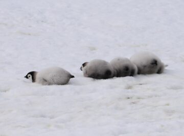
Despite their importance to Arctic ecosystems, we don’t know how many walruses exist. We’re using satellite images and citizen science to count walruses.
This project tests whether satellite imagery can be used to monitor breeding seabirds across the island group.
A BAS science team has returned from Snow Hill emperor penguin colony, where they have conducted survey work, collected guano samples for DNA analysis and deployed the first tracking tags on emperor penguins in the Weddell Sea.
The first comprehensive scientific survey of Zavodovski Island, home to the world’s largest penguin colony.
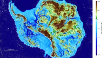
Bedmap3 is a collaborative community project with the aim to produce a new map and datasets of Antarctic ice thickness and bed topography.
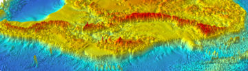
Bedmap is a collaborative community that has produced maps and datasets of Antarctic ice thickness and bed topography
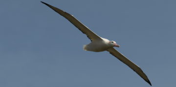
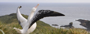
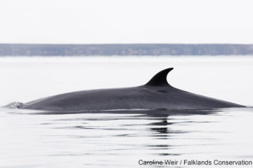
Albatrosses face multiple threats to their long-term survival. Using very high-resolution satellites, we are able to estimate the number of breeding pairs in remote locations.

Higher Predators carries out long-term science to measure changes in Antarctic ecosystems. The aim is to understand the processes that drive these changes.
Many populations of wildlife are remote, inaccessible or difficult to monitor. The advent of sub-metre, Very-High-Resolution (VHR) satellite imagery has enabled us study these animals in a much more efficient way.
Bedmap2 is a suite of gridded products describing surface elevation, ice-thickness and the sea floor and subglacial bed elevation of the Antarctic.
The project has focused on exploiting information present in hyperspectral images, with a view to developing mapping tools to aid in the geological investigations.
No, it’s not a Penguin joke! This World Penguin Day (25 April 2023) we spoke to some of our resident experts, Mike Dunn and Peter Fretwell, to find out more […]
The emperor penguin and Antarctic fur seal are now both Endangered, according to The IUCN Red List of Threatened Species.
Scientists studying satellite images of Antarctica have stumbled upon a discovery that sheds new light on emperor penguins – and reveals a troubling threat to their survival.
The most detailed map yet of the landscape beneath Antarctica’s ice sheet has been assembled by a team of international scientists led from the British Antarctic Survey.
New research released today in Nature Geoscience reveals that vegetation cover on the Antarctic Peninsula has increased more than tenfold in the past four decades.
The first continent-wide mapping study of plant life across Antarctica reveals growth in previously uncharted areas, and is set to inform conservation measures across the region.
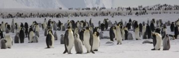
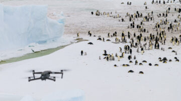
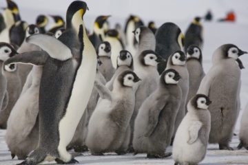
British Antarctic Survey (BAS) is inviting the public to become ‘penguin detectives’ and spend five minutes counting emperor penguins to help with vital research into these iconic animals.
Record low levels of Antarctic sea-ice in late 2023 resulted in breeding failures in a fifth of the continent’s emperor penguin colonies, according to a new study from British Antarctic Survey (BAS).
Scientists from British Antarctic Survey have discovered four previously unknown emperor penguin breeding sites.
Emperor penguin colonies experienced unprecedented breeding failure in a region of Antarctica where there was total sea ice loss in 2022.
In a significant milestone for Antarctic research, detailed and extensive information on ice thickness and bed topography is now available for the first time in a centralised and standardised format. […]
Scientists have discovered a new emperor penguin colony in Antarctica using satellite mapping technology. This new colony makes a total of 62 known emperor penguin colonies around the coastline of […]
This week (17 January) British Antarctic Survey and WWF are inviting the public to become ‘walrus detectives’ and get involved in the Walrus from Space project to help with vital […]
British Antarctic Survey (BAS) and RSPB are recruiting albatross detectives to help to search for wandering albatrosses in satellite images taken from space. This is to help us learn more […]
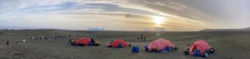
Researchers are heading to the Arctic to begin fieldwork to study walrus populations for the next stage in the Walrus from Space project.
A new dataset featuring hundreds of satellite images of whales has been published to support the development of artificial intelligence systems which will aid crucial conservation work.
An international team of scientists led by British Antarctic Survey have published research today on using new technology to study mass stranding of whales from space and how the technology […]
The Innovation Showcase explains how innovative science and technology is helping or, in future, could substantially help the goals of COP26 and of reducing greenhouse gas emissions, enabling adaptation to climate change or informing action related to climate change.
British Antarctic Survey (BAS) and WWF are seeking the public’s help to search for walrus in thousands of satellite images taken from space, with the aim of learning more about […]
British Antarctic Survey scientists have contributed to a new study published today (3 August) which provides valuable new data highlighting how emperor penguins extinction risk is increased due to rapid […]
Are you ready to explore the world from your living room? British Antarctic Survey scientists are taking part in the online Global Biodiversity Festival 2021. The Global Biodiversity Festival is […]
British Antarctic Survey (BAS) scientists will work with an Artificial Intelligence company after being awarded a contract from the Canadian Space Agency (CSA) to support the protection of an endangered […]
An iceberg is heading towards the sub-Antarctic island of South Georgia. A68a – the size of the UK county of Somerset – broke off from the Larsen C ice shelf […]
A new study using satellite mapping technology reveals there are nearly 20% more emperor penguin colonies in Antarctica than was previously thought. The results provide an important benchmark for monitoring […]
Homeschoolers and penguin fans! Join British Antarctic Survey penguin expert Dr Peter Fretwell this Tuesday 5 May at 2:00pm (UK time) for free online talk ‘Emperor Penguin: Super Bird’. Peter […]
A team of glaciologists has unveiled the most accurate portrait yet of the contours of the land beneath Antarctica’s ice sheet – and, by doing so, has helped identify which […]
A new technique for analysing satellite images may help scientists detect and count stranded whales from space. Researchers tested a new detection method using Very High Resolution (VHR) satellite images […]
In a new study published this week (Wednesday 9 October) in the journal Biological Conservation, an international team of researchers recommends the need for additional measures to protect and conserve […]
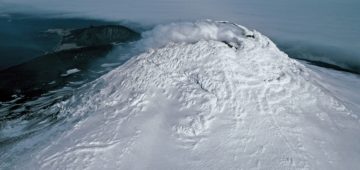
A team of scientists has discovered a rare lava lake on a remote and inaccessible sub-Antarctic island. This volcano in the South Sandwich Islands is only the 8th to be identified worldwide to have a persistent lava lake.
Researchers at British Antarctic Survey have discovered “catastrophic” breeding failure at one of world’s largest emperor penguin colonies.
Large krill swarms in the Southern Ocean could help remove additional carbon from the atmosphere, in a way that is currently ‘hidden’ in global models. The new study is published […]
Scientists have used detailed high-resolution satellite images provided by Maxar Technologies’ DigitalGlobe, to detect, count and describe four different species of whales. Reported this week in the journal Marine Mammal […]
One of Antarctica’s biggest gentoo penguin colonies was repeatedly decimated by eruptions of the Deception Island volcano in recent millennia.
A volcano erupting on a small island in the Sub Antarctic is depositing ash over one of the world’s largest penguin colonies.
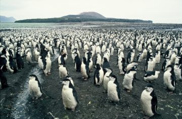
Seabird poo has unique spectral signature visible from satellite images Scientists have discovered that penguin and seabird poo (guano) from colonies around the Antarctic Peninsula has a unique spectral signature […]
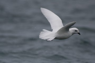
New maps of the polar regions reveal unseen world beneath the ice and highlight dramatic decline in Arctic sea ice cover New maps of the sub-ice features in Antarctica and […]
New research using satellite images reveals that emperor penguins are more willing to relocate than previously thought A new study led by the University of Minnesota offers new insights on […]
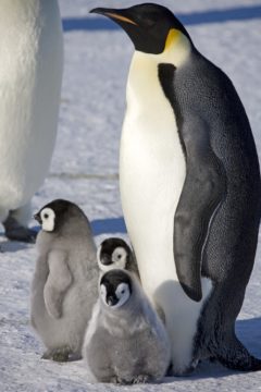
Satellites help spot whales Scientists have demonstrated how new satellite technology can be used to count whales, and ultimately estimate their population size. Using Very High Resolution (VHR) satellite imagery, […]
Antarctic emperor penguins may be adapting to warmer temperatures A new study of four Antarctic emperor penguin colonies suggest that unexpected breeding behaviour may be a sign that the birds […]
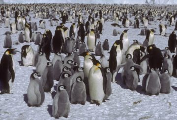
Map makers rewarded for stunning recreation of Antarctic without ice A colourful British Antarctic Survey map has won a coveted award. The map, created by the institution’s MAGIC (Mapping and […]
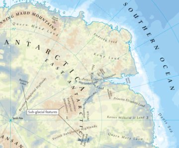
Bedmap2 gives scientists a more detailed view of Antarctica”s landmass Scientists at the British Antarctic Survey have been working with a host of international collaborators to present the most detailed […]
Scientists count penguins from space A new study using satellite mapping technology reveals there are twice as many emperor penguins in Antarctica than was previously thought. The results provide an […]