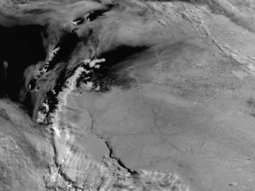
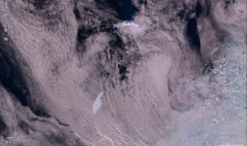
Improving how we measure Antarctic sea ice
QUASAR uses AI to improve Antarctic sea ice measurements from satellites, making climate data more reliable for scientists tracking changes in polar regions.
Andrew Fleming is the Head of the Mapping and Geographic Information Centre at the British Antarctic Survey. He leads the group’s activities covering topographic mapping and delivery of the spatial data infrastructure for BAS, plus wider application of geospatial and remote sensing methods to science and operational projects in the polar regions.
He has led the Polar View project in the Antarctic since 2004, which develops and delivers near-real-time sea ice information to users operating in polar oceans. He plays key roles in international projects concerned with improving sea ice information for mariners, including EU H2020 Arctic PASSION projects and previously the Copernicus Marine Service and H2020 Extreme Earth project. He is actively involved in the International Ice Charting Working Group.
He is involved in projects to exploit hyperspectral data in the Antarctic and with the BAS Artificial Intelligence Lab on methods to track icebergs. He is also involved in projects to widen access to EO data including the ESA Polar Thematic Exploitation Platform. His work involves participation in numerous field- and ship-based campaigns in the Arctic and Antarctic.
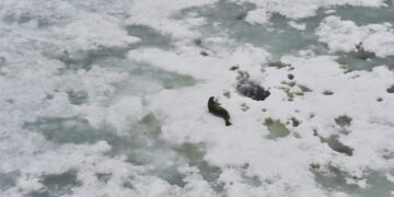
McGinnity, Claire. Bamford, Connor C.G. ORCID record for Bamford, Connor C.G.. Fenney, Nathan ORCID record for Fenney, Nathan. Fleming, Andrew ORCID record for Fleming, Andrew. Forcada, Jaume ORCID record for Forcada, Jaume. Tift, Michael S. Hückstädt, Luis A. Costa, Daniel P. Fretwell, Peter T. ORCID record for Fretwell, Peter T.. (2026) Semi‐automated seal detection on the Western Antarctic Peninsula: an unsupervised machine learning approach for detecting ice seals in aerial survey data.
Evans, Ben R. ORCID record for Evans, Ben R.. Lowe, Alan R. Crawford, Anna ORCID record for Crawford, Anna. Fleming, Andrew ORCID record for Fleming, Andrew. Hosking, Scott J. ORCID record for Hosking, Scott J.. (2026) Icebergs, jigsaw puzzles, and genealogy: automated multi-generational iceberg tracking and lineage reconstruction.
Wagner, Penelope. Blockley, Ed. Brucker, Ludovic. Dierking, Wolfgang. Falkingham, John. Fleming, Andrew ORCID record for Fleming, Andrew. Hughes, Nick. (2026) Editorial: The state of knowledge from operational ice service perspectives: previous and future mandates.
Kostov, Yavor ORCID record for Kostov, Yavor. Holland, Paul R. ORCID record for Holland, Paul R.. Hogan, Kelly A. ORCID record for Hogan, Kelly A.. Smith, James A. ORCID record for Smith, James A.. Jourdain, Nicolas C. ORCID record for Jourdain, Nicolas C.. Mathiot, Pierre. Olivé Abelló, Anna ORCID record for Olivé Abelló, Anna. Fleming, Andrew H. ORCID record for Fleming, Andrew H.. Meijers, Andrew J.S. ORCID record for Meijers, Andrew J.S.. (2026) Modelled dynamics of floating and grounded icebergs, with application to the Amundsen Sea.
Meredith, Michael P. ORCID record for Meredith, Michael P.. Hendry, Katharine R. ORCID record for Hendry, Katharine R.. Abrahamsen, Einar Povl ORCID record for Abrahamsen, Einar Povl. Brearley, J. Alexander ORCID record for Brearley, J. Alexander. Young, Emma ORCID record for Young, Emma. Munday, Dave ORCID record for Munday, Dave. Venables, Hugh ORCID record for Venables, Hugh. Hogg, Anna. Wallis, Benjamin J. Van Landeghem, Katrien. Carvalho, Filipa ORCID record for Carvalho, Filipa. Yool, Andrew ORCID record for Yool, Andrew. Annett, Amber. Garabato, Alberto Naveira. Inall, Mark. Sheen, Katy. Fleming, Andrew ORCID record for Fleming, Andrew. Dumont, Estelle. Glowacki, Oskar. Moffat, Carlos. Fraser, Neil. Gille, Sarah. Alford, Matthew. Jackson, Rebecca. Retallick, Katherine. (2025) Polar Ocean Mixing by Internal Tsunamis (POLOMINTS).
Thorne, Michael ORCID record for Thorne, Michael. von Bock und Polach, Franz. Cziferszky, Andreas ORCID record for Cziferszky, Andreas. Fleming, Andrew ORCID record for Fleming, Andrew. Goodman, Dougal. Kikuchi, Takashi. Kodaira, Tsubasa. Mikami, Kohei. Murayama, Hideaki. Sawamura, Junji. Suominen, Mikko. Tate, Alexander ORCID record for Tate, Alexander. Tuhkuri, Jukka. Wadhams, Peter. Waseda, Takuji. Wilkinson, Jeremy ORCID record for Wilkinson, Jeremy. (2025) A polar oceans shipping information system.
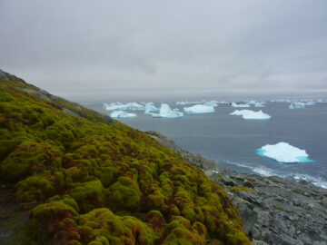
Roland, Thomas P. Bartlett, Oliver T. Charman, Dan J. Anderson, Karen. Hodgson, Dominic A. ORCID record for Hodgson, Dominic A.. Amesbury, Matthew J. Maclean, Ilya. Fretwell, Peter T. ORCID record for Fretwell, Peter T.. Fleming, Andrew ORCID record for Fleming, Andrew. (2024) Sustained greening of the Antarctic Peninsula observed from satellites.
Trathan, Philip N. ORCID record for Trathan, Philip N.. Wienecke, Barbara. Fleming, Andrew ORCID record for Fleming, Andrew. Ireland, Louise ORCID record for Ireland, Louise. (2024) Using telemetry data and the sea ice satellite record to identify vulnerabilities in critical moult habitat for emperor penguins in West Antarctica.
Rogers, Martin S.J. ORCID record for Rogers, Martin S.J.. Fox, Maria ORCID record for Fox, Maria. Fleming, Andrew ORCID record for Fleming, Andrew. van Zeeland, Louisa. Wilkinson, Jeremy ORCID record for Wilkinson, Jeremy. Hosking, J. Scott ORCID record for Hosking, J. Scott. (2024) Sea ice detection using concurrent multispectral and synthetic aperture radar imagery.
Bigg, Grant R. Cropper, T.E. O’Neill, Clare K. Arnold, Alex K. Fleming, Andrew H. ORCID record for Fleming, Andrew H.. Marsh, R. Ivchenko, V. Fournier, Nicolas. Osborne, Mike. Stephens, Robin. (2023) A model for assessing iceberg hazard.
Evans, Ben ORCID record for Evans, Ben. Faul, Anita ORCID record for Faul, Anita. Fleming, Andrew ORCID record for Fleming, Andrew. Vaughan, David G. ORCID record for Vaughan, David G.. Hosking, J. Scott ORCID record for Hosking, J. Scott. (2023) Unsupervised machine learning detection of iceberg populations within sea ice from dual-polarisation SAR imagery.
Tarling, Geraint ORCID record for Tarling, Geraint. Abrahamsen, Povl ORCID record for Abrahamsen, Povl. Lucas, Natasha ORCID record for Lucas, Natasha. Brearley, Alexander ORCID record for Brearley, Alexander. Fleming, Andrew ORCID record for Fleming, Andrew. Shepherd, Andrew. Liszka, Cecilia ORCID record for Liszka, Cecilia. Manno, Clara ORCID record for Manno, Clara. Murphy, Eugene ORCID record for Murphy, Eugene. Meredith, Michael ORCID record for Meredith, Michael. Ratcliffe, Norman ORCID record for Ratcliffe, Norman. Braakmann-Folgmann, Anne. Gerrish, Laura ORCID record for Gerrish, Laura. (2022) The birth and death of ‘megaberg’ A68.
Hagos, Desta Haileselassie. Kakantousis, Theofilos. Vlassov, Vladimir. Sheikholeslami, Sina. Wang, Tianze. Dowling, Jim. Paris, Claudia. Marinelli, Daniele. Weikmann, Giulio. Bruzzone, Lorenzo. Khaleghian, Salman. Krmer, Thomas. Eltoft, Torbjorn. Marinoni, Andrea. Pantazi, Despina-Athanasia. Stamoulis, Georgios. Bilidas, Dimitris. Papadakis, George. Mandilaras, George. Koubarakis, Manolis. Troumpoukis, Antonis. Konstantopoulos, Stasinos. Muerth, Markus. Appel, Florian. Fleming, Andrew H. ORCID record for Fleming, Andrew H.. Cziferszky, Andreas ORCID record for Cziferszky, Andreas. (2021) ExtremeEarth meets satellite data from space.
Koubarakis, Manolis. Stamoulis, George. Bilidas, Dimitris. Ioannidis, Theofilos. Mandilaras, George. Pantazi, Despina-Athanasia. Papadakis, George. Vlassov, Vladimir. Payberah, Amir H. Wang, Tianze. Sheikholeslami, Sina. Hagos, Desta Haileselassie. Bruzzone, Lorenzo. Paris, Claudia. Weikmann, Giulio. Marinelli, Daniele. Eltoft, Torbjørn. Marinoni, Andrea. Kræmer, Thomas. Khaleghian, Salman. Ullah, Habib. Troumpoukis, Antonis. Kostopoulou, Nefeli Prokopaki. Konstantopoulos, Stasinos. Karkaletsis, Vangelis. Dowling, Jim. Kakantousis, Theofilos. Datcu, Mihai. Yao, Wei. Dumitru, Corneliu Octavian. Appel, Florian. Migdall, Silke. Muerth, Markus. Bach, Heike. Hughes, Nick. Everett, Alistair. Kiærbech, Ashild. Pedersen, Joakim Lillehaug. Arthurs, David. Fleming, Andrew ORCID record for Fleming, Andrew. Cziferszky, Andreas ORCID record for Cziferszky, Andreas. Editors: Soille, P. Loekken, S. Albani, S (2021) Artificial Intelligence and big data technologies for Copernicus data: The EXTREMEEARTH project.
Hagos, D.H. Kakantousis, T. Vlassov, V. Sheikholeslami, S. Wang, T. Dowling, J. Fleming, A. ORCID record for Fleming, A.. Cziferszky, A. ORCID record for Cziferszky, A.. Muerth, M. Appel, F. Pantazi, D-A. Bilidas, D. Papadakis, G. Mandilaras, G. Stamoulis, G. Koubarakis, M. Troumpoukis, A. Konstantopoulos, S. Editors: Soille, P. Loekken, S. Albani, S (2021) The ExtremeEarth software architecture for Copernicus earth observation data.
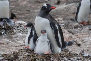
Ratcliffe, Norman ORCID record for Ratcliffe, Norman. Deagle, Bruce. Love, Kieran. Polanowski, Andrea. Fielding, Sophie ORCID record for Fielding, Sophie. Wood, Andrew G. Hill, Simeon ORCID record for Hill, Simeon. Grant, Susie ORCID record for Grant, Susie. Belchier, Mark ORCID record for Belchier, Mark. Fleming, Andrew ORCID record for Fleming, Andrew. Hall, Jonathan. (2021) Changes in prey fields increase the potential for spatial overlap between gentoo penguins and a krill fishery within a marine protected area.
Rainville, Luc. Wilkinson, Jeremy ORCID record for Wilkinson, Jeremy. Durley, Mary Ellen J. Harper, Scott. DiLeo, Julia. Doble, Martin J. Fleming, Andrew ORCID record for Fleming, Andrew. Forcucci, David. Graber, Hans. Hargrove, John T. Haverlack, John. Hughes, Nick. Hembrough, Brett. Jeffries, Martin O. Lee, Craig M. Mendenhall, Brendon. McCormmick, David. Montalvo, Sofia. Stenseth, Adam. Shilling, Geoffrey B. Simmons, Harper L. Toomey, James E. Woods, John. (2020) Improving Situational Awareness in the Arctic Ocean.
Bett, David T. ORCID record for Bett, David T.. Holland, Paul R. ORCID record for Holland, Paul R.. Naveira Garabato, Alberto C. Jenkins, Adrian ORCID record for Jenkins, Adrian. Dutrieux, Pierre. Kimura, Satoshi. Fleming, Andrew ORCID record for Fleming, Andrew. (2020) The impact of the Amundsen Sea freshwater balance on ocean melting of the West Antarctic Ice Sheet.
Wagner, Penelope Mae. Hughes, Nick. Bourbonnais, Pascale. Stroeve, Julienne. Rabenstein, Lasse. Bhatt, Uma. Little, Joe. Wiggins, Helen. Fleming, Andrew ORCID record for Fleming, Andrew. (2020) Sea-ice information and forecast needs for industry maritime stakeholders.
Le Traon, Pierre Yves. Reppucci, Antonio. Alvarez Fanjul, Enrique. Aouf, Lotfi. Behrens, Arno. Belmonte, Maria. Bentamy, Abderrahim. Bertino, Laurent. Brando, Vittorio Ernesto. Kreiner, Matilde Brandt. Benkiran, Mounir. Carval, Thierry. Ciliberti, Stefania A. Claustre, Hervé. Clementi, Emanuela. Coppini, Giovanni. Cossarini, Gianpiero. De Alfonso Alonso-Muñoyerro, Marta. Delamarche, Anne. Dibarboure, Gerald. Dinessen, Frode. Drevillon, Marie. Drillet, Yann. Faugere, Yannice. Fernández, Vicente. Fleming, Andrew ORCID record for Fleming, Andrew. Garcia-Hermosa, M. Isabel. Sotillo, Marcos García. Garric, Gilles. Gasparin, Florent. Giordan, Cedric. Gehlen, Marion. Gregoire, Marilaure L. Guinehut, Stephanie. Hamon, Mathieu. Harris, Chris. Hernandez, Fabrice. Hinkler, Jørgen B. Hoyer, Jacob. Karvonen, Juha. Kay, Susan. King, Robert. Lavergne, Thomas. Lemieux-Dudon, Benedicte. Lima, Leonardo. Mao, Chongyuan. Martin, Matthew J. Masina, Simona. Melet, Angelique. Buongiorno Nardelli, Bruno. Nolan, Glenn. Pascual, Ananda. Pistoia, Jenny. Palazov, Atanas. Piolle, Jean Francois. Pujol, Marie Isabelle. Pequignet, Anne Christine. Peneva, Elisaveta. Pérez Gómez, Begoña. Petit de la Villeon, Loic. Pinardi, Nadia. Pisano, Andrea. Pouliquen, Sylvie. Reid, Rebecca. Remy, Elisabeth. Santoleri, Rosalia. Siddorn, John ORCID record for Siddorn, John. She, Jun. Staneva, Joanna. Stoffelen, Ad. Tonani, Marina. Vandenbulcke, Luc. von Schuckmann, Karina. Volpe, Gianluca. Wettre, Cecilie. Zacharioudaki, Anna. (2019) From observation to information and users: The Copernicus Marine Service perspective.
Koubarakis, Manolis. Bereta, Konstantina. Bilidas, Dimitris. Giannousis, Konstantinos. Ioannidis, Theofilos. Pantazi, Despina-Athanasia. Stamoulis, George. Haridi, Seif. Vlassov, Vladimir. Bruzzone, Lorenzo. Paris, Claudia. Eltoft, Torbjørn. Krämer, Thomas. Charalabidis, Angelos. Karkaletsis, Vangelis. Konstantopoulos, Stasinos. Dowling, Jim. Kakantousis, Theofilos. Datcu, Mihai. Dumitru, Corneliu Octavian. Appel, Florian. Bach, Heike. Migdall, Silke. Hughes, Nick. Arthurs, David. Fleming, Andrew ORCID record for Fleming, Andrew. (2019) From Copernicus Big Data to Extreme Earth Analytics.
Barnes, David K.A. ORCID record for Barnes, David K.A.. Fleming, Andrew ORCID record for Fleming, Andrew. Sands, Chester J. ORCID record for Sands, Chester J.. Quartino, Maria Liliana. Deregibus, Dolores. (2018) Icebergs, sea ice, blue carbon and Antarctic climate feedbacks.
Zakharov, Igor. Puestow, Thomas. Fleming, Andrew ORCID record for Fleming, Andrew. Deepakumara, Janaka. Power, Desmond. (2018) Detection and discrimination of icebergs and ships using satellite altimetry.
Black, Martin ORCID record for Black, Martin. Riley, Teal R. ORCID record for Riley, Teal R.. Ferrier, Graham. Fleming, Andrew H. ORCID record for Fleming, Andrew H.. Fretwell, Peter T. ORCID record for Fretwell, Peter T.. (2016) Automated lithological mapping using airborne hyperspectral thermal infrared data: A case study from Anchorage Island, Antarctica.
Hughes, Kevin A. ORCID record for Hughes, Kevin A.. Ireland, Louise ORCID record for Ireland, Louise. Convey, Peter ORCID record for Convey, Peter. Fleming, Andrew H. ORCID record for Fleming, Andrew H.. (2015) Assessing the effectiveness of specially protected areas for conservation of Antarctica’s botanical diversity.
Holland, P.R. ORCID record for Holland, P.R.. Brisbourne, A. ORCID record for Brisbourne, A.. Corr, H.F.J. McGrath, D. Purdon, K. Paden, J. Fricker, H.A. Paolo, F.S. Fleming, A.H. ORCID record for Fleming, A.H.. (2015) Oceanic and atmospheric forcing of Larsen C Ice-Shelf thinning.
Fretwell, P.T. ORCID record for Fretwell, P.T.. Phillips, R.A. ORCID record for Phillips, R.A.. Brooke, M. de L. Fleming, A.H. ORCID record for Fleming, A.H.. McArthur, A. (2014) Using the unique spectral signature of guano to identify unknown seabird colonies.
Pope, Allen. Rees, W. Fox, Adrian ORCID record for Fox, Adrian. Fleming, Andrew ORCID record for Fleming, Andrew. (2014) Open access data in polar and cryospheric remote sensing.
Black, Martin ORCID record for Black, Martin. Fleming, Andrew ORCID record for Fleming, Andrew. Riley, Teal ORCID record for Riley, Teal. Ferrier, Graham. Fretwell, Peter ORCID record for Fretwell, Peter. McFee, John. Achal, Stephen. Diaz, Alejandra Umana. (2014) On the Atmospheric Correction of Antarctic Airborne Hyperspectral Data.
Dutrieux, P. ORCID record for Dutrieux, P.. Vaughan, D.G. ORCID record for Vaughan, D.G.. Corr, H.F.J. Jenkins, A. ORCID record for Jenkins, A.. Holland, P.R. ORCID record for Holland, P.R.. Joughin, I. Fleming, A.H. ORCID record for Fleming, A.H.. (2013) Pine Island Glacier ice shelf melt distributed at kilometre scales.
Fox, Adrian ORCID record for Fox, Adrian. Herbert, David. Fretwell, Peter ORCID record for Fretwell, Peter. Fleming, Andrew ORCID record for Fleming, Andrew. (2013) SCAR Antarctic Digital Database V 6.0.
Seear, Paul J. Goodall-Copestake, William P. ORCID record for Goodall-Copestake, William P.. Fleming, Andrew H. ORCID record for Fleming, Andrew H.. Rosato, Ezio. Tarling, Geraint A. ORCID record for Tarling, Geraint A.. (2012) Seasonal and spatial influences on gene expression in Antarctic krill Euphausia superba.
Murphy, E. J. ORCID record for Murphy, E. J.. Watkins, J.L. Trathan, P.N. ORCID record for Trathan, P.N.. Reid, K. Meredith, M.P. ORCID record for Meredith, M.P.. Hill, S.L. ORCID record for Hill, S.L.. Thorpe, S.E. ORCID record for Thorpe, S.E.. Johnston, N.M. ORCID record for Johnston, N.M.. Clarke, A. ORCID record for Clarke, A.. Tarling, G.A. ORCID record for Tarling, G.A.. Collins, M.A. ORCID record for Collins, M.A.. Forcada, J. ORCID record for Forcada, J.. Atkinson, A. Ward, P. Staniland, I.J. ORCID record for Staniland, I.J.. Pond, D.W. Cavanagh, R.A. ORCID record for Cavanagh, R.A.. Shreeve, R.S. Korb, R.E. Whitehouse, M.J. Rodhouse, P.G. Enderlein, P. Hirst, A.G. Martin, A.R. Briggs, D.R. Cunningham, N.J. Fleming, A.H. ORCID record for Fleming, A.H.. Editors: Rogers, Alex D. Johnston, Nadine M. ORCID record for Johnston, Nadine M.. Murphy, Eugene J. ORCID record for Murphy, Eugene J.. Clarke, Andrew ORCID record for Clarke, Andrew (2012) Spatial and Temporal Operation of the Scotia Sea Ecosystem.
Fretwell, Peter T. ORCID record for Fretwell, Peter T.. LaRue, Michelle A. Morin, Paul. Kooyman, Gerald L. Wienecke, Barbara. Ratcliffe, Norman ORCID record for Ratcliffe, Norman. Fox, Adrian J. ORCID record for Fox, Adrian J.. Fleming, Andrew H. ORCID record for Fleming, Andrew H.. Porter, Claire. Trathan, Phil N. ORCID record for Trathan, Phil N.. (2012) An Emperor Penguin population estimate: The first global, synoptic survey of a species from space.
Fleming, A.H. ORCID record for Fleming, A.H.. Korb, R.E. (2012) A comparison of satellite and cruise chlorophyll-a measurements in the Scotia Sea, Antarctica.
Hughes, Kevin A. ORCID record for Hughes, Kevin A.. Fretwell, Peter ORCID record for Fretwell, Peter. Rae, Joanna. Holmes, Keith. Fleming, Andrew ORCID record for Fleming, Andrew. (2012) Untouched Antarctica: mapping a finite and diminishing environmental resource.
Pritchard, Hamish D. ORCID record for Pritchard, Hamish D.. Luthcke, S.B. Fleming, Andrew H. ORCID record for Fleming, Andrew H.. (2011) Understanding ice-sheet mass balance: progress in satellite altimetry and gravimetry.
Fretwell, Peter T. ORCID record for Fretwell, Peter T.. Convey, Peter ORCID record for Convey, Peter. Fleming, Andrew H. ORCID record for Fleming, Andrew H.. Peat, Helen J. ORCID record for Peat, Helen J.. Hughes, Kevin A. ORCID record for Hughes, Kevin A.. (2011) Detecting and mapping vegetation distribution on the Antarctic Peninsula from remote sensing data.
Beekmans, Bas W.P.M. Forcada, Jaume ORCID record for Forcada, Jaume. Murphy, Eugene J. ORCID record for Murphy, Eugene J.. De Baar, Hein J.W. Bathmann, Ulrich V. Fleming, Andrew H. ORCID record for Fleming, Andrew H.. (2011) Generalised additive models to investigate environmental drivers of Antarctic minke whale (Balaenoptera bonaerensis) spatial density in austral summer.
Trathan, Phil N. ORCID record for Trathan, Phil N.. Bishop, C. Maclean, G. Brown, P. Fleming, Andrew ORCID record for Fleming, Andrew. Collins, Martin Anthony ORCID record for Collins, Martin Anthony. (2011) Linear tracks and restricted temperature ranges characterise penguin foraging pathways.
Fleming, Andrew ORCID record for Fleming, Andrew. Bowyer, Paul. (2011) Sat nav.
Bindschadler, Robert. Vornberger, Patricia. Fleming, Andrew ORCID record for Fleming, Andrew. Fox, Adrian ORCID record for Fox, Adrian. Mullins, Jerry. Binnie, Douglas. Paulsen, Sara Jean. Granneman, Brian. Gorodetzky, David. (2010) The Landsat Image Mosaic of Antarctica.
Peck, Lloyd S. ORCID record for Peck, Lloyd S.. Barnes, David K.A. ORCID record for Barnes, David K.A.. Cook, Alison J. Fleming, Andrew H. ORCID record for Fleming, Andrew H.. Clarke, Andrew ORCID record for Clarke, Andrew. (2010) Negative feedback in the cold: ice retreat produces new carbon sinks in Antarctica.
Atkinson, A. Siegel, V. Pakhomov, E.A. Rothery, P. Loeb, V. Ross, R.M. Quetin, L.B. Schmidt, K. Fretwell, P. ORCID record for Fretwell, P.. Murphy, E.J. ORCID record for Murphy, E.J.. Tarling, G.A. ORCID record for Tarling, G.A.. Fleming, A.H. ORCID record for Fleming, A.H.. (2009) Oceanic circumpolar habitats of Antarctic krill.
Murphy, E.J. ORCID record for Murphy, E.J.. Watkins, J.L. Trathan, P.N. ORCID record for Trathan, P.N.. Reid, K. Meredith, M.P. ORCID record for Meredith, M.P.. Thorpe, S.E. ORCID record for Thorpe, S.E.. Johnston, N.M. ORCID record for Johnston, N.M.. Clarke, A. ORCID record for Clarke, A.. Tarling, G.A. ORCID record for Tarling, G.A.. Collins, M.A. ORCID record for Collins, M.A.. Forcada, J. ORCID record for Forcada, J.. Shreeve, R.S. Atkinson, A. Korb, R. Whitehouse, M.J. Ward, P. Rodhouse, P.G. Enderlein, P. Hirst, A.G. Martin, A.R. Hill, S.L. ORCID record for Hill, S.L.. Staniland, I.J. ORCID record for Staniland, I.J.. Pond, D.W. Briggs, D.R. Cunningham, N.J. Fleming, A.H. ORCID record for Fleming, A.H.. (2007) Spatial and temporal operation of the Scotia Sea ecosystem: a review of large-scale links in a krill centred food web.
Warren, N.L. Trathan, P.N. ORCID record for Trathan, P.N.. Forcada, J. ORCID record for Forcada, J.. Fleming, A.H. ORCID record for Fleming, A.H.. Jessopp, M.J. (2007) Distribution of post-weaning Antarctic fur seal Arctocephalus gazella pups at South Georgia.
Bett, D., Holland, P., Naveira Garabato, A., Jenkins, A., Dutrieux, P., Kimura, S., & Fleming, A. (2020). Model results of Amundsen Sea freshwater tracing and iceberg variation simulations (Version 1.0) [Data set]. UK Polar Data Centre, Natural Environment Research Council, UK Research & Innovation. https://doi.org/10.5285/8ad04d77-6a41-419a-b0d7-18eee743bf26
Fleming, A. (2009). Polar View – satellite Earth observation data (Version 1.0) [Data set]. NERC EDS UK Polar Data Centre. https://data.bas.ac.uk/full-record.php?id=GB/NERC/BAS/PDC/00360
QUASAR uses AI to improve Antarctic sea ice measurements from satellites, making climate data more reliable for scientists tracking changes in polar regions.
ANTARCTICA INSYNC brings together researchers from around the world including British Antarctic Survey to study the continent and the Southern Ocean at the same time.
PRESCIENT supports long-term, strategically important measurements and capabilities for the wider science community.
Arctic PASSION brought together international partners, including Indigenous and local communities, to improve how we monitor the rapidly changing Arctic and make environmental data freely available to those who need it.
This project is developing digital twins of Antarctic and Arctic environments and resources. A digital twin makes it possible to test “what if” questions far more quickly than traditional computer models.
AI4EO Accelerator applies artificial intelligence to the large amounts of Earth Observation satellite data now available,
The aim of this project is to develop a next generation sea ice information service by integrating and building on a wide range of European and national funded activities which incorporate many of the required components.
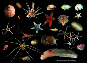
The Larsen-C Benthos project studied benthic biodiversity on the seabed exposed by the 2017 calving of the Larsen-C Ice Shelf.
Polar TEP provides polar researchers with access to computing resources, earth observation and other data, and software tools in the cloud.
Optimising situational awareness in the Arctic through integrated space technologies
The Copernicus marine environment monitoring service provides regular and systematic reference information on the state of the physical oceans and regional seas.
The project has focused on exploiting information present in hyperspectral images, with a view to developing mapping tools to aid in the geological investigations.
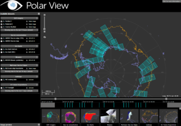
Polar View delivers information about sea ice direct to ships operating in the Southern Ocean.
Over the last decade, digital technologies, including Artificial Intelligence, developed rapidly as did our capability to monitor our home planet from space with Earth Observation satellites. How can we most […]
Andrew Fleming and Anita Faul present their research at the First Artificial Intelligence for Copernicus Workshop
Wilkins Ice Shelf Breakup from AHF on Vimeo.
ESRIN rolling archive Kiruna rolling archive PO.DAAC NSIDC MODIS Rapid Response LP.DAAC GloVis NESDIS NEODC NEODAAS BADC BODC CEH EIDC NODC NASA Ocean Color NASA Giovanni AVISO GHRSST NGDC MOA […]
General Polar View project site – www.polarview.org Polar View Antarctic node – www.polarview.aq Google Earth links Envisat ASAR WSM N1 files – last 24 hours Envisat ASAR WSM N1 files […]
Satellite pictures, from the European Space Agency (ESA), revealed that the 40-km (25 mile) long strip of floating ice believed to pin the Wilkins Ice Shelf in place had snapped […]
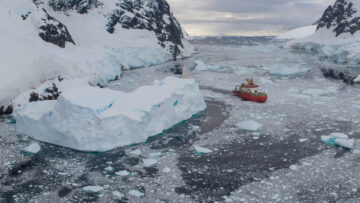
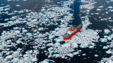
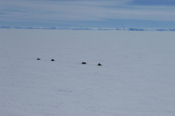
Specialist divers will be entering the icy waters of the Weddell Sea, Antarctica this festive season (22-29 December) as part of a groundbreaking mission to test RRS Sir David Attenborough’s (SDA) ability to navigate through challenging sea ice conditions.
New research released today in Nature Geoscience reveals that vegetation cover on the Antarctic Peninsula has increased more than tenfold in the past four decades.
Scientists at British Antarctic Survey are using satellite images to track the colossal iceberg A23a.
The RRS Sir David Attenborough completes ice trials during its maiden voyage to Antarctica – a critical milestone in the commissioning of Britain’s new polar ship. This is the first […]
A research mission to determine the impact of the giant A-68a iceberg on one of the world’s most important ecosystems departs from Stanley in the Falkland Islands today (2 February […]
Gentoo penguins are benefiting from a newly enlarged no-fishing zone (known as a No-Take Zone NTZ) around the sub-Antarctic island of South Georgia following British Antarctic Survey (BAS) tracking research […]
An iceberg is heading towards the sub-Antarctic island of South Georgia. A68a – the size of the UK county of Somerset – broke off from the Larsen C ice shelf […]
A team of scientists, led by British Antarctic Survey (BAS), is planning an urgent mission to investigate a mysterious marine ecosystem that’s been hidden beneath an Antarctic ice shelf for […]
BAS uses aerial photography taken with this camera for topographic, geological and vegetation mapping, interpreting satellite imagery and counting populations of penguins and seals.
After months of ‘hanging by a thread’ a vast iceberg the size of Norfolk has finally broken off Antarctica’s Larsen C Ice Shelf. Around 30 metres of this 190m thick […]
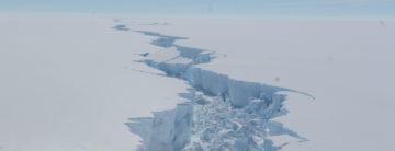
A huge iceberg, roughly the size of Norfolk, looks set to break away from the Larsen C ice shelf on the Antarctic Peninsula. Larsen C is more than twice the size […]
Seabird poo has unique spectral signature visible from satellite images Scientists have discovered that penguin and seabird poo (guano) from colonies around the Antarctic Peninsula has a unique spectral signature […]
British Antarctic Survey remote sensing expert Andrew Fleming is part of a new European project to aid ships’ navigation in ice-infested waters in the European Arctic and the Baltic Sea […]