A new technique for analysing satellite images may help scientists detect and count stranded whales from space. Researchers tested a new detection method using Very High Resolution (VHR) satellite images from Maxar Technologies of the biggest mass stranding of baleen whales yet recorded. It is hoped that in the future the technique will lead to real-time information as stranding events happen.
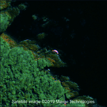
Satellite image of a stranded whale
The study, published this week in the journal PLoS ONE by scientists from British Antarctic Survey and four Chilean research institutes, could revolutionise how stranded whales, that are dead in the water or beached, are detected in remote places.
In 2015, over 340 whales, most of them sei whales, were involved in a mass-stranding in a remote region of Chilean Patagonia. The stranding was not discovered for several weeks owing to the remoteness of the region. Aerial and boat surveys assessed the extent of the mortality several months after discovery.
The researchers studied satellite images covering thousands of kilometres of coastline, which provided an early insight into the extent of the mortality. They could identify the shape, size and colour of the whales, especially after several weeks when the animals turned pink and orange as they decomposed. A greater number of whales were counted in the images captured soon after the stranding event than from the local surveys.
Many coastal nations have mammal stranding networks recognising that this is a crucial means to monitor the health of the local environment, especially for providing first notice of potential marine contamination and harmful algal blooms.
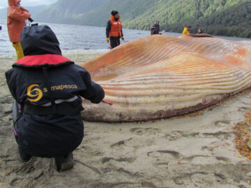
Deceased stranded sei whale in Chile
Author and whale biologist Dr Jennifer Jackson at British Antarctic Survey says:
“The causes of marine mammal strandings are poorly understood and therefore information gathered helps understand how these events may be influenced by overall health, diet, environmental pollution, regional oceanography, social structures and climate change.
“As this new technology develops, we hope it will become a useful tool for obtaining real-time information. This will allow local authorities to intervene earlier and possibly help with conservation efforts.”
Lead author, remote sensing specialist Dr Peter Fretwell at British Antarctic Survey says:
“This is an exciting development in monitoring whales from space. Now we have a higher resolution ‘window’ on our planet, satellite imagery may be a fast and cost-effective alternative to aerial surveys allowing us to assess the extent of mass whale stranding events, especially in remote and inaccessible areas.”
Using remote sensing to detect whale strandings in remote areas: the case of sei whales mass mortality in Chilean Patagonia by Peter T. Fretwell1*, Jennifer A. Jackson1, Mauricio J. Ulloa Encina2, Vreni Häussermann 3, Maria J. Perez Alvarez4,5,6, Carlos Olavarría7, Carolina S.Gutstein8, 9 is published in the journal PLoS ONE here.