DATA AS ART #07
Thin section Thin sections of geological samples viewed under cross-polarised light can reveal valuable information about the origin of the rocks they come from. This helps understand the geological process […]
2023 Awarded Prestwich Medal: Geological Society
2023 Board of Directors (SAERI Falklands Limited)
2020 Science Advisory Committee: South Atlantic Environmental Research Institute
2018 Trustee: South Atlantic Environmental Research Institute
2017 President of British Science Association (Geology)
2016-2018 External examiner (Part II) University of Cambridge
2015 Deputy science leader: Geology & Geophysics
2011 Promoted to Band 4 scientist
2010 Awarded Polar Medal
2005-2015 Geologist, Head of Long Term Survey and Mapping department, Geological Science, British Antarctic Survey
2000-2005 Geochemist, MAMOG project, Geological Sciences, British Antarctic Survey
2004 Awarded Laws Prize, British Antarctic Survey
2000 Promoted to Senior Scientific Officer
1997-2000 Higher Scientific Officer, British Antarctic Survey
1995-1997 Contract geochemist, British Antarctic Survey
1991-1995 Ph.D. Geochemistry, University of Bristol
1988-1991 B.Sc. (Hons) Geology, University of Leicester
Thirty years experience in petrology and geochemistry of many aspects of continental and oceanic volcanism. Over 30 years experience in Antarctic geology, including sixteen Antarctic field seasons and two marine geology/geophysics cruises. Recent research has investigated the origins of silicic volcanism in the Antarctic Peninsula and Patagonian South America, geochronology and geochemistry of Gondwana break-up magmatism, and volcanism of the South Sandwich intra-oceanic island arc. Previous experience includes the petrogenesis of Recent alkaline and carbonatite volcanism of Germany. Over 120 publications since 1997 in refereed journals.
2026
2025
2024
2023
2022
2021
2020
2019
2018
2017
2016
2015
2014
2013
2012
2011
2010
2009
2008
2007
2006
2005
2004
2003
2002
2001
2000
1999
1998
1997
1996
Twinn, G. Riley, Teal R. ORCID record for Riley, Teal R.. Carter, A. (2026) Origins of Antarctic Peninsula Topography: Constraints From Low Temperature Apatite Thermochronometry.
Archibald, Emily J. Marschalek, James W. Muxworthy, Adrian R. Riley, Teal ORCID record for Riley, Teal. Hillenbrand, Claus-Dieter ORCID record for Hillenbrand, Claus-Dieter. Jordan, Tom ORCID record for Jordan, Tom. Vermeesch, Pieter. Flowerdew, Michael J. Siegert, Martin. Hodgson, Dominic A. ORCID record for Hodgson, Dominic A.. van de Flierdt, Tina. (2026) Geochemical characterisation of the Ellsworth-Whitmore Mountains crustal block: a critical piece in the puzzle to unravel ice retreat in West Antarctica.
Riley, Teal R. ORCID record for Riley, Teal R.. Carter, Andrew. Flowerdew, Michael J. Millar, Ian L. Whitehouse, Martin J. (2026) South Georgia in a West Gondwana context: detrital zircon geochronology of a late Permian accretionary complex.
Monteath, Alistair J. ORCID record for Monteath, Alistair J.. Young, Emma F. ORCID record for Young, Emma F.. Dawson, Hannah R.S. Jensen, Britta J.L. Smellie, John L. Manning, Christina J. Riley, Teal R. ORCID record for Riley, Teal R.. Jordan, Tom A. ORCID record for Jordan, Tom A.. Roberts, Stephen J. ORCID record for Roberts, Stephen J.. (2025) Major-Minor-Trace Element Analyses and Oceanographic Modeling Confirms Circumpolar Transport of the 1962 Protector Shoal Pumice Raft.
Riley, Teal R. ORCID record for Riley, Teal R.. Carter, Andrew. (2025) Age of granitoid magmatism in South Georgia and correlations to southern Patagonia and the northern Antarctic Peninsula.
Jordan, Tom A. ORCID record for Jordan, Tom A.. Johnson, Joanne S. ORCID record for Johnson, Joanne S.. Riley, Teal R. ORCID record for Riley, Teal R.. Conrad, Ethan. Carter, Andrew. (2025) Subglacial geology and palaeo flow of Pine Island Glacier from combining glacial erratics with geophysics.
Riley, Teal R. ORCID record for Riley, Teal R.. MacDonald, David I.M. Cantrill, David J. Crame, J. Alistair ORCID record for Crame, J. Alistair. Curtis, Michael L. (2025) The geology of Alexander Island (Antarctic Peninsula): a new 1:500 000 geological map.
North, Ryan. White, Lloyd T. Riley, Teal R. ORCID record for Riley, Teal R.. Tanner, Dominique. Barrows, Timothy T. (2025) Age and geology of granitoids in northeast Palmer Land, Antarctic Peninsula.
Jordan, Tom A. ORCID record for Jordan, Tom A.. Lowe, Maximilian ORCID record for Lowe, Maximilian. Riley, Teal R. ORCID record for Riley, Teal R.. (2025) New Insights Into Western Antarctic Peninsula Magmatism From Joint Inversion of UAV Magnetic and Gravity Data.
Riley, Teal R. ORCID record for Riley, Teal R.. Carter, Andrew. Hunter, Morag A. Millar, Ian L. Flowerdew, Michael J. Curtis, Michael L. Hodgson, Dominic A. ORCID record for Hodgson, Dominic A.. (2025) Provenance and correlation of Late Permian successions from the Falkland/Malvinas Islands with West Gondwana: implications for a Natal Embayment palaeo-location.
Riley, T.R ORCID record for Riley, T.R. Curtis, M.L. Crame, J.A. ORCID record for Crame, J.A.. Cantrill, D.J. Macdonald, D.I.M. (2025) Geological map of Alexander Island, Antarctic Peninsula.
Eren, Metin. Lycett, Stephen. Bebber, Michelle. Key, Alastair. Buchanan, Briggs. Finestone, Emma. Benson, Joseph. Biermann Gurbuz, Rebecca. Cebeiro, Adela. Garba, Roman. Grunow, Anne. Lovejoy, C. Owen. Macdonald, Danielle. Maletic, Erica. Miller, Logan. Ortiz, Joseph. Paige, Jonathan. Pargeter, Justin. Proffitt, Tomos. Raghanti, Mary Ann. Riley, Teal ORCID record for Riley, Teal. Rose, Jeffrey I. Singer, David M. Walker, Robert. (2025) What can lithics tell us about hominin technology’s ‘primordial soup’? An origin of stone knapping via the emulation of Mother Nature.
Johnson, Joanne S. ORCID record for Johnson, Joanne S.. Nichols, Keir A. Riley, Teal R. ORCID record for Riley, Teal R.. Venturelli, Ryan A. Hodgson, Dominic A. ORCID record for Hodgson, Dominic A.. Balco, Greg. Hall, Brenda. Smith, James A ORCID record for Smith, James A. Woodward, John. (2025) Glacial geology of the Hudson Mountains, Amundsen Sea sector, West Antarctica.
Jordan, Tom A. ORCID record for Jordan, Tom A.. Riley, Teal ORCID record for Riley, Teal. (2024) Reinvestigating the Dufek Intrusion, through joint gravity and magnetic models.
Lowe, Maximilian ORCID record for Lowe, Maximilian. Jordan, Tom ORCID record for Jordan, Tom. Moorkamp, Max. Ebbing, Jörg. Green, Chris. Lösing, Mareen. Riley, Teal ORCID record for Riley, Teal. Larter, Robert ORCID record for Larter, Robert. (2024) The 3D Crustal Structure of the Wilkes Subglacial Basin, East Antarctica, Using Variation of Information Joint Inversion of Gravity and Magnetic Data.
Gibson, S.A. Crosby, J.C. Day, J.A.F. Stuart, F.M. DiNicola, L. Riley, T.R. ORCID record for Riley, T.R.. (2024) Systematic behaviour of 3He/4He in Earth’s continental mantle.
Riley, Teal R. ORCID record for Riley, Teal R.. Flowerdew, Michael J. Carter, Andrew. Curtis, Michael L. Millar, Ian L. Crame, J. Alistair ORCID record for Crame, J. Alistair. Whitehouse, Martin J. (2024) Tracking the tempo of a continental margin arc: insights from a forearc succession in West Antarctica.
Bastias-Silva, J. Burton-Johnson, A. ORCID record for Burton-Johnson, A.. Chew, D. Riley, T. ORCID record for Riley, T.. Jara, W. Chiaradia, M. (2024) A temporal control on the isotopic compositions of the Antarctic Peninsula arc.
Anderson, D.W. Saal, A.E. Mallick, S. Wang, J. Riley, T.R. ORCID record for Riley, T.R.. Keller, R.A. Haase, K.M. (2023) Source variations in volatile contents of Bransfield Strait back-arc and Phoenix/West Scotia mid-ocean ridge lavas, northern Antarctic Peninsula.
Riley, Teal R. ORCID record for Riley, Teal R.. Burton-Johnson, Alex ORCID record for Burton-Johnson, Alex. Hogan, Kelly A. ORCID record for Hogan, Kelly A.. Carter, Andrew. Leat, Philip T. (2023) Cretaceous – Paleogene tectonic reconstructions of the South Scotia Ridge and implications for the initiation of subduction in the Scotia Sea.
Flowerdew, Michael J. Fleming, Edward J. Chew, David M. Morton, Andrew C. Frei, Dirk. Benedictus, Aukje. Omma, Jenny. Riley, Teal. R. ORCID record for Riley, Teal. R.. Badenszki, Eszter. Whitehouse, Martin J. (2023) The Importance of Eurekan Mountains on Cenozoic Sediment Routing on the Western Barents Shelf.
Riley, Teal R. ORCID record for Riley, Teal R.. Millar, Ian L. Carter, Andrew. Flowerdew, Michael J. Burton-Johnson, Alex ORCID record for Burton-Johnson, Alex. Bastias, Joaquin. Storey, Craig D. Castillo, Paula. Chew, David. Whitehouse, Martin J. (2023) Evolution of an accretionary complex (LeMay Group) and terrane translation in the Antarctic Peninsula.
Eren, Metin I. Bebber, Michelle R. Buchanan, Briggs. Grunow, Anne. Key, Alastair. Lycett, Stephen J. Maletic, Eric. Riley, Teal ORCID record for Riley, Teal. (2023) Antarctica as a ‘natural laboratory’ for the critical assessment of the archaeological validity of early stone tool sites.
Bastías, Joaquín. Chew, David. Villanueva, Camila. Riley, Teal ORCID record for Riley, Teal. Manfroi, Joseline. Trevisan, Cristine. Leppe, Marcelo. Castillo, Paula. Poblete, Fernando. Tetzner, Dieter ORCID record for Tetzner, Dieter. Giuliani, Gregory. López, Bastián. Chen, Hong. Zheng, Guang-Gao. Zhao, Yue. Rauch, Anna. Jaña, Ricardo A. (2023) The South Shetland Islands, Antarctica: unified lithostratigraphy and geological map.
Riley, Teal R. ORCID record for Riley, Teal R.. Burton-Johnson, Alex ORCID record for Burton-Johnson, Alex. Flowerdew, Michael J. Poblete, Fernando. Castillo, Paula. Hervé, Francisco. Leat, Philip T. Millar, Ian L. Bastias, Joaquin. Whitehouse, Martin J. (2022) Palaeozoic – Early Mesozoic geological history of the Antarctic Peninsula and correlations with Patagonia: Kinematic reconstructions of the proto-Pacific margin of Gondwana.
Anderson, D.W. Saal, A.E. Lee, J.I. Mallick, S.M. Riley, T.R. ORCID record for Riley, T.R.. Keller, R.A. Haase, K.M. (2022) Tracing mantle components and the effect of subduction processes beneath the northern Antarctic Peninsula.
Burton-Johnson, A. ORCID record for Burton-Johnson, A.. Riley, T.R. ORCID record for Riley, T.R.. Harrison, R.J. Mac Niocaill, C. Muraszko, J.R. Rowley, P.D. (2022) Does tectonic deformation control episodic continental arc magmatism? Evidence from granitic magnetic fabrics (AMS).
Riley, Teal R. ORCID record for Riley, Teal R.. Carter, Andrew. Burton-Johnson, Alex ORCID record for Burton-Johnson, Alex. Leat, Philip T. Hogan, Kelly A. ORCID record for Hogan, Kelly A.. Bown, Paul R. (2022) Crustal block origins of the South Scotia Ridge.
Hodgson, Dominic A. ORCID record for Hodgson, Dominic A.. Jordan, Tom A. ORCID record for Jordan, Tom A.. Ross, Neil ORCID record for Ross, Neil. Riley, Teal R. ORCID record for Riley, Teal R.. Fretwell, Peter ORCID record for Fretwell, Peter. (2022) Drainage and refill of an Antarctic Peninsula subglacial lake reveal an active subglacial hydrological network.
Bastias, Joaquin. Spikings, Richard. Riley, Teal ORCID record for Riley, Teal. Chew, David. Grunow, Anne. Ulianov, Alexey. Chiaradia, Massimo. Burton-Johnson, Alex ORCID record for Burton-Johnson, Alex. (2022) Cretaceous magmatism in the Antarctic Peninsula and its tectonic implications.
Twinn, G. Riley, T. ORCID record for Riley, T.. Fox, M. Carter, A. (2022) Thermal history of the southern Antarctic Peninsula during Cenozoic oblique subduction.
Gao, Liang. Pei, Junling. Zhao, Yue. Yang, Zhenyu. Riley, Teal R. ORCID record for Riley, Teal R.. Liu, Xiaochun. Zhang, Shuan-Hong. Liu, Jian-Min. (2021) New paleomagnetic constraints on the Cretaceous tectonic framework of the Antarctic Peninsula.
Riley, Teal R. ORCID record for Riley, Teal R.. Burton-Johnson, Alex ORCID record for Burton-Johnson, Alex. Leat, Philip T. Hogan, Kelly A. ORCID record for Hogan, Kelly A.. Halton, Alison M. (2021) Geochronology and geochemistry of the South Scotia Ridge: Miocene island arc volcanism of the Scotia Sea.
Bastias, Joaquin. Spikings, Richard. Riley, Teal ORCID record for Riley, Teal. Ulianov, Alexey. Grunow, Anne. Chiaradia, Massimo. Hervé, Francisco. (2021) Data on the arc magmatism developed in the Antarctic Peninsula and Patagonia during the Late Triassic – Jurassic: A compilation of new and previous geochronology, geochemistry and isotopic tracing results.
Riley, Teal R. ORCID record for Riley, Teal R.. Leat, Philip T. Editors: Smellie, J.L. Panter, K.S. Geyer, A (2021) Palmer Land and Graham Land volcanic groups (Antarctic Peninsula): Volcanology (Chapter 2.2a).
Riley, Teal R. ORCID record for Riley, Teal R.. Leat, Philip T. Editors: Smellie, J.L. Panter, K.S. Geyer, A (2021) Palmer Land and Graham Land volcanic groups (Antarctic Peninsula): Petrology (Chapter 2.2b).
Leat, Philip T. Riley, Teal R. ORCID record for Riley, Teal R.. Editors: Smellie, J.L. Panter, K.S. Geyer, A (2021) Antarctic Peninsula and South Shetland Islands: Petrology (Chapter 3.1b).
Leat, Philip T. Riley, Teal R. ORCID record for Riley, Teal R.. Editors: Smellie, J.L. Panter, K.S. Geyer, A (2021) Antarctic Peninsula and South Shetland Islands: Volcanology (Chapter 3.1a).
Bastias, Joaquin. Spikings, Richard. Riley, Teal ORCID record for Riley, Teal. Ulianov, Alexey. Grunow, Anne. Chiaradia, Massimo. Herve, Francisco. (2021) A revised interpretation of the Chon Aike magmatic province: Active margin origin and implications for the opening of the Weddell Sea.
Castillo, Paula. Fanning, C. Mark. Riley, Teal R. ORCID record for Riley, Teal R.. (2020) Zircon O and Hf isotope constraints on the genesis of Permian–Triassic magmatic and metamorphic rocks in the Antarctic Peninsula and correlations with Patagonia.
Riley, Teal R. ORCID record for Riley, Teal R.. Flowerdew, Michael J. Millar, Ian. Whitehouse, Martin J. (2020) Triassic magmatism and metamorphism in the Antarctic Peninsula: identifying the extent and timing of the Gondwanide Orogeny.
Riley, Teal R. ORCID record for Riley, Teal R.. Flowerdew, Michael J. Burton-Johnson, Alex ORCID record for Burton-Johnson, Alex. Leat, Philip T. Millar, Ian L. Whitehouse, Martin J. (2020) Cretaceous arc volcanism of Palmer Land, Antarctic Peninsula: Zircon U-Pb geochronology. geochemistry, distribution and field relationships.
Riley, T.R. ORCID record for Riley, T.R.. Flowerdew, M.J. Pankhurst, R.J. Millar, I.L. Whitehouse, M.J. (2020) U-Pb zircon geochronology from Haag Nunataks, Coats Land and Shackleton Range (Antarctica): constraining the extent of juvenile Late Mesoproterozoic arc terranes.
Jordan, Tom A. ORCID record for Jordan, Tom A.. Riley, Teal R. ORCID record for Riley, Teal R.. Siddoway, Christine. (2020) The geological history and evolution of West Antarctica.
Bastias, Joaquin. Spikings, Richard. Ulianov, Alex. Riley, Teal ORCID record for Riley, Teal. Burton-Johnson, Alex ORCID record for Burton-Johnson, Alex. Chiaradia, Massimo. Baumgartner, Lucas. Hervé, Francisco. Bouvier, Anne-Sophie. (2020) The Gondwanan margin in West Antarctica: insights from Late Triassic magmatism of the Antarctic Peninsula.
Riley, Teal ORCID record for Riley, Teal. Jordan, Tom ORCID record for Jordan, Tom. Leat, Philip. Curtis, Mike L. Millar, Ian. (2019) Magmatism of the Weddell Sea rift system in Antarctica: Implications for the age and mechanism of rifting and early stage Gondwana breakup.
Riley, Teal R. ORCID record for Riley, Teal R.. Carter, Andrew. Leat, Philip T. Burton-Johnson, Alex ORCID record for Burton-Johnson, Alex. Bastias, Joaquin. Spikings, Richard A. Tate, Alex J. ORCID record for Tate, Alex J.. Bristow, Charlie S. (2019) Geochronology and geochemistry of the northern Scotia Sea: a revised interpretation of the North and West Scotia ridge junction.
Liu, Hai-Quan. Xu, Yi-Gang. Zhong, Yu-Ting. Luo, Zhen-Yu. Mundil, Roland. Riley, Teal R. ORCID record for Riley, Teal R.. Zhang, Le. Xie, Wei. (2019) Crustal melting above a mantle plume: Insights from the Permian Tarim Large Igneous Province, NW China.
Bohoyo, Fernando. Larter, Robert ORCID record for Larter, Robert. Galindo-Zaldívar, Jesús. Leat, Philip. Maldonado, Andrés. Tate, Alexander ORCID record for Tate, Alexander. Flexas, Mar. Gowland, Elanor. Arndt, Jan. Dorschel, Boris. Yeadong, Kim. Jongkuk, Hong. López-Martinez, J. Maestro, Adolfo. Bermúdez, Óscar. Nitsche, Frank O. Livermore, Roy A. Riley, Teal R. ORCID record for Riley, Teal R.. (2019) Morphological and geological features of Drake Passage, Antarctica, from a new digital bathymetric model.
Riley, Teal R. ORCID record for Riley, Teal R.. Burton-Johnson, Alex ORCID record for Burton-Johnson, Alex. Flowerdew, Michael J. Whitehouse, Martin J. (2018) Episodicity within a mid-Cretaceous magmatic flare-up in West Antarctica: U-Pb ages of the Lassiter Coast intrusive suite, Antarctic Peninsula and correlations along the Gondwana margin.
Leat, Philip T. Jordan, Tom A. ORCID record for Jordan, Tom A.. Flowerdew, Michael J. Riley, Teal R. ORCID record for Riley, Teal R.. Ferraccioli, Fausto ORCID record for Ferraccioli, Fausto. Whitehouse, Martin J. (2017) Jurassic high heat production granites associated with the Weddell Sea rift system, Antarctica..
Carter, Andrew. Riley, Teal R. ORCID record for Riley, Teal R.. Hillenbrand, Claus-Dieter ORCID record for Hillenbrand, Claus-Dieter. Rittner, Martin. (2016) Widespread Antarctic glaciation during the Late Eocene.
Riley, Teal R. ORCID record for Riley, Teal R.. Flowerdew, Michael J. Pankhurst, Robert J. Curtis, Mike L. Millar, Ian L. Fanning, C. Mark. Whitehouse, Martin J. (2016) Early Jurassic magmatism on the Antarctic Peninsula and potential correlation with the Subcordilleran plutonic belt of Patagonia.
Bohoyo, F. Larter, R.D. ORCID record for Larter, R.D.. Galindo-Zaldivar, J. Leat, P.T. Maldonado, A. Tate, A.J. ORCID record for Tate, A.J.. Gowland, E.J.M. Arndt, J.E. Dorschel, B. Kim, Y.D. Hong, J.K. Flexas, M.M. Lopez-Martinez, J. Maestro, A. Bermudez, O. Nitsche, F.O. Livermore, R.A. Riley, T.R. ORCID record for Riley, T.R.. (2016) Bathymetry and geological setting of the Drake Passage.
Riley, T.R. ORCID record for Riley, T.R.. Crame, J.A. ORCID record for Crame, J.A.. Thomson, M.R.A. Cantrill, D.J. (2016) Late Jurassic (Kimmeridgian-Tithonian) macrofossil assemblage from Jason Peninsula, Graham Land: evidence for a significant northward extension of the Latady Formation.
Riley, T.R. ORCID record for Riley, T.R.. Flowerdew, M.J. Pankhurst, R.J. Leat, P.T. Millar, I.L. Fanning, C.M. Whitehouse, M.J. (2016) A revised geochronology of Thurston Island, West Antarctica and correlations along the proto-Pacific margin of Gondwana.
Neave, David A. Black, Martin ORCID record for Black, Martin. Riley, Teal R. ORCID record for Riley, Teal R.. Gibson, Sally A. Ferrier, Graham. Wall, Frances. Broom-Fendley, Sam. (2016) On the feasibility of imaging carbonatite-hosted rare earth element deposits using remote sensing.
Black, Martin ORCID record for Black, Martin. Riley, Teal R. ORCID record for Riley, Teal R.. Ferrier, Graham. Fleming, Andrew H. ORCID record for Fleming, Andrew H.. Fretwell, Peter T. ORCID record for Fretwell, Peter T.. (2016) Automated lithological mapping using airborne hyperspectral thermal infrared data: A case study from Anchorage Island, Antarctica.
Riley, T.R. ORCID record for Riley, T.R.. Curtis, M.L. Flowerdew, M.J. Whitehouse, M.J. (2015) Evolution of the Antarctic Peninsula lithosphere: evidence from Mesozoic mafic rocks.
Burton-Johnson, Alex ORCID record for Burton-Johnson, Alex. Riley, Teal ORCID record for Riley, Teal. (2015) Autochthonous vs. accreted terrane development of continental margins: a revised in situ tectonic history of the Antarctic Peninsula.
Flowerdew, M.J. Riley, T.R. ORCID record for Riley, T.R.. Haselwimmer, C.E. (2015) Geological Map of the South Orkney Islands.
Riley, T.R. ORCID record for Riley, T.R.. Flowerdew, M.J. Haselwimmer, C.E. (2015) Geological Map of Adelaide Island, Antarctic Peninsula.
Riley, T.R. ORCID record for Riley, T.R.. Flowerdew, M.J. Haselwimmer, C.E. (2015) Geological Map of Eastern Graham Land, Antarctic Peninsula.
Heinonen, Jussi S. Jennings, Eleanor S. Riley, Teal R. ORCID record for Riley, Teal R.. (2015) Crystallisation temperatures of the most Mg-rich magmas of the Karoo LIP on the basis of Al-in-olivine thermometer.
Riley, Teal R. ORCID record for Riley, Teal R.. Millar, Ian L. (2014) Geochemistry of the 1100 Ma intrusive rocks from the Ahlmannryggen region, Dronning Maud Land, Antarctica.
Black, Martin ORCID record for Black, Martin. Fleming, Andrew ORCID record for Fleming, Andrew. Riley, Teal ORCID record for Riley, Teal. Ferrier, Graham. Fretwell, Peter ORCID record for Fretwell, Peter. McFee, John. Achal, Stephen. Diaz, Alejandra Umana. (2014) On the Atmospheric Correction of Antarctic Airborne Hyperspectral Data.
Heinonen, Jussi. Carlson, Richard. Riley, Teal ORCID record for Riley, Teal. Luttinen, Arto. Horan, Mary. (2014) Subduction-modified oceanic crust mixed with a depleted mantle reservoir in the sources of the Karoo continental flood basalt province.
Pankhurst, R.J. Leat, P.T. Sruoga, P. Rapela, C.W. Márquez, M. Storey, B.C. Riley, T.R. ORCID record for Riley, T.R.. (2013) The Chon Aike province of Patagonia and related rocks in West Antarctica: A silicic large igneous province.
Riley, Teal R. ORCID record for Riley, Teal R.. Leat, Philip T. (2013) Large volume silicic volcanism along the proto-Pacific margin of Gondwana: lithological and stratigraphical investigations from the Antarctic Peninsula.
Curtis, Michael L. Leat, Philip T. Riley, Teal R. ORCID record for Riley, Teal R.. Storey, Bryan C. Millar, Ian L. Randall, Darren E. (2013) Middle Cambrian rift-related volcanism in the Ellsworth Mountains, Antarctica: tectonic implications for the palaeo-Pacific margin of Gondwana.
Storey, Bryan C. Vaughan, Alan P. M. Riley, Teal R. ORCID record for Riley, Teal R.. (2013) The links between large igneous provinces, continental break-up and environmental change: evidence reviewed from Antarctica.
Heinonen, Jussi S. Luttinen, Arto V. Riley, Teal R. ORCID record for Riley, Teal R.. Michallik, Radoslaw M. (2013) Mixed pyroxenite-peridotite sources for mafic and ultramafic dikes from the Antarctic segment of the Karoo continental flood basalt province.
Pankhurst, R.J. Riley, T.R. ORCID record for Riley, T.R.. Fanning, C.M. Kelley, S.P. (2013) Episodic silicic volcanism in Patagonia and the Antarctic Peninsula: Chronology of magmatism associated with the break-up of Gondwana.
Leat, P.T. Riley, T.R. ORCID record for Riley, T.R.. Storey, B.C. Kelley, S.P. Millar, I.L. (2012) Middle Jurassic ultramafic lamprophyre dyke within the Ferrar magmatic province, Pensacola Mountains, Antarctica.
Wareham, Christopher D. Stump, Edmund. Storey, Bryan C. Millar, Ian L. Riley, Teal R. ORCID record for Riley, Teal R.. (2012) Petrogenesis of the Cambrian Liv Group, a bimodal volcanic rock suite from the Ross orogen, Transantarctic Mountains.
Riley, Teal R. ORCID record for Riley, Teal R.. Leat, Philip T. Pankhurst, Robert J. Harris, Chris. (2012) Origins of large volume rhyolitic volcanism in the Antarctic Peninsula and Patagonia by crustal melting.
Riley, Teal R. ORCID record for Riley, Teal R.. Knight, Kim B. (2012) Age of pre-break-up Gondwana magmatism.
Riley, Teal R. ORCID record for Riley, Teal R.. Flowerdew, Michael J. Whitehouse, Martin J. (2012) Chrono- and lithostratigraphy of a Mesozoic–Tertiary fore- to intra-arc basin: Adelaide Island, Antarctic Peninsula.
Riley, T. R. ORCID record for Riley, T. R.. Flowerdew, M. J. Whitehouse, M. J. (2012) U–Pb ion-microprobe zircon geochronology from the basement inliers of eastern Graham Land, Antarctic Peninsula.
Leat, P.T. Dean, A.A. Millar, I.L. Kelley, S.P. Vaughan, A.P.M. Riley, T.R. ORCID record for Riley, T.R.. Editors: Vaughan, A.P.M. Leat, P.T. Pankhurst, R.J (2012) Lithospheric mantle domains beneath Antarctica.
Flowerdew, Michael. Tyrrell, Shane. Riley, Teal ORCID record for Riley, Teal. Whitehouse, Michael. Mulvaney, Robert ORCID record for Mulvaney, Robert. Leat, Philip. Marschall, Horst R. (2012) Distinguishing East and West Antarctic sediment sources using the Pb isotope composition of detrital K-feldspar.
Leat, P.T. Riley, T.R. ORCID record for Riley, T.R.. Wareham, C.D. Millar, I.L. Kelley, S.P. Storey, B.C. (2012) Tectonic setting of primitive magmas in volcanic arcs: an example from the Antarctic Peninsula.
Curtis, Michael L. Riley, Teal R. ORCID record for Riley, Teal R.. (2012) Mobilization of fluidized sediment during sill emplacement, western Dronning Maud Land, East Antarctica.
Riley, Teal R. ORCID record for Riley, Teal R.. Leat, Philip T. Storey, Bryan C. Parkinson, Ian J. Millar, Ian L. (2012) Ultramafic lamprophyres of the Ferrar large igneous province: evidence for a HIMU mantle component.
Riley, Teal R. ORCID record for Riley, Teal R.. Leat, Philip T. Kelley, Simon P. Millar, Ian L. Thirlwall, Matthew F. (2012) Thinning of the Antarctic Peninsula lithosphere through the Mesozoic: evidence from Middle Jurassic basaltic lavas.
Riley, T.R. ORCID record for Riley, T.R.. Millar, I.L. Watkeys, M.K. Curtis, M.L. Leat, P.T. Klausen, M.B. Fanning, C.M. (2012) U-Pb zircon (SHRIMP) ages for the Lebombo rhyolites, South Africa: refining the duration of Karoo volcanism.
Hunter, Morag A. Riley, Teal R. ORCID record for Riley, Teal R.. Millar, Ian L. (2012) Middle Jurassic air fall tuff in the sedimentary Latady Formation, eastern Ellsworth Land.
Bryan, Scott E. Riley, Teal R. ORCID record for Riley, Teal R.. Jerram, Dougal A. Stephens, Christopher J. Leat, Philip T. Editors: Menzies, M.A. Klemperer, S.L. Ebinger, C.J. Baker, J (2011) Silicic volcanism: an undervalued component of large igneous provinces and volcanic rifted margins.
Curtis, Michael L. Riley, Teal R. ORCID record for Riley, Teal R.. Flowerdew, Michael J. Tate, Alex ORCID record for Tate, Alex. (2011) The application and benefits of digital geological mapping in Antarctica.
Haselwimmer, Christian E. Riley, Teal R. ORCID record for Riley, Teal R.. Liu, J.G. (2011) Lithologic mapping in the Oscar II Coast area, Graham Land, Antarctic Peninsula using ASTER data.
Curtis, Michael L. Riley, Teal R. ORCID record for Riley, Teal R.. Owens, William H. Leat, Philip T. Duncan, Robert A. (2011) The form, distribution and anisotropy of magnetic susceptibility of Jurassic dykes in H.U. Sverdrupfjella, Dronning Maud Land, Antarctica. Implications for dyke swarm emplacement.
Riley, Teal R. ORCID record for Riley, Teal R.. Flowerdew, Michael J. Hunter, Morag A. Whitehouse, Martin J. (2010) Middle Jurassic rhyolite volcanism of eastern Graham Land, Antarctic Peninsula: age correlations and stratigraphic relationships.
Curtis, Michael L. Flowerdew, Michael J. Riley, Teal R. ORCID record for Riley, Teal R.. Whitehouse, Martin J. Daly, J. Stephen. (2010) Andean sinistral transpression and kinematic partitioning in South Georgia.
Haselwimmer, C.E. Riley, T.R. ORCID record for Riley, T.R.. Liu, J.G. (2010) Assessing the potential of multispectral remote sensing for lithological mapping on the Antarctic Peninsula: case study from eastern Adelaide Island, Graham Land.
Leat, Philip. Flowerdew, Michael. Riley, Teal ORCID record for Riley, Teal. Whitehouse, M.J. Scarrow, J.H. Millar, Ian. (2010) Zircon U-Pb dating of Mesozoic volcanic and tectonic events in northwest Palmer Land and southwest Graham Land, Antarctica.
Riley, T.R. ORCID record for Riley, T.R.. Curtis, M.L. Leat, P.T. Millar, I.L. (2009) The geochemistry of Middle Jurassic dykes associated with the Straumsvola-Tvora alkaline plutons, Dronning Maud Land, Antarctica and their association with the Karoo large igneous province.
Leat, P.T. Curtis, M.L. Riley, T.R. ORCID record for Riley, T.R.. Ferraccioli, F. ORCID record for Ferraccioli, F.. Editors: Cooper, A.K. Raymond, C.R (2009) Jurassic magmatism in Dronning Maud Land: synthesis of results of the MAMOG project.
Flowerdew, M.J. Daly, J. S. Riley, T.R. ORCID record for Riley, T.R.. Editors: Cooper, A.K. Raymond, C.R. ISAES Editorial Team, (2008) New Rb-Sr mineral ages temporally link plume events with accretion at the margin of Gondwana..
Riley, Teal ORCID record for Riley, Teal. (2008) Supervolcanos.
Riley, Teal R. ORCID record for Riley, Teal R.. Leat, Philip T. Curtis, Michael L. Millar, Ian L. Duncan, Robert A. Fazel, Adela. (2008) Early–Middle Jurassic dolerite dykes from western Dronning Maud Land (Antarctica): identifying mantle sources in the Karoo Large Igneous Province.
Ferraccioli, F. ORCID record for Ferraccioli, F.. Jones, P.C. Curtis, M.L. Leat, P.T. Riley, T.R. ORCID record for Riley, T.R.. (2007) Tectonic and magmatic patterns in the Jutulstraumen rift (?) region, East Antarctica, as imaged by high-resolution aeromagnetic data.
Hunter, M.A. Riley, T.R. ORCID record for Riley, T.R.. Cantrill, D.J. Flowerdew, M.F. Millar, I.L. (2007) A new stratigraphy for the Latady Basin, Antarctic Peninsula: Part 1, Ellsworth Land Volcanic Group.
Riley, T.R. ORCID record for Riley, T.R.. Curtis, M.L. Leat, P.T. Watkeys, M.K. Duncan, R.A. Millar, I.L. Owens, W.H. (2007) Overlap of Karoo and Ferrar magma types in KwaZulu-Natal, South Africa.
Riley, Teal R. ORCID record for Riley, Teal R.. Leat, Philip T. Curtis, Michael L. (2007) Karoo large igneous province: brevity, origin, and relation to mass extinction questioned by new 40Ar/39Ar age data: comment.
Twinn, G., Riley, T., & Carter, A. (2026). Apatite fission track and apatite (helium) data from the Antarctic Peninsula, 2025 (Version 1.0) [Data set]. NERC EDS UK Polar Data Centre. https://doi.org/10.5285/2f131971-97c7-4901-91fe-4c970545edbf
Riley, T. (2025). Granite geochronoloy data from South Georgia (Version 1.0) [Data set]. NERC EDS UK Polar Data Centre. https://doi.org/10.5285/aeac83d8-b368-4152-9083-5956b84e348e
Riley, T., Carter, A., & Johnson, J. (2025). Geochronological data from the Hudson Mountains, Antarctica (Version 1.0) [Data set]. NERC EDS UK Polar Data Centre. https://doi.org/10.5285/8f999423-ff40-4181-bdf3-964a7e145772
Riley, T. (2025). Geochemical and geochronological data from the Falkland Islands, 2023-2024 (Version 1.0) [Data set]. NERC EDS UK Polar Data Centre. https://doi.org/10.5285/612ab314-0398-42a2-8f33-65308a4157dc
Riley, T. (2025). Geochemical and geochronological data from the Drygalski Fjord region of South Georgia (Version 1.0) [Data set]. NERC EDS UK Polar Data Centre. https://doi.org/10.5285/270714e6-f141-4c01-8a13-2bdfaca80ced
Riley, T. (2023). Geochemical and geochronological data from the Fossil Bluff Group, Antarctica (Version 1.0) [Data set]. NERC EDS UK Polar Data Centre. https://doi.org/10.5285/f4f0c90e-7ed6-46f4-8973-dd4475c5dcde
Riley, T. (2023). 40Ar/39Ar geochronology of basaltic samples from Bruce Bank and Jane Bank of the Scotia Sea (Version 1.0) [Data set]. NERC EDS UK Polar Data Centre. https://doi.org/10.5285/417a7f70-4ff2-428e-829d-0423772f66b4
Riley, T. (2022). Geochemical and geochronological data from the LeMay Group, Antarctic Peninsula (Version 1.0) [Data set]. NERC EDS UK Polar Data Centre. https://doi.org/10.5285/c0c56e6d-d13b-4480-bbd3-cd613ab57b33
Ferraccioli, F., Jones, P., Curtis, M., Leat, P., & Riley, T. (2020). Processed line aeromagnetic data over the Jutulstraumen rift area (2001/02 season) (Version 1.0) [Data set]. UK Polar Data Centre, Natural Environment Research Council, UK Research & Innovation. https://doi.org/10.5285/0ea3836d-ec6f-4856-b8ba-173c859372bb
Ferraccioli, F., Jones, P., Curtis, M., Leat, P., & Riley, T. (2020). Processed line aerogravity data over the Jutulstraumen rift area (2001/02 season) (Version 1.0) [Data set]. UK Polar Data Centre, Natural Environment Research Council, UK Research & Innovation. https://doi.org/10.5285/bc870f9e-4200-4ae2-8db0-6cb80b870c09
Ferraccioli, F., Jones, P., Curtis, M., Leat, P., & Riley, T. (2020). Processed bed elevation picks from airborne radar depth sounding over the Jutulstraumen rift area (2001/02 season) (Version 1.0) [Data set]. UK Polar Data Centre, Natural Environment Research Council, UK Research & Innovation. https://doi.org/10.5285/84a273d9-8191-4316-b8f6-dc907eb0947a
Thin section Thin sections of geological samples viewed under cross-polarised light can reveal valuable information about the origin of the rocks they come from. This helps understand the geological process […]
The project has focused on exploiting information present in hyperspectral images, with a view to developing mapping tools to aid in the geological investigations.
This research project explored using remote sensing to locate rare earth element deposits.
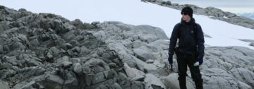
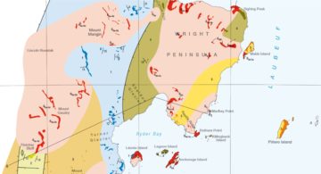
A project to compile over 50 years of geological field data into new geological maps has already seen the publication of six new sheets.
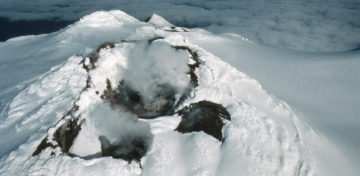
This paper revised the geological history of the Antarctic Peninsula to show how it developed over the last 500 million years, and used this history to tell us about the […]