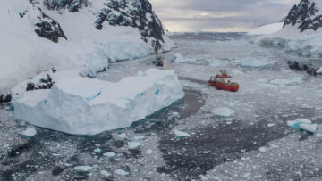
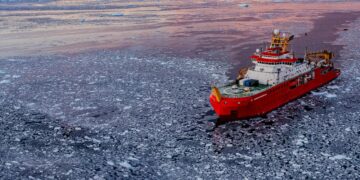
Improving how we measure Antarctic sea ice
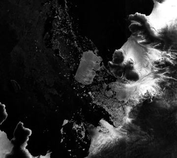
QUASAR uses AI to improve Antarctic sea ice measurements from satellites, making climate data more reliable for scientists tracking changes in polar regions.
I am a machine learning researcher in the Artificial Intelligence (AI) Lab at the British Antarctic Survey (BAS). My research primarily focusses on the application of machine learning techniques to detect features in satellite imagery, including multispectral visible and Synthetic Aperture Radar (SAR) datasets. I have recently trained a convolutional neural network, ViSual_IceD for the detection of sea ice in concurrent mutlispectral and SAR imagery. I am passionate about potential use cases for this work, including as an data source for Autonomous Marine Operations and Planning and for improving information on sea ice conditions for habitat monitoring.
I hold a PhD from the University of Cambridge, where I applied AI techniques, including convolutional neural networks, to automatically detect coastal features and land covers in satellite imagery.
I am also working on the DeepSensor project, using neural processes for cloud infilling of fine resolution multispectral imagery of sea ice conditions.
Rogers, M.S.J, Fox, M., Fleming, A., van Zeeland, L., Wilkinson, J. and Hosking, J.S., 2024. Sea ice detection using concurrent multispectral and synthetic aperture radar imagery. arXiv preprint: https://doi.org/10.48550/arXiv.2401.06009
Bojko, J., Reinke, A.W., Stentiford, G.D., Williams, B., Rogers, M.S.J and Bass, D., 2022. Microsporidia: a new taxonomic, evolutionary, and ecological synthesis. Trends in Parasitology. doi: https://doi.org/10.1016/j.pt.2022.05.007
Rogers, M. S. J., Bithell, M., Brooks, S. M and Spencer, T. 2021. VEdge_Detector: automated coastal vegetation edge detection using a convolutional neural network. International Journal of remote sensing. http://dx.doi.org/10.1080/01431161.2021.1897185
Arundell, K.L., Dubuffet, A., Wedell, N., Bojko, J., Rogers, M.S.J and Dunn, A.M., 2019. Podocotyle atomon (Trematoda: Digenea) impacts reproductive behaviour, survival and physiology in Gammarus zaddachi (Amphipoda). Diseases of aquatic organisms, 136(1), pp.51-62. https://doi.org/10.3354/dao03416
Rogers, M. 2016. Can Structure from Motion determine the efficacy of river re-meandering as a natural flood management measure? Available online: https://www.researchgate.net/profile/Martin_Rogers7
Bowler, E., Byrne, J., Leclerc, L., Roberto-Charron, A., Rogers, M., Cavanagh, R., Harasimo, J., Lancaster, M., Chan, R., Strickson, O., Wilkinson, J., Downie, R., Hosking, J., & Andersson, T. (2025). Pan-Arctic 93-day sea ice concentration forecasts from the IceNet model and mappings between sea ice concentration and Dolphin and Union caribou sea ice crossing-start times (Version 1.0) [Data set]. NERC EDS UK Polar Data Centre. https://doi.org/10.5285/8738b3cb-52c7-4b36-aa6d-6e15c0b46ba4
QUASAR uses AI to improve Antarctic sea ice measurements from satellites, making climate data more reliable for scientists tracking changes in polar regions.
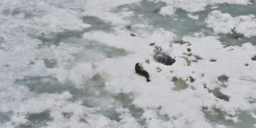
The AI for Earth Observation project develops machine learning tools to detect icebergs, sea ice, and wildlife from satellite imagery.
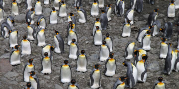
The AI for smart conservation project combines sea ice forecasts, satellite data, and GPS tracking to create early-warning systems for Arctic wildlife.
This project is developing digital twins of Antarctic and Arctic environments and resources. A digital twin makes it possible to test “what if” questions far more quickly than traditional computer models.
IceNet is a deep learning system that forecasts Arctic sea ice. The system is trained on climate simulations and observational data. It outperforms state-of-the-art dynamical models, especially for extreme sea ice events.
AI4EO Accelerator applies artificial intelligence to the large amounts of Earth Observation satellite data now available,