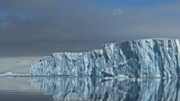
Understanding Greenland’s changing ice
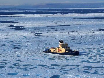
GIANT is a pioneering science project that will test the potential for early warning of a critical climate tipping point.
I am a Marine Geophysicist specialising in Arctic/Antarctic ice-sheet history, glacial geomorphology and glacial/glacial-marine processes. Specifically, I use seafloor DEMs and sub-surface profiles of seafloor sediment layers, often coupled to sediment core records, to reconstruct past ice-sheet behaviour and changing environmental conditions during deglaciation from the last ice age and during Holocene natural variability. I have also worked with remote-sensing data and I enjoy forging links between different disciplines be they observational or more theoretical. My technical specialisms include the acquisition, processing and interpretation of multibeam swath bathymetry, sub-bottom profiler records and shallow marine sediment cores.
Heberlein, Marianne G. Totten, Rebecca L. Fernandez, Rodrigo. Hillenbrand, Claus-Dieter ORCID record for Hillenbrand, Claus-Dieter. Byrne, Colton C. Nitsche, Frank O. Wellner, Julia S. Smith, James A. ORCID record for Smith, James A.. Miller, Lauren E. Radionovskaya, Svetlana. Graham, Alastair G. C. Larter, Robert D. ORCID record for Larter, Robert D.. Hogan, Kelly A. ORCID record for Hogan, Kelly A.. Boehme, Lars. Wacker, Lukas. (2026) Oceanographic influences and high productivity recorded in a coastal bay of the Amundsen Sea, West Antarctica, during the Holocene.
Kostov, Yavor ORCID record for Kostov, Yavor. Holland, Paul R. ORCID record for Holland, Paul R.. Hogan, Kelly A. ORCID record for Hogan, Kelly A.. Smith, James A. ORCID record for Smith, James A.. Jourdain, Nicolas C. ORCID record for Jourdain, Nicolas C.. Mathiot, Pierre. Olivé Abelló, Anna ORCID record for Olivé Abelló, Anna. Fleming, Andrew H. ORCID record for Fleming, Andrew H.. Meijers, Andrew J.S. ORCID record for Meijers, Andrew J.S.. (2026) Modelled dynamics of floating and grounded icebergs, with application to the Amundsen Sea.
Kirkham, James D. ORCID record for Kirkham, James D.. Hogan, Kelly A. ORCID record for Hogan, Kelly A.. Larter, Robert D. ORCID record for Larter, Robert D.. Arnold, Neil S. Self, Ed. Games, Ken. Ely, Jeremy C. Clark, Chris D. Scourse, James D. Shackleton, Calvin. Arndt, Jan Erik. Hillenbrand, Claus-Dieter ORCID record for Hillenbrand, Claus-Dieter. Huuse, Mads. Stewart, Margaret A. Ottesen, Dag. Dowdeswell, Julian A. (2025) Change in iceberg calving behaviour preceded disintegration of North Sea ice shelves during the last deglaciation.
Lehrmann, Asmara A. Totten, Rebecca L. Wellner, Julia S. ORCID record for Wellner, Julia S.. Hillenbrand, Claus-Dieter ORCID record for Hillenbrand, Claus-Dieter. Radionovskaya, Svetlana. Comas, R. Michael. Larter, Robert D. ORCID record for Larter, Robert D.. Graham, Alastair G. C. Kirkham, James D. ORCID record for Kirkham, James D.. Hogan, Kelly A. ORCID record for Hogan, Kelly A.. Fitzgerald, Victoria. Clark, Rachel W. ORCID record for Clark, Rachel W.. Hopkins, Becky. Lepp, Allison P. ORCID record for Lepp, Allison P.. Mawbey, Elaine. Smyth, Rosemary V. Miller, Lauren E. Smith, James A. ORCID record for Smith, James A.. Nitsche, Frank O. ORCID record for Nitsche, Frank O.. (2025) Recent benthic foraminifera communities offshore of Thwaites Glacier in the Amundsen Sea, Antarctica: implications for interpretations of fossil assemblages.
Kirkham, James D. ORCID record for Kirkham, James D.. Hogan, Kelly A. ORCID record for Hogan, Kelly A.. Larter, Robert D. ORCID record for Larter, Robert D.. Self, Ed. Games, Ken. Huuse, Mads. Stewart, Margaret A. Ottesen, Dag. Arnold, Neil S. Dowdeswell, Julian A. (2024) Tunnel valleys as geohazards: new insights from high-resolution 3D seismic data.
Wåhlin, Anna. Alley, Karen E. Begeman, Carolyn. Hegrenæs, Øyvind. Yuan, Xiaohan. Graham, Alastair G.C. Hogan, Kelly ORCID record for Hogan, Kelly. Davis, Peter E.D. ORCID record for Davis, Peter E.D.. Dotto, Tiago S. Eayrs, Clare. Hall, Robert A. Holland, David M. Kim, Tae Wan. Larter, Robert D. ORCID record for Larter, Robert D.. Ling, Li. Muto, Atsuhiro. Pettit, Erin C. Schmidt, Britney E. Snow, Tasha. Stedt, Filip. Washam, Peter M. Wahlgren, Stina. Wild, Christian. Wellner, Julia. Zheng, Yixi. Heywood, Karen J. (2024) Swirls and scoops: Ice base melt revealed by multibeam imagery of an Antarctic ice shelf.
Smith, J.A. ORCID record for Smith, J.A.. Hogan, K.A. ORCID record for Hogan, K.A.. Editors: Elias, Scott (2024) Glaciomarine sediments and processes.
Clark, Rachel W. Wellner, Julia S. Hillenbrand, Claus-Dieter ORCID record for Hillenbrand, Claus-Dieter. Totten, Rebecca L. Smith, James A. ORCID record for Smith, James A.. Miller, Lauren E. Larter, Robert D. ORCID record for Larter, Robert D.. Hogan, Kelly ORCID record for Hogan, Kelly. Graham, Alastair G.C. Nitsche, Frank O. Lehrmann, Asmara A. Lepp, Allison P. Kirkham, James D. ORCID record for Kirkham, James D.. Fitzgerald, Victoria T. Garcia-Barrera, Georgina. Ehrmann, Werner. Wacker, Lukas. (2024) Synchronous retreat of Thwaites and Pine Island glaciers in response to external forcings in the presatellite era.
Kirkham, James D. ORCID record for Kirkham, James D.. Hogan, Kelly A. ORCID record for Hogan, Kelly A.. Larter, Robert D. ORCID record for Larter, Robert D.. Self, Ed. Games, Ken. Huuse, Mads. Stewart, Margaret A. Ottesen, Dag. Le Heron, Daniel P. Lawrence, Alex. Kane, Ian. Arnold, Neil S. Dowdeswell, Julian A. (2023) The infill of tunnel valleys in the central North Sea: Implications for sedimentary processes, geohazards, and ice-sheet dynamics.
Riley, Teal R. ORCID record for Riley, Teal R.. Burton-Johnson, Alex ORCID record for Burton-Johnson, Alex. Hogan, Kelly A. ORCID record for Hogan, Kelly A.. Carter, Andrew. Leat, Philip T. (2023) Cretaceous – Paleogene tectonic reconstructions of the South Scotia Ridge and implications for the initiation of subduction in the Scotia Sea.
Hogan, Kelly A. ORCID record for Hogan, Kelly A.. Warburton, Katarzyna L.P. Graham, Alastair G.C. Neufeld, Jerome A. Hewitt, Duncan R. Dowdeswell, Julian A. Larter, Robert D. ORCID record for Larter, Robert D.. (2022) Towards modelling of corrugation ridges at ice-sheet grounding lines.
Kirkham, James D. ORCID record for Kirkham, James D.. Hogan, Kelly A. ORCID record for Hogan, Kelly A.. Larter, Robert D. ORCID record for Larter, Robert D.. Arnold, Neil S. Ely, Jeremy C. Clark, Chris D. Self, Ed. Games, Ken. Huuse, Mads. Stewart, Margaret A. Ottesen, Dag. Dowdeswell, Julian A. (2022) Tunnel valley formation beneath deglaciating mid-latitude ice sheets: Observations and modelling.
Graham, Alastair G.C. Wåhlin, Anna. Hogan, Kelly A. ORCID record for Hogan, Kelly A.. Nitsche, Frank O. Heywood, Karen J. Totten, Rebecca L. Smith, James A. ORCID record for Smith, James A.. Hillenbrand, Claus-Dieter ORCID record for Hillenbrand, Claus-Dieter. Simkins, Lauren M. Anderson, John B. Wellner, Julia S. Larter, Robert D. ORCID record for Larter, Robert D.. (2022) Rapid retreat of Thwaites Glacier in the pre-satellite era.
Roseby, Zoë A. ORCID record for Roseby, Zoë A.. Smith, James A. ORCID record for Smith, James A.. Hillenbrand, Claus-Dieter ORCID record for Hillenbrand, Claus-Dieter. Cartigny, Matthieu J.B. Rosenheim, Brad E. Hogan, Kelly A. ORCID record for Hogan, Kelly A.. Allen, Claire S. ORCID record for Allen, Claire S.. Leventer, Amy. Kuhn, Gerhard. Ehrmann, Werner. Larter, Robert D. ORCID record for Larter, Robert D.. (2022) History of Anvers-Hugo Trough, western Antarctic Peninsula shelf, since the Last Glacial Maximum. Part I: Deglacial history based on new sedimentological and chronological data.
Riley, Teal R. ORCID record for Riley, Teal R.. Carter, Andrew. Burton-Johnson, Alex ORCID record for Burton-Johnson, Alex. Leat, Philip T. Hogan, Kelly A. ORCID record for Hogan, Kelly A.. Bown, Paul R. (2022) Crustal block origins of the South Scotia Ridge.
Roseby, Zoë A. ORCID record for Roseby, Zoë A.. Smith, James A. ORCID record for Smith, James A.. Hillenbrand, Claus-Dieter ORCID record for Hillenbrand, Claus-Dieter. Allen, Claire S. ORCID record for Allen, Claire S.. Leventer, Amy. Hogan, Kelly ORCID record for Hogan, Kelly. Cartigny, Matthieu J.B. Rosenheim, Brad E. Kuhn, Gerhard. Larter, Robert D. ORCID record for Larter, Robert D.. (2022) History of the Anvers-Hugo Trough, western Antarctic Peninsula shelf, since the Last Glacial Maximum. Part II: Palaeo-productivity and palaeoceanographic changes during the Last Glacial Transition.
Dorschel, Boris. Hehemann, Laura. Viquerat, Sacha. Warnke, Fynn. Dreutter, Simon. Tenberge, Yvonne Schulze. Accetella, Daniela. An, Lu. Barrios, Felipe. Bazhenova, Evgenia. Black, Jenny. Bohoyo, Fernando. Davey, Craig. De Santis, Laura. Dotti, Carlota Escutia. Fremand, Alice C. ORCID record for Fremand, Alice C.. Fretwell, Peter T. ORCID record for Fretwell, Peter T.. Gales, Jenny A. Gao, Jinyao. Gasperini, Luca. Greenbaum, Jamin S. Henderson Jencks, Jennifer. Hogan, Kelly ORCID record for Hogan, Kelly. Hong, Jong Kuk. Jakobsson, Martin. Jensen, Laura. Kool, Johnathan. Larin, Sergei. Larter, Robert D. ORCID record for Larter, Robert D.. Leitchenkov, German. Loubrieu, Benoît. Mackay, Kevin. Mayer, Larry. Millan, Romain. Morlighem, Mathieu. Navidad, Francisco. Nitsche, Frank O. Nogi, Yoshifumi. Pertuisot, Cécile. Post, Alexandra L. Pritchard, Hamish D. ORCID record for Pritchard, Hamish D.. Purser, Autun. Rebesco, Michele. Rignot, Eric. Roberts, Jason L. Rovere, Marzia. Ryzhov, Ivan. Sauli, Chiara. Schmitt, Thierry. Silvano, Alessandro. Smith, Jodie. Snaith, Helen. Tate, Alex J. ORCID record for Tate, Alex J.. Tinto, Kirsty. Vandenbossche, Philippe. Weatherall, Pauline. Wintersteller, Paul. Yang, Chunguo. Zhang, Tao. Arndt, Jan Erik. (2022) The International Bathymetric Chart of the Southern Ocean Version 2.
Lepp, A.P. Simkins, L.M. Anderson, J.B. Clark, R.W. Wellner, J.S. Hillenbrand, C.-D. ORCID record for Hillenbrand, C.-D.. Smith, J.A. ORCID record for Smith, J.A.. Lehrmann, A.A. Totten, R. Larter, R.D. ORCID record for Larter, R.D.. Hogan, K.A. ORCID record for Hogan, K.A.. Nitsche, F.O. Graham, A.G.C. Wacker, L. (2022) Sedimentary Signatures of Persistent Subglacial Meltwater Drainage From Thwaites Glacier, Antarctica.
Jennings, Anne. Reilly, Brendan. Andrews, John. Hogan, Kelly ORCID record for Hogan, Kelly. Walczak, Maureen. Jakobsson, Martin. Stoner, Joseph. Mix, Alan. Nicholls, Keith W. ORCID record for Nicholls, Keith W.. O'Regan, Matt. Prins, Maarten A. Troelstra, Simon R. (2022) Modern and early Holocene ice shelf sediment facies from Petermann Fjord and northern Nares Strait, northwest Greenland.
Hogan, K.A. ORCID record for Hogan, K.A.. Arnold, N.S. Larter, R.D. ORCID record for Larter, R.D.. Kirkham, J.D. ORCID record for Kirkham, J.D.. Noormets, R. Ó Cofaigh, C. Golledge, N. Dowdeswell, J.A. (2022) Subglacial water flow over an Antarctic palaeo-ice stream bed.
Kirkham, James D. ORCID record for Kirkham, James D.. Hogan, Kelly A. ORCID record for Hogan, Kelly A.. Larter, Robert D. ORCID record for Larter, Robert D.. Self, Ed. Games, Ken. Huuse, Mads. Stewart, Margaret A. Ottesen, Dag. Arnold, Neil S. Dowdeswell, Julian A. (2021) Tunnel valley infill and genesis revealed by high-resolution 3-D seismic data.
Riley, Teal R. ORCID record for Riley, Teal R.. Burton-Johnson, Alex ORCID record for Burton-Johnson, Alex. Leat, Philip T. Hogan, Kelly A. ORCID record for Hogan, Kelly A.. Halton, Alison M. (2021) Geochronology and geochemistry of the South Scotia Ridge: Miocene island arc volcanism of the Scotia Sea.
Pieńkowski, A.J. Husum, K. Belt, S.T. Ninneman, U. Köseoğlu, D. Divine, D.V. Smik, L. Knies, J. Hogan, K. ORCID record for Hogan, K.. Noormets, R. (2021) Seasonal sea ice persists through the Holocene Thermal Maximum at 80°N.
Wåhlin, A.K. Graham, A.G.C. Hogan, K.A. ORCID record for Hogan, K.A.. Queste, B.Y. Boehme, L. Larter, R.D. ORCID record for Larter, R.D.. Pettit, E.C. Wellner, J. Heywood, K.J. (2021) Pathways and modification of warm water flowing beneath Thwaites Ice Shelf, West Antarctica.
Hogan, Kelly A. ORCID record for Hogan, Kelly A.. Larter, Robert D. ORCID record for Larter, Robert D.. Graham, Alastair G.C. Arthern, Robert ORCID record for Arthern, Robert. Kirkham, James D. ORCID record for Kirkham, James D.. Totten Minzoni, Rebecca. Jordan, Tom A. ORCID record for Jordan, Tom A.. Clark, Rachel. Fitzgerald, Victoria. Wåhlin, Anna K. Anderson, John B. Hillenbrand, Claus-Dieter ORCID record for Hillenbrand, Claus-Dieter. Nitsche, Frank O. Simkins, Lauren. Smith, James ORCID record for Smith, James. Gohl, Karsten. Arndt, Jan Erik. Hong, Jongkuk. Wellner, Julia. (2020) Revealing the former bed of Thwaites Glacier using sea-floor bathymetry: implications for warm-water routing and bed controls on ice flow and buttressing.
Kirkham, James D. ORCID record for Kirkham, James D.. Hogan, Kelly A. ORCID record for Hogan, Kelly A.. Larter, Robert D. ORCID record for Larter, Robert D.. Arnold, Neil S. Nitsche, Frank O. Kuhn, Gerhard. Gohl, Karsten. Anderson, John B. Dowdeswell, Julian A. (2020) Morphometry of bedrock meltwater channels on Antarctic inner continental shelves.
Jordan, Tom A. ORCID record for Jordan, Tom A.. Porter, David. Tinto, Kirsty. Millan, Romain. Muto, Atsuhiro. Hogan, Kelly ORCID record for Hogan, Kelly. Larter, Robert D. ORCID record for Larter, Robert D.. Graham, Alastair G.C. Paden, John D. (2020) New gravity-derived bathymetry for the Thwaites, Crosson and Dotson ice shelves revealing two ice shelf populations.
Hogan, Kelly A. ORCID record for Hogan, Kelly A.. Jakobsson, Martin. Mayer, Larry. Reilly, Brendan T. Jennings, Anne E. Stoner, Joseph S. Nielsen, Tove. Andresen, Katrine J. Nørmark, Egon. Heirman, Katrien A. Kamla, Elina. Jerram, Kevin. Stranne, Christian. Mix, Alan. (2020) Glacial sedimentation, fluxes and erosion rates associated with ice retreat in Petermann Fjord and Nares Strait, north-west Greenland.
Kirkham, James D. ORCID record for Kirkham, James D.. Hogan, Kelly A. ORCID record for Hogan, Kelly A.. Larter, Robert D. ORCID record for Larter, Robert D.. Arnold, Neil S. Nitsche, Frank O. Golledge, Nicholas R. Dowdeswell, Julian A. (2019) Past water flow beneath Pine Island and Thwaites glaciers, West Antarctica.
Reilly, Brendan T. Stoner, Joseph S. Mix, Alan C. Walczak, Maureen H. Jennings, Anne. Jakobsson, Martin. Dyke, Laurence. Glueder, Anna. Nicholls, Keith ORCID record for Nicholls, Keith. Hogan, Kelly A. ORCID record for Hogan, Kelly A.. Mayer, Larry A. Hatfield, Robert G. Albert, Sam. Marcott, Shaun. Fallon, Stewart. Cheseby, Maziet. (2019) Holocene break-up and reestablishment of the Petermann Ice Tongue, Northwest Greenland.
Larter, Robert D. ORCID record for Larter, Robert D.. Hogan, Kelly A. ORCID record for Hogan, Kelly A.. Hillenbrand, Claus-Dieter ORCID record for Hillenbrand, Claus-Dieter. Smith, James A. ORCID record for Smith, James A.. Batchelor, Christine L. Cartigny, Matthieu. Tate, Alex J. ORCID record for Tate, Alex J.. Kirkham, James D. ORCID record for Kirkham, James D.. Roseby, Zoë A. ORCID record for Roseby, Zoë A.. Kuhn, Gerhard. Graham, Alastair G.C. Dowdeswell, Julian A. (2019) Subglacial hydrological control on flow of an Antarctic Peninsula palaeo-ice stream.
Batchelor, C.L. Dowdeswell, J.A. Hogan, Kelly A. ORCID record for Hogan, Kelly A.. Larter, Robert D. ORCID record for Larter, Robert D.. Parsons, E. West, O. (2019) Processes and patterns of glacier-influenced sedimentation and recent tidewater glacier dynamics in Darbel Bay, western Antarctic Peninsula.
Lomac-MacNair, Kate. Jakobsson, Martin. Mix, Alan. Freire, Francis. Hogan, Kelly ORCID record for Hogan, Kelly. Mayer, Larry. Smultea, Mari A. (2019) Seal occurrence and habitat use during summer in Petermann Fjord, northwestern Greenland.
Le Heron, D.P. Hogan, K.A. ORCID record for Hogan, K.A.. Phillips, E.R. Huuse, M. Busfield, M.E. Graham, A.G.C. Editors: Le Heron, D.P. Hogan, K.A. ORCID record for Hogan, K.A.. Phillips, E.R. Huuse, M. Busfield, M.E. Graham, A.G.C (2019) An introduction to glaciated margins: the sedimentary and geophysical archive.
Hodgson, Dominic ORCID record for Hodgson, Dominic. Jordan, Tom ORCID record for Jordan, Tom. De Rydt, Jan. Fretwell, Peter ORCID record for Fretwell, Peter. Seddon, Samuel. Becker, David. Hogan, Kelly ORCID record for Hogan, Kelly. Smith, Andy ORCID record for Smith, Andy. Vaughan, David ORCID record for Vaughan, David. (2019) Past and future dynamics of the Brunt Ice Shelf from seabed bathymetry and ice shelf geometry.
Dowdeswell, J.A. Hogan, Kelly A. ORCID record for Hogan, Kelly A.. Le Heron, D. P. (2019) The glacier-influenced marine record on high-latitude continental margins: synergies between modern, Quaternary and ancient evidence.
Wangner, David J. Jennings, Anne E. Vermassen, Flor. Dyke, Laurence M. Hogan, Kelly A. ORCID record for Hogan, Kelly A.. Schmidt, Sabine. Kjær, Kurt H. Knudsen, Mads F. Andresen, Camilla S. (2018) A 2000-year record of ocean influence on Jakobshavn Isbræ calving activity, based on marine sediment cores.
Jakobsson, Martin. Hogan, Kelly A. ORCID record for Hogan, Kelly A.. Mayer, Larry A. Mix, Alan. Jennings, Anne. Stoner, Joe. Eriksson, Bjorn. Jerram, Kevin. Mohammad, Rezwan. Pearce, Christof. Reilly, Brendan. Stranne, Christian. (2018) The Holocene retreat dynamics and stability of Petermann Glacier in northwest Greenland.
Hodgson, Dominic A. ORCID record for Hodgson, Dominic A.. Hogan, Kelly ORCID record for Hogan, Kelly. Smith, James M. Smith, James A. ORCID record for Smith, James A.. Hillenbrand, Claus-Dieter ORCID record for Hillenbrand, Claus-Dieter. Graham, Alistair G.C. Fretwell, Peter ORCID record for Fretwell, Peter. Allen, Claire ORCID record for Allen, Claire. Peck, Vicky ORCID record for Peck, Vicky. Arndt, Jan-Erik. Dorschel, Boris. Hübscher, Christian. Smith, Andy M. ORCID record for Smith, Andy M.. Larter, Robert ORCID record for Larter, Robert. (2018) Deglaciation and future stability of the Coats Land ice margin, Antarctica.
Ó Cofaigh, Colm. Hogan, Kelly A. ORCID record for Hogan, Kelly A.. Jennings, Anne E. Callard, S. Louise. Dowdeswell, Julian A. Noormets, Riko. Evans, Jeff. (2018) The role of meltwater in high-latitude trough-mouth fan development: the Disko Trough-Mouth Fan, West Greenland.
Morlighem, M. Williams, C. N. Rignot, E. An, L. Arndt, J. E. Bamber, J. L. Catania, G. Chauché, N. Dowdeswell, J. A. Dorschel, B. Fenty, I. Hogan, Kelly ORCID record for Hogan, Kelly. Howat, I. Hubbard, A. Jakobsson, M. Jordan, T. M. Kjeldsen, K. K. Millan, R. Mayer, L. Mouginot, J. Noël, B. P. Y. O'Cofaigh, C. Palmer, S. Rysgaard, S. Seroussi, H. Siegert, M. J. Slabon, P. Straneo, F. van den Broeke, M. R. Weinrebe, W. Wood, M. Zinglersen, K. B. (2018) BedMachine v3: Complete Bed Topography and Ocean Bathymetry Mapping of Greenland From Multibeam Echo Sounding Combined With Mass Conservation.
Fransner, O. Noormets, R. Flink, A.E. Hogan, K.A. ORCID record for Hogan, K.A.. Dowdeswell, J.A. (2017) Sedimentary processes on the continental slope off Kvitøya and Albertini troughs north of Nordaustlandet, Svalbard – The importance of structural-geological setting in trough-mouth fan development.
Spagnolo, Matteo. Bartholomaus, Timothy C. Clark, Chris D. Stokes, Chris R. Atkinson, Nigel. Dowdeswell, Julian A. Ely, Jeremy C. Graham, Alistair G.C. Hogan, Kelly A. ORCID record for Hogan, Kelly A.. King, Edward C. ORCID record for King, Edward C.. Larter, Robert D. ORCID record for Larter, Robert D.. Livingstone, Stephen J. Pritchard, Hamish D. ORCID record for Pritchard, Hamish D.. (2017) The periodic topography of ice stream beds: insights from the Fourier spectra of mega-scale glacial lineations.
Flink, Anne E. Noormets, Riko. Fransner, Oscar. Hogan, Kelly A. ORCID record for Hogan, Kelly A.. ÓRegan, Matthew. Jakobsson, Martin. (2017) Past ice flow in Wahlenbergfjorden and its implications for late Quaternary ice sheet dynamics in northeastern Svalbard.
Streuff, Katharina. Ó Cofaigh, Colm. Hogan, Kelly ORCID record for Hogan, Kelly. Jennings, Anne. Lloyd, Jeremy M. Noormets, Riko. Nielsen, Tove. Kuijpers, Antoon. Dowdeswell, Julian A. Weinrebe, Wilhelm. (2017) Seafloor geomorphology and glacimarine sedimentation associated with fast-flowing ice sheet outlet glaciers in Disko Bay, West Greenland.
Hogan, Kelly A. ORCID record for Hogan, Kelly A.. Dowdeswell, Julian A. Hillenbrand, Claus-Dieter ORCID record for Hillenbrand, Claus-Dieter. Ehrmann, Werner. Noormets, Riko. Wacker, Lukas. (2017) Subglacial sediment pathways and deglacial chronology of the northern Barents Sea Ice Sheet.
Fransner, O. Noormets, R. Flink, A. E. Hogan, K. A. ORCID record for Hogan, K. A.. O'Regan, M. Jakobsson, M. (2017) Glacial landforms and their implications for glacier dynamics in Rijpfjorden and Duvefjorden, northern Nordaustlandet, Svalbard.
Bell, T. Cooper, A. K. Solheim, A. Todd, B. J. Dowdeswell, J. A. Canals, M. Jakobsson, M. Dowdeswell, E. K. Hogan, K. A. ORCID record for Hogan, K. A.. Editors: Dowdeswell, J.A. Canals, M. Jakobsson, M. Todd, B.J. Dowdeswell, E.K. Hogan, K.A. ORCID record for Hogan, K.A. (2017) Glossary of glaciated continental margins and related geoscience methods.
Dowdeswell, J. A. Canals, M. Jakobsson, M. Todd, B. J. Dowdeswell, E. K. Hogan, K. A. ORCID record for Hogan, K. A.. Editors: Dowdeswell, J.A. Canals, M. Jakobsson, M. Todd, B.J. Dowdeswell, E.K. Hogan, K.A. ORCID record for Hogan, K.A. (2017) The variety and distribution of submarine glacial landforms and implications for ice-sheet reconstruction.
Livingstone, S. J. O Cofaigh, C. Hogan, K. A. ORCID record for Hogan, K. A.. Dowdeswell, J. A. Editors: Dowdeswell, J.A. Canals, M. Jakobsson, M. Todd, B.J. Dowdeswell, E.K. Hogan, K.A. ORCID record for Hogan, K.A. (2017) Submarine glacial-landform distribution along an Antarctic Peninsula palaeo-ice stream: a shelf-slope transect through the Marguerite Trough system (66-70 S).
Garcia, M. Batchelor, C. L. Dowdeswell, J. A. Hogan, K. A. ORCID record for Hogan, K. A.. O Cofaigh, C. Editors: Dowdeswell, J.A. Canals, M. Jakobsson, M. Todd, B.J. Dowdeswell, E.K. Hogan, K.A. ORCID record for Hogan, K.A. (2017) A glacier-influenced turbidite system and associated landform assemblage in the Greenland Basin and adjacent continental slope.
Dowdeswell, J. A. Hogan, K. A. ORCID record for Hogan, K. A.. O Cofaigh, C. Editors: Dowdeswell, J.A. Canals, M. Jakobsson, M. Todd, B.J. Dowdeswell, E.K. Hogan, K.A. ORCID record for Hogan, K.A. (2017) Submarine glacial-landform distribution across the West Greenland margin: a fjord-shelf-slope transect through the Uummannaq system (70-71 N).
Hogan, K. A. ORCID record for Hogan, K. A.. Vanneste, M. Dowdeswell, J. A. Mienert, J. Editors: Dowdeswell, J.A. Canals, M. Jakobsson, M. Todd, B.J. Dowdeswell, E.K. Hogan, K.A. ORCID record for Hogan, K.A. (2017) Geomorphology of the huge Hinlopen-Yermak landslide on the northern Svalbard margin.
Larter, R.D. ORCID record for Larter, R.D.. Hogan, K.A. ORCID record for Hogan, K.A.. Dowdeswell, J.A. Editors: Dowdeswell, J.A. Canals, M. Jakobsson, M. Todd, B.J. Dowdeswell, E.K. Hogan, K.A. ORCID record for Hogan, K.A. (2017) Large sediment drifts on the upper continental rise west of the Antarctic Peninsula.
Larter, R.D. ORCID record for Larter, R.D.. Hogan, K.A. ORCID record for Hogan, K.A.. Hillenbrand, C.-D. ORCID record for Hillenbrand, C.-D.. Benetti, S. Editors: Dowdeswell, J.A. Canals, M. Jakobsson, M. Todd, B.J. Dowdeswell, E.K. Hogan, K.A. ORCID record for Hogan, K.A. (2017) Debris-flow deposits on the West Antarctic continental slope.
Hogan, Kelly A. ORCID record for Hogan, Kelly A.. Dowdeswell, J. A. Noormets, R. Editors: Dowdeswell, J.A. Canals, M. Jakobsson, M. Todd, B.J. Dowdeswell, E.K. Hogan, K.A. ORCID record for Hogan, K.A. (2017) Assemblages of submarine landforms in the glacial troughs of the northern Barents Sea, east of Svalbard.
Batchelor, C. L. Dowdeswell, J. A. Jakobsson, M. Hogan, Kelly A. ORCID record for Hogan, Kelly A.. Gebhardt, C. A. Editors: Dowdeswell, J.A. Canals, M. Jakobsson, M. Todd, B.J. Dowdeswell, E.K. Hogan, K.A. ORCID record for Hogan, K.A. (2017) Landform assemblage produced by ice-grounding events on the Yermak Plateau.
Dowdeswell, J. A. Hogan, Kelly A. ORCID record for Hogan, Kelly A.. Editors: Dowdeswell, J.A. Canals, M. Jakobsson, M. Todd, B.J. Dowdeswell, E.K. Hogan, K.A. ORCID record for Hogan, K.A. (2017) Huge iceberg ploughmarks and associated corrugation ridges on the northern Svalbard shelf.
Evans, J. Hogan, Kelly A. ORCID record for Hogan, Kelly A.. Editors: Dowdeswell, J.A. Canals, M. Jakobsson, M. Todd, B.J. Dowdeswell, E.K. Hogan, K.A. ORCID record for Hogan, K.A. (2017) Grounding-zone wedges on the northern Larsen shelf, Antarctic Peninsula.
Graham, A. G. C. Hogan, Kelly A. ORCID record for Hogan, Kelly A.. Editors: Dowdeswell, J.A. Canals, M. Jakobsson, M. Todd, B.J. Dowdeswell, E.K. Hogan, K.A (2017) Crescentic scours on palaeo-ice stream beds.
Hogan, K.A. ORCID record for Hogan, K.A.. Dowdeswell, J.A. Larter, R.D. ORCID record for Larter, R.D.. O Cofaigh, C. Bartholemew, I. Editors: Dowdeswell, J.A. Canals, M. Jakobsson, M. Todd, B.J. Dowdeswell, E.K. Hogan, K. ORCID record for Hogan, K. (2017) Subglacial meltwater channels in Marguerite Trough, western Antarctic Peninsula.
Ryan, J.C. Dowdeswell, J.A. Hogan, K.A. ORCID record for Hogan, K.A.. Editors: Dowdeswell, J.A. Canals, M. Jakobsson, M. Todd, B.J. Dowdeswell, E.K. Hogan, K.A (2017) Three cross-shelf troughs on the continental shelf of SW Greenland from Olex data.
Ó Cofaigh, C. Hogan, K.A. ORCID record for Hogan, K.A.. Dowdeswell, J.A. Streuff, K. Editors: Dowdeswell, J.A. Canals, M. Jakobsson, M. Todd, B.J. Dowdeswell, E.K. Hogan, K.A (2017) Stratified glacimarine basin-fills in West Greenland fjords.
Burton, D.J. Dowdeswell, J.A. Hogan, K.A. ORCID record for Hogan, K.A.. Noormets, R. Editors: Dowdeswell, J.A. Canals, M. Jakobsson, M. Todd, B.J. Dowdeswell, E.K. Hogan, K.A (2017) Little Ice Age terminal and retreat moraines in Kollerfjorden, NW Spitsbergen.
Fransner, O. Noormets, R. Flink, A.E. Hogan, K.A. ORCID record for Hogan, K.A.. Editors: Dowdeswell, J.A. Canals, M. Jakobsson, M. Todd, B.J. Dowdeswell, E.K. Hogan, K.A (2017) Crag-and-tail landforms in outer Rijpfjorden, Nordaustlandet, Svalbard.
Dowdeswell, J.A. Batchelor, C.L. Hogan, K.A. ORCID record for Hogan, K.A.. Schenke, H.-W. Editors: Dowdeswell, J.A. Canals, M. Jakobsson, M. Todd, B.J. Dowdeswell, E.K. Hogan, K.A (2017) Nordvestfjord: a major East Greenland fjord system.
Jakobsson, M. Gyllencreutz, R. Mayer, L.A. Dowdeswell, J.A. Canals, M. Todd, B.J. Dowdeswell, E.K. Hogan, K.A. ORCID record for Hogan, K.A.. Larter, R.D. ORCID record for Larter, R.D.. Editors: Dowdeswell, J.A. Canals, M. Jakobsson, M. Todd, B.J. Dowdeswell, E.K. Hogan, K.A (2017) Mapping submarine glacial landforms using acoustic methods.
Dowdeswell, J. A. Canals, M. Jakobsson, M. Todd, B. J. Dowdeswell, E. K. Hogan, K. A. ORCID record for Hogan, K. A.. Editors: Dowdeswell, J.A. Canals, M. Jakobsson, M. Todd, B.J. Dowdeswell, E.K. Hogan, K.A. ORCID record for Hogan, K.A. (2017) Introduction: an atlas of submarine glacial landforms.
García, Marga. Dowdeswell, J.A. Noormets, R. Hogan, K.A. ORCID record for Hogan, K.A.. Evans, J. Ó Cofaigh, C. Larter, R.D. ORCID record for Larter, R.D.. (2016) Geomorphic and shallow-acoustic investigation of an Antarctic Peninsula fjord system using high-resolution ROV and shipboard geophysical observations: Ice dynamics and behaviour since the Last Glacial Maximum.
White, Lee F. Bailey, Ian. Foster, Gavin L. Allen, Georgina. Kelley, Simon P. Andrews, John T. Hogan, Kelly ORCID record for Hogan, Kelly. Dowdeswell, Julian A. Storey, Craig D. (2016) Tracking the provenance of Greenland-sourced, Holocene aged, individual sand-sized ice-rafted debris using the Pb-isotope compositions of feldspars and 40Ar/39Ar ages of hornblendes.
Burton, David J. Dowdeswell, Julian A. Hogan, Kelly A. ORCID record for Hogan, Kelly A.. Noormets, Riko. (2016) Marginal fluctuations of a Svalbard surge-type tidewater glacier, Bloomstrandbreen, since the little ice age: a record of three surges.
Sheldon, Christina. Jennings, Anne. Andrews, John T. Ó Cofaigh, Colm. Hogan, Kelly ORCID record for Hogan, Kelly. Dowdeswell, Julian A. Seidenkrantz, Marit-Solveig. (2016) Ice stream retreat following the LGM and onset of the west Greenland current in Uummannaq Trough, west Greenland.
Hogan, Kelly A. ORCID record for Hogan, Kelly A.. O Cofaigh, Colm. Jennings, Anne E. Dowdeswell, Julian A. Hiemstra, John F. (2016) Deglaciation of a major palaeo-ice stream in Disko Trough, West Greenland.
Hillier, J.K. Smith, M.J. Armugam, R. Barr, I. Boston, C.M. Clark, C.D. Ely, J. Fankl, A. Greenwood, S.L. Gosselin, L. Hättestrand, C. Hogan, K. ORCID record for Hogan, K.. Hughes, A.L.C. Livingstone, S.J. Lovell, H. McHenry, M. Munoz, Y. Pellicer, X.M. Pellitero, R. Robb, C. Roberson, S. Ruther, D. Spagnolo, M. Standell, M. Stokes, C.R. Storrar, R. Tate, N.J. Wooldridge, K. (2015) Manual mapping of drumlins in synthetic landscapes to assess operator effectiveness.
Hogan, K., O’Cofaigh, C., Howe, J., Roberts, D., Donate, V., Fremand, A., Hunt, M., Jenkins, H., Larter, R., Metcalfe, J., & Strandlod, F. (2026). Sub-bottom profile data collected from a hull-mounted Kongsberg Marine TOPAS (PS18) profiler during RRS Sir David Attenborough SD041 cruise, 2024 (Version 1.0) [Data set]. NERC EDS UK Polar Data Centre. https://doi.org/10.5285/73f50a04-0a2a-4e69-bb4e-ee6fffa4c026
Howe, J., Drysdale, L., Hogan, K., O’Cofaigh, C., Castro de la Guardia, L., Donate, V., Fremand, A., Riehn, L., & Larter, R. (2026). Raw bathymetry data collected from a Kongsberg EM2040 multibeam echosounder installed on the workboat Erebus during RRS Sir David Attenborough SD041 cruise, 2024 (Version 1.0) [Data set]. NERC EDS UK Polar Data Centre. https://doi.org/10.5285/83c5b315-2890-436b-b596-5d48bc9dbe47
O’Cofaigh, C., Hogan, K., Howe, J., Roberts, D., Donate, V., Fremand, A., Hunt, M., Jenkins, H., Larter, R., Metcalfe, J., & Strandlod, F. (2026). Raw bathymetry data collected from a hull-mounted Kongsberg EM712 multibeam echosounder during RRS Sir David Attenborough SD041 cruise, 2024 (Version 1.0) [Data set]. NERC EDS UK Polar Data Centre. https://doi.org/10.5285/9929e59b-eff5-4add-ab51-9ca6138e677d
Inall, M., Muchowski, J., Stedt, F., Atherden, F., Murphy, A., Hogan, K., & O’Cofaigh, C. (2026). Raw bathymetry data collected from a hull-mounted Kongsberg EM2040 multibeam echosounder during RV Skagerak SK2514 cruise, 2025 (Version 1.0) [Data set]. NERC EDS UK Polar Data Centre. https://doi.org/10.5285/543cbcd8-4e2c-4927-a91e-52d42e75cfb4
O’Cofaigh, C., Hogan, K., Howe, J., Roberts, D., Donate, V., Fremand, A., Hunt, M., Jenkins, H., Larter, R., Metcalfe, J., & Strandlod, F. (2026). Raw bathymetry data collected from a hull-mounted Kongsberg EM122 multibeam echosounder during RRS Sir David Attenborough SD041 cruise, 2024 (Version 1.0) [Data set]. NERC EDS UK Polar Data Centre. https://doi.org/10.5285/9b14a4ee-96ad-4520-97d7-3b3b2821ab74
Jordan, T., Heywood, K., Wahlin, A., Hall, R., Muto, A., Dutrieux, P., Hogan, K., Girton, J., Alley, K., & Pettit, E. (2025). Updated gravity-derived bathymetry for the Thwaites, Crosson and Dotson ice shelves (2009-2022) (Version 1.0) [Data set]. NERC EDS UK Polar Data Centre. https://doi.org/10.5285/baef2e88-300f-42bc-8ccb-bfdff147a492
Larter, R., Hogan, K., Hillenbrand, C., & Gowland, E. (2021). Topographic Parametric Sonar (TOPAS) acoustic sub-bottom profiler data acquired on RRS James Clark Ross JR298 cruise in 2015 (Version 1.0) [Data set]. NERC EDS UK Polar Data Centre. https://doi.org/10.5285/bdfeb69c-df5c-461d-b7a8-583f9daab685
Dowdeswell, J., Larter, R., Noormets, R., Griffiths, G., & Hogan, K. (2021). Isis remotely-operated vehicle (ROV) bathymetry data in Marguerite Trough, Antarctica, from James Clark Ross cruise JR157, 2007 (Version 1.0) [Data set]. NERC EDS UK Polar Data Centre. https://doi.org/10.5285/ef1996e4-7825-4456-b1f7-4d1b26531d72
Jordan, T., Porter, D., Tinto, K., Millan, R., Muto, A., Hogan, K., Larter, R., Graham, A., Paden, J., & Robinson, C. (2020). Gravity-derived bathymetry for the Thwaites, Crosson and Dotson ice shelves (2009-2019) (Version 1.0) [Data set]. UK Polar Data Centre, Natural Environment Research Council, UK Research & Innovation. https://doi.org/10.5285/7803de8b-8a74-466b-888e-e8c737bf21ce
Hogan, K., Larter, R., Graham, A., Nitsche, F., Kirkham, J., Totten Minzoni, R., Clark, R., Fitzgerald, V., Anderson, J., Hillenbrand, C., Simkins, L., Smith, J., Gohl, K., Arndt, J., Hong, J., Heywood, K., Abrahamsen, E., Thompson, A., Dunbar, R., & Wellner, J. (2020). A multibeam-bathymetric compilation for the southern Amundsen Sea shelf, 1999-2019 (Version 1.0) [Data set]. UK Polar Data Centre, Natural Environment Research Council, UK Research & Innovation. https://doi.org/10.5285/f2dfeda9-bf44-4ef5-89a3-ee5e434a385c
Hodgson, D., Jordan, T., de Rydt, J., Fretwell, P., Seddon, S., Becker, D., Hogan, K., Smith, A., & Vaughan, D. (2019). Gravity enhanced bathymetric model beneath the Brunt Ice Shelf and Stancomb-Wills Glacier Tongue (Version 1) [Data set]. UK Polar Data Centre, Natural Environment Research Council, UK Research & Innovation. https://doi.org/10.5285/40bcedbe-fea0-4b41-b2f7-bf2d8494b5ad
Larter, R., Hogan, K., Hillenbrand, C., Smith, J., Batchelor, C., Cartigny, M., Tate, A., Kirkham, J., Roseby, Z., Kuhn, G., Graham, A., & Dowdeswell, J. (2019). A bathymetric compilation over Anvers-Hugo Trough, Perrier Trough and Palmer Deep, 1990-2017 (Version 1.0) [Data set]. UK Polar Data Centre, Natural Environment Research Council, UK Research & Innovation. https://doi.org/10.5285/70905d9c-6dc0-421b-b20b-1e2dff97e802
Fretwell, P., Hodgson, D., Hogan, K., Smith, J., Hillenbrand, C., Allen, C., Peck, V., Arndt, J., Dorschel, B., Hubscher, C., Smith, A., Larter, R., & Graham, A. (2019). A bathymetric compilation of the Brunt Sub-Iceshelf, Antarctica (Version 1.0) [Data set]. NERC EDS UK Polar Data Centre. https://data.bas.ac.uk/full-record.php?id=GB/NERC/BAS/PDC/01134
GIANT is a pioneering science project that will test the potential for early warning of a critical climate tipping point.
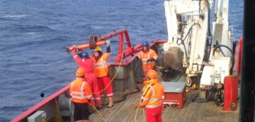
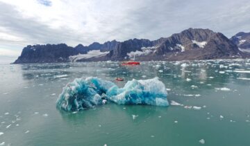
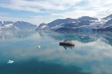
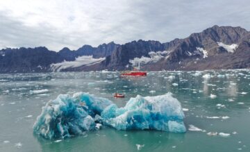
KANG-GLAC studies past and present glacier-ocean changes in southeast Greenland to predict how ice loss will affect ocean circulation, ecosystems and climate.
THOR examined sedimentary record both offshore from the glacier and beneath the ice shelf, together with glacial landforms on the sea bed, to reconstruct past changes in ocean conditions and the glaciers response to these changes.
The International Thwaites Glacier Collaboration unites global scientists to study Antarctica’s most vulnerable glacier, predict sea-level rise, and inform climate action worldwide.
This project will tackle the the question of how strongly changes in ocean circulation affect global climate.
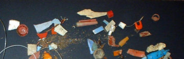
This project investigated plastic pollution across Arctic and Antarctic environments. Scientists collected water, ice, and sediment samples to quantify macro and microplastic pollution, track its sources, and assess its impact on polar wildlife.
This research focuses on investigating the glacial histories of Arctic ice sheets and ice caps using the marine geological record preserved on continental margins.
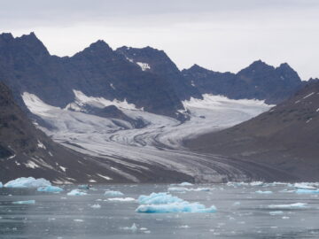
A scientist’s view from Petermann Fjord, NW Greenland Three-and-a-bit days is what it takes to get from London to Thule air base in northwest Greenland. A quick flight to Copenhagen […]
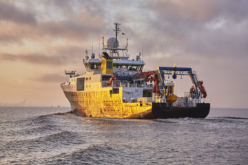
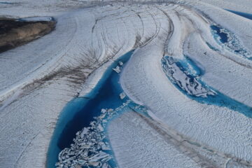
An international team is collecting observations to understand how a melting Greenland is affecting ocean currents, which could cause weather change in UK and Europe
An international team of scientists is heading to Greenland this summer for a two-month expedition to discover how quickly the ice sheet’s rapidly melting glaciers are pushing the Atlantic Ocean towards a critical climate tipping point.
British Antarctic Survey (BAS) researchers have been selected for funding from The Advanced Research + Invention Agency (ARIA) to help improve our understanding of climate tipping points.
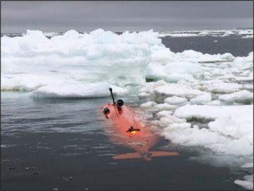
An international research team deployed the uncrewed submersible ‘Ran’ underneath 350 m thick ice. They got back the very first detailed maps covering extensive areas of the underside of a glacier, revealing clues to future sea level rise.
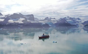
A team will work in south-east Greenland to advance our understanding of the region’s rapidly decaying ice sheet and its impacts on ocean and global climate systems.
Are you interested in getting an up to 40 m long marine sediment core for either high-resolution Holocene or Late Quaternary reconstructions? If so, join our workshop!
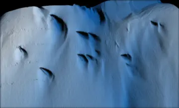
Deep valleys buried under the seafloor of the North Sea record how the ancient ice sheets that used to cover the UK and Europe expelled water to stop themselves from […]
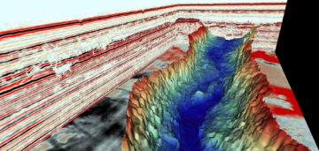
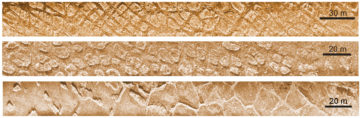
Spectacular ice age landscapes beneath the North Sea have been discovered using 3D seismic reflection technology. Similar to MRI (magnetic resonance imaging) the images reveal in unprecedented detail huge seafloor […]

For the first time, researchers have collected data from underneath the remote Thwaites Glacier in West Antarctica using an underwater robot.
On International Women’s Day (8 March 2021), we mark and celebrate women working at British Antarctic Survey (BAS). We showcase the diversity of roles and specialities of those working in […]
Calling all schools, home-schoolers and anyone interested in polar science! We are delighted to bring you the Antarctica Week Festival 2020 giving you an opportunity to hear the stories of […]
Newly discovered deep seabed channels beneath Thwaites Glacier in West Antarctica may be the pathway for warm ocean water to melt the underside of the ice. Data from two research […]
The most comprehensive and high-resolution atlas of the seafloor of both Polar Regions is presented this week (Tuesday 25 April) at the European Geosciences Union General Assembly (EGU) in Vienna.
Exploring the seafloor