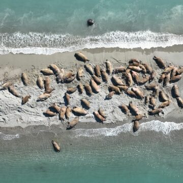
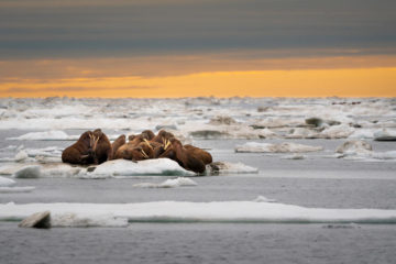
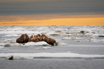
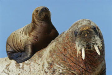
Counting Walruses from Space
Despite their importance to Arctic ecosystems, we don’t know how many walruses exist. We’re using satellite images and citizen science to count walruses.
My research interests are to develop the use of space technology for marine wildlife research in remote places, and make this method applicable at a global oceanic scale by improving the efficiency of image analysis through crowdsourcing and automated systems.
SmartWhales: Data from space to help protect the endangered North Atlantic right whale (Government of Canada) – Ongoing
Wintering whales of the Western Antarctic Peninsula (WWF project) – Ongoing
Pelagos – Ship strike: Proposal to develop and evaluate mitigation strategies to reduce the risk of ship strikes to fin and sperm whales in the Pelagos Sanctuary (Pelagos) – Completed
ECOPOTENTIAL: Improving future ecosystem benefits through earth observations (H2020 project) – Completed
EO4wildlife: Protection and conservation of wildlife, platform for wildlife monitoring integrating Copernicus and ARGOS data (H2020 project) – Completed
Cubaynes, Hannah C. ORCID record for Cubaynes, Hannah C.. Vergara-Pena, Alejandra. Bowler, Ellen ORCID record for Bowler, Ellen. Downie, Rod. Forcada, Jaume ORCID record for Forcada, Jaume. Garde, Eva. Heide-Jørgensen, Mads Peter. Higdon, Jeff W. Ida, Emina. Kovacs, Kit M. Lancaster, Melanie L. Lapointe St Pierre, Mathilde. Lydersen, Christian. Matthews, Cory J.D. Spencer, Matt. Fretwell, Peter T. ORCID record for Fretwell, Peter T.. (2026) A roadmap towards monitoring walruses from space.
Bamford, C.C.G. ORCID record for Bamford, C.C.G.. Cubaynes, H. ORCID record for Cubaynes, H.. Kelly, N. Clarke, P. J. ORCID record for Clarke, P. J.. Longden, E. Weyn, M. Perry, G. Snead, H. Fouda, L. Macfarlane, G. Jackson, J.A. ORCID record for Jackson, J.A.. (2026) Features of interest from a multi-season satellite survey of baleen whales on the West Antarctic Peninsula.
Clarke, Penny J. ORCID record for Clarke, Penny J.. Cubaynes, Hannah C. ORCID record for Cubaynes, Hannah C.. Jackson, Jennifer A. ORCID record for Jackson, Jennifer A.. Taylor, Nicola L. Johnston, David W. de Vos, Asha. Fretwell, Peter T. ORCID record for Fretwell, Peter T.. Skachkova, Aliaksandra. Jones, Gwawr. (2025) Talking About the Weather: The Feasibility of Using Very High-Resolution Optical Satellite Imagery to Monitor Live and Stranded Cetaceans Around the UK and UK Overseas Territories.
Cubaynes, Hannah C. ORCID record for Cubaynes, Hannah C.. Forcada, Jaume ORCID record for Forcada, Jaume. Kovacs, Kit M. Lydersen, Christian. Downie, Rod. Fretwell, Peter T. ORCID record for Fretwell, Peter T.. (2024) Walruses from space: walrus counts in simultaneous remotely piloted aircraft system versus very high-resolution satellite imagery.
Attard, Marie R.G. ORCID record for Attard, Marie R.G.. Phillips, Richard A. ORCID record for Phillips, Richard A.. Bowler, Ellen ORCID record for Bowler, Ellen. Clarke, Penny J. ORCID record for Clarke, Penny J.. Cubaynes, Hannah ORCID record for Cubaynes, Hannah. Johnston, David W. Fretwell, Peter T. ORCID record for Fretwell, Peter T.. (2024) Review of Satellite Remote Sensing and Unoccupied Aircraft Systems for Counting Wildlife on Land.
Green, Katherine M. ORCID record for Green, Katherine M.. Virdee, Mala K. Cubaynes, Hannah C. ORCID record for Cubaynes, Hannah C.. Aviles-Rivero, Angelica I. Fretwell, Peter T. ORCID record for Fretwell, Peter T.. Gray, Patrick C. Johnston, David W. Schönlieb, Carola-Bibiane. Torres, Leigh G. Jackson, Jennifer A. ORCID record for Jackson, Jennifer A.. (2023) Gray whale detection in satellite imagery using deep learning.
Fretwell, Peter T. ORCID record for Fretwell, Peter T.. Cubaynes, Hannah C. ORCID record for Cubaynes, Hannah C.. Shpak, Olga. (2023) Satellite image survey of beluga whales in the southern Kara Sea.
Khan, Christin B. Goetz, Kimberly T. Cubaynes, Hannah C. ORCID record for Cubaynes, Hannah C.. Robinson, Caleb. Murnane, Erin. Aldrich, Tyler. Sackett, Meredith. Clarke, Penny J. ORCID record for Clarke, Penny J.. LaRue, Michelle A. White, Timothy. Leonard, Kathleen. Ortiz, Anthony. Lavista Ferres, Juan M. (2023) A biologist’s guide to the galaxy: Leveraging artificial intelligence and very high-resolution satellite imagery to monitor marine mammals from space.
Cubaynes, Hannah Charlotte ORCID record for Cubaynes, Hannah Charlotte. Clarke, Penny Joanna ORCID record for Clarke, Penny Joanna. Goetz, Kimberly Thea. Tyler, Aldrich. Fretwell, Peter Thomas ORCID record for Fretwell, Peter Thomas. Leonard, Kathleen Elise. Khan, Christin Brangwynne. (2023) Annotating very high-resolution satellite imagery: A whale case study.
Cubaynes, Hannah ORCID record for Cubaynes, Hannah. Fretwell, Peter ORCID record for Fretwell, Peter. (2022) Whales from space dataset, an annotated satellite image dataset of whales for training machine learning models.
Clarke, Penny J. ORCID record for Clarke, Penny J.. Cubaynes, Hannah C. ORCID record for Cubaynes, Hannah C.. Stockin, Karen A. Olavarría, Carlos. de Vos, Asha. Fretwell, Peter T. ORCID record for Fretwell, Peter T.. Jackson, Jennifer A. ORCID record for Jackson, Jennifer A.. (2021) Cetacean strandings from space: Challenges and opportunities of very high resolution satellites for the remote monitoring of cetacean mass strandings.
Höschle, Caroline. Cubaynes, Hannah C. ORCID record for Cubaynes, Hannah C.. Clarke, Penny J. ORCID record for Clarke, Penny J.. Humphries, Grant. Borowicz, Alex. (2021) The potential of satellite imagery for surveying whales.
Bamford, C.C.G. ORCID record for Bamford, C.C.G.. Kelly, N. Dalla Rosa, L. Cade, D.E. Fretwell, P.T. ORCID record for Fretwell, P.T.. Trathan, P.N. ORCID record for Trathan, P.N.. Cubaynes, H.C. ORCID record for Cubaynes, H.C.. Mesquita, A.F.C. Gerrish, L. ORCID record for Gerrish, L.. Friedlaender, A.S. Jackson, J.A. ORCID record for Jackson, J.A.. (2020) A comparison of baleen whale density estimates derived from overlapping satellite imagery and a shipborne survey.
Cubaynes, Hannah Charlotte ORCID record for Cubaynes, Hannah Charlotte. (2020) Whales from space: Assessing the feasibility of using satellite imagery to monitor whales.
Cubaynes, Hannah C. ORCID record for Cubaynes, Hannah C.. Rees, W. Gareth. Jackson, Jennifer A. ORCID record for Jackson, Jennifer A.. Moore, Michael. Sformo, Todd L. McLellan, William A. Niemeyer, Misty E. George, John C. van der Hoop, Julie. Forcada, Jaume ORCID record for Forcada, Jaume. Trathan, Phil ORCID record for Trathan, Phil. Fretwell, Peter T. ORCID record for Fretwell, Peter T.. (2020) Spectral reflectance of whale skin above the sea surface: a proposed measurement protocol.
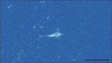
Cubaynes, Hannah ORCID record for Cubaynes, Hannah. Fretwell, Peter ORCID record for Fretwell, Peter. Bamford, Connor ORCID record for Bamford, Connor. Gerrish, Laura ORCID record for Gerrish, Laura. Jackson, Jennifer ORCID record for Jackson, Jennifer. (2018) Whales from space: Four mysticete species described using new VHR satellite imagery.
Despite their importance to Arctic ecosystems, we don’t know how many walruses exist. We’re using satellite images and citizen science to count walruses.
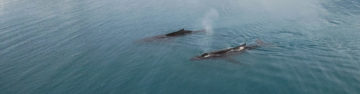
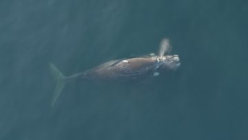
This project is creating a long-term framework for monitoring whale numbers and behaviour.
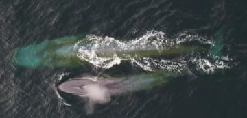
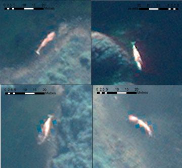
Many populations of wildlife are remote, inaccessible or difficult to monitor. The advent of sub-metre, Very-High-Resolution (VHR) satellite imagery has enabled us study these animals in a much more efficient way.
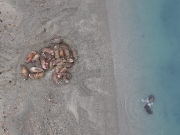
In the first successful attempt to calibrate walrus counts from satellite imagery, scientists used drones to validate animal counts in Svalbard, Norway.
The shortlist has been announced for The Natural Environment Research Council’s (NERC) Impact Awards 2023. Four BAS projects have made the shortlist and commended list, ranging from biodiversity and ecology to space weather.
This week (17 January) British Antarctic Survey and WWF are inviting the public to become ‘walrus detectives’ and get involved in the Walrus from Space project to help with vital […]
Today, 24 November 2022, marks World Walrus Day, and British Antarctic Survey (BAS) and WWF are inviting the British public to become ‘walrus detectives’ and get involved in their Walrus […]
Researchers are heading to the Arctic to begin fieldwork to study walrus populations for the next stage in the Walrus from Space project.
A new dataset featuring hundreds of satellite images of whales has been published to support the development of artificial intelligence systems which will aid crucial conservation work.
An international team of scientists led by British Antarctic Survey have published research today on using new technology to study mass stranding of whales from space and how the technology […]
British Antarctic Survey (BAS) and WWF are seeking the public’s help to search for walrus in thousands of satellite images taken from space, with the aim of learning more about […]
British Antarctic Survey (BAS) scientists will work with an Artificial Intelligence company after being awarded a contract from the Canadian Space Agency (CSA) to support the protection of an endangered […]
Scientists have used detailed high-resolution satellite images provided by Maxar Technologies’ DigitalGlobe, to detect, count and describe four different species of whales. Reported this week in the journal Marine Mammal […]