The British Government established its first stations in Antarctica in 1944. This was part of a wartime expedition known as Operation Tabarin.
Operation Tabarin’s aims were to:
- deter enemy ships from using Antarctic anchorages
- strengthen Britain’s claim to the Falkland Islands Dependencies
- provided an opportunity to carry out scientific research
Operation Tabarin was a joint undertaking by the Admiralty and the Colonial Office. In 1945, it was renamed the Falkland Islands Dependencies Survey (FIDS). Full control then passed to the Colonial Office. At that time, there were four stations. Three were occupied and one was unoccupied.
In 1962, FIDS was renamed British Antarctic Survey (BAS). By then, 19 stations and three refuges had been established. Two further stations have been established since.
The austral summer of 1958–59 saw the largest number of British stations open at any one time. During that season, 13 stations and three refuges were occupied. Four stations currently remain open all year round. Two more are occupied during the austral summer.
Environmental protection and historic sites
Under the Protocol on Environmental Protection to the Antarctic Treaty, abandoned bases and work sites must be cleaned up. The Protocol was agreed on 4 October 1991 and ratified on 14 January 1998.
To comply with the Protocol, we carried out a survey of our closed stations in 1994. As a result, in 1995, four former stations were designated as Historic Sites and Monuments under the Antarctic Treaty and have been preserved.
Ownership of four other former stations has been transferred to other countries. One of these transfers took place before the Protocol came into force.
How the information is organised
During Operation Tabarin, each station was identified by a code letter. This system has continued with the opening of each new station. Descriptions of stations are arranged in code letter order.
Refuges and transit facilities were not identified in this way. They are included under the stations with which they were most closely associated. Many field huts and bird hides have been erected and re-sited over the years. These are also listed under the stations that supported them.
Dates
The dates given for first occupation show when personnel first established a station at that location. This usually involved choosing the site and unloading stores.
Dates given for buildings show when construction began. If this is not known, the date shown is when the building was first occupied overnight. Dates associated with memorials record when lives were lost, not when the memorial was erected.
Note on terminology
Until 1967, all permanent research facilities established by BAS and its predecessors were called bases. Facilities operating since then have officially been referred to as research stations. For simplicity, the term ‘station’ is used throughout this page.
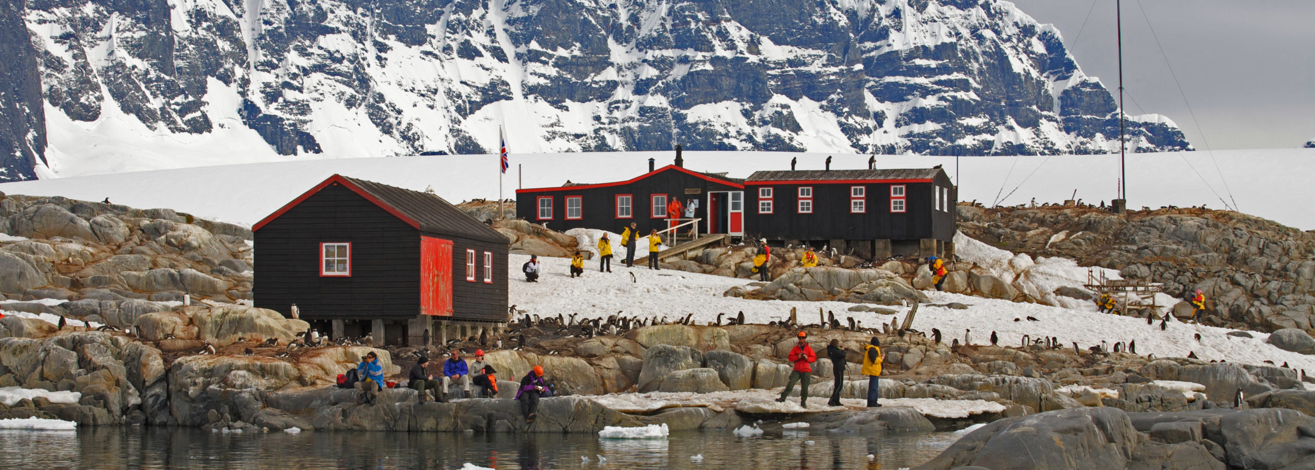
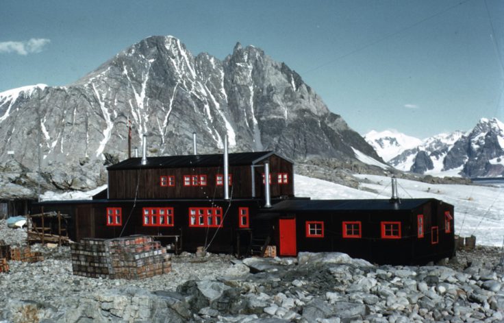
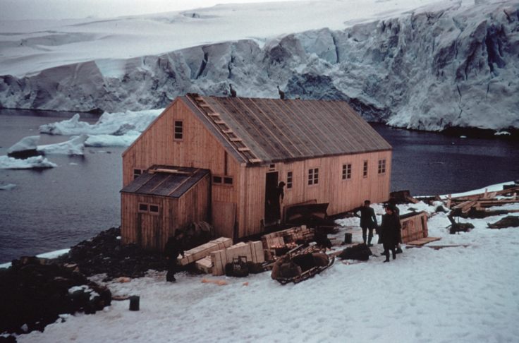
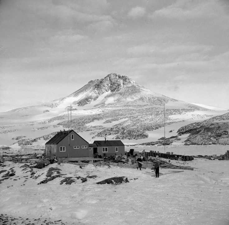
Port Lockroy (Station A)
Position: Lat. 64° 49′ S, Long. 63° 30′ W
General location: Goudier Island, Wiencke Island, Palmer Archipelago
Purpose
Initially survey, geology, meteorology and botany. Mainly ionospheric research from 1950 onwards.
The ionospheric work was transferred to Argentine Islands (Station F) when Station A closed.
Occupied
11 Feb 1944 – 8 Apr 1947
23 Jan 1948 – 14 Feb 1949
24 Jan 1950 – 11 Feb 1951
15 Dec 1951 – 16 Jan 1962
Austral summers since Jan 1996
Buildings
The main hut was named Bransfield House after the ship initially chartered to transport members of Operation Tabarin from the UK, and itself named after Edward Bransfield, Master, Royal Navy, the first person to chart an area of the Antarctic mainland (1819–1820).
Current status
Designated as Historic Site No 61 under the Antarctic Treaty, 19 May 1995. Restored 14 Jan 1996 – 18 Mar 1996.
Since Nov 1996 the station has been manned as an Historic Site on behalf of the UK Antarctic Heritage Trust (UKAHT) for the benefit of tourists and visitors during austral summer seasons. It has been operated directly by UKAHT since Jul 2006 under a Memorandum of Understanding with BAS.
Deception Island (Station B)
Position: 62° 59′ South, 60° 34′ West
General location: Whalers Bay, Deception Island, South Shetland Islands
Purpose
The station served meteorological and geological research. It also functioned as a centre for aircraft operations from 1955–1957 and 1959–1969.
Occupied
3 February 1944 – 5 December 1967
4 December 1968 – 23 February 1969
Evacuation history
The station was temporarily evacuated on 5 December 1967 following volcanic eruptions. Personnel were evacuated again on 21 February 1969 when further eruptions damaged station buildings. On both occasions, the Chilean ship Piloto Pardo carried out the evacuation. The station was permanently abandoned on 23 February 1969 after personnel returned briefly to collect personal possessions.
Buildings
Early structures (1944–1946):
Initially, the station used buildings from the former Norwegian Aktieselskabet Hektor whaling station. These included Bleak House, a converted dormitory that served as the main accommodation and office building until it was destroyed by fire on 8 September 1946.
Main accommodation:
After the fire, another former whaling station dormitory became the main accommodation building. It was named Biscoe House after John Biscoe, a Royal Navy Master who discovered Graham Land in 1832. The Magistrate’s Villa (named for its previous use) served as a store.
Later additions:
A new hut called the FIDASE hut (also known as Hunting Lodge) was built on 13 December 1955 for members of the Falkland Islands Dependencies Aerial Survey Expedition (1955–57), employed by Hunting Aerosurveys Ltd. After the survey concluded, this hut became FIDS property. An aircraft hangar was completed in March 1962. Priestley House, a plastic accommodation building named after Sir Raymond Priestley (Acting Director of FIDS 1955–59 and geologist on Scott’s 1910–13 expedition), was erected in January 1966 but was found missing when RRS John Biscoe visited on 22 March 1985.
Cemetery:
A graveyard was established and used mainly during the whaling era. It was destroyed by mudflows during volcanic eruptions. One FIDS member was buried there. The cemetery site is now marked by a plaque.
Memorials
A. H. Farrant, 17 November 1953: marked by grave
Current Status
Closed. BAS cleaned up the site in 1990/91 and 1991/92.
The Norwegian whaling station remains were designated as Historic Site No. 71 under the Antarctic Treaty on 19 May 1995. In April 2004, the fuselage of BAS single Otter aircraft VP-FAI(K) was removed from the site and has been in storage in the UK under a Memorandum of Understanding since May 2005. Deception Island was designated an Antarctic Specially Managed Area at Antarctic Treaty Consultative Meeting XXVIII (Stockholm, 2005).
Bird Island (Station BI)
Position: Lat. 54° 00′ S, Long. 38° 03′ W
General location: Freshwater Inlet, Jordan Cove, Bird Island, South Georgia
Bird Island was discovered by Captain James Cook in 1775, who sighted and named Bird Island “on account of the vast numbers [of birds] that were upon it”. The uninhabited Willis Islands, 3.2km west of Bird Island, were also named during this expedition after the first crew member who sighted the islands. Sealers were present throughout South Georgia in the late 19th century and signs of their presence on Bird Island is seen in the Sealer’s Cave, beneath Cave Crag, close to Freshwater Beach.
Purpose
Bird and seal research.
Occupied
Intermittently 1957 – 1982. Continuously 22 Sep 1982 – present.
It was used by summer parties from 1957-64 and from 1971-82. Personnel were evacuated on 1 Apr 1982 by HMS Endurance following the Argentine invasion of South Georgia. Reopened on 22 Sep 1982 after cessation of hostilities.
Buildings
Initial buildings 1950s–1970s
Jordan Cove was used by summer parties from 1957 to 1964 and from 1971 to 1982. The first permanent hut was established on 24 November 1958 by the Falkland Islands Government. It was known as Bonner’s Bothy, after W N Bonner, biologist from 1953 to 1986 and BAS Deputy Director between 1986 and 1988.
In December 1962 the United States Antarctic Research Program (USARP) established two huts that were later used by BAS. One of these, used as an accommodation hut, was known as Lönnberg House after the Swedish biologist Einar Lönnberg who expressed great concern at the amount of sealing and whaling on South Georgia in 1906.
Developing infrastructure 1980s–1990s
A new hut was constructed in October 1981 for wintering staff. Following the Argentine invasion of South Georgia, the first wintering party were evacuated on 1 April 1982 by HMS Endurance. The base was re-opened on 22 September 1982 following the cessation of hostilities. The new building was named Beck House after Rolla Howard Beck, an American biologist who made extensive collections of birds around the Falkland Islands, Tierra del Fuego and the Galapagos Islands between 1912 and 1917. This building provided accommodation, laboratory and office space for up to eight people.
A further building containing laboratories, a workshop and storage areas was added in the 1995/96 season. An extension to Beck House was established a year later in the 1996/97 season, housing upgraded accommodation (double bedrooms). Other improvements included an improved water collection and treatment system.
To commemorate Pete Prince, BAS seabird biologist between 1971 and 1998 and Officer in Charge of Bird Island Station from 1993 to 1998, the newly extended Base was renamed Prince House in 1998–99. The storage building was then named Beck House.
Redevelopment 2005
The station complex was completely redeveloped between Jan and June 2005 by Morrison PLC, construction partners of BAS. The new building, occupied from June 2005, was named Prince House. The older building of that name was demolished in Nov 2005 and the site cleared in Jan 2006. The old generator shed (the original Lonnberg / Beck House ) was demolished to make way for the current Prince House and a new generator and fire pump building situated between Beck House and the jetty was built.
Field huts and hides have existed at one time or other at the following sites: Gazella Peak, Molly Hill, Wanderer Ridge, Johnson Gentoo Colony, Top Meadows (two locations), Colony B, Special Study Beach, Colony J and Fairy Point.
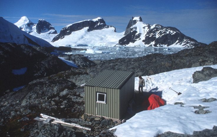
Blaiklock Island (BL)
Position: Lat. 67° 32′ S, Long. 67° 12′ W
General location: North side of Blaiklock Island
Introduction
The hut Blaiklock Island was built in 1957 as a refuge and advance base for survey and geological parties from Horseshoe Island (Station Y). The sea ice around Horseshoe Island had proved unreliable during the previous two seasons, limiting the amount of sled travel and survey work that could be carried out from base.
Purpose
Survey and geology.
Occupied
Intermittently 6 March 1957–1958
Used as a satellite hut for personnel based at Horseshoe Island (Station Y). Also used by parties from Detaille Island (Station W) and Stonington Island (Station E).
Current status
Designated as Historic Site No. 63 under the Antarctic Treaty, 19 May 1995 (included with Horseshoe Island Station). Site cleaned up and minor repairs completed Mar 1997.
It has been managed by UKAHT since Oct 2014 under a Memorandum of Understanding with BAS.
Sandefjord Bay (C)
Position: Lat. 60° 37′ S, Long. 46° 02′ W
General location: Moreton Point, Sandefjord Bay, Coronation Island, South Orkney Islands
Introduction
The original intention had been to establish a station in the South Orkney Islands in 1944 on Signy Island, but this was not achieved. In 1945 a hut was built at Sandefjord Bay, although there were insufficient personnel to occupy it. This has since been referred to as Station P, although there is no evidence for this in the official records. It was replaced by a new hut at Cape Geddes, Laurie Island (which became known as Station C) in 1946.
Occupied
Never occupied.
Buildings
Built 19 Feb 1945. Last seen standing 6 Sep 1950. Collapsed (possibly blown down) by 1 Feb 1955.
Current status
Only debris remains.
Cape Reclus (CR)
Also known as Reclus hut or Portal Point.
Position: Lat. 64° 30′ S, Long. 61° 46′ W
General location: Portal Point, Reclus Peninsula, Danco Coast.
Purpose
Survey and geology.
Occupied
13 Dec 1956 – 25 Apr 1958
Party from Danco Island (Station O) wintered there 1957 to continue local survey work. 4-man party, led by Wally Herbert, completed the first traverse from Hope Bay to Cape Reclus 9 Oct-30 Dec 1957.
Current status
Dismantled in Mar 1996 and transported to the Falkland Islands Museum, Stanley, Falkland Islands. (Erected as an exhibit Dec 1998, refurbished Nov 2007, re-built inside the new Museum 2014.) Only concrete foundations remain at Portal Point.
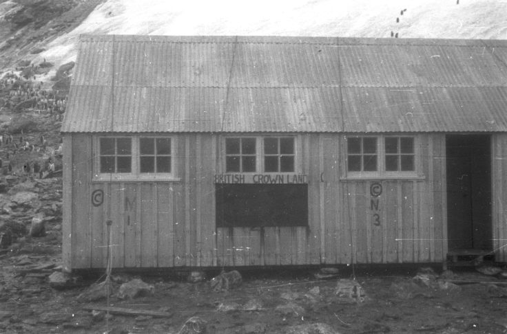
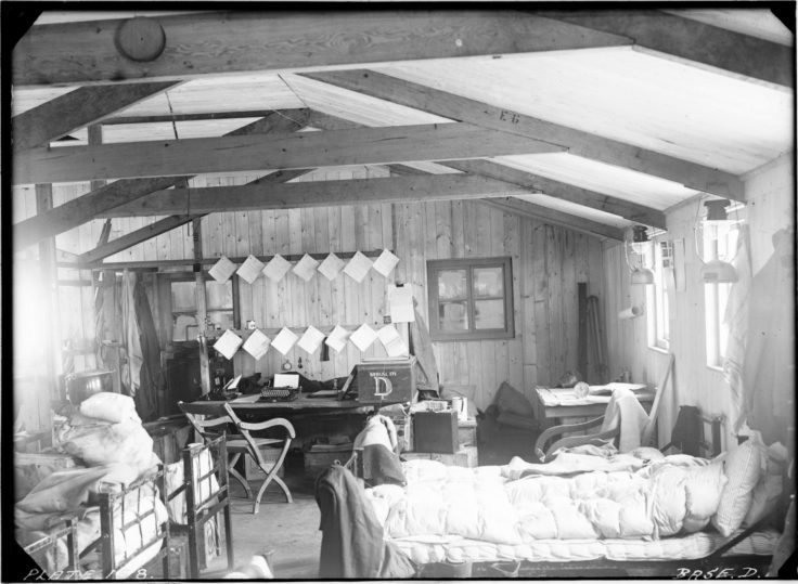
Hope Bay (D)
Position: Lat. 63° 24′ S, Long. 57° 00′ W
General location: Hope Bay, Trinity Peninsula
Purpose
Survey, geology, geophysics, glaciology, meteorology, human and dog physiology.
Occupied
- 13 Feb 1945 – 4 Feb 1949
- 4 Feb 1952 – 13 Feb 1964
An attempt was made to establish the station on 7 Feb 1944 as the main base for Operation Tabarin but sea ice conditions prevented unloading of stores. It was the main station during the expedition’s second year.
Buildings
The original hut was known as Eagle House after the ship SS Eagle which transported the party to Hope Bay in 1945. It was destroyed by fire on 8 Nov 1948, with the loss of two lives. On 4 Feb 1952 a new hut was established in a new position, named Trinity House after Trinity Peninsula.
Memorials
O Burd and M C Green, 8 Nov 1948: graves in the vicinity of the original hut.
Current status
Transferred to Uruguay on 8 Dec 1997 and renamed Teniente Ruperto Elichiribehety Uruguayan Antarctic Scientific Station. Inspected for BAS by a conservation architect in Jan 2007.
Damoy Point (DP)
Position: Lat. 64° 49′ S, Long. 63° 31′ W
General location: Dorian Bay, Wiencke Island, Palmer Archipelago
Purpose
Summer air facility consisting of skiway close to Tombstone Hill and refuge hut at Dorian Bay.
Occupied
Intermittently 1973-12 Nov 1993
Provided a transit station to enable personnel and stores arriving by ship to be flown on to Rothera (Station R) in early summer when sea ice prevented direct access to the station by ship.
Buildings
A hut was established on 6 Nov 1975. Known as Damoy Point hut after the location of the airstrip, although the building is on Dorian Bay. The original plan had been to establish the facility on Doumer Island in 1973 but soft snow conditions made the skiway unusable.
Ski-way
Additional ski-way on Doumer Island, Palmer Archipelago, Lat. 64° 44′ S, Long. 63° 35′ W, 1972/73 and 1974/75.
Current status
Maintained as operational until 2006. Now closed. Site cleaned up 1996/97 and Dec 2007. Designated as Historic Site No. 84 under the Antarctic Treaty, 2009. It has been managed by UKAHT since Oct 2009 under a Memorandum of Understanding with BAS.
Stonington Island (E)
Also known as Marguerite Bay.
Position: Lat. 68° 11′ S, Long. 67° 00′ W
General location: Stonington Island, Marguerite Bay
Purpose
Survey, geology, meteorology and biology.
Occupied
- 25 Feb 1946 – 12 Feb 1950
- 9 Mar 1958 – 7 Mar 1959
- 14 Aug 1960 – 23 Feb 1975
Established 250 yards from the US East Base. The station was closed in 1950 as sea ice conditions had prevented access to relieve the station in 1949. It was reopened in 1960 as the centre for field work in the south Antarctic Peninsula area when Horseshoe Island (Station Y) was closed. The original intention had been to build Station E on the east coast of Graham Land.
Buildings
The original building was known as Trepassey House after the ship MV Trepassey in which it was transported. The station was re-sited when a new main hut was erected on 4 Mar 1961. The new hut was the first two-storey building to be erected by FIDS. It was unnamed. Two single-storey extensions were added, one in 1965 and another begun on 27 Jan 1972. Buildings from East Base were also used as workshops and stores. These were known as Passion Flower Hotel, Jenny’s Roost and Finn Ronne. The derelict Trepassey House was burnt down in stages between Jan 1973 and Jan 1974.
Memorials
J F Noel and T J Allan, Jun 1966: graves on Flagstaff Hill.
Current status
Closed. Site cleaned up by BAS in 1991/92. Designated as Historic Site No. 64 under the Antarctic Treaty, 19 May 1995. Conservation work undertaken by BAS Jan 2003. Inspected for BAS by a conservation architect in Jan 2007. It has been managed by UKAHT since Oct 2014 under a Memorandum of Understanding with BAS.
Faraday (F)
Known as Argentine Islands until 15 Aug 1977.
Position: Lat. 65° 15′ S, Long. 64° 16′ W
General location: Marina Point, Galindez Island, Argentine Islands
Purpose
Geophysics, meteorology and ionospherics.
Occupied
7 Jan 1947 – 6 Feb 1996.
It was occupied continuously for a total of 49 years and 31 days by FIDS and BAS, the longest continuous occupation of any British station to date.
Buildings
The first hut was built on Winter Island, the site of the British Graham Land Expedition (BGLE) hut of 1935-36 which had been destroyed (possibly by a tsunami) in 1946. It was named Wordie House after Sir James Wordie, member of Shackleton’s Imperial Trans-Antarctic Expedition 1914-16, Operation Tabarin Advisory Committee 1943-45 and FID Scientific Committee 1948. It was closed on 30 May 1954 when the station was transferred to Galindez Island, but was re-occupied in the winter of 1960 when personnel for Adelaide (Station T) failed to reach Adelaide Island and had to winter there. New buildings were erected on Galindez Island in Feb 1954. The main building was named Coronation House after the coronation of Queen Elizabeth II in 1953.
Field huts: An Argentine refuge hut on Petermann Island was used periodically by BAS personnel from Faraday Station.
Memorials
- G H Hargreaves, M A Walker and G J Whitfield, Sep 1976: single cross on Rasmussen Island.
- A C Morgan, K P Ockleton and J Coll, 14 Aug 1982: single cross on Petermann Island.
Current status
Wordie House was designated as Historic Site No. 62 under the Antarctic Treaty, 19 May 1995. The Galindez Island station complex was transferred to the Ukraine on 6 Feb 1996 and renamed Vernadsky. Personnel from Vernadsky keep a watching brief on Wordie House. A conservation architect inspected Wordie House for BAS in Jan 2007. It has been managed by UKAHT since Oct 2009 under a Memorandum of Understanding with BAS.
Associated refuge
Admiralty Bay (G)
Position: Lat. 62° 05′ S, Long. 58° 22′ W
General location: Martel Inlet, Keller Peninsula, King George Island, South Shetland Islands
Purpose
Geology, meteorology and glaciology.
Occupied
- 18 Jan 1947 – 23 Mar 1947
- Jan 1948 – 19 Jan 1961
Buildings
The first two buildings, a small wooden hut and a Nissen hut, were erected in Jan 1947. A second wooden hut was established on 14 Feb 1948 but removed in 1950 and re-erected at Signy Island (Station H). A third hut named Sparrow House after the ship HMS Sparrow in which it was transported, was established about 300 yards south of the second hut on 28 Jan 1949. A further hut was erected on 6 Jan 1956.
Memorials
- E Platt, 10 Nov 1948: grave.
- R G Napier, 24 Mar 1956: memorial cross.
- A Sharman, 23 Apr 1959: grave.
- D R Bell, 26 Jul 1959: memorial.
Current status
Demolished and removed by members of the Brazilian Antarctic Expedition at Comandante Ferraz Station, Jul 1995 – Feb 1996. Only concrete foundations remain.
Signy (H)
Position: Lat. 60° 43′ S, Long. 45° 36′ W
General location: Factory Cove, Borge Bay, Signy Island, South Orkney Islands
Introduction
Scientific research began on Signy Island in 1947 when a three-man team occupied a site in Factory Cove above the old whaling station. The base they established was called Signy Island, known as Signy from Aug 1977.
George Powell and Nathaniel Palmer, British and American sealers, discovered the South Orkney island group in 1821. A few years later, Matthew Brisbane, as part of an expedition led by James Weddell, surveyed the south coast of Coronation Island and discovered Signy, although he did not name the island. Powell named Coronation Island to celebrate the crowning of George IV. Visitors to the islands were rare until 1902 when the Scottish National Antarctic Expedition, led by William Speirs Bruce, established a base on Laurie Island. However, in 1904 the British Government declined to support the expedition and the base was handed over to the Argentinians who have remained there ever since in what is now known as Orcadas Station. Whaling started in the South Orkney Islands in 1907–08. Petter Sørlle, captain of the whale catcher Paal, surveyed the island in 1912–13, naming Signy after his wife and a number of the surrounding islands after his daughters.
Purpose
Biology.
Occupied
- 18 Mar 1947 – 13 Apr 1996
- Austral summers 1996/97 – present
Occupied continuously for a total of 49 years 27 days.
Buildings
The original building was erected on Berntsen Point, overlooking Factory Cove. It was named Clifford House after Sir Miles Clifford, Governor of the Falkland Islands 1947–1954.
A laboratory was added on 12 Feb 1948 and an extension to the main hut on 25 Feb 1950. The latter building had originally stood at Admiralty Bay (Station G). These buildings were re-sited in Factory Cove. The main building established on 3 Feb 1955 was named Tønsberg House after the whaling company Tønsbergs Hvalfangeri. It was established on the site of the company’s old whaling station at Factory Cove. Construction of a plastic hut containing living accommodation and laboratories began on 18 Dec 1963. A bulk fuel tank was built in 1965. Sørlle House was erected Dec 1980 to house diving and laboratory facilities. It was named after the Sørlle family – Petter Sørlle was the whaling ship Captain who surveyed the South Orkney Islands 1912-13. It was demolished in Mar 1995. During the 1995/96 season a new Sørlle House was erected on the foundations of the old, providing improved living accommodation, laboratories and offices, and a fuel farm established. In Jan 1997 the plastic hut was closed except for use as a store. During the 2001/02 season the plastic hut, Tønsberg House, 1965 bulk fuel tank and pump house were demolished.
Field huts and hides have existed at one time or another at the following sites: Foca Cove, Gourlay Peninsula, Three Lakes Valley, Cummings Cove, Jane Col, Factory Bluffs, Moraine Valley, Shagnasty and North Point. Shingle Hut, built in Jan 1963 at Shingle Cove, Coronation Island, was used as a depot and staging post for personnel travelling on Coronation Island (demolished and removed February 2007).
Memorials
R. Filer, 13 Feb 1961: grave on Pantomime Point.
Current status
Occupied during austral summers.
Prospect Point (J)
Position: Lat. 66° 00′ S, Long. 65° 21′ W
General location: Prospect Point, Ferin Head, Graham Coast.
Introduction
The letter J was originally intended for a station on Alexander Island in the 1948/49 season which was never established. The base established at Prospect Point was originally known as Graham Coast until 1959.
Purpose
Survey and geology.
Occupied
2 Feb 1957 – 23 Feb 1959.
Closed when local work completed
Buildings
The hut was named Penola after the support ship of the British Graham Land Expedition.
Current status
Removed during March – April 2004.
Station K
Letter K was allocated to a station which was to have been set up on Snow Hill Island or Joinville Island in 1948/49, but plans were abandoned when sea ice prevented access.
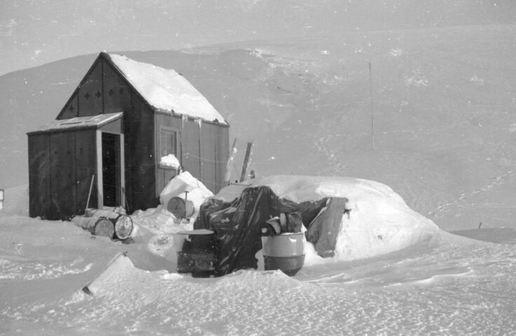
Fossil Bluff (KG)
Position: Lat. 71° 20′ S, Long. 68° 17′ W
General location: Fossil Bluff, Alexander Island
Purpose
Survey, geology, glaciology and field geophysics. Advanced station for field parties from Stonington Island (Station E), Adelaide (Station T) and Rothera (Station R). Now a forward logistics facility with skiway.
Occupied
Intermittently 20 Feb 1961 to present.
Occupied during the winters of 1961, 1962, 1969-75. Closed for the 1976 winter when Rothera (Station R) became fully operational. Occupied intermittently for summer seasons since then. Supplied overland from Stonington Island (Station E) and later by air from Adelaide (Station T) and Rothera.
Buildings
Established by air Feb 1961. Relieved by Muskeg tractor trains bringing vehicles and stores from Base E, Stonington Island, Nov 1961 and Oct 1962. The main hut was named Bluebell Cottage. Sledge store lean-to on south end of hut, generator shed on north end. Porch added 1970. Feb 1971 extension built for a workshop. Foundations shored-up due to erosion of the moraine in 1970 (retaining wall and terrace), further work 1982. As ice has receded the location of the hut has become more exposed on the edge of a steep scree slope. 1968-69 temporary shelter used in the absence of a garage and in 1970 a plastic shelter was provided. Store hut erected 1972/73. 1973/74 garage erected to replace the plastic shelter, which was moved and re-erected as a store for a number of years. Generator hut (date unclear).
Field huts
A caboose was part of the tractor train from Base E in 1962. It was used as mobile accommodation (towed by Muskeg) for glaciological field parties 1971-74. A small hut was erected at Spartan Cwm (date not clear) to support glaciological studies there and a 2nd larger hut in 1974. The latter became a living hut, the older structure a store.
Current status
Forward fuel depot, facility for re-fuelling aircraft and field station for parties from Rothera (Station R) during austral summers. Site was cleaned-up by BAS during the 2002/03 and 2003/04 seasons.
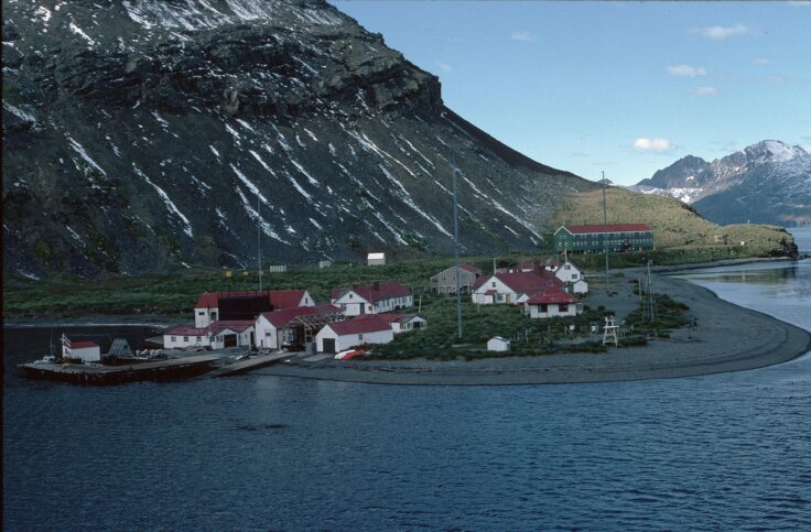
King Edward Point (M)
Position: Lat. 54° 17′ S, Long. 36° 30′ W
King Edward Point, Cumberland East Bay, South Georgia
Introduction
The UK Government established a laboratory at King Edward Point, South Georgia in 1924–25 as part of the Discovery Expedition. Discovery House was built and initially used for accommodation, and later as a store and workshop.
From 1950 to 1952 the Falkland Islands Dependencies Survey briefly operated the meteorological station at King Edward Point. Then, with the cessation of whaling at Grytviken, in 1969 BAS took over the administration of KEP, running a diversity of scientific programmes. This ceased with the outbreak of the South Atlantic Conflict, when the island was invaded by Argentine troops on 3 April 1982. Thirteen BAS staff present at the station were forcibly removed to the Argentine ship Bahia Paraiso. A further nine BAS scientists and two photographers from Anglia TV were undertaking fieldwork at the time of the invasion and remained at various field huts on the island until it was liberated on 25 April 1982. A British Military garrison occupied King Edward Point from then until 2001.
On 22 March 2001, the Commissioner for the Government of South Georgia and the South Sandwich Islands (GSGSSI) opened the marine and fisheries research station at King Edward Point, South Georgia. The opening of the purpose-built laboratory and accommodation facilities, which coincided with the withdrawal of the small British garrison from South Georgia, marked the return of biological research to King Edward Point after an absence of nearly 20 years.
(Known as South Georgia or King Edward Point until 17 Oct 1977 and as Grytviken 1977–1982)
Purpose
Originally biology, meteorology, geophysics and glaciology. Since 2001, primarily commissioned research on sustainable fisheries and support for an administrative presence on the island on behalf of the South Georgia and South Sandwich Islands Government.
Occupied
- 1 Jan 1950 – 1 Jan 1952
- 13 Nov 1969 – 3 Apr 1982
- 22 March 2001 onwards
Buildings
FIDS/BAS occupied buildings of the Falkland Islands Dependencies Government administrative settlement on King Edward Point, across the bay from the whaling station at Grytviken (operated by Compañia Argentina de Pesca, 1909-1960). Discovery House was built for the Discovery Expedition in 1924/25. It was used for accommodation but later became a store and workshop. Shackleton House (demolished 2001/02 season) was built 1962/63 as a hospital and for accommodation. It was named after Sir Ernest Shackleton, the explorer who made the first major trek across South Georgia in 1915 and who was buried there in 1922. Other buildings used included the Customs House (demolished 2000/01 season), Coleman’s, the former residence of the last government administrator D J Coleman (burnt down during UK military occupation), and Quigley’s, the former residence of the last engineer on the government staff, J Quigley (later the medical facility).
During the 2000/01 season four new buildings were erected. The biological laboratory was named the James Cook Laboratory after Captain James Cook, RN, discoverer of South Georgia and pioneer of Antarctic exploration. A new accommodation building, Everson House, was named in honour of Inigo Everson, BAS marine biologist 1964-2002. A self-contained apartment, named Shackleton Villa, attached to Everson House was provided for the Government Marine Officer and is now used for additional Government accommodation. The other buildings were a food store and generator/boat shed. Larsen House, named after Captain Carl A Larsen, Norwegian whaler and explorer, provides additional accommodation during the summer months. It was built in 1992 and substantially upgraded 2001/02. In 2006 a new building was erected for the Government Officer, and named Carse House after Duncan Carse, who led the South Georgia Surveys of the 1950s.
Temporary field station
A limited amount of science was resumed in 1986. The abandoned whaling station at Husvik was used as a summer field station from 1986/87-1988/89 and 1990/91-1995/96.
Field huts
Field huts have existed at one time or another at the following sites: Sörling Valley, Elsehul, Schlieper Bay, Hound Bay, Dartmouth Point, Glacier Col, Maiviken, St Andrews Bay, Hope Point, Coral Bay, Gull Lake, Carlita Bay, Royal Bay, Hodges Glacier, Jason Harbour, Ocean Harbour, Prince Olav Harbour, Lyell Glacier, Bay of Isles and Godthul. The abandoned whaling stations at Leith Harbour and Stromness have also been used. Many derelict huts removed 2005/06 season.
Current status
Operational throughout the year.
Anvers Island (N)
Position: Lat. 64° 46′ S, Long. 64° 05′ W
General location: Arthur Harbour, Anvers Island, Palmer Archipelago
Purpose
Survey and geology.
Occupied
28 Feb 1955-10 Jan 1958. Open in support of air facility 1969-1971. Skiway on Marr Ice Piedmont used 1969-1973 and then intermittently until 15 Nov 1993, and once in Dec 1999.
Closed in 1958 when local work completed. Air operations transferred to Adelaide (Station T) in 1973 when the skiway deteriorated.
Buildings
The hut was loaned to the US Government 2 July 1963 and converted into a biological laboratory in Jan 1965 for use by 1956/57 American scientists at the nearby Palmer Station. Destroyed by fire while being renovated by BAS on 28 Dec 1971.
Current status
Destroyed. Debris was removed by the members of the US Antarctic Program in 1990/91. Only concrete foundations remain.
Danco Island (O)
Position: Lat. 64° 44′ S, Long. 62° 36′ W
General location: Danco Island, off Danco Coast
Introduction
The original intention had been to build the base hut on Brabant Island but no suitable site could be found. Danco Island was closed once local work was completed.
Purpose
Survey and geology.
Occupied
26 Feb 1956 – 22 Feb 1959.
Buildings
Main hut was named Arendal, the original name of the RRS Shackleton, the vessel that established the station.
Current status
Demolished and removed by BAS Apr 2004. Only concrete foundations remain.
Associated refuge
Orford Cliff refuge (OC)
Also known as Johnston’s Point
Position: Lat. 66° 55′ S, Long. 66° 29′ W
General location: Orford Cliff, Lallemand Fjord, Loubet Coast
Purpose
Survey and geology.
Occupied
Intermittently 21 Feb 1957 – 10 Jan 1959.
Used as a satellite hut for personnel based at Detaille Island (Station W).
Current status
Demolished and removed 25 Mar 1997. Only concrete foundations remain.
Livingston Island (P)
Position: (Approx) Lat. 62° 40′ S, Long. 61° 00′ W
General location: Livingston Island, South Shetland Islands
Purpose
Survey, geology and biology.
Occupied
29 Dec 1957 – 15 Mar 1958.
A temporary, mobile camp for use by field parties on Livingston Island. The letter P was used as the intention had been to erect a hut. In all other cases it has not been the practice to assign letters to field camps.
Buildings
RRS Shackleton was holed when transporting the hut, parts of which were used to repair the ship.
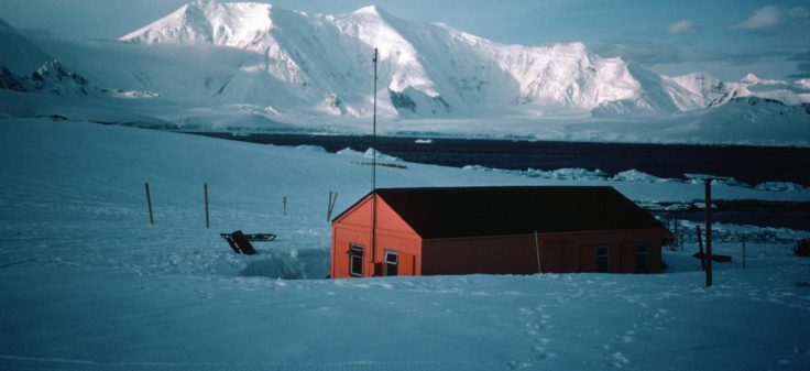
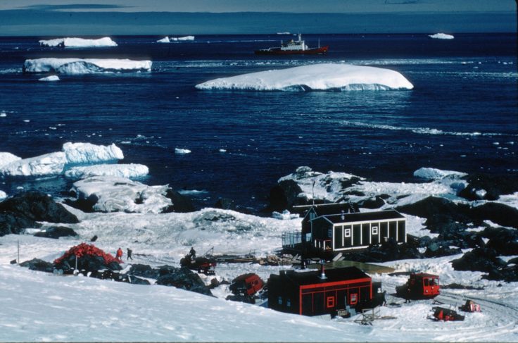
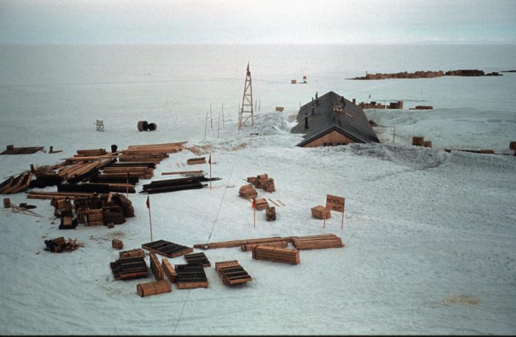
Rothera (R)
Position: Lat. 67° 34′ S, Long. 68° 08′ W
General location: Rothera Point, Adelaide Island
Introduction
From 1955 to 1960, the UK maintained a survey station on Horseshoe Island (Station Y) on the east side of Marguerite Bay. In 1957, a surveyor, John Rothera, crossed the frozen sea ice and explored the area now known as Rothera Point. From 1961 to 1977, UK activity in the area was conducted from Adelaide (Station T) located at the southern tip of the island. For many years this proved a good base from which to undertake further survey of the Antarctic Peninsula
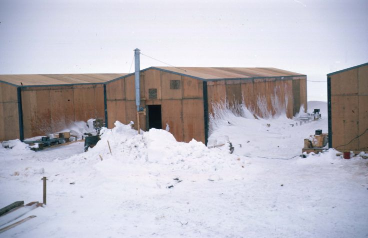
Rothera Station, known as Rothera Point until 15 August 1977, was established in 1975 to replace Adelaide, where the glacier ski-way had deteriorated rendering the operation of ski-equipped aircraft hazardous. A party camped at Rothera Point in the 1975/76 austral summer to open up the air facility. There was a phased construction programme so that by 1980 the station provided accommodation, electrical power generation, vehicle workshops, scientific offices and a store for travel equipment.
From Rothera’s inception to the 1991–92 austral summer season, BAS Twin Otter aircraft used a glacier ski-way 300m above the station on the Wormald Ice Piedmont. During that summer a gravel runway and hangar facility was commissioned bringing a more reliable air operation and the possibility of a passenger aircraft link from outside the continent. Before that, everyone coming to Rothera had to depart from the Falkland Islands by ship.
Today the development of the Rothera site continues. This is not an expansion but an ongoing programme of replacing old structures making best use of new technologies. Improved insulation and energy production and management systems can further reduce the environmental footprint of the station.
Purpose
Marine biology, deep-field support to glaciology, geology, geophysics and survey. Main air facility and field work centre.
Occupied
25 Oct 1975 to present.
Buildings
The station was initially planned and constructed in 3 phases to spread the costs.
First hut erected on 1 Feb 1976. Phase II was built in 1976/77. This included the main accommodation block, power house and tractor shed. An old storage shed from Adelaide (Station T) was erected close to Phase I and known as the Bingham building after Surgeon Commander E W Bingham, leader of FIDS 1945-47. Phase III was erected 1978/79. This building included scientific offices, travel store and a coldroom. In 2001 it was named Fuchs House after Sir Vivian Fuchs, Director of FIDS/BAS 1958-73.
Further building work has been undertaken when required. Phase IV, begun Nov 1985 and completed in the 1986/87 season was an extension to Phase II. In 2001 it was named Bransfield House (after BAS ship RRS Bransfield). A wharf and gravel runway (with bulk fuel tanks and aircraft hangar) became operational in the 1991/92 season. The former was named Biscoe Wharf after the BAS ship RRS John Biscoe. A new storage hut, called the Miracle Span, now used primarily for waste management activities, was also constructed in 1991/92.
Under the next phase of development, a boatshed was completed in 1994/95, a transit accommodation block in 1996/97 (named Giants House in 2001 after the Rothera sledge dog team “Giants”), and a new generator shed. The Bonner Laboratory became operational in 1997, housing biological research facilities when Signy (Station H), was reduced to summer only operations. It was named after W N Bonner, biologist 1953-86 and Deputy Director of BAS 1986-88. A new accommodation building was erected during the 1999/00 and 2000/01 seasons. It was named Admirals House after the Rothera dog team “Admirals”. Also in 1999/00 an air operations control tower was added to the north end of Bransfield House. The Bonner Laboratory was destroyed by fire on 29 Sep 2001 but rebuilt in the 2002/03 season, when a sewage treatment plant was also erected. A new living block, including canteen, library and recreational facilities, was completed in 2007/08 and named new Bransfield House. The upper floor of old Bransfield House then became redundant.
2013 Dirck Gerritsz Laboratory was officially opened on Sunday 27 Jan by Leo le Duc on behalf of the Ministry of Education, Culture and Science of the Netherlands. A collaboration between the British Antarctic Survey and the Netherlands Organisation for Scientific Research (NWO) – hosting 4 research projects.
Field huts
A hut was established on Lagoon Island 30 Nov 1989 as a shelter for those on recreational trips. Two field huts were erected on Léonie Island in Dec 1996. Known as the Melon hut and the Apple hut, they were provided by the Netherlands AntArctic Programme (sic) during a collaborative study with BAS. A second Melon hut was erected at Two Step Cliffs, Alexander Island, in 1998/99.
Memorials
S E Black, D Statham and G Stride, 27 May 1958: memorial at Rothera Point.
J H M Anderson and R Atkinson, 16 May 1981: single cross on Rothera Point.
N J Armstrong (Canada), D N Fredlund (Canada), J C Armstrong (Canada) and E P Odegard (Norway), 23 Nov 1994: memorial at Rothera Point.
K M Brown, 22 July 2003: memorial at Rothera Point.
Current status
Operational throughout the year.
Associated transit facility
Rasmussen Hut (RS)
Also known as Rasmussen Point
Position: Lat. 65° 15′ S, Long. 64° 06′ W
General location: Rasmussen Island, Waddington Bay, Graham Coast
Purpose
Emergency refuge and recreational shelter.
Occupied
Occasional use Mar 1984–6 Feb 1996.
Building started 29 March 1984, completed early 1985.
Current status
Closed. Used occasionally by Ukrainian personnel from Vernadsky Station.
Adelaide (T)
Position: Lat. 67° 46′ S, Long. 68° 55′ W
General location: South-west Adelaide Island
Introduction
Adelaide Island was first sighted from the brig Tula in February 1832 when completing a circumnavigation of the Antarctic continent. The ship’s master, John Biscoe, named the land after Queen Adelaide, the wife of British monarch King William IV. It was not until the British Graham Land Expedition of 1934–37 that Adelaide was confirmed to be an island separate from the Antarctic Peninsula. The base at Adelaide Island (referred to as Adelaide from July 1962) was established on 3 February 1961 on the south-west tip of the island. This was in preference to Rothera Point as it had a better skiway for aircraft and less sea ice to hinder access by ship. It was closed when the skiway deteriorated and operations were transferred to Rothera (Station R).
Purpose
Survey, glaciology, geology and meteorology. Main air facility and centre for airborne earth sciences programme.
Occupied
3 Feb 1961 – 1 Mar 1977.
Jerome and Sally Poncet wintered there in 1978 aboard the yacht Damien II.
Buildings
The original building was known as Stephenson House after A Stephenson, surveyor on the British Graham Land Expedition (BGLE) 1934-37. An additional hut named Rymill House after J R Rymill, leader of BGLE, was erected in Mar 1962. A separate accommodation hut named Hampton House after W E Hampton, deputy leader and chief pilot of the BGLE, was erected on 1 Jan 1963. This was formerly the garage at Fossil Bluff (Station KG). A plastic accommodation building was established on 3 Mar 1967.
Current status
Transferred to Chile 14 Aug 1984 and renamed Teniente Luis Carvajal Villaroel Antarctic Base (Teniente Carvajal).
View Point (V)
Position Lat. 63° 33′ S, Long. 57° 21′ W
General location: Duse Bay, Trinity Peninsula
Purpose
Survey, geology and meteorology.
Occupied
Intermittently 3 June 1953 – 25 November 1963.
Established as a satellite base for Hope Bay (Station D).
Buildings
Site selected 8 Feb 1953, foundations of first hut laid 3 June 1953. A second hut was erected on 20 Mar 1956 and called Seal-catcher’s Arms or View Point Hut.
Current status
Transferred to Chile on 29 July 1996 and renamed General Ramon Canas Montalva. Inspected for BAS by a conservation architect in Jan 2007.
Detaille Island (W)
Known as Loubet Coast until Jun 1959
Position: Lat. 66° 52′ S, Long. 66° 48′ W
General location: Detaille Island, Lallemand Fjord, Loubet Coast
Purpose
Survey, geology and meteorology.
Occupied
21 Feb 1956 – 31 Mar 1959.
Evacuated when sea ice and weather made relief by ship impossible. Personnel closed the station and transferred to Horseshoe Island (Station Y).
Buildings
Unnamed.
Current status
Closed. Site cleaned up by BAS 1996/97, 2002/03 and 2003/04 seasons. Inspected for BAS by a conservation architect in Jan 2007. Designated as Historic Site No. 83 under the Antarctic Treaty, 2009. It has been managed by UKAHT since Oct 2009 under a Memorandum of Understanding with BAS.
Associated refuge

Horseshoe Island (Y)
Position: Lat. 67° 48′ S, Long. 67° 17′ W
General location: Sally Cove, Horseshoe Island, Bourgeois Fjord, Marguerite Bay
Introduction
The base at Horseshoe Island was established by the Falkland Islands Dependencies Survey in 1955. This was part of the push to increase UK scientific activity ahead of International Geophysical Year, 1957-58, with a number of bases opened during this period. This included Anvers Island (Base N), also in Marguerite Bay, which was opened that same year. Horseshoe Island was primarily used for geology and survey, and provided meteorological observations that linked a chain of met stations. The combined survey task of Horseshoe Island and Detaille Island (Base W) was to establish a ground control network for the air photography being carried out by the Falkland Islands Dependencies Aerial Survey Expedition (FIDASE), 1955-57.
Purpose
Survey, geology and meteorology.
Occupied
- 11 March 1955 – 21 August 1960
- 7 March 1969 – 11 July 1969
Closed in 1960 when personnel transferred to Stonington Island (Station E). Reopened briefly in 1969 to complete local survey work.
Buildings
Unnamed.
Memorials
S E Black, D Statham and G Stride, 27 May 1958: single cross on Beacon Hill.
Current status
Closed. Used occasionally by BAS personnel on field trips from Rothera (Station R). Site cleaned up by BAS Mar 1995. Designated as Historic Site No. 63 under the Antarctic Treaty, 19 May 1995 (includes Blaiklock Island refuge). Building conservation work undertaken in Mar 1997. Inspected for BAS by a conservation architect in Jan 2007. It has been managed by UKAHT since Oct 2014 under a Memorandum of Understanding with BAS.
Associated refuge
Halley (Z)
Position: Lat. 75° 35′ S, Long. 26° 39′ W (2012 Halley VI)
General location: Brunt Ice Shelf, Caird Coast
Introduction
The original base at Halley was founded on 6 January 1956 by an expedition of the Royal Society as part of International Geophysical Year 1957–58. The bay where the expedition decided to set up their base was named Halley after the astronomer and Fellow of the Royal Society, Edmond Halley. The year 1956 also marked the tercentenary of Halley’s birth. In 1977, the name of the base was amended from Halley Bay to Halley as the original bay had disappeared due to changes in the ice shelf.
Halley is sited on the Brunt Ice Shelf where approximately 1.2 metres of snow accumulate each year. Buildings on the surface become covered and eventually crushed by snow, necessitating periodic rebuilding of the station. This part of the ice shelf is also moving westward by approx. 1km per year. There have been six Halley stations built so far. The first four were all buried by snow accumulation and crushed until they were uninhabitable. Various construction methods have been tried over the years, from unprotected wooden huts to steel tunnels to the present-day distinctive modular design on hydraulic skis.
Previous locations
- 1956 (IGY) Lat. 75° 31′ S, Long. 26° 36′ W
- 1957 (IGY) Lat. 75° 30′ S, Long. 26° 36′ W
- 1967 (Z II) Lat. 75° 31′ S, Long. 26° 39′ W
- 1973 (Z III) Lat. 75° 31′ S, Long. 26° 43′ W
- 1983 (Z IV) Lat. 75° 36′ S, Long. 26° 40′ W
- 1989 (Z IV) Lat. 75° 36′ S, Long. 26° 46′ W
- 1988 (Z V) Lat. 75° 35′ S, Long. 26° 14′ W
- 1992 (Z V) Lat. 75° 35′ S, Long. 26° 19′ W
- 1998 (Z V) Lat. 75° 35′S, Long. 26° 30′ W
- 2001 (Z V) Lat. 75° 35′ S, Long. 26° 34′ W
Purpose
Primarily atmospheric sciences, but also survey, geology and glaciology.
Occupied
6 Jan 1956 to the present.
The 2001/02 season was the only time in the station’s history when sea ice conditions made it impossible to relieve the station by sea.
Buildings
Halley I
The original station, Halley I, or Halley Bay, was established by the Royal Society on 6 Jan 1956 for the International Geophysical Year (IGY) 1957/58. It was a traditional hut with a pitched roof. FIDS took over the operation of the station on 14 January 1959. A new main hut and dog kennels were built close to the original IGY buildings in February 1961, by which time the latter were completely covered by snow. It was closed early 1968.
Halley II
Halley II was built January–March 1967. It was designed with a pitched roof reinforced with steel supports. Halley I and Halley II were both occupied during the 1967 winter, Halley II being known as The Village and Grillage Village. It closed in 1973.
Halley III
Halley III was begun in early 1973. It was built of prefabricated huts housed inside corrugated steel conduits. Halley II and Halley III were both occupied in the 1973 winter. It was closed in February 1984 and the site was cleaned up in 1991.
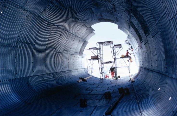
Halley IV
Halley IV was established 2 January 1983. It was composed of two-storey huts housed inside conduits made from interlocking plywood-faced panels. Both Halley III and Halley IV were occupied in the winter of 1983. It was closed on 19 February 1992 and the site was cleaned up during the 1992/93 season.
Halley V
Halley V was begun in Jan 1989 and was fully operational from 19 Feb 1992. To avoid destruction by accumulating snow the main buildings were positioned on steel platforms that were raised annually so that they remained above the surface. The Laws building, named after Dr R M Laws, Director of BAS 1973-87, was the main accommodation building. The Piggott building, named after Dr W R Piggott, Head of Atmospheric Sciences Division of BAS 1973-79, contained the space sciences laboratories. The Simpson building, named after Sir George Clarke Simpson, meteorologist on Scott’s expedition 1910-13 and Director of the Meteorological Office 1920-38, contained the meteorological laboratories. The Drewry building, named after Dr D J Drewry, Director of BAS 1987-94, provided summer accommodation. Following the example of a new garage installed the year before, the Drewry building was mounted on skis enabling it to be repositioned every year. A Clean Air Sector Laboratory was erected 1km from the main complex in 2002/03.
Continued occupation of the station became precarious as it had flowed too far from the mainland to a position at risk of calving as an iceberg – the legs of the platform on which it was based, were fixed in the ice and could not be moved. Scientific activities at Halley V had to be reduced from the 2007/08 season to aid the construction of Halley VI.
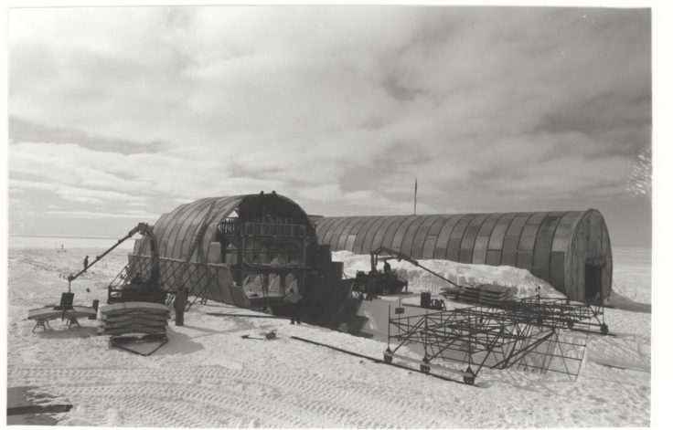
Halley VI
Halley VI Research Station was commissioned in 2006 and its unique and innovative structure was the result of an international design competition launched by the Royal Institute of British Architects (RIBA) and BAS in June 2004. Construction work began in December 2007 and the station took four years to build, delivering its first scientific data in 2012. The completed station consists of five linked modules on hydraulic legs fitted with skis, enabling the units to be towed into new positions.
Halley VI was occupied during the winter 2012 with the official opening on 5 February 2013. The ceremony at the station was attended by Mike Pinnock from BAS, Ed Wallis, NERC Council chairman, and Jeremy Clayton, Department of Business Innovation & Skills. Simultaneously there was an event held at the Royal Society in London, attended by David Willetts, the Minister for Universities and Science, and many others who had made contributions to or had an interest in Halley VI.
Field huts
The Bob-Pi hut was erected in the hinge zone on 6 November 1962. It was used as a depot and staging post for journeys into Coats Land as well as for recreational purposes.
Coats Station was established in Coats Land, at Lat. 77° 54′ S, Long. 24° 08′ W, 200 miles south of Halley Station on 30 November 1964. It was positioned to allow the triangulation of ionospheric measurements to be taken in conjunction with Halley Station and the Argentine General Belgrano Station. It was manned until 18 March 1965 when it was removed.
Memorials
- N S Mann, 15 Aug 1963: plaque at Halley Station.
- J T Bailey, D P Wild and J K Wilson, 12 Oct 1965: plaques erected on Survey Point, Vardeklettane, Heimfrontfjella and at Halley Station.
- M V Mosley, 2 Feb 1980: memorial at Halley Station.
Current status
Operational throughout the year.