An international team of scientists is heading to Greenland this summer for a two-month expedition to discover how quickly the ice sheet’s rapidly melting glaciers are pushing the Atlantic Ocean towards a critical climate tipping point.
Their fieldwork is part of a five-year project, known as GIANT (Greenland Ice sheet to AtlaNtic Tipping points), a large international collaboration of 17 partners led by British Antarctic Survey (BAS) and funded by the Advanced Research + Invention Agency (ARIA).
Through GIANT, researchers hope to understand how much meltwater is released from Greenland’s fjord glaciers, how it enters the North Atlantic Ocean and this process influences ocean circulation and the global climate system. Despite the implications for lives and livelihoods around the world, scientists currently don’t have a clear picture of how Greenland’s fjord glaciers interact with the surrounding ocean, and the 200 or so narrow fjords have so far been impossible to capture in global computer models.
To gather unprecedented observations this summer, researchers will head to Greenland to deploy a sophisticated suite of technologies, including airborne drones, autonomous marine robots, satellites and instruments embedded directly into glacier ice. This coordinated observing system will allow researchers to study glacier behaviour on all scales, from individual cracks in the ice all the way up to the flow of meltwater and icebergs into the North Atlantic. This data collection will feed directly into multiple computer models boosted by both machine learning and AI.
As a result, scientists will incorporate Greenland’s fjords into the UK’s main climate model and develop a prototype Early Warning System that could provide advance notice of rapid glacier change.

What is a tipping point?
Climate tipping points are critical thresholds within Earth’s systems – such as ice sheets, rainforests or ocean currents – beyond which change can become rapid, self-perpetuating and potentially irreversible. Despite their importance, current climate models struggle to predict exactly when these tipping points will be crossed or what their full consequences will be.
As Greenland’s melting ice discharges vast quantities of freshwater into the ocean, scientists are concerned that this might affect a major Atlantic Ocean current system: the North Atlantic Subpolar Gyre. This system transports heat from the tropics to the North Atlantic, helping to regulate temperatures and weather in Europe and North America. Adding fresh meltwater from Greenland’s glaciers may put a ‘cap’ on the Subpolar Gyre, preventing the formation of warmer, dense water that powers the wider global ocean conveyor belt that moves heat and nutrients around the world. Some estimates suggest the North Atlantic Subpolar Gyre could change as early as the 2040s.
Aims of the expedition
GIANT will focus on two types of glaciers in Greenland that offer contrasting but complementary insights into glacier stability. First, tidewater glaciers near Kangerlussuaq in South-East Greenland flow through long, narrow fjords and end in towering ice cliffs. Here, frequent iceberg calving creates an ice mélange; a dense, slushy pack of sea ice and chunks of icebergs that can temporarily prevent more iceberg calving in winter. When this debris clears in the summer, glaciers can retreat rapidly.
By contrast, Petermann Glacier in North-West Greenland is wider and terminates in a long floating ice tongue, or ice shelf, where the floating glacier extends out into the ocean. Studying both systems will help scientists understand how different types of glacier respond to ocean and atmosphere warming.
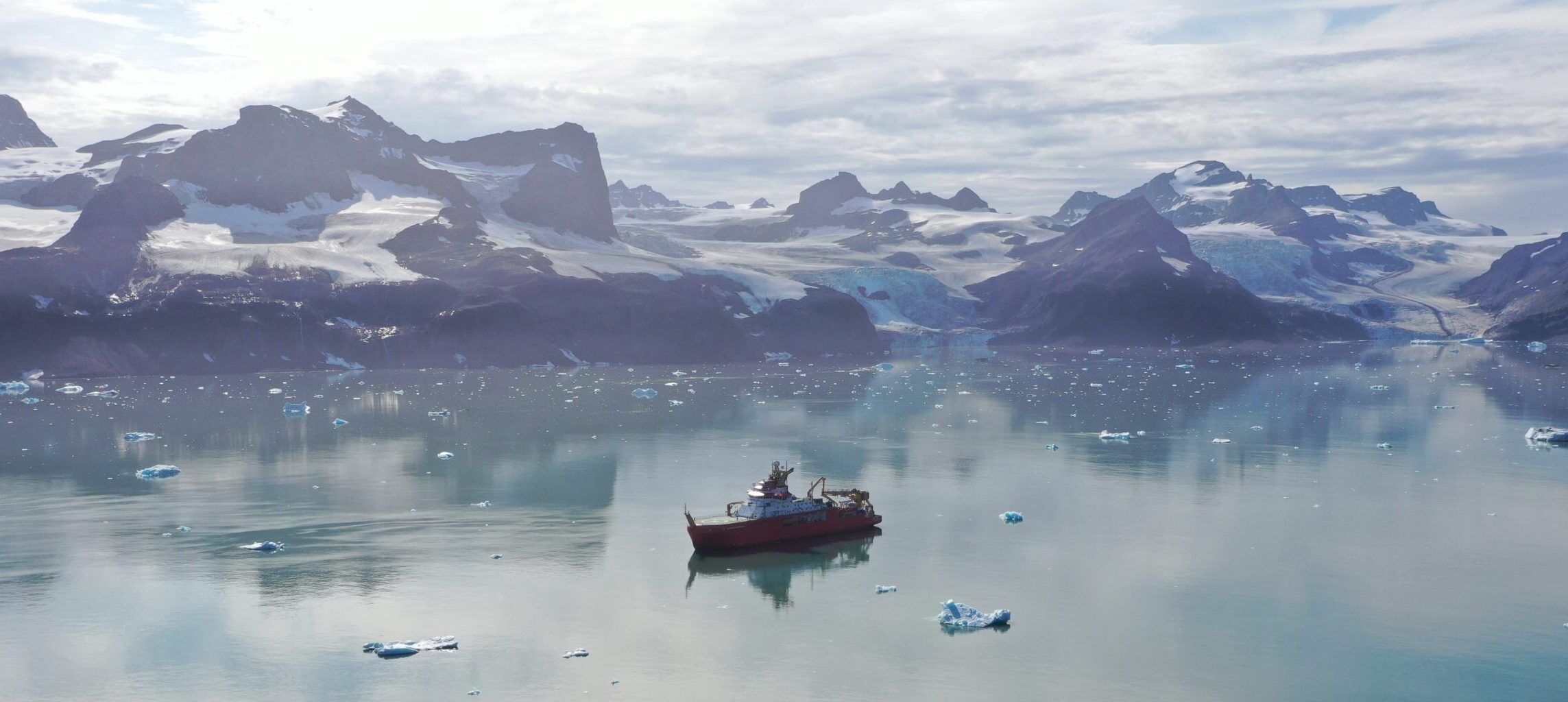
The research vessel RRS Sir David Attenborough, owned by the Natural Environment Research Council (NERC) and operated by BAS, will transport scientists and equipment to near Kangerlussuaq Fjord. Acting as both a floating laboratory and a launch platform for autonomous vehicles, the ship will also conduct detailed measurements of fjord depth and shape, as well as ocean temperature, salinity and currents.
Among the many advanced tools deployed will be an uncrewed surface vessel mapping the underwater shape of glacier fronts using multibeam sonar, a range of drones surveying glacier surfaces from above, satellites providing continuous large-scale monitoring, and sensors drilled into the ice to measure real-time melting and structural weakening of the glacier. In addition, a fleet of autonomous underwater vehicles will collect data at the glacier front and along the fjords. In combination, these observations will reveal how glaciers are responding to ocean warming.
Dr Kelly Hogan, Co-creator on GIANT and a climate scientist at BAS said:
“This is a massively ambitious project and is urgent. We know Greenland is losing ice at an unprecedented rate and this will impact the surrounding ocean – from the coastal fjords so important to Greenland’s communities to the large currents that bring heat to Western Europe. We want to ensure we can provide meaningful information to policymakers, so they are informed to make decisions that support the security of society.”
Using the most-advanced robotics to capture data
Dr Pierre Dutrieux, an oceanographer at BAS, is an expert in autonomous instruments to capture data from extreme ocean and ice environments. He’s a Co-creator on the GIANT project. He said:
“If we want to understand how glaciers melt and fracture, we need to be where the action happens – where the ice meets the ocean. The latest generation of robotic sensors are needed to work in this hazardous environment, which is otherwise impossible to access.”
Jonathan Nash, from Oregon State University in the US, is part of the team planning to deploy a sophisticated piece of equipment called the Meltstake that will be affixed to the glacier edge to measure melting. He says:
“Our group makes observations of the melt process at the glacier-ocean boundary – which can reveal how details that may appear like minutiae at first (like bubbles popping from glacier ice, or sediments raining down from muddy ocean waters) can play a critical role to the dynamics. Every time we observe, we learn something unexpected.”
Oceanographer Prof. Mark Inall from Scottish Association of Marine Science who will deploy the autonomous submarine Gavia, said:
“It may seem hard to believe that activity in the seawater near to a glacier makes any difference to the UK climate – let alone the rest of the world – but it does. How quickly and to what extent are the questions we seek to answer by using advanced robotic and numerical science and an international team led from the UK.”

Cutting-edge climate modelling
A key strength of the GIANT project is that its computer modelling work will run in parallel with observational and field data collection. Existing large-scale climate models, including the UK Earth System Model (UKESM), currently omit or misrepresent key processes occurring where Greenland’s glaciers meet the ocean. GIANT will run a hierarchy of computer simulations of glaciers and fjords, at different scales, with the aim of incorporating fjords into the UKESM. By the end of the project, the new observations will allow us to build in everything from ice cracking and calving to the export of freshwater into the North Atlantic.
Prof. Paul Holland is leading the computer modelling efforts for GIANT. He said:
“Trying to build modelling systems that can capture abrupt glacier change is bold and risky. The science is intricate, and there’s a real chance we won’t be able to predict sudden ice losses. But even if it doesn’t pan out, the insights we gain will improve the skill of climate forecasting and fill a gap that’s currently missing for our understanding of how Greenland might affect the ocean in the future.”
Glaciologist Dr Donald Slater from University of Edinburgh is part of the team. He said:
“Modelling these systems is incredibly hard partly because processes that happen within millimetres of the ice might affect ocean currents hundreds of miles away. We have some promising prototype computer models that might capture this range of scales, but we badly need observations from Greenland’s fjords to test and refine these prototypes.”

Dr Scott Hosking, Mission Director for Environmental Forecasting at the Alan Turing Institute, said:
“By using AI to fuse data from satellites, ships, and autonomous vehicles, we are transforming fragmented observations into readily usable information. We are leveraging the open-source DeepSensor toolkit to provide the precise mapping of ice sheet conditions needed to model dynamical behaviour and accurately predict the risk of sudden ice loss and its impact on the global ocean.”
The race for an Early Warning System
Alongside climate modelling, GIANT will trial a prototype Early Warning System for glacier change. This online system will combine satellite observations, field data, artificial intelligence and statistical glacier modelling to predict when ice loss into the North Atlantic might suddenly increase. The long-term vision is to create an operational early warning system for Greenland’s glaciers – one capable of flagging heightened risk of abrupt change.
The implications of Greenland’s melting glaciers extend far beyond the local people who live there. Locally, glacier collapse and retreat mean that fjords are freezing over later each year, and coastal communities can no longer rely on ice fishing for their livelihoods. Globally, the flow of freshwater into the North Atlantic could disrupt ocean circulation patterns that help regulate Europe’s climate and weather, while also contributing to global sea-level rise.
By working towards an Early Warning System, researchers hope they can provide crucial data to help governments prepare and adapt for the consequences of the planet’s changing climate.
Sarah Bohndiek, Programme Director for ARIA’s Forecasting Tipping Points programme, said:
“We are currently unable to forecast when climate tipping points might be crossed, leaving us poorly equipped to handle the potentially irreversible consequences of tipping points in Greenland and the Subpolar Gyre. Developing an early warning system is necessary to provide governments, industry and society more broadly the information they need to build resilience and accelerate proactive climate adaptation.”
Find out more at giantgreenland.com.