
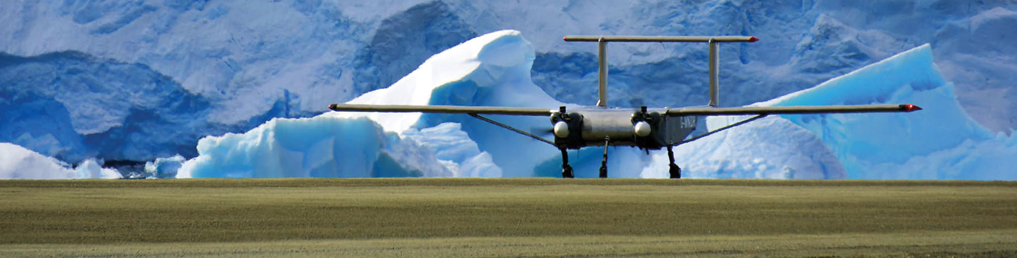
How large drones help us see more of Antarctica
To understand Antarctica – its ice sheets, its geology, its wildlife, its role in shaping the world’s oceans and climate – you have to get into the air.

Airborne surveys are fundamental to polar science. They can reveal what lies beneath the ice, track changes in fragile ecosystems and measure the forces that shape the atmosphere. But in Antarctica, aircraft time is one of the scarcest resources a scientist can have. The operating season is short, crewed flights are in high demand and there is always more to discover than there is time in the sky.
For more than a decade, scientists have hoped that large autonomous drones could help – not by replacing crewed aviation, but by working alongside it. Drones could open up new routes for science, take on repeat surveys and reach places that are difficult, costly or risky to study by conventional means.
In 2024, backed by multi-million pound UK government investment, BAS set out to test that promise in Antarctica.
Working with leading UK drone manufacturer Windracers and partners from academia and industry, BAS helped to deploy the UK’s largest civil autonomous drone – the Windracers Ultra – for a full season of scientific flying from Rothera Research Station on the Antarctic Peninsula.
With a 10-metre wingspan and the ability to carry over 100 kg of research instruments, the aircraft can be flown autonomously and monitored remotely from the UK, reducing the number of people needed on the ground in Antarctica.
Across 25 missions, the drone flew almost 3,000 km, all beyond visual line of sight. Some flights lasted more than two hours and covered 260 km in a single pass. The aircraft collected visual and hyperspectral imagery of Antarctic landscapes and specially protected areas, measured atmospheric turbulence where ocean and atmosphere meet and gathered gravity and magnetic data that shed new light on the ancient geology buried beneath the ice.
These were not just test flights. The aircraft collected valuable data, with the results now shared through peer-reviewed publications.
Crucially, the drone operated alongside BAS crewed aircraft, coordinating with Rothera’s air traffic control and sharing the same sky. This is an essential first step for large autonomous drones to become a routine part of how Antarctic science is done.
The case for doing so is compelling. Each autonomous drone has distinct and useful qualities. They can fly longer, carry different instruments or repeat surveys more easily – delivering high value science at a potentially lower carbon footprint. And by taking on work that doesn’t require a human on board, it could free up BAS pilots and planes for the work only they can do – allowing more science to happen within each precious Antarctic season.
The impact of the BAS test mission was felt almost immediately. Two leading international research organisations went on to purchase four Windracers ULTRA aircraft.
The Norwegian NORCE institute cited the successful flights from Rothera as a key factor in its decision to buy two Windracers ULTRA aircraft for its own Antarctic programme. The University of Fairbanks Alaska also purchased two aircraft with plans to explore how autonomous drones could support research and help supply remote communities.
These were the first international sales of their kind, secured in part because BAS had demonstrated the technology’s effectiveness in one of the most demanding flying environments on Earth. It is a clear example of the commercial return that UK government investment in science can generate.
The story doesn’t end at the poles. The same aircraft has been trialled delivering mail and medical supplies to some of Britain’s island communities – including the Isles of Scilly, Orkney and Shetland. Windracers now has an operational base in Madagascar, where it is demonstrating how the aircraft could support humanitarian aid delivery in areas that conventional logistics cannot easily or affordably serve. In summer 2027, the aircraft will head to Greenland funded by a UK government sponsored research programme, where it will measure ice thickness and count narwhal populations.
By helping prove this technology in Antarctica, BAS has opened the door to uses far beyond the ice – from wildfire detection to emergency logistics and humanitarian aid in some of the world’s most remote communities.
The return on public investment is already taking shape: more knowledge from every Antarctic season, a stronger UK technology and a new way to reach the places and the people that are hardest to get to.